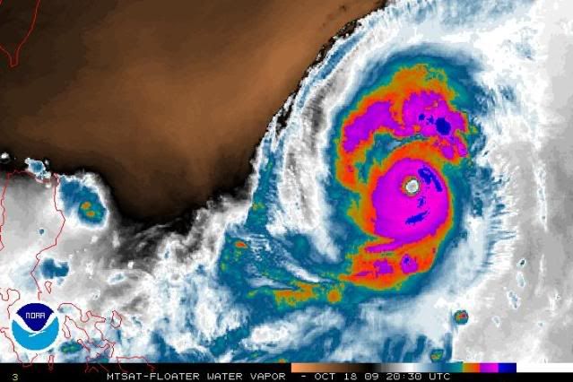
WPAC: SEVERE TROPICAL STORM LUPIT (22W)

Moderator: S2k Moderators

Message
Author
User avatar
drdavisjr
Category 1
Category 1
Posts: 428
Age: 57
Joined: Mon Oct 12, 2009 7:07 am
Location: Marilao, Bulacan, Philippines
Contact:

Re: WPAC: TYPHOON LUPIT (22W)

#301 Postby drdavisjr » Sun Oct 18, 2009 11:13 am

theavocado wrote:
drdavisjr wrote:I think that someone posted that there are three numerical models that support a northeast tract.


Be careful picking and choosing models with favorable outputs. That comment was taken out of context, and what the Prognostic Reasoning said was that those three models took it to the northeast as outliers. The three models are the non-global models (WBAR, a barotropic tracker; TCLAPS, a regional tracker designed for the southern hem; GFDN, a nested tracker within NOGAPS), however, the rest of the models within the JTWC consensus are all global full spectrum models that have been performing better (JGSM, UKMO, ECMWF, NOGAPS, GFS) and call for a westward track. Other models that aren't in the consensus also agree with a westerly track (MM5, COAMPS, CMC).


Thank you for clarifying that.
0 likes   

CrazyC83
Professional-Met
Professional-Met
Posts: 34002
Joined: Tue Mar 07, 2006 11:57 pm
Location: Deep South, for the first time!

#302 Postby CrazyC83 » Sun Oct 18, 2009 11:19 am

Any other day, this would seem like one amazing storm - but Rick dwarfed it!
0 likes   

Derek Ortt

Re: Re:

#303 Postby Derek Ortt » Sun Oct 18, 2009 11:55 am

drdavisjr wrote:
Derek Ortt wrote:finally got the output of yesterdays mm5 off of cmc, and it shows recurve now. The other two are still showing westward turn


So, do you think it will recurve, loop, or turn west?


still thinking west, though the threat may be increasing for Taiwan
0 likes   

CrazyC83
Professional-Met
Professional-Met
Posts: 34002
Joined: Tue Mar 07, 2006 11:57 pm
Location: Deep South, for the first time!

#304 Postby CrazyC83 » Sun Oct 18, 2009 1:05 pm

UW - CIMSS
ADVANCED DVORAK TECHNIQUE
ADT-Version 7.2.3
Tropical Cyclone Intensity Algorithm

----- Current Analysis -----
Date : 18 OCT 2009 Time : 171500 UTC
Lat : 17:59:51 N Lon : 134:05:44 E


CI# /Pressure/ Vmax
6.9 / 903.1mb/137.4kt


Final T# Adj T# Raw T#
(3hr avg)
6.9 7.1 7.1

Latitude bias adjustment to MSLP : +1.9mb

Estimated radius of max. wind based on IR : 25 km

Center Temp : +12.5C Cloud Region Temp : -76.8C

Scene Type : EYE

Positioning Method : RING/SPIRAL COMBINATION

Ocean Basin : WEST PACIFIC
Dvorak CI > MSLP Conversion Used : PACIFIC

Tno/CI Rules : Constraint Limits : NO LIMIT
Weakening Flag : OFF
Rapid Dissipation Flag : OFF
0 likes   

User avatar
P.K.
Professional-Met
Professional-Met
Posts: 5149
Joined: Thu Sep 23, 2004 5:57 pm
Location: Watford, England
Contact:

Re: WPAC: TYPHOON LUPIT (22W)

#305 Postby P.K. » Sun Oct 18, 2009 1:35 pm

JMA are up to T6.5 now. JTWC now up to T7.0.

TPPN11 PGTW 181818

A. SUPER TYPHOON 22W (LUPIT)

B. 18/1730Z

C. 18.0N

D. 134.1E

E. TWO/MTSAT

F. T7.0/7.0/D0.5/24HRS STT: D1.0/12HRS

G. IR/EIR

H. REMARKS: 01A/PBO EYE/ANMTN. 24NM WMG EYE SURROUNDED BY WHITE
CONVECTIVE RING YIELDS A 6.0 E#. 1.0 ADDED FOR EYE ADJUSTMENT
YIELDS 7.0 DT. MET AND PT AGREE. DBO DT.

I. ADDITIONAL POSITIONS:
18/1231Z 17.9N 134.0E AMSU


SMITH
0 likes   

User avatar
theavocado
Professional-Met
Professional-Met
Posts: 162
Age: 49
Joined: Sun Mar 22, 2009 8:54 pm
Location: NOLA

Re: WPAC: TYPHOON LUPIT (22W)

#306 Postby theavocado » Sun Oct 18, 2009 1:50 pm

P.K. wrote:JMA are up to T6.5 now. JTWC now up to T7.0.

TPPN11 PGTW 181818

A. SUPER TYPHOON 22W (LUPIT)

B. 18/1730Z

C. 18.0N

D. 134.1E

E. TWO/MTSAT

F. T7.0/7.0/D0.5/24HRS STT: D1.0/12HRS

G. IR/EIR

H. REMARKS: 01A/PBO EYE/ANMTN. 24NM WMG EYE SURROUNDED BY WHITE
CONVECTIVE RING YIELDS A 6.0 E#. 1.0 ADDED FOR EYE ADJUSTMENT
YIELDS 7.0 DT. MET AND PT AGREE. DBO DT.

I. ADDITIONAL POSITIONS:
18/1231Z 17.9N 134.0E AMSU


SMITH


Also of note on this fix is a more poleward motion in the track.
0 likes   

User avatar
JTE50
Category 1
Category 1
Posts: 336
Age: 67
Joined: Mon Jul 21, 2008 10:48 am
Location: Pensacola
Contact:

Re: WPAC: TYPHOON LUPIT (22W)

#307 Postby JTE50 » Sun Oct 18, 2009 2:07 pm

You can see the poleward movement clearly here in the last few frames:
http://www.goes.noaa.gov/guam/guamloops/guamircolor.html
0 likes   

User avatar
cycloneye
Admin
Admin
Posts: 145303
Age: 68
Joined: Thu Oct 10, 2002 10:54 am
Location: San Juan, Puerto Rico

Re: WPAC: TYPHOON LUPIT (22W)

#308 Postby cycloneye » Sun Oct 18, 2009 2:09 pm

JMA 18 UTC Warning:

TY 0920 (Lupit)
Issued at 18:45 UTC, 18 October 2009
<Analyses at 18/18 UTC>
Scale -
Intensity Very Strong
Center position N18°00'(18.0°)
E134°10'(134.2°)
Direction and speed of movement NNE Slowly
Central pressure 930hPa
Maximum wind speed near the center 50m/s(95kt)
Maximum wind gust speed 70m/s(135kt)
Area of 50kt winds or more Wide 240km(130NM)
Area of 30kt winds or more SW500km(270NM)
NE410km(220NM)

<Forecast for 19/18 UTC>
Intensity Very Strong
Center position of probability circle N18°30'(18.5°)
E131°40'(131.7°)
Direction and speed of movement W 15km/h(7kt)
Central pressure 930hPa
Maximum wind speed near the center 50m/s(95kt)
Maximum wind gust speed 70m/s(135kt)
Radius of probability circle 130km(70NM)
Storm warning area Wide 370km(200NM)

<Forecast for 20/18 UTC>
Intensity Very Strong
Center position of probability circle N18°55'(18.9°)
E127°25'(127.4°)
Direction and speed of movement W 20km/h(10kt)
Central pressure 930hPa
Maximum wind speed near the center 50m/s(95kt)
Maximum wind gust speed 70m/s(135kt)
Radius of probability circle 200km(110NM)
Storm warning area Wide 440km(240NM)

<Forecast for 21/18 UTC>
Intensity Very Strong
Center position of probability circle N18°05'(18.1°)
E122°10'(122.2°)
Direction and speed of movement W 20km/h(12kt)
Central pressure 940hPa
Maximum wind speed near the center 45m/s(85kt)
Maximum wind gust speed 60m/s(120kt)
Radius of probability circle 390km(210NM)
Storm warning area Wide 600km(325NM)

Image
0 likes   
Visit the Caribbean-Central America Weather Thread where you can find at first post web cams,radars
and observations from Caribbean basin members Click Here

ozonepete
Professional-Met
Professional-Met
Posts: 4743
Joined: Mon Sep 07, 2009 3:23 pm
Location: From Ozone Park, NYC / Now in Brooklyn, NY

Re: Re:

#309 Postby ozonepete » Sun Oct 18, 2009 2:55 pm

Derek Ortt wrote:
drdavisjr wrote:
Derek Ortt wrote:finally got the output of yesterdays mm5 off of cmc, and it shows recurve now. The other two are still showing westward turn


So, do you think it will recurve, loop, or turn west?


still thinking west, though the threat may be increasing for Taiwan


I agree with you, Derek. The last few images show what looks like a significant slowdown and a turn in direction to north from NNE. That would indicate it will make its left turn after all. But it has gained just enough extra latitude, and will gain a little more, to make Taiwan a possible target. Also, it's going so slowly that by the time it nears the northern Philippines another shortwave may come in and pull it poleward again.
0 likes   

User avatar
cycloneye
Admin
Admin
Posts: 145303
Age: 68
Joined: Thu Oct 10, 2002 10:54 am
Location: San Juan, Puerto Rico

Re: WPAC: TYPHOON LUPIT (22W)

#310 Postby cycloneye » Sun Oct 18, 2009 3:00 pm

2100z JTWC Warning=135kts

WTPN31 PGTW 182100
MSGID/GENADMIN/NAVMARFCSTCEN PEARL HARBOR HI/JTWC//
SUBJ/TROPICAL CYCLONE WARNING//
RMKS/
1. SUPER TYPHOON 22W (LUPIT) WARNING NR 020
01 ACTIVE TROPICAL CYCLONE IN NORTHWESTPAC
MAX SUSTAINED WINDS BASED ON ONE-MINUTE AVERAGE
WIND RADII VALID OVER OPEN WATER ONLY
---
WARNING POSITION:
181800Z --- NEAR 18.0N 134.2E
MOVEMENT PAST SIX HOURS - 025 DEGREES AT 04 KTS
POSITION ACCURATE TO WITHIN 025 NM
POSITION BASED ON EYE FIXED BY SATELLITE
PRESENT WIND DISTRIBUTION:
MAX SUSTAINED WINDS - 135 KT, GUSTS 165 KT
WIND RADII VALID OVER OPEN WATER ONLY
RADIUS OF 064 KT WINDS - 055 NM NORTHEAST QUADRANT
055 NM SOUTHEAST QUADRANT
055 NM SOUTHWEST QUADRANT
055 NM NORTHWEST QUADRANT
RADIUS OF 050 KT WINDS - 080 NM NORTHEAST QUADRANT
090 NM SOUTHEAST QUADRANT
085 NM SOUTHWEST QUADRANT
080 NM NORTHWEST QUADRANT
RADIUS OF 034 KT WINDS - 140 NM NORTHEAST QUADRANT
145 NM SOUTHEAST QUADRANT
145 NM SOUTHWEST QUADRANT
135 NM NORTHWEST QUADRANT
REPEAT POSIT: 18.0N 134.2E
---
FORECASTS:
12 HRS, VALID AT:
190600Z --- 18.8N 134.2E
MAX SUSTAINED WINDS - 135 KT, GUSTS 165 KT
WIND RADII VALID OVER OPEN WATER ONLY
RADIUS OF 064 KT WINDS - 050 NM NORTHEAST QUADRANT
050 NM SOUTHEAST QUADRANT
050 NM SOUTHWEST QUADRANT
050 NM NORTHWEST QUADRANT
RADIUS OF 050 KT WINDS - 080 NM NORTHEAST QUADRANT
085 NM SOUTHEAST QUADRANT
080 NM SOUTHWEST QUADRANT
080 NM NORTHWEST QUADRANT
RADIUS OF 034 KT WINDS - 140 NM NORTHEAST QUADRANT
140 NM SOUTHEAST QUADRANT
140 NM SOUTHWEST QUADRANT
135 NM NORTHWEST QUADRANT
VECTOR TO 24 HR POSIT: 305 DEG/ 06 KTS
---
24 HRS, VALID AT:
191800Z --- 19.4N 133.2E
MAX SUSTAINED WINDS - 130 KT, GUSTS 160 KT
WIND RADII VALID OVER OPEN WATER ONLY
RADIUS OF 064 KT WINDS - 045 NM NORTHEAST QUADRANT
045 NM SOUTHEAST QUADRANT
045 NM SOUTHWEST QUADRANT
050 NM NORTHWEST QUADRANT
RADIUS OF 050 KT WINDS - 075 NM NORTHEAST QUADRANT
080 NM SOUTHEAST QUADRANT
080 NM SOUTHWEST QUADRANT
075 NM NORTHWEST QUADRANT
RADIUS OF 034 KT WINDS - 140 NM NORTHEAST QUADRANT
135 NM SOUTHEAST QUADRANT
140 NM SOUTHWEST QUADRANT
140 NM NORTHWEST QUADRANT
VECTOR TO 36 HR POSIT: 280 DEG/ 09 KTS
---
36 HRS, VALID AT:
200600Z --- 19.7N 131.4E
MAX SUSTAINED WINDS - 125 KT, GUSTS 150 KT
WIND RADII VALID OVER OPEN WATER ONLY
RADIUS OF 064 KT WINDS - 045 NM NORTHEAST QUADRANT
045 NM SOUTHEAST QUADRANT
045 NM SOUTHWEST QUADRANT
045 NM NORTHWEST QUADRANT
RADIUS OF 050 KT WINDS - 075 NM NORTHEAST QUADRANT
075 NM SOUTHEAST QUADRANT
075 NM SOUTHWEST QUADRANT
075 NM NORTHWEST QUADRANT
RADIUS OF 034 KT WINDS - 135 NM NORTHEAST QUADRANT
135 NM SOUTHEAST QUADRANT
140 NM SOUTHWEST QUADRANT
140 NM NORTHWEST QUADRANT
VECTOR TO 48 HR POSIT: 270 DEG/ 11 KTS
---
EXTENDED OUTLOOK:
48 HRS, VALID AT:
201800Z --- 19.7N 129.1E
MAX SUSTAINED WINDS - 125 KT, GUSTS 150 KT
WIND RADII VALID OVER OPEN WATER ONLY
RADIUS OF 064 KT WINDS - 045 NM NORTHEAST QUADRANT
045 NM SOUTHEAST QUADRANT
045 NM SOUTHWEST QUADRANT
045 NM NORTHWEST QUADRANT
RADIUS OF 050 KT WINDS - 075 NM NORTHEAST QUADRANT
075 NM SOUTHEAST QUADRANT
075 NM SOUTHWEST QUADRANT
075 NM NORTHWEST QUADRANT
RADIUS OF 034 KT WINDS - 135 NM NORTHEAST QUADRANT
130 NM SOUTHEAST QUADRANT
135 NM SOUTHWEST QUADRANT
140 NM NORTHWEST QUADRANT
VECTOR TO 72 HR POSIT: 265 DEG/ 11 KTS
---
72 HRS, VALID AT:
211800Z --- 19.2N 124.4E
MAX SUSTAINED WINDS - 120 KT, GUSTS 145 KT
WIND RADII VALID OVER OPEN WATER ONLY
RADIUS OF 064 KT WINDS - 045 NM NORTHEAST QUADRANT
045 NM SOUTHEAST QUADRANT
045 NM SOUTHWEST QUADRANT
045 NM NORTHWEST QUADRANT
RADIUS OF 050 KT WINDS - 070 NM NORTHEAST QUADRANT
070 NM SOUTHEAST QUADRANT
070 NM SOUTHWEST QUADRANT
075 NM NORTHWEST QUADRANT
RADIUS OF 034 KT WINDS - 135 NM NORTHEAST QUADRANT
130 NM SOUTHEAST QUADRANT
135 NM SOUTHWEST QUADRANT
140 NM NORTHWEST QUADRANT
VECTOR TO 96 HR POSIT: 260 DEG/ 11 KTS
---
LONG RANGE OUTLOOK:
NOTE...ERRORS FOR TRACK HAVE AVERAGED NEAR 250 NM
ON DAY 4 AND 350 NM ON DAY 5... AND FOR INTENSITY
NEAR 20 KT EACH DAY.
---
96 HRS, VALID AT:
221800Z --- 18.5N 119.6E
MAX SUSTAINED WINDS - 105 KT, GUSTS 130 KT
WIND RADII VALID OVER OPEN WATER ONLY
VECTOR TO 120 HR POSIT: 265 DEG/ 11 KTS
---
120 HRS, VALID AT:
231800Z --- 17.9N 115.2E
MAX SUSTAINED WINDS - 100 KT, GUSTS 125 KT
WIND RADII VALID OVER OPEN WATER ONLY
---
REMARKS:
182100Z POSITION NEAR 18.2N 134.2E. SUPER TYPHOON (STY) 22W (LUPIT),
LOCATED APPROXIMATELY 790 NM EAST-NORTHEAST OF MANILA, PHILIPPINES,
HAS TRACKED NORTH-NORTHEASTWARD AT 04 KNOTS OVER THE PAST SIX HOURS.
RECENT ANIMATED INFRARED IMAGERY SHOWS AN IMPRESSIVE SYSTEM WITH A
DEEP, SYMMETRIC RING OF CONVECTION SURROUNDING A LARGE, WELL FORMED
EYE. MULTIPLE DEEP CONVECTIVE BANDS WRAPPING INTO THE SYSTEM ARE
ALSO EVIDENT, AS IS STRONG DUAL CHANNEL OUTFLOW TO THE NORTHEAST AND
SOUTHWEST. AN 181644Z AMSR-E PASS SHOWS A RING OF CONVECTION AROUND
THE EYE WITH SOME INDICATION OF A MOAT SEPARATING THE RING FROM THE
CONVECTION ASSOCIATED WITH THE BANDING. ALSO SEEN IN THE AMSR-E PASS
IS CONTINUED DEFORMATION OF THE INFLOW AND BANDING ON THE NORTHWEST
QUADRANT DUE TO PASSAGE OF A MIDLATITUDE TROUGH TO THE NORTH.
INTENSITY IS BASED ON ESTIMATES FROM PGTW, RJTD AND KNES. POSITION
IS BASED ON FIXES FROM PGTW AND RJTD, AND THE POSITION SHOWS A TRACK
THAT IS BECOMING MORE POLEWARD. AS THE MIDLATITUDE TROUGH TO THE
NORTH MOVES OUT OF THE AREA AND THE SUBTROPICAL RIDGE (STR) EAST OF
STY 22W BUILDS IN TO THE NORTHWEST, THE SYSTEM WILL TURN TO A MORE
WESTERLY TRACK AROUND TAU 12 AND ACCELERATE UNDER THE STEERING
INFLUENCE OF THE STR. STRONG RIDGING OVER SOUTHERN CHINA WILL CAUSE
THE SYSTEM TO TRACK SLIGHTLY SOUTH OF DUE WEST AND PASS NEAR THE
NORTHERN TIP OF LUZON. NUMERICAL GUIDANCE IS IMPROVING WITH MOST
MODELS TURNING THE SYSTEM WESTWARD BY TAU 12, WITH VARYING DEGREES
OF TURN RATE. THE ONE NOTABLE EXCEPTION IS WBAR WHICH CONTINUES TO
BRING THE SYSTEM INTO THE MIDLATITUDE FLOW AND TO THE NORTHEAST.
MAXIMUM SIGNIFICANT WAVE HEIGHT AT 181800Z IS 30 FEET. NEXT WARNINGS
AT 190300Z, 190900Z, 191500Z AND 192100Z.//

Image
0 likes   
Visit the Caribbean-Central America Weather Thread where you can find at first post web cams,radars
and observations from Caribbean basin members Click Here

ozonepete
Professional-Met
Professional-Met
Posts: 4743
Joined: Mon Sep 07, 2009 3:23 pm
Location: From Ozone Park, NYC / Now in Brooklyn, NY

Re: WPAC: TYPHOON LUPIT (22W)

#311 Postby ozonepete » Sun Oct 18, 2009 3:15 pm

NUMERICAL GUIDANCE IS IMPROVING WITH MOST MODELS TURNING THE SYSTEM WESTWARD BY TAU 12, WITH VARYING DEGREES OF TURN RATE. THE ONE NOTABLE EXCEPTION IS WBAR WHICH CONTINUES TO BRING THE SYSTEM INTO THE MIDLATITUDE FLOW AND TO THE NORTHEAST.

So TCLAPS and GFDN have come around to the westward turn. That makes it virtually unanimous. And on the water vapor loop you can see the STR rebuilding westward now towards Lupit. Although all of that north-northeastward motion last night has pushed back the timing of the westward turn, it will not prevent it.

There are however, all sorts of issues with the strength given it's really slow movement (upwelling) for the next day and a half and some pretty dry air to to its northwest.
0 likes   

User avatar
theavocado
Professional-Met
Professional-Met
Posts: 162
Age: 49
Joined: Sun Mar 22, 2009 8:54 pm
Location: NOLA

Re: WPAC: TYPHOON LUPIT (22W)

#312 Postby theavocado » Sun Oct 18, 2009 3:25 pm

ozonepete wrote:There are however, all sorts of issues with the strength given it's really slow movement (upwelling) for the next day and a half and some pretty dry air to to its northwest.


Don't forget the possibility of an EWRC:

AN 181644Z AMSR-E PASS SHOWS A RING OF CONVECTION AROUND THE EYE WITH SOME INDICATION OF A MOAT SEPARATING THE RING FROM THE CONVECTION ASSOCIATED WITH THE BANDING.
0 likes   

ozonepete
Professional-Met
Professional-Met
Posts: 4743
Joined: Mon Sep 07, 2009 3:23 pm
Location: From Ozone Park, NYC / Now in Brooklyn, NY

Re: WPAC: TYPHOON LUPIT (22W)

#313 Postby ozonepete » Sun Oct 18, 2009 3:28 pm

theavocado wrote:
ozonepete wrote:There are however, all sorts of issues with the strength given it's really slow movement (upwelling) for the next day and a half and some pretty dry air to to its northwest.


Don't forget the possibility of an EWRC:

AN 181644Z AMSR-E PASS SHOWS A RING OF CONVECTION AROUND THE EYE WITH SOME INDICATION OF A MOAT SEPARATING THE RING FROM THE CONVECTION ASSOCIATED WITH THE BANDING.


I did. :oops: Thanks for pointing it out. :)
0 likes   

Derek Ortt

#314 Postby Derek Ortt » Sun Oct 18, 2009 4:08 pm

WBAR... it is quite similar to LBAR
0 likes   

oaba09
S2K Supporter
S2K Supporter
Posts: 1496
Age: 38
Joined: Thu Oct 01, 2009 10:02 am
Location: Valenzuela, Philippines
Contact:

#315 Postby oaba09 » Sun Oct 18, 2009 4:16 pm

According to PAGASA, it started moving northwest slowly.......Any confirmation with this? I dunno, maybe they were just assuming that it will turn NW...
0 likes   

ozonepete
Professional-Met
Professional-Met
Posts: 4743
Joined: Mon Sep 07, 2009 3:23 pm
Location: From Ozone Park, NYC / Now in Brooklyn, NY

Re:

#316 Postby ozonepete » Sun Oct 18, 2009 4:25 pm

oaba09 wrote:According to PAGASA, it started moving northwest slowly.......Any confirmation with this? I dunno, maybe they were just assuming that it will turn NW...


I don't see it. But you have to remember that very strong tropical cyclones often wobble along their track. So you can't look at 1 or 2 images and deduce the true motion from them. Maybe they're looking at wobbles? I have no idea how they come up with their forecasts or analysis.
0 likes   

ozonepete
Professional-Met
Professional-Met
Posts: 4743
Joined: Mon Sep 07, 2009 3:23 pm
Location: From Ozone Park, NYC / Now in Brooklyn, NY

Re: WPAC: TYPHOON LUPIT (22W)

#317 Postby ozonepete » Sun Oct 18, 2009 4:37 pm

The overall motion still looks northeastward, albeit really slowly. I have to be careful myself not to watch wobbles - you'll go crazy!

On an important note, dry air appears to be working in on the western side. Too early to tell how much effect it will have.

Image
0 likes   

User avatar
theavocado
Professional-Met
Professional-Met
Posts: 162
Age: 49
Joined: Sun Mar 22, 2009 8:54 pm
Location: NOLA

Re:

#318 Postby theavocado » Sun Oct 18, 2009 4:39 pm

Derek Ortt wrote:WBAR... it is quite similar to LBAR


WBAR, LBAR, VICBAR...they all struggle with midlatitude (read: baroclinic) interaction.

For those that don't know, the above models are Barotropic models. They are relatively simple models that initialize off of global models (LBAR off GFS and WBAR off NOGAPS, if I'm not mistaken) using mean layer winds and height fields. The model then steers the system using the "Plinko" method of bouncing the disc (represented by the cyclone) through the pegs (represented by areas of higher heights).

Once baroclinicity is introduced (density changing with both pressure and temperature) the model does funny things like over respond to a midlatitude system.
0 likes   

ozonepete
Professional-Met
Professional-Met
Posts: 4743
Joined: Mon Sep 07, 2009 3:23 pm
Location: From Ozone Park, NYC / Now in Brooklyn, NY

Re: Re:

#319 Postby ozonepete » Sun Oct 18, 2009 4:57 pm

theavocado wrote:
Derek Ortt wrote:WBAR... it is quite similar to LBAR


WBAR, LBAR, VICBAR...they all struggle with midlatitude (read: baroclinic) interaction.

For those that don't know, the above models are Barotropic models. They are relatively simple models that initialize off of global models (LBAR off GFS and WBAR off NOGAPS, if I'm not mistaken) using mean layer winds and height fields. The model then steers the system using the "Plinko" method of bouncing the disc (represented by the cyclone) through the pegs (represented by areas of higher heights).

Once baroclinicity is introduced (density changing with both pressure and temperature) the model does funny things like over respond to a midlatitude system.


Which it appears the WBAR did in the last run. BTW, this is from the NHC site: LBAR is the NHC's implementation of the GFDL VICBAR model.
0 likes   

ozonepete
Professional-Met
Professional-Met
Posts: 4743
Joined: Mon Sep 07, 2009 3:23 pm
Location: From Ozone Park, NYC / Now in Brooklyn, NY

Re: WPAC: TYPHOON LUPIT (22W)

#320 Postby ozonepete » Sun Oct 18, 2009 4:59 pm

Still gaining latitude. North of 18N now.
0 likes   


Return to “2009”

Who is online

Users browsing this forum: No registered users and 3 guests