
ATL: TROPICAL DEPRESSION HENRI (10L)
Moderator: S2k Moderators
-
Blown Away

- S2K Supporter

- Posts: 10253
- Joined: Wed May 26, 2004 6:17 am
Re:
gatorcane wrote:There is no NW movement, movement is WNW as it has been all day. The shear can easily make it look like NW or N movement.
Here is the 18Z zonal shear animation. This looks to me like shear really decreases as it gets under the ridge. What am I missing?
http://moe.met.fsu.edu/cgi-bin/gfstc2.c ... =Animation
I'm probably reading the animation wrong, but if 91L stays on a path that takes it NE of the islands it appears shear will be low. Around 140 hours the entire E Caribbean is shear death zone. I think the thinking is 91L will go into the E Caribbean and be sheared to death.
Last edited by Blown Away on Mon Oct 05, 2009 8:54 pm, edited 1 time in total.
0 likes
Hurricane Eye Experience: David 79, Irene 99, Frances 04, Jeanne 04, Wilma 05… Hurricane Brush Experience: Andrew 92, Erin 95, Floyd 99, Matthew 16, Irma 17, Ian 22, Nicole 22…
-
Derek Ortt
-
IvanSurvivor
- Tropical Storm

- Posts: 152
- Joined: Wed Aug 20, 2008 12:12 am
- Location: Pensacola Florida (Warrington)
-
AdamFirst

- S2K Supporter
- Posts: 2490
- Age: 37
- Joined: Thu Aug 14, 2008 10:54 am
- Location: Port Saint Lucie, FL
Re: ATL : INVEST 91L
Emmett_Brown wrote:
The shear maps from Cimms seem to be down right now. This one isn't as good, but it might help. It is from the 12z GFS initialization.

That's bananas. Where is the shear that has been across the Atlantic pretty much the whole summer?
0 likes
Dolphins Marlins Canes Golden Panthers HEAT
Andrew 1992 - Irene 1999 - Frances 2004 - Jeanne 2004 - Wilma 2005 - Fay 2008 - Isaac 2012 - Matthew 2016 - Irma 2017 - Dorian 2019 - Ian 2022 - Nicole 2022 - Milton 2024
Andrew 1992 - Irene 1999 - Frances 2004 - Jeanne 2004 - Wilma 2005 - Fay 2008 - Isaac 2012 - Matthew 2016 - Irma 2017 - Dorian 2019 - Ian 2022 - Nicole 2022 - Milton 2024

Re: ATL : INVEST 91L
Ridge is building now and invest 91l is moving westward to 270°W since a few hours.
0 likes
-
Blown Away
- S2K Supporter
- Posts: 10253
- Joined: Wed May 26, 2004 6:17 am
Re: ATL : INVEST 91L
OURAGAN wrote:Ridge is building now and invest 91l is moving westward to 270°W since a few hours.
No I think it's still WNW, the ULL to the N of 91L is still tugging.
http://www.ssd.noaa.gov/goes/east/tatl/loop-wv.html
0 likes
Hurricane Eye Experience: David 79, Irene 99, Frances 04, Jeanne 04, Wilma 05… Hurricane Brush Experience: Andrew 92, Erin 95, Floyd 99, Matthew 16, Irma 17, Ian 22, Nicole 22…
-
expat2carib

- S2K Supporter
- Posts: 458
- Joined: Tue Jul 22, 2008 1:44 pm
- Location: Sint Maarten
Re: ATL : INVEST 91L
The next 8 hours will be very interesting. Will it survive? 50/50 is my bet. Sleep well everybody. I'm off.
0 likes
-
gatorcane

- S2K Supporter
- Posts: 23708
- Age: 48
- Joined: Sun Mar 13, 2005 3:54 pm
- Location: Boca Raton, FL
Re:
Derek Ortt wrote:this probably moves well north of the Caribbean. Very strong UL to the NNW of the system, which is drawing it north
yesterday's NOGAPS may have been correct, up and out of here
I don't think so Derek. This one is WNW bound still. That ULL is NNE of the system pulling out to the ENE. Had it deepened into a hurricane by now, I could buy a recurve out to sea at this point, but it does not appear it will deepen rapidly, only slow organization.
I do agree it appears to be north of the Caribbean but a bend back to the west or WSW appears possible with a large ridge that appears to be in the process of setting up shop over the Bahamas,FL, and GOM. 91L should approach the SE side of this large ridge.
0 likes

-
wxmann_91

- Category 5

- Posts: 8007
- Age: 34
- Joined: Fri Jul 15, 2005 2:49 pm
- Location: Southern California
- Contact:
Re: ATL : INVEST 91L
AdamFirst wrote:Emmett_Brown wrote:
The shear maps from Cimms seem to be down right now. This one isn't as good, but it might help. It is from the 12z GFS initialization.
That's bananas. Where is the shear that has been across the Atlantic pretty much the whole summer?
That map is in m/s. That 26 m/s shear just north of 91L is equivalent to ~50 kt. That's some pretty strong shear.
0 likes
-
HURAKAN

- Professional-Met

- Posts: 46084
- Age: 39
- Joined: Thu May 20, 2004 4:34 pm
- Location: Key West, FL
- Contact:

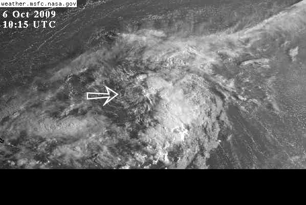
Shear is displacing the LLC from the convection
Loop: http://rammb.cira.colostate.edu/ramsdis ... _floater_2
0 likes
-
cycloneye

- Admin

- Posts: 149843
- Age: 69
- Joined: Thu Oct 10, 2002 10:54 am
- Location: San Juan, Puerto Rico
Re: ATL : INVEST 91L
0 likes
Visit the Caribbean-Central America Weather Thread where you can find at first post web cams,radars
and observations from Caribbean basin members Click Here
and observations from Caribbean basin members Click Here
-
cycloneye
- Admin
- Posts: 149843
- Age: 69
- Joined: Thu Oct 10, 2002 10:54 am
- Location: San Juan, Puerto Rico
Re: ATL : INVEST 91L
A little pass 16N and around 51.5W.
0 likes
Visit the Caribbean-Central America Weather Thread where you can find at first post web cams,radars
and observations from Caribbean basin members Click Here
and observations from Caribbean basin members Click Here
-
wxman57

- Moderator-Pro Met

- Posts: 23178
- Age: 68
- Joined: Sat Jun 21, 2003 8:06 pm
- Location: Houston, TX (southwest)
Re: ATL : INVEST 91L
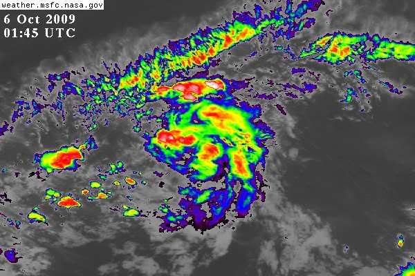
You can see the exposed center now near 16.7N/51.8W. Moving WNW-NW. Moderate SW shear is displacing all convection well NE-E of the weak LLC. Remember, those shear maps are only as good as the data that goes into them. And the data out over the oceans is not very good sometimes. Development chances appear to be diminishing for 91L.
0 likes
-
Gustywind

- Category 5
- Posts: 12334
- Joined: Mon Sep 03, 2007 7:29 am
- Location: Baie-Mahault, GUADELOUPE
000
ABNT20 KNHC 060534
TWOAT
TROPICAL WEATHER OUTLOOK
NWS TPC/NATIONAL HURRICANE CENTER MIAMI FL
200 AM EDT TUE OCT 6 2009
FOR THE NORTH ATLANTIC...CARIBBEAN SEA AND THE GULF OF MEXICO...
SHOWERS AND THUNDERSTORMS ASSOCIATED WITH THE BROAD AREA
OF LOW PRESSURE LOCATED ABOUT 800 MILES EAST OF THE LESSER
ANTILLES HAVE CHANGED LITTLE IN ORGANIZATION DURING PAST SEVERAL
HOURS. THIS SYSTEM STILL HAS THE POTENTIAL TO BECOME A TROPICAL
DEPRESSION DURING THE NEXT DAY OR SO BEFORE UPPER-LEVEL WINDS
BECOME LESS FAVORABLE FOR DEVELOPMENT. THERE IS A MEDIUM CHANCE...
30 TO 50 PERCENT...OF THIS SYSTEM BECOMING A TROPICAL CYCLONE
DURING THE NEXT 48 HOURS AS IT MOVES WEST-NORTHWESTWARD AT ABOUT
15 MPH.
ELSEWHERE...TROPICAL CYCLONE FORMATION IS NOT EXPECTED DURING THE
NEXT 48 HOURS.
$$
FORECASTER BROWN/ROBERTS
0 likes
-
cycloneye
- Admin
- Posts: 149843
- Age: 69
- Joined: Thu Oct 10, 2002 10:54 am
- Location: San Juan, Puerto Rico
Re: ATL : INVEST 91L
AREA FORECAST DISCUSSION
NATIONAL WEATHER SERVICE SAN JUAN PR
311 AM AST TUE OCT 6 2009
.SYNOPSIS...TROPICAL WAVE EXITED THE REGION OVERNIGHT AND HAS
TRACKED A MUCH DRIER AIR MASS INTO THE REGION. EXPECT A DRYING
TREND THROUGH THE WEEK AS A MUCH MORE STABLE AIRMASS MOVES INTO
THE REGION. A STRONG TROPICAL WAVE MAY AFFECT THE REGION THIS
UPCOMING WEEKEND...INCREASING SHOWER AND THUNDERSTORM ACTIVITY
ACROSS THE ENTIRE AREA.
&&
.DISCUSSION...THREE TROPICAL WAVES OF INTEREST ARE THE MAIN PLAYERS IN
TERMS OF LOW LEVEL MOISTURE ADVECTION OVER THE NEXT 5-7 DAYS. THE
FIRST...EXITING THE REGION OVERNIGHT IS HEADED FOR HISPANIOLA AND
TRAILING A MUCH DRIER AIR MASS INTO THE VI/PR NOTABLE ON RADAR AND
SATELLITE. A SECOND...VERY WEAK AND LOW AMPLITUDE WAVE ALONG 60W
OVER THE LEEWARD ISLANDS WILL TRACK WESTWARD THROUGH THE SE
CARIBBEAN THROUGH 36 HOURS. THIS WILL LIKELY EVEN DRY OUT THE
ATMOSPHERE MORE...AS DRY AIR ALONG THE TOP EDGE OF THE WAVE
ADVECTS INTO LOCAL AREA NEXT 36 HOURS. THE THIRD FEATURE...THE
STRONGEST WAVE OF THE THREE IS NEAR 50 WEST AND IS FORECAST TO
HEAD SLOWLY NORTHWESTWARD OVER THE NEXT FEW DAYS...RUNNING INTO A
SOLID WALL OF SOUTHWESTERLY SHEAR. DRY AIR SURROUNDS ALL THREE
SYSTEMS AND WILL BE OVER PUERTO RICO FOR MOST OF THE
WEEK...ESPECIALLY THURSDAY AND FRIDAY AS MID LEVEL RIDGING BECOMES
STRONG OVER THE SW ATLC.
THEREFORE...EXPECTING ONLY ONE MORE DAY OF MODERATE CONVECTION OVER
WESTERN PUERTO RICO THIS AFTERNOON...FOLLOWED BY A SHARP DRYING
TREND WITH STRONG CAPPING TO BUILD AT TOP OF BOUNDARY
LAYER...ENSURING ONLY ISOLATED ACTIVITY AND PLENTY OF SUN FOR THE
REST OF THE WEEK.
BY THE WEEKEND...THE THIRD WAVE MENTIONED ABOVE IS FORECAST TO
WOBBLE AND DIVE SOUTHWESTWARD AND TRACK DEEP MOISTURE ADVECTION INTO
LOCAL REGION. LOOKS LIKE A WET WEEKEND AHEAD...BUT WILL HIGHLY
DEPEND ON THE LONGEVITY OF THIS WAVE.
http://forecast.weather.gov/product.php ... glossary=1
0 likes
Visit the Caribbean-Central America Weather Thread where you can find at first post web cams,radars
and observations from Caribbean basin members Click Here
and observations from Caribbean basin members Click Here

Who is online
Users browsing this forum: No registered users and 38 guests