
ATL: TROPICAL LOW ex-FRED (ex-07L)
Moderator: S2k Moderators
-
Aric Dunn
- Category 5

- Posts: 21238
- Age: 43
- Joined: Sun Sep 19, 2004 9:58 pm
- Location: Ready for the Chase.
- Contact:
Re: ATL: TROPICAL LOW ex-FRED (ex-07L)
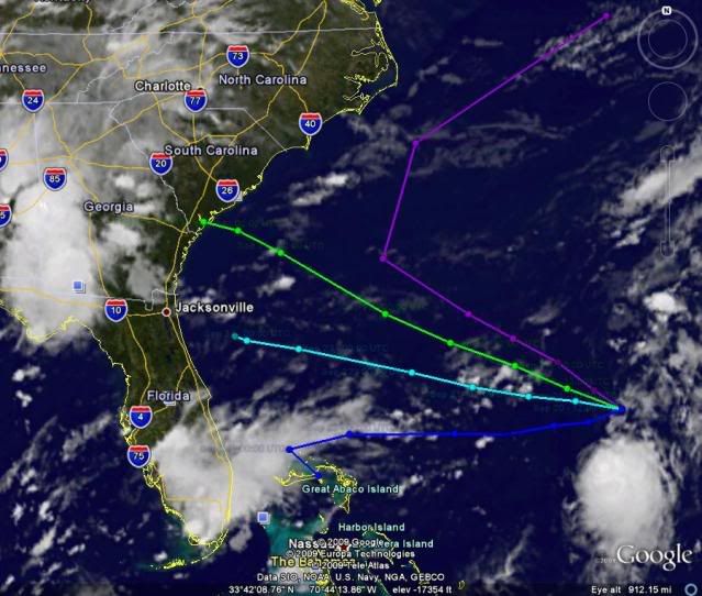
as you can see from the steering.. the ridge over the eastern US will slide east as the trough moves out which would bring about west to even possible wsw motion until the ridge slide far enough east and the system rounds the SW side of it.
0 likes

-
Aric Dunn
- Category 5
- Posts: 21238
- Age: 43
- Joined: Sun Sep 19, 2004 9:58 pm
- Location: Ready for the Chase.
- Contact:
Re: ATL: TROPICAL LOW ex-FRED (ex-07L)
cycloneye wrote:00 UTC Best Track
Wow,best track has a very long list of plots since it began as a invest and it continues to grow even more.Look at link below.
AL, 07, 2009092000, , BEST, 0, 277N, 702W, 25, 1012, LO
ftp://ftp.tpc.ncep.noaa.gov/atcf/tcweb/ ... 009.invest
yeah wow.. thats alot..
also it is moving more finally ..
past 70 west lol
0 likes
-
ozonepete
- Professional-Met

- Posts: 4743
- Joined: Mon Sep 07, 2009 3:23 pm
- Location: From Ozone Park, NYC / Now in Brooklyn, NY
Re: ATL: TROPICAL LOW ex-FRED (ex-07L)
Aric Dunn wrote:ozonepete wrote:Here's an annotated IR satellite from a little while ago. The nose of that ridge is pushing westward. If the ridge does not keep pushing westward fast enough and the trough moves away quickly enough, the low will move northwestward.
If the trough stays where it is, it will help block the low from going north, and the front edge/nose of the ridge will push it into Florida.
that is a little off ... the trough pulling is good as it will allow the ridge to build in more to the north keeping it more west..
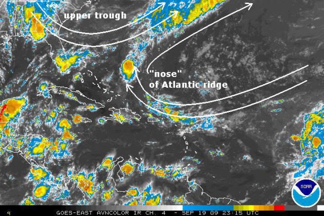
When you say the trough pulling is "good" you mean that will allow "Fred" to move westward towards Florida, right? In any case, this is the whole forecasting problem, right? We need to know the exact speed and direction of the movement of the trough and the ridge, and we don't for sure; the models vary somewhat. But the trough pulling out is no good for westward motion if the ridge stops building in. I don't see which of a few different scenarios is going to play out - it's way too close to be very confident right now. That was just to explain why the GFS is trending towards the Carolinas.
0 likes
-
Aric Dunn
- Category 5
- Posts: 21238
- Age: 43
- Joined: Sun Sep 19, 2004 9:58 pm
- Location: Ready for the Chase.
- Contact:
Re: ATL: TROPICAL LOW ex-FRED (ex-07L)
ozonepete wrote:Aric Dunn wrote:ozonepete wrote:Here's an annotated IR satellite from a little while ago. The nose of that ridge is pushing westward. If the ridge does not keep pushing westward fast enough and the trough moves away quickly enough, the low will move northwestward.
If the trough stays where it is, it will help block the low from going north, and the front edge/nose of the ridge will push it into Florida.
that is a little off ... the trough pulling is good as it will allow the ridge to build in more to the north keeping it more west..
When you say the trough pulling is "good" you mean that will allow "Fred" to move westward towards Florida, right? In any case, this is the whole forecasting problem, right? We need to know the exact speed and direction of the movement of the trough and the ridge, and we don't for sure; the models vary somewhat. But the trough pulling out is no good for westward motion if the ridge stops building in. I don't see which of a few different scenarios is going to play out - it's way too close to be very confident right now. That was just to explain why the GFS is trending towards the Carolinas.
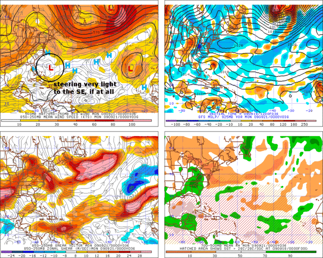
Right ... but we no its placement now.. and where you put the trough is in the middle of the ridge is what i was really pointing out... the image i posted above shows the steering.. and when i say its motion will be west to possible wsw that is starting and may last for at least 24 hours. the ridge will slide east but its still building southerly .. thats clear when you look at the lowlevel flow over cetral florida north
only NE winds throughout that region. so in the short term west to wsw is likely..
0 likes
-
ozonepete
- Professional-Met
- Posts: 4743
- Joined: Mon Sep 07, 2009 3:23 pm
- Location: From Ozone Park, NYC / Now in Brooklyn, NY
Re: ATL: TROPICAL LOW ex-FRED (ex-07L)
Aric Dunn wrote:
Right ... but we no its placement now.. and where you put the trough is in the middle of the ridge is what i was really pointing out... the image i posted above shows the steering.. and when i say its motion will be west to possible wsw that is starting and may last for at least 24 hours. the ridge will slide east but its still building southerly .. thats clear when you look at the lowlevel flow over cetral florida north
only NE winds throughout that region. so in the short term west to wsw is likely..
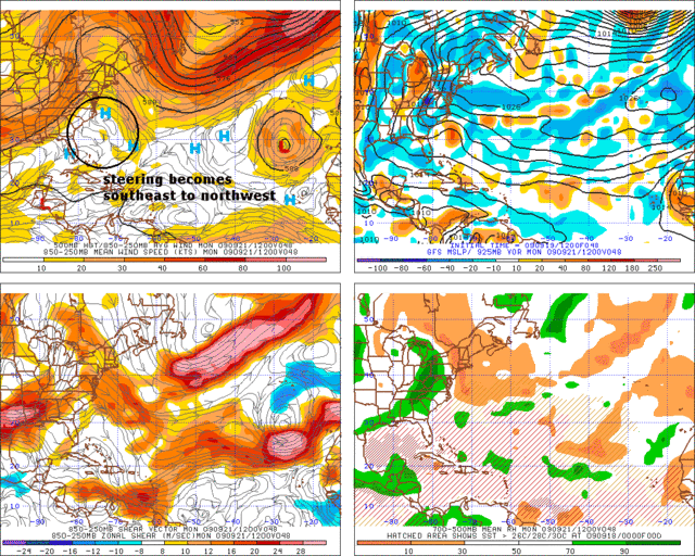
I placed the trough there because I was looking at all levels. That CIMSS chart shows 700-850mb (lower layer only) and shows the current situation, not the forecast. Yeah, lol, I know that's where the circulation is right now. But if convection builds we'll need to look at deeper steering, right?
Here's the GFS tropical model forecast for steering for tomorrow night (southeast or little motion) and Monday morning (to the northwest). It's the 850-250mb averaged layer. For the shallower layers, the GFS and NOGAPS show the same. Only the CMC forecast for the shallow layer (700-850mb) takes it west.
0 likes
-
Aric Dunn
- Category 5
- Posts: 21238
- Age: 43
- Joined: Sun Sep 19, 2004 9:58 pm
- Location: Ready for the Chase.
- Contact:
Re: ATL: TROPICAL LOW ex-FRED (ex-07L)
ozonepete wrote:Aric Dunn wrote:
Right ... but we no its placement now.. and where you put the trough is in the middle of the ridge is what i was really pointing out... the image i posted above shows the steering.. and when i say its motion will be west to possible wsw that is starting and may last for at least 24 hours. the ridge will slide east but its still building southerly .. thats clear when you look at the lowlevel flow over cetral florida north
only NE winds throughout that region. so in the short term west to wsw is likely..
I placed the trough there because I was looking at all levels. That CIMSS chart shows 700-850mb (lower layer only) and shows the current situation, not the forecast. Yeah, lol, I know that's where the circulation is right now. But if convection builds we'll need to look at deeper steering, right?
Here's the GFS tropical model forecast for steering for tomorrow night (southeast or little motion) and Monday morning (to the northwest). It's the 850-250mb averaged layer. For the shallower layers, the GFS and NOGAPS show the same. Only the CMC forecast for the shallow layer (700-850mb) takes it west.
well if it were truly a deep system i still see steering in layers in the same general west to wsw for the next 12 to 24 hours then as the ridge slides east a west to west north motion will follow.. the gfdl and hwrf from the 12z are good
0 likes
-
ozonepete
- Professional-Met
- Posts: 4743
- Joined: Mon Sep 07, 2009 3:23 pm
- Location: From Ozone Park, NYC / Now in Brooklyn, NY
Re: ATL: TROPICAL LOW ex-FRED (ex-07L)
Aric Dunn wrote:well if it were truly a deep system i still see steering in layers in the same general west to wsw for the next 12 to 24 hours then as the ridge slides east a west to west north motion will follow.. the gfdl and hwrf from the 12z are good
Yeah, once again, Aric, I was just trying to explain where the GFS and that pro met AJC3 were coming from. I don't necessarily agree with them - I'm on the fence right now. One thing I know for sure - you know your stuff really well and I pay close attention to everything you write. And I enjoy it.
0 likes
-
Aric Dunn
- Category 5
- Posts: 21238
- Age: 43
- Joined: Sun Sep 19, 2004 9:58 pm
- Location: Ready for the Chase.
- Contact:
Re: ATL: TROPICAL LOW ex-FRED (ex-07L)
ozonepete wrote:Aric Dunn wrote:well if it were truly a deep system i still see steering in layers in the same general west to wsw for the next 12 to 24 hours then as the ridge slides east a west to west north motion will follow.. the gfdl and hwrf from the 12z are good
Yeah, once again, Aric, I was just trying to explain where the GFS and that pro met AJC3 were coming from. I don't necessarily agree with them - I'm on the fence right now. One thing I know for sure - you know your stuff really well and I pay close attention to everything you write. And I enjoy it.
No worries.. no need to be on fence its just a discussion
the problem is the models have been to quick the last few days to kick out the ridge. they dont do well with blocking patterns.. Im not sure if the promets are basing their forecast solely on the models. But if they are i would bet there forecast will change soon
maybe we just off in timing.. my forecast is only for the next 12 to 24 hours.. anything past that right now is just going to change a lot since we dont know how organized it will become, if it makes into the better shear environment or not.. more time more time .. dang it i have given this things a week lol
Last edited by Aric Dunn on Sat Sep 19, 2009 9:02 pm, edited 1 time in total.
0 likes
-
sfwx

- Category 1

- Posts: 371
- Age: 60
- Joined: Thu Sep 04, 2003 1:53 pm
- Location: Rural St. Lucie County, Fl
Re: ATL: TROPICAL LOW ex-FRED (ex-07L)
jlauderdal wrote:webke wrote:So since the models and everyone that always seems to know what they are talking about, does this mean that the swirl will not be pulling a recurve up to the Carolinas
i am sounding the all clear for your location, enjoy
HMMMMMMMMMMMMMMMMMMMMMMMMMMMMMMM...
0 likes

Re: ATL: TROPICAL LOW ex-FRED (ex-07L)
Its looking less likely that S Florida will have to wory about the Ex Fred swirl.Maybe the Carolina's will deal with Fred.
0 likes
-
Blown Away

- S2K Supporter

- Posts: 10253
- Joined: Wed May 26, 2004 6:17 am
Re: ATL: TROPICAL LOW ex-FRED (ex-07L)
boca wrote:Its looking less likely that S Florida will have to wory about the Ex Fred swirl.Maybe the Carolina's will deal with Fred.
The key is the NWS's have not once predicted Fred to redevelop and it seems the shallow Bams were taking Fred NW and the deep Bams were more W. So I think maybe a deeper Fred goes W and a shallow Fred goes NW.
0 likes
Re: ATL: TROPICAL LOW ex-FRED (ex-07L)
Blown_away wrote:boca wrote:Its looking less likely that S Florida will have to wory about the Ex Fred swirl.Maybe the Carolina's will deal with Fred.
The key is the NWS's have not once predicted Fred to redevelop and it seems the shallow Bams were taking Fred NW and the deep Bams were more W. So I think maybe a deeper Fred goes W and a shallow Fred goes NW.
Problem with Fred is that he can't get his act together and deepen.
0 likes
-
Blown Away
- S2K Supporter
- Posts: 10253
- Joined: Wed May 26, 2004 6:17 am
Re: ATL: TROPICAL LOW ex-FRED (ex-07L)
boca wrote:Blown_away wrote:boca wrote:Its looking less likely that S Florida will have to wory about the Ex Fred swirl.Maybe the Carolina's will deal with Fred.
The key is the NWS's have not once predicted Fred to redevelop and it seems the shallow Bams were taking Fred NW and the deep Bams were more W. So I think maybe a deeper Fred goes W and a shallow Fred goes NW.
Problem with Fred is that he can't get his act together and deepen.
I agree and I think that's why the NWS's are going w/ remnants not redeveloped Fred going to Carolina's.
0 likes
Re: ATL: TROPICAL LOW ex-FRED (ex-07L)
Blown_away while we watch Fred fall aprt again check out the 18GFS run at 348hrs in their latest fantasy storm in the W Caribbean.
0 likes
-
wxman57

- Moderator-Pro Met

- Posts: 23172
- Age: 68
- Joined: Sat Jun 21, 2003 8:06 pm
- Location: Houston, TX (southwest)
Re: ATL: TROPICAL LOW ex-FRED (ex-07L)
Pressure near what's left of Fred's LLC (not much there) are now 1016mb and rising. I don't think it'll recover this time. Southwesterly wind shear starts in another degree or two to the west-northwest. Hopefully, all that's left by morning is a little low-level vorticity.
0 likes
-
Blown Away
- S2K Supporter
- Posts: 10253
- Joined: Wed May 26, 2004 6:17 am
Re: ATL: TROPICAL LOW ex-FRED (ex-07L)
boca wrote:Blown_away while we watch Fred fall aprt again check out the 18GFS run at 348hrs in their latest fantasy storm in the W Caribbean.
348 is over Cuba and 384 is over SFL! Time of the year is right so let's see if future runs keep developing this system.
0 likes
-
wxman57
- Moderator-Pro Met
- Posts: 23172
- Age: 68
- Joined: Sat Jun 21, 2003 8:06 pm
- Location: Houston, TX (southwest)
Re: ATL: TROPICAL LOW ex-FRED (ex-07L)
Blown_away wrote:boca wrote:Blown_away while we watch Fred fall aprt again check out the 18GFS run at 348hrs in their latest fantasy storm in the W Caribbean.
348 is over Cuba and 384 is over SFL! Time of the year is right so let's see if future runs keep developing this system.
I'm warning our clients there right away. Never known the 18Z 384hr map to be wrong...
0 likes
-
Blown Away
- S2K Supporter
- Posts: 10253
- Joined: Wed May 26, 2004 6:17 am
Re: ATL: TROPICAL LOW ex-FRED (ex-07L)
wxman57 wrote:Pressure near what's left of Fred's LLC (not much there) are now 1016mb and rising. I don't think it'll recover this time. Southwesterly wind shear starts in another degree or two to the west-northwest. Hopefully, all that's left by morning is a little low-level vorticity.
Wxman57 you are such a buzz kill!! j/k I agree this might be the end but I would not be surprised to find a decent circulation tomorrow.
0 likes
Who is online
Users browsing this forum: No registered users and 42 guests