ATL: TROPICAL LOW ex-FRED (ex-07L)
Moderator: S2k Moderators


-
Stephanie

- S2K Supporter

- Posts: 23843
- Age: 63
- Joined: Thu Feb 06, 2003 9:53 am
- Location: Glassboro, NJ
Re: ATL: TROPICAL LOW ex-FRED (ex-07L)
Emmett_Brown wrote:xironman wrote:This is where I see the llc in the visible, probably a bit different from most
I agree that this is the most likely center. Since it is elongated N to S, it is hard to say, but thats where my eye goes first. The convection to the south is dissipating, and as soon as it clears, we should know for sure.

BUH BYE Freddie!! Your 15 minutes are up (I hope).
0 likes
-
Shewtinstar
- Tropical Low

- Posts: 32
- Joined: Wed Aug 26, 2009 10:01 am


-
jaxfladude
- Category 5

- Posts: 1249
- Joined: Wed Aug 24, 2005 9:36 pm
- Location: Jacksonville, Fla

Re:
Aric Dunn wrote:about the only thing that could happen is the center try to reform a little north closer to that convection and tighten up again for the 4 time now.. and the ridge will have built in later today so a west motion should resume.. then who knows maybe another 2 days of swirl watching.. lol
Oh dear, if the ridge is supposed to build in later today, and this thing turn west, then I think we'll have to keep watching this frustrating thing.
Why do I say this?
Because the closeup visible images show that the circulation, after nearly falling apart this morning, appears to be starting to become better defined again.
Perhaps the ridge should ease off and let fred out of his misery, to be snatched by the trough.
0 likes
-
Aric Dunn
- Category 5
- Posts: 21238
- Age: 43
- Joined: Sun Sep 19, 2004 9:58 pm
- Location: Ready for the Chase.
- Contact:
Re:
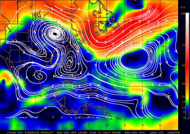
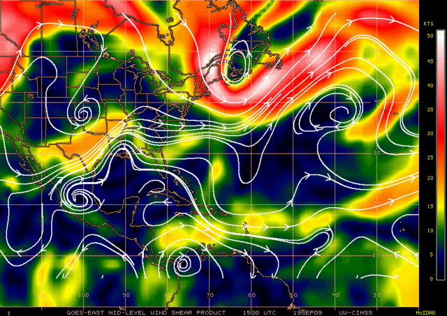
gatorcane wrote:Ex-Fred is just east of much better upper-level winds as shown by the CIMSS wind shear charts:
[img][/img]
[img][/img]
well according to the gfs.. if it decided to stay in the same spot for some dumb reason then the upper environment becomes much better in 36 to 48 hours.. but since it should west to wsw would be in a better one sooner..
but who knows.. lol Time is quickly running out.

0 likes
Re:
Fred (ex-fred) is not the one who keeps changing his mind....it is the folks (men and women) on this board who have had to constantly change their definitive forecasts and views on this storm.....keep in mind, this was a system that was never supposed to get past 35W, never going to develop with the 'wall of shear' in the atlantic, and never going to be even something that could pose a potential threat to the islands and the u.s. This was a shut case before he even got named.
The first 20 pages of this thread are interesting...even at times hilarious to read now.....almost every forecast, opinion, 'gut feeling' on what this storm would or would not do has turned out to be wrong in terms of the actual track, intensity, steering patterns, etc. There was maybe one lone voice saying that this could actually....even in remnant form.....track as far west as the bahamas and the u.s.....and that was ozonepete. He was the only one even mentioning that before the system was even a hurricane on labor day. The lone voice of reason so early on with Fred!
The first 20 pages of this thread are interesting...even at times hilarious to read now.....almost every forecast, opinion, 'gut feeling' on what this storm would or would not do has turned out to be wrong in terms of the actual track, intensity, steering patterns, etc. There was maybe one lone voice saying that this could actually....even in remnant form.....track as far west as the bahamas and the u.s.....and that was ozonepete. He was the only one even mentioning that before the system was even a hurricane on labor day. The lone voice of reason so early on with Fred!
Shewtinstar wrote:Geez, he's here, he's gone, he's here, he's gone. Fred is worse than a woman when it comes to making up his mind. And I was so excited this morning.
0 likes
-
Stephanie
- S2K Supporter
- Posts: 23843
- Age: 63
- Joined: Thu Feb 06, 2003 9:53 am
- Location: Glassboro, NJ
Re:
jaxfladude wrote:Thread lock and send it to the archives?
Are you saying that so Fred finally does die?
jinflt - it just goes to show you how much more we have to learn about the weather.
0 likes
-
ozonepete
- Professional-Met

- Posts: 4743
- Joined: Mon Sep 07, 2009 3:23 pm
- Location: From Ozone Park, NYC / Now in Brooklyn, NY
Re: ATL: TROPICAL LOW ex-FRED (ex-07L)
If you put together everything being said here, it all points to Fred still not dead. It's being elongated because its at the nose of that ridge building in towards Florida, with mid-level winds from the west on the north side and mid-level winds from the north and east on its south side. That's why storms on the south side are getting sheared off to the southwest and yet the northern storms, as soon as they grow into the mid-levels, are now getting blown to the east. And everyone's drawing two circles in two different places because there are two centers trying to form. It's really hard to tell which one might prevail. That's probably why Miami and Key West disagree: The northern center would probably go to the Carolinas and the southern one to south Florida. The models still can't get a handle on this because it's been such a small center and now to further complicate things it's under very light steering winds. It's pretty much too mesoscale for the models to handle well. Only visual obs are going to tell us if one center or none at all prevails.
So we could say it's dead, but I figure we know better by now than to stop looking yet...

Had to add an arrow...
So we could say it's dead, but I figure we know better by now than to stop looking yet...
Had to add an arrow...
Last edited by ozonepete on Sat Sep 19, 2009 1:02 pm, edited 1 time in total.
0 likes
Re: ATL: TROPICAL LOW ex-FRED (ex-07L)
Aric Dunn wrote:well according to the gfs.. if it decided to stay in the same spot for some dumb reason then the upper environment becomes much better in 36 to 48 hours.. but since it should west to wsw would be in a better one sooner..
but who knows.. lol Time is quickly running out.
I have been watching this waste of time all morning. It has basically come to a stall around 70W.
0 likes
Re: ATL: TROPICAL LOW ex-FRED (ex-07L)
ozonepete wrote:And everyone's drawing two circles in two different places because there are two centers trying to form.
I think the north one is the one to watch. It seems to have a lot more movement in the lower level clouds.
0 likes
-
Emmett_Brown

- Category 5
- Posts: 1433
- Joined: Wed Aug 24, 2005 9:10 pm
- Location: Sarasota FL
Re: ATL: TROPICAL LOW ex-FRED (ex-07L)
In the past, I would have written a system like this off permanently, but TD 10/12 of 2005 taught us anything is possible, even if that type of event is indeed extremely rare. Indeed, Fred is still there, just barely. Who wants to volunteer to watch him for the rest of us and wake us up when he finally pops?
0 likes
-
Emmett_Brown
- Category 5
- Posts: 1433
- Joined: Wed Aug 24, 2005 9:10 pm
- Location: Sarasota FL
Re: ATL: TROPICAL LOW ex-FRED (ex-07L)
xironman wrote:ozonepete wrote:And everyone's drawing two circles in two different places because there are two centers trying to form.
I think the north one is the one to watch. It seems to have a lot more movement in the lower level clouds.
I agree. The north is where the action is, and where some convergence exists. As the high builds in from the N later, we should see the N center start to grow.
0 likes
-
ozonepete
- Professional-Met
- Posts: 4743
- Joined: Mon Sep 07, 2009 3:23 pm
- Location: From Ozone Park, NYC / Now in Brooklyn, NY
Re: Re:
jinftl wrote:Fred (ex-fred) is not the one who keeps changing his mind....it is the folks (men and women) on this board who have had to constantly change their definitive forecasts and views on this storm.....keep in mind, this was a system that was never supposed to get past 35W, never going to develop with the 'wall of shear' in the atlantic, and never going to be even something that could pose a potential threat to the islands and the u.s. This was a shut case before he even got named.
The first 20 pages of this thread are interesting...even at times hilarious to read now.....almost every forecast, opinion, 'gut feeling' on what this storm would or would not do has turned out to be wrong in terms of the actual track, intensity, steering patterns, etc. There was maybe one lone voice saying that this could actually....even in remnant form.....track as far west as the bahamas and the u.s.....and that was ozonepete. He was the only one even mentioning that before the system was even a hurricane on labor day. The lone voice of reason so early on with Fred!Shewtinstar wrote:Geez, he's here, he's gone, he's here, he's gone. Fred is worse than a woman when it comes to making up his mind. And I was so excited this morning.
thanks jinftl, but I think it was also Aric. He's the one who spotted the little swirl on the Puerto Rico visible loop and pointed it out when everyone else had pronounced it dead. Although, lol, as you said, everyone's been pronouncing it dead every day for a couple of weeks.
0 likes
-
ozonepete
- Professional-Met
- Posts: 4743
- Joined: Mon Sep 07, 2009 3:23 pm
- Location: From Ozone Park, NYC / Now in Brooklyn, NY
Re: ATL: TROPICAL LOW ex-FRED (ex-07L)
Emmett_Brown wrote:xironman wrote:ozonepete wrote:And everyone's drawing two circles in two different places because there are two centers trying to form.
I think the north one is the one to watch. It seems to have a lot more movement in the lower level clouds.
I agree. The north is where the action is, and where some convergence exists. As the high builds in from the N later, we should see the N center start to grow.
I agree.
0 likes
-
HURAKAN

- Professional-Met
- Posts: 46084
- Age: 39
- Joined: Thu May 20, 2004 4:34 pm
- Location: Key West, FL
- Contact:
Re: ATL: TROPICAL LOW ex-FRED (ex-07L)
641
ABNT20 KNHC 191732
TWOAT
TROPICAL WEATHER OUTLOOK
NWS TPC/NATIONAL HURRICANE CENTER MIAMI FL
200 PM EDT SAT SEP 19 2009
FOR THE NORTH ATLANTIC...CARIBBEAN SEA AND THE GULF OF MEXICO...
A SURFACE TROUGH ASSOCIATED WITH THE REMNANTS OF FRED IS LOCATED
ABOUT 475 MILES EAST-NORTHEAST OF THE NORTHWESTERN BAHAMAS AND IS
PRODUCING DISORGANIZED SHOWERS AND THUNDERSTORMS. THIS SYSTEM HAS
BECOME LESS ORGANIZED DURING THE DAY AND THE RECONNAISSANCE MISSION
SCHEDULED FOR THIS AFTERNOON HAS BEEN CANCELED. THERE IS A LOW
CHANCE...LESS THAN 30 PERCENT...OF THIS SYSTEM BECOMING A TROPICAL
CYCLONE DURING THE NEXT 48 HOURS AS IT MOVES SLOWLY TOWARD THE
WEST-NORTHWEST.
SHOWER AND THUNDERSTORM ACTIVITY HAS DIMINISHED IN ASSOCIATION WITH
A BROAD AREA OF LOW PRESSURE CENTERED ABOUT 1200 MILES EAST OF THE
WINDWARD ISLANDS. HOWEVER...THIS SYSTEM STILL HAS THE POTENTIAL TO
BECOME A TROPICAL DEPRESSION OVER THE NEXT DAY OR TWO AS IT MOVES
TOWARD THE WEST-NORTHWEST AT AROUND 10 MPH. THERE IS A MEDIUM
CHANCE...30 TO 50 PERCENT...OF THIS SYSTEM BECOMING A TROPICAL
CYCLONE DURING THE NEXT 48 HOURS.
AN AREA OF DISTURBED WEATHER LOCATED A COUPLE HUNDRED MILES
NORTHEAST OF THE CAPE VERDE ISLANDS HAS BECOME LESS ORGANIZED OVER
THE PAST SEVERAL HOURS. DEVELOPMENT OF THIS SYSTEM IS NOT
ANTICIPATED AS IT MOVES TOWARD THE WEST-NORTHWEST AT ABOUT 10 MPH.
THERE IS A LOW CHANCE...LESS THAN 30 PERCENT...OF THIS SYSTEM
BECOMING A TROPICAL CYCLONE DURING THE NEXT 48 HOURS.
ELSEWHERE...TROPICAL CYCLONE FORMATION IS NOT EXPECTED DURING THE
NEXT 48 HOURS.
$$
FORECASTER BLAKE
0 likes
-
ozonepete
- Professional-Met
- Posts: 4743
- Joined: Mon Sep 07, 2009 3:23 pm
- Location: From Ozone Park, NYC / Now in Brooklyn, NY
Re: ATL: TROPICAL LOW ex-FRED (ex-07L)
Emmett_Brown wrote:xironman wrote:ozonepete wrote:And everyone's drawing two circles in two different places because there are two centers trying to form.
I think the north one is the one to watch. It seems to have a lot more movement in the lower level clouds.
I agree. The north is where the action is, and where some convergence exists. As the high builds in from the N later, we should see the N center start to grow.
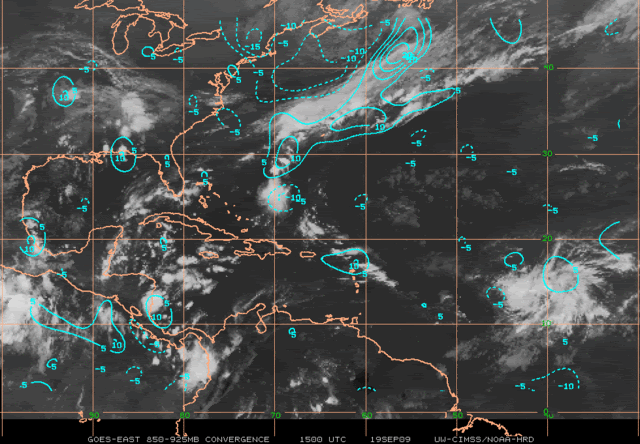
Here's the last convergence chart from CIMSS, Emmet. You are exactly right.
0 likes
Who is online
Users browsing this forum: No registered users and 11 guests