
Who was it who said, "There's no there there."?
I think whoever it was, they were talking about Cleveland. But it could be said of Fred.
ATL: TROPICAL LOW ex-FRED (ex-07L)
Moderator: S2k Moderators
-
hurricanetrack

- HurricaneTrack.com

- Posts: 1781
- Joined: Tue Dec 02, 2003 10:46 pm
- Location: Wilmington, NC
- Contact:

-
hurricanetrack
- HurricaneTrack.com
- Posts: 1781
- Joined: Tue Dec 02, 2003 10:46 pm
- Location: Wilmington, NC
- Contact:
There is really here plus a "T". And Fred is still there or here, if you were there.
Sorry, it is getting ridiculous how long this system has been around and commanded so much of our time when it has really been a bunch of nothing. Kind of makes you want to see it come back as a tropical storm at least and hit somewhere just to make it all worth while. At least I feel that way....we'll see. Satellite eclipse time, nice.
Sorry, it is getting ridiculous how long this system has been around and commanded so much of our time when it has really been a bunch of nothing. Kind of makes you want to see it come back as a tropical storm at least and hit somewhere just to make it all worth while. At least I feel that way....we'll see. Satellite eclipse time, nice.
0 likes
-
Aric Dunn
- Category 5
- Posts: 21238
- Age: 43
- Joined: Sun Sep 19, 2004 9:58 pm
- Location: Ready for the Chase.
- Contact:
Re:
hurricanetrack wrote:There is really here plus a "T". And Fred is still there or here, if you were there.
Sorry, it is getting ridiculous how long this system has been around and commanded so much of our time when it has really been a bunch of nothing. Kind of makes you want to see it come back as a tropical storm at least and hit somewhere just to make it all worth while. At least I feel that way....we'll see. Satellite eclipse time, nice.
yeah for sure .. it has been a taxing system to watch ...
stupid sat eclipse..
0 likes
-
Aric Dunn
- Category 5
- Posts: 21238
- Age: 43
- Joined: Sun Sep 19, 2004 9:58 pm
- Location: Ready for the Chase.
- Contact:
Thought this was interesting .. and makes ense if you believe in superstition .. lol
Retirement
See also: List of retired Atlantic hurricane names
Due to the damage and deaths on Bermuda, the name Fabian was retired in the spring of 2004 and will never again be used for an Atlantic hurricane. As a result, the Bermuda Weather Service allowed residents to suggest a replacement name, with the only rule being the name had to be a male name beginning with the letter "F", able to be easily pronounced, and not currently in use. The service received a list of over 30 names, including Forrest and Frodo, after the character in The Lord of the Rings.[51] The Bermuda Weather Service sent three names to the World Meteorological Organization; Fred, Ford, and Flynn.[52] The World Meteorological Organization ultimately replaced Fabian with Fred to be on the list for the 2009 season.[25]
\
0 likes
-
HURAKAN

- Professional-Met

- Posts: 46086
- Age: 38
- Joined: Thu May 20, 2004 4:34 pm
- Location: Key West, FL
- Contact:
497
ABNT20 KNHC 190517
TWOAT
TROPICAL WEATHER OUTLOOK
NWS TPC/NATIONAL HURRICANE CENTER MIAMI FL
200 AM EDT SAT SEP 19 2009
FOR THE NORTH ATLANTIC...CARIBBEAN SEA AND THE GULF OF MEXICO...
A SMALL LOW PRESSURE AREA...ASSOCIATED WITH THE REMNANTS OF FRED...
CENTERED ABOUT 500 MILES EAST OF THE NORTHWESTERN BAHAMAS IS
PRODUCING MINIMAL SHOWER AND THUNDERSTORM ACTIVITY. UPPER-LEVEL
WINDS COULD BECOME A LITTLE MORE FAVORABLE FOR SOME DEVELOPMENT
DURING THE NEXT DAY OR TWO AS THE SYSTEM MOVES WEST-NORTHWESTWARD
AT 10 TO 15 MPH. THERE IS A LOW CHANCE...LESS THAN 30 PERCENT...OF
THIS SYSTEM BECOMING A TROPICAL CYCLONE DURING THE NEXT 48 HOURS.
SHOWER ACTIVITY ASSOCIATED WITH A BROAD AREA OF LOW PRESSURE
CENTERED ABOUT MIDWAY BETWEEN AFRICA AND THE LESSER ANTILLES SHOWS
SOME SIGNS OF ORGANIZATION. THIS SYSTEM HAS THE POTENTIAL FOR SLOW
DEVELOPMENT OVER THE NEXT COUPLE OF DAYS AS IT MOVES TOWARD THE
WEST-NORTHWEST AT AROUND 10 MPH. THERE IS A MEDIUM CHANCE...30 TO
50 PERCENT...OF THIS SYSTEM BECOMING A TROPICAL CYCLONE DURING THE
NEXT 48 HOURS.
ELSEWHERE...TROPICAL CYCLONE FORMATION IS NOT EXPECTED DURING THE
NEXT 48 HOURS.
$$
FORECASTER AVILA
0 likes

-
Aric Dunn
- Category 5
- Posts: 21238
- Age: 43
- Joined: Sun Sep 19, 2004 9:58 pm
- Location: Ready for the Chase.
- Contact:
Re: ATL: TROPICAL LOW ex-FRED (ex-07L)
One, two, Freddy's coming for you,
Three, four, better lock your door,
Five, six, grab your crucifix,
Seven, eight, better stay up late,
Nine, ten, Freddy's back again.

Three, four, better lock your door,
Five, six, grab your crucifix,
Seven, eight, better stay up late,
Nine, ten, Freddy's back again.
0 likes
-
jlauderdal
- S2K Supporter

- Posts: 7240
- Joined: Wed May 19, 2004 5:46 am
- Location: NE Fort Lauderdale
- Contact:
Re: ATL: TROPICAL LOW ex-FRED (ex-07L)
Aric Dunn wrote:One, two, Freddy's coming for you,
Three, four, better lock your door,
Five, six, grab your crucifix,
Seven, eight, better stay up late,
Nine, ten, Freddy's back again.
doesn't look naked anymore, does it
0 likes
-
deltadog03

- Professional-Met
- Posts: 3580
- Joined: Tue Jul 05, 2005 6:16 pm
- Location: Macon, GA
-
jlauderdal
- S2K Supporter
- Posts: 7240
- Joined: Wed May 19, 2004 5:46 am
- Location: NE Fort Lauderdale
- Contact:
Re:
deltadog03 wrote:This little booger is showing a nice blow up of storms right now. Shear looks a little bit less.
the N-S orientation inst exactly the prettiest but at least we have some convection to work with to get this thing a jump start today
0 likes


-
Emmett_Brown

- Category 5
- Posts: 1433
- Joined: Wed Aug 24, 2005 9:10 pm
- Location: Sarasota FL

-
Emmett_Brown
- Category 5
- Posts: 1433
- Joined: Wed Aug 24, 2005 9:10 pm
- Location: Sarasota FL
Re: ATL: TROPICAL LOW ex-FRED (ex-07L)
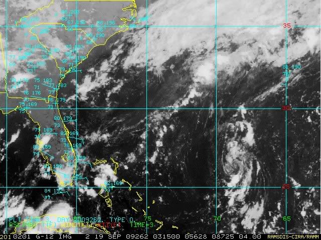
So far, while the northerly shear is still there, it hasn't torn this burst away. The burst is more circular than yesterday's burst:

0 likes
-
jlauderdal
- S2K Supporter
- Posts: 7240
- Joined: Wed May 19, 2004 5:46 am
- Location: NE Fort Lauderdale
- Contact:
Re: ATL: TROPICAL LOW ex-FRED (ex-07L)
Emmett_Brown wrote:Convective burst looking a bit more circular:
that is looking much better, at this rate we will get a recon flight, they should have plenty of budget left to fuel up the planes, use it or lose it in the world of govt budgets
0 likes
-
deltadog03
- Professional-Met
- Posts: 3580
- Joined: Tue Jul 05, 2005 6:16 pm
- Location: Macon, GA
Who is online
Users browsing this forum: No registered users and 42 guests