
ATL : TROPICAL DEPRESSION ERIKA (06L)
Moderator: S2k Moderators
-
deltadog03

- Professional-Met

- Posts: 3580
- Joined: Tue Jul 05, 2005 6:16 pm
- Location: Macon, GA
-
lrak

- S2K Supporter

- Posts: 1770
- Age: 59
- Joined: Thu Jun 21, 2007 2:48 pm
- Location: Corpus Christi, TX
Re: ATL : TROPICAL STORM ERIKA (06L)
storms NC wrote:Here is MO ONLY this is not a NHC forcast
Well I know I will get jumped on or no one will leason to what I have to say. But I will try any how. I have two home one in NC and one in Ft Myers Fl. So I watch for either A fl hit or NC hit. But if you look at the whole piture you can see that there will a High in the Gulf and a Low on or just of the Souteast coast. So the tell me it will not move into the Gulf. A storm will move away from a high or go around it but not to it. A storm will go to a low. Every one know this but will not look past the floaters. here is a map I did and it will show where the high is now and where it will be in a few days.

if it stays weak why couldn't it go under the H pressure and hit Central America?
0 likes
-
HURAKAN

- Professional-Met
- Posts: 46084
- Age: 39
- Joined: Thu May 20, 2004 4:34 pm
- Location: Key West, FL
- Contact:
URNT15 KNHC 021848
AF309 0306A ERIKA HDOB 16 20090902
183830 1538N 05842W 8425 01586 0102 +182 +143 198037 037 039 002 00
183900 1538N 05840W 8433 01577 0105 +180 +143 199036 037 037 004 00
183930 1537N 05839W 8429 01582 0103 +183 +141 198034 035 038 004 00
184000 1536N 05838W 8434 01575 0104 +182 +140 200035 035 038 004 00
184030 1535N 05836W 8430 01582 0106 +179 +140 202036 037 039 003 00
184100 1534N 05835W 8428 01584 0109 +175 +140 200035 035 039 003 00
184130 1534N 05833W 8429 01582 0112 +172 +140 196033 034 039 003 00
184200 1533N 05832W 8429 01584 0110 +175 +140 198033 034 039 003 00
184230 1532N 05831W 8427 01588 0113 +172 +139 198034 035 040 003 00
184300 1531N 05829W 8429 01588 0119 +166 +139 197034 035 040 005 00
184330 1530N 05828W 8431 01586 0122 +164 +138 198031 031 039 006 03
184400 1529N 05827W 8422 01597 0121 +164 +136 203030 031 039 006 03
184430 1528N 05827W 8432 01585 0122 +163 +135 188028 029 039 006 00
184500 1526N 05828W 8434 01583 0121 +164 +133 182031 032 038 006 00
184530 1525N 05828W 8422 01594 0114 +174 +130 189029 030 039 007 00
184600 1523N 05828W 8433 01582 0116 +170 +128 201030 031 037 007 00
184630 1522N 05828W 8436 01581 0112 +176 +128 205031 031 040 003 00
184700 1521N 05828W 8429 01585 0110 +180 +127 210029 029 040 003 00
184730 1519N 05828W 8429 01585 0111 +177 +127 208028 028 039 004 00
184800 1518N 05828W 8429 01585 0113 +173 +128 198025 027 033 006 00
0 likes
-
jlauderdal
- S2K Supporter
- Posts: 7240
- Joined: Wed May 19, 2004 5:46 am
- Location: NE Fort Lauderdale
- Contact:
Re: ATL : TROPICAL STORM ERIKA (06L)
deltadog03 wrote:
these homemade maps some of you(not all) guys do really rule and im not being sarcastic, i would rather look at these all day long versus radar loops and IR loops, tells me more than all of that other stuff
0 likes

Re: ATL : TROPICAL STORM ERIKA (06L)
Looks to me like the LLCC is moving WSW away from the convection.
0 likes
-
Weatherboy1

- Category 5

- Posts: 1190
- Age: 50
- Joined: Mon Jul 05, 2004 1:50 pm
- Location: Jupiter/Sarasota, FL
Re: Re:
wxman57 wrote:Weatherboy1 wrote:I'm confused in general about the shear situation. I mean, isn't shear decreasing in the area (though still somewhat elevated to the NW)?
http://cimss.ssec.wisc.edu/tropic2/real ... oom=&time=
One problem, as the NHC discussion attempted to say, is that those shear charts represent too broad of a range of heights. They don't pick up on small pockets of high shear between the listed levels. So the AVERAGE shear between two levels may not be very high, but the shear across a narrow part of that broad range could be quite strong.
Okay. Thanks for the response guys...
0 likes
-
lrak
- S2K Supporter
- Posts: 1770
- Age: 59
- Joined: Thu Jun 21, 2007 2:48 pm
- Location: Corpus Christi, TX
Re: Re:
Weatherboy1 wrote:wxman57 wrote:Weatherboy1 wrote:I'm confused in general about the shear situation. I mean, isn't shear decreasing in the area (though still somewhat elevated to the NW)?
http://cimss.ssec.wisc.edu/tropic2/real ... oom=&time=
One problem, as the NHC discussion attempted to say, is that those shear charts represent too broad of a range of heights. They don't pick up on small pockets of high shear between the listed levels. So the AVERAGE shear between two levels may not be very high, but the shear across a narrow part of that broad range could be quite strong.
Okay. Thanks for the response guys...
I still can't figure out the steering flow maps...LOL. I can do taxes and help you save money though!
0 likes
-
Wx_Warrior
- Category 5
- Posts: 2718
- Joined: Thu Aug 03, 2006 3:58 pm
- Location: Beaumont, TX
Re: ATL : TROPICAL STORM ERIKA - Computer Models
EDIT: Pro met explain the latest EURO to me: EURO dissiaptes it over Puerto Rico and those Mountainous Islands...
0 likes

-
Weatherboy1
- Category 5
- Posts: 1190
- Age: 50
- Joined: Mon Jul 05, 2004 1:50 pm
- Location: Jupiter/Sarasota, FL
Re: Re:
Well, I may not be a meterologist. But I did stay at a Holiday Inn last night. Does that qualify me to forecast what'll happen with Erika? 
0 likes
-
HURAKAN
- Professional-Met
- Posts: 46084
- Age: 39
- Joined: Thu May 20, 2004 4:34 pm
- Location: Key West, FL
- Contact:
URNT15 KNHC 021858
AF309 0306A ERIKA HDOB 17 20090902
184830 1516N 05828W 8436 01578 0107 +184 +128 210025 026 035 006 00
184900 1515N 05828W 8426 01589 0108 +182 +129 205026 027 035 007 00
184930 1513N 05828W 8422 01595 0114 +174 +130 200024 025 034 006 00
185000 1512N 05828W 8425 01590 0114 +175 +131 205023 025 033 005 00
185030 1510N 05829W 8424 01596 0124 +163 +132 203022 023 035 005 00
185100 1509N 05829W 8433 01586 0128 +159 +131 208020 021 034 007 00
185130 1507N 05829W 8429 01591 0129 +158 +130 204020 021 033 006 00
185200 1506N 05829W 8426 01594 0128 +160 +128 204020 021 030 005 00
185230 1504N 05829W 8432 01589 0130 +160 +126 206020 020 029 005 00
185300 1503N 05829W 8428 01592 0131 +159 +125 206021 021 029 004 00
185330 1501N 05829W 8430 01593 0131 +157 +124 204021 021 028 004 00
185400 1500N 05829W 8430 01591 0131 +158 +124 204020 020 028 004 00
185430 1458N 05829W 8427 01597 0132 +159 +123 205019 020 028 003 00
185500 1457N 05829W 8434 01590 0135 +155 +124 202019 019 028 001 00
185530 1455N 05829W 8425 01597 0135 +155 +124 203019 020 025 002 00
185600 1454N 05830W 8428 01595 0133 +159 +124 203020 020 028 000 00
185630 1452N 05830W 8433 01590 0133 +160 +124 200020 020 027 001 00
185700 1451N 05830W 8428 01596 0133 +159 +125 200019 019 024 003 00
185730 1449N 05830W 8430 01593 0133 +160 +126 201019 019 027 000 00
185800 1448N 05830W 8431 01592 0133 +160 +127 199019 019 025 002 00
0 likes
Re: Re:
Weatherboy1 wrote:Well, I may not be a meterologist. But I did stay at a Holiday Inn last night. Does that qualify me to forecast what'll happen with Erika?
You can guess along with most of the rest of us as long as you precede your guess with the following:
The following post is NOT an official forecast and should not be used as such. It is just the opinion of the poster and may or may not be backed by sound meteorological data. It is NOT endorsed by any professional institution including storm2k.org For Official Information please refer to the NHC and NWS products.
0 likes
-
dolebot_Broward_NW
- Category 2

- Posts: 529
- Joined: Fri Sep 10, 2004 6:38 am
This outflow boundary is actually radiating from the convection at a perpendicular angle to the LLC. That's one ugly storm at present.
I'm not so sure that feature is an "outflow boundary". It's been there almost stationary all day, now its sort of wrapping back into the exposed LLC. An outflow boundary from a weakening system due to collapsing convection - typically race out of the CDO and are gone not too long after.
Maybe some other sort of boundary?
0 likes
-
otowntiger
- Category 5
- Posts: 1932
- Joined: Tue Aug 31, 2004 7:06 pm
Re: ATL : TROPICAL STORM ERIKA (06L)
lrak wrote:http://flhurricane.com/imageanimator.php?69
the last few frames show this vortex WXman and it looks like some of the rain to its east is starting to consolidate around it.
That is a a very interesting radar loop. It shows that vortex may have been rotating around a broader center but once it got right next to Guadaloupe it stopped moving and started to consolidate a little bit. The other thing it confirms is that this is one puzzling disorganized system.
0 likes
-
HURAKAN
- Professional-Met
- Posts: 46084
- Age: 39
- Joined: Thu May 20, 2004 4:34 pm
- Location: Key West, FL
- Contact:
URNT15 KNHC 021908
AF309 0306A ERIKA HDOB 18 20090902
185830 1446N 05830W 8432 01592 0133 +160 +127 198019 019 026 001 00
185900 1445N 05830W 8430 01592 0133 +160 +128 195018 018 027 001 00
185930 1443N 05830W 8429 01595 0133 +160 +128 196018 018 027 000 00
190000 1442N 05830W 8430 01593 0133 +160 +129 194018 019 026 002 00
190030 1440N 05830W 8429 01593 0132 +160 +129 193019 019 026 002 00
190100 1439N 05831W 8432 01592 0133 +160 +129 193019 019 026 002 00
190130 1437N 05831W 8428 01595 0132 +160 +129 193019 019 027 001 00
190200 1436N 05831W 8432 01591 0131 +160 +129 191020 020 027 001 00
190230 1435N 05831W 8429 01593 0131 +160 +129 192020 020 027 002 00
190300 1433N 05831W 8430 01591 0131 +160 +129 193019 019 027 000 00
190330 1432N 05831W 8430 01593 0132 +160 +129 192019 019 027 000 00
190400 1430N 05831W 8429 01592 0132 +160 +129 190019 019 026 001 00
190430 1429N 05831W 8428 01595 0132 +160 +129 196018 018 027 000 00
190500 1427N 05831W 8430 01594 0132 +160 +130 194018 018 025 001 00
190530 1426N 05831W 8429 01596 0133 +160 +130 190018 018 025 001 00
190600 1424N 05831W 8432 01592 0134 +160 +130 192017 017 026 001 03
190630 1423N 05833W 8428 01598 0135 +160 +130 190018 019 999 999 03
190700 1425N 05833W 8430 01596 0135 +160 +131 193020 021 999 999 03
190730 1426N 05832W 8433 01592 0133 +160 +132 191021 021 022 000 03
190800 1426N 05830W 8428 01597 0134 +160 +133 188021 021 026 000 03
0 likes
-
marciacubed
- S2K Supporter
- Posts: 122
- Joined: Tue Jul 22, 2003 11:52 am
- Location: Boynton Beach, Fl
- Contact:
Re: ATL : TROPICAL STORM ERIKA (06L)
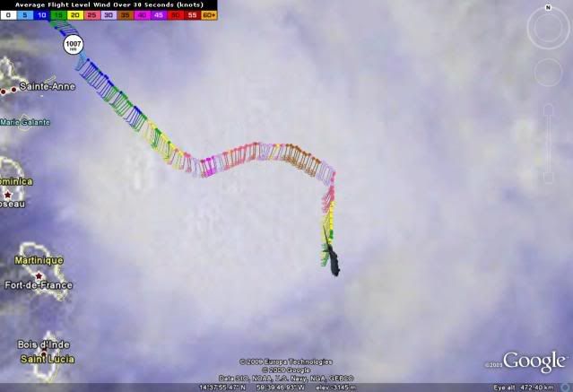
I was wondering if I was reading the recon page right. Does it say that the winds are now over 60kt ? I was just looking at the site and that is what I thought the last photo was showing. If this is true then she is strengthening am I right or am I reading it wrong. If someone answers my question, Thanks in advance.
0 likes
-
dolebot_Broward_NW
- Category 2
- Posts: 529
- Joined: Fri Sep 10, 2004 6:38 am
Re: ATL : TROPICAL STORM ERIKA (06L)
marciacubed wrote:I was wondering if I was reading the recon page right. Does it say that the winds are now over 60kt ? I was just looking at the site and that is what I thought the last photo was showing. If this is true then she is strengthening am I right or am I reading it wrong. If someone answers my question, Thanks in advance.
Typically recon samples "flight level" winds. That is winds at like 10,000 feet. These winds are usually much stronger than those at the surface (which is what the storm is rated). Usually they use something like 80% of flight level winds equal surface wind, so 60kt *0.8 = 48kt, so not quite 50kts.
0 likes
-
curtadams
- S2K Supporter
- Posts: 1122
- Joined: Sun Aug 28, 2005 7:57 pm
- Location: Orange, California
- Contact:
The vortex message did say the surface center was displaced 10 miles from the flight level center. This is probably an underestimate as the "center" is defined as the point on their run with the lowest pressure/winds. If the centers are displaced perpendicular to the run they won't notice until the cross run.
0 likes
-
wxman57

- Moderator-Pro Met

- Posts: 23172
- Age: 68
- Joined: Sat Jun 21, 2003 8:06 pm
- Location: Houston, TX (southwest)
Re: ATL : TROPICAL STORM ERIKA (06L)
New surface plot/satellite. Not a lot of obs on this one, but the 15kt southerly wind at Guadeloupe southwest of the NHC 18Z position would suggest that there is no center near 16.4N/61.3W. I think the center is the vortex SW of Guadeloupe. Just can't fine any other evidence of rotation.

0 likes
Who is online
Users browsing this forum: No registered users and 18 guests