URNT15 KNHC 021818
AF309 0306A ERIKA HDOB 13 20090902
180830 1556N 06007W 9597 00426 0075 +231 +187 194021 021 031 000 00
180900 1554N 06005W 9593 00430 0077 +228 +187 190022 023 031 000 03
180930 1553N 06004W 9594 00430 0078 +223 +187 190020 021 030 000 00
181000 1552N 06003W 9589 00436 0079 +220 +186 188019 020 030 000 00
181030 1551N 06002W 9598 00427 0079 +223 +185 193018 019 030 001 00
181100 1550N 06001W 9600 00427 0080 +223 +184 196019 021 028 002 00
181130 1549N 06000W 9594 00432 0083 +216 +184 200021 023 033 006 00
181200 1548N 05959W 9594 00433 0087 +199 +183 199022 023 037 012 00
181230 1547N 05958W 9591 00439 0087 +209 +177 193022 023 031 008 00
181300 1546N 05957W 9586 00441 0088 +209 +173 186020 022 031 005 00
181330 1545N 05956W 9601 00430 0088 +208 +170 183019 020 038 011 00
181400 1544N 05955W 9600 00430 0090 +195 +168 195020 020 047 020 00
181430 1543N 05954W 9602 00430 0090 +200 +164 197021 023 038 018 00
181500 1542N 05953W 9602 00431 0088 +216 +160 207022 023 038 013 00
181530 1541N 05952W 9594 00438 0085 +226 +159 201025 028 032 011 03
181600 1540N 05950W 9604 00427 0085 +223 +161 196023 024 032 008 03
181630 1539N 05949W 9582 00447 0086 +217 +165 191020 025 034 004 00
181700 1539N 05947W 9598 00431 0083 +225 +168 189027 028 035 000 00
181730 1538N 05946W 9598 00432 0083 +220 +171 173027 028 036 000 00
181800 1538N 05945W 9604 00423 0083 +214 +173 172027 030 039 005 03
ATL : TROPICAL DEPRESSION ERIKA (06L)
Moderator: S2k Moderators
-
wxman57

- Moderator-Pro Met

- Posts: 23172
- Age: 68
- Joined: Sat Jun 21, 2003 8:06 pm
- Location: Houston, TX (southwest)
Re: ATL : TROPICAL STORM ERIKA (06L)
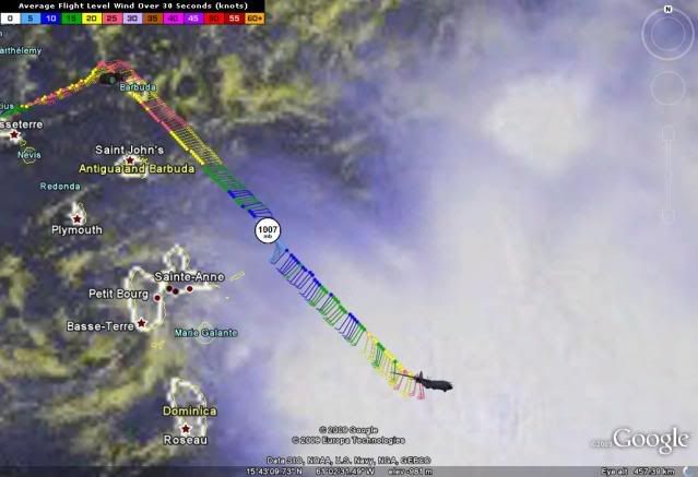
Here's another shot with a few more obs. Plane reported a VDM near 16.6N/60.8W. Doesn't match what surface obs there are well, but the center could be an ellipse stretching from SW of Guadeloupe where the vortex is seen on satellite to NE of Guadeloupe.

0 likes

Re: ATL : TROPICAL STORM ERIKA - Computer Models
Boy, what is wrong with the HWRF model this year. Last year this model was praised as the replacement for the GFDL model. So far this year it's had one of the worst track errors and has been way too agressive on intensity. It's also had a rather noticeable right-hand bias. I think someone must have taken the changes from last years CMC and put them in the HWRF. 
0 likes


-
Evil Jeremy

- S2K Supporter

- Posts: 5463
- Age: 32
- Joined: Mon Apr 10, 2006 2:10 pm
- Location: Los Angeles, CA
Re: ATL : TROPICAL STORM ERIKA - Computer Models
Both the new CMC and the new UKMET keep this west and dissipate it shortly. Hmm...
0 likes
Re: ATL : TROPICAL STORM ERIKA - Computer Models
this just goes to show models dont know either,,,yesterday it was strong building moving along today they cant even find anything. thats the joy of weather NO ONE knows what gonna happend next with it....that is why it interest me so much and probably most of yall
0 likes
-
HURAKAN

- Professional-Met

- Posts: 46084
- Age: 39
- Joined: Thu May 20, 2004 4:34 pm
- Location: Key West, FL
- Contact:
URNT15 KNHC 021828
AF309 0306A ERIKA HDOB 14 20090902
181830 1537N 05944W 9597 00428 0081 +207 +174 184031 034 040 006 00
181900 1536N 05942W 9598 00428 0081 +210 +172 174030 030 041 006 00
181930 1535N 05941W 9587 00437 0080 +217 +170 180031 032 042 005 00
182000 1535N 05940W 9595 00431 0081 +223 +169 165033 034 041 004 03
182030 1535N 05938W 9599 00427 0079 +227 +169 167037 039 037 002 03
182100 1535N 05937W 9605 00423 0092 +220 +171 161040 042 042 003 00
182130 1536N 05935W 9587 00434 0082 +227 +172 163042 044 039 003 00
182200 1536N 05934W 9588 00431 0072 +229 +172 169040 041 040 001 00
182230 1537N 05932W 9600 00447 0098 +225 +173 169041 044 038 002 00
182300 1537N 05931W 9586 00430 0072 +215 +175 172032 033 039 001 00
182330 1538N 05929W 9599 00447 0094 +220 +176 168034 035 039 002 00
182400 1538N 05928W 9592 00425 0070 +225 +175 164031 033 039 000 00
182430 1539N 05926W 9593 00425 0079 +228 +176 169027 029 035 002 00
182500 1539N 05925W 9593 00425 0082 +234 +176 169027 028 033 000 00
182530 1540N 05923W 9593 00425 0069 +236 +177 167024 025 032 001 00
182600 1540N 05922W 9594 00423 0091 +240 +179 175025 027 033 001 00
182630 1541N 05920W 9593 00423 0079 +240 +181 178025 026 034 003 00
182700 1541N 05918W 9595 00449 0080 +241 +183 183027 028 035 005 00
182730 1542N 05917W 9597 00449 0082 +240 +184 182028 029 034 006 00
182800 1542N 05915W 9589 00429 0075 +240 +185 184026 028 033 006 00
0 likes
-
HURAKAN
- Professional-Met
- Posts: 46084
- Age: 39
- Joined: Thu May 20, 2004 4:34 pm
- Location: Key West, FL
- Contact:
182100 1535N 05937W 9605 00423 0092 +220 +171 161040 042 042 003 00
182130 1536N 05935W 9587 00434 0082 +227 +172 163042 044 039 003 00
182200 1536N 05934W 9588 00431 0072 +229 +172 169040 041 040 001 00
182230 1537N 05932W 9600 00447 0098 +225 +173 169041 044 038 002 00
Winds may need to be increased again
182130 1536N 05935W 9587 00434 0082 +227 +172 163042 044 039 003 00
182200 1536N 05934W 9588 00431 0072 +229 +172 169040 041 040 001 00
182230 1537N 05932W 9600 00447 0098 +225 +173 169041 044 038 002 00
Winds may need to be increased again
0 likes
-
Blown Away

- S2K Supporter
- Posts: 10253
- Joined: Wed May 26, 2004 6:17 am
Re: ATL : TROPICAL STORM ERIKA (06L)
Gusty, are you sitting on the porch with your cooler watching the wind and rain go bye?? 
0 likes
-
DESTRUCTION5

- Category 5

- Posts: 4430
- Age: 44
- Joined: Wed Sep 03, 2003 11:25 am
- Location: Stuart, FL
Re: ATL : TROPICAL STORM ERIKA (06L)
Blown_away wrote:Gusty, are you sitting on the porch with your cooler watching the wind and rain go bye??
Sick of them dry conditions huh Blown Away? LOL
You know were short on rain here when the Pond at The Manors dries up...
0 likes
-
wxman57
- Moderator-Pro Met
- Posts: 23172
- Age: 68
- Joined: Sat Jun 21, 2003 8:06 pm
- Location: Houston, TX (southwest)
Re: ATL : TROPICAL STORM ERIKA (06L)
A more recent satellite (20 min old) showing the NHC position at 18Z and the well-defined vortex SW of Guadeloupe. Could be the point of the VDM is in the NE part of an elliptical circulation, but I just don't see any evidence of rotation where the NHC position is:

0 likes
-
storms NC

- Tropical Storm

- Posts: 247
- Age: 70
- Joined: Tue Sep 14, 2004 2:41 pm
- Location: Coast of NC & southwest coast of Fla
Re: ATL : TROPICAL STORM ERIKA (06L)
Here is MO ONLY this is not a NHC forcast
Well I know I will get jumped on or no one will leason to what I have to say. But I will try any how. I have two home one in NC and one in Ft Myers Fl. So I watch for either A fl hit or NC hit. But if you look at the whole piture you can see that there will a High in the Gulf and a Low on or just of the Souteast coast. So the tell me it will not move into the Gulf. A storm will move away from a high or go around it but not to it. A storm will go to a low. Every one know this but will not look past the floaters. here is a map I did and it will show where the high is now and where it will be in a few days.

Well I know I will get jumped on or no one will leason to what I have to say. But I will try any how. I have two home one in NC and one in Ft Myers Fl. So I watch for either A fl hit or NC hit. But if you look at the whole piture you can see that there will a High in the Gulf and a Low on or just of the Souteast coast. So the tell me it will not move into the Gulf. A storm will move away from a high or go around it but not to it. A storm will go to a low. Every one know this but will not look past the floaters. here is a map I did and it will show where the high is now and where it will be in a few days.
Last edited by storms NC on Wed Sep 02, 2009 1:42 pm, edited 1 time in total.
0 likes
-
knotimpaired

- Category 1

- Posts: 495
- Joined: Fri May 20, 2005 4:14 am
- Location: Vieques, PR
- Contact:
Re:
Gustywind wrote:ERIKA is coming in Guadeloupe.... :roll:
Take care Gusty. Let us know how things are going if you can.
K
0 likes

Re: ATL : TROPICAL STORM ERIKA (06L)
Anyone remember the last time the NHC totally disregarded the model's intensity forecasts this significantly? Very, very unusual.
0 likes
-
lrak

- S2K Supporter
- Posts: 1770
- Age: 59
- Joined: Thu Jun 21, 2007 2:48 pm
- Location: Corpus Christi, TX
Re: ATL : TROPICAL STORM ERIKA (06L)
http://flhurricane.com/imageanimator.php?69
the last few frames show this vortex WXman and it looks like some of the rain to its east is starting to consolidate around it.
the last few frames show this vortex WXman and it looks like some of the rain to its east is starting to consolidate around it.
0 likes
-
HURAKAN
- Professional-Met
- Posts: 46084
- Age: 39
- Joined: Thu May 20, 2004 4:34 pm
- Location: Key West, FL
- Contact:
URNT15 KNHC 021838
AF309 0306A ERIKA HDOB 15 20090902
182830 1543N 05914W 9596 00450 0074 +239 +185 188025 025 032 005 00
182900 1543N 05912W 9601 00447 0083 +230 +185 181026 027 030 005 00
182930 1544N 05910W 9600 00449 0081 +221 +186 183029 032 030 005 03
183000 1544N 05909W 9597 00426 0086 +228 +185 184035 036 031 003 00
183030 1544N 05907W 9589 00431 0075 +221 +184 178029 036 030 003 00
183100 1544N 05906W 9592 00430 0073 +218 +185 175030 033 030 003 03
183130 1543N 05904W 9279 00729 0081 +219 +182 188034 036 999 999 03
183200 1543N 05902W 9031 00995 0107 +205 +179 199032 033 033 002 03
183230 1543N 05901W 8817 01189 0107 +193 +175 199030 031 999 999 03
183300 1543N 05859W 8591 01413 0103 +180 +170 200026 028 036 000 00
183330 1543N 05857W 8448 01561 0104 +175 +164 207022 023 036 001 00
183400 1543N 05855W 8426 01583 0106 +174 +158 200028 031 035 002 00
183430 1543N 05854W 8430 01581 0106 +177 +153 196033 034 037 000 00
183500 1543N 05852W 8429 01583 0105 +178 +150 192036 037 036 001 00
183530 1543N 05850W 8429 01580 0106 +178 +148 191037 037 036 000 00
183600 1542N 05849W 8418 01593 0106 +176 +148 194036 036 039 001 03
183630 1542N 05847W 8432 01578 0105 +179 +147 194037 037 038 002 00
183700 1541N 05846W 8427 01585 0106 +175 +147 197036 037 036 001 00
183730 1540N 05845W 8430 01582 0102 +180 +146 198036 037 037 003 00
183800 1539N 05843W 8429 01581 0100 +183 +145 198035 036 037 003 00
0 likes

Re: ATL : TROPICAL STORM ERIKA (06L)
Take care Gusty. Let us know how things are in Guadeloupe and I will do likewise in Antigua.
0 likes

-
wxman57
- Moderator-Pro Met
- Posts: 23172
- Age: 68
- Joined: Sat Jun 21, 2003 8:06 pm
- Location: Houston, TX (southwest)
Re: ATL : TROPICAL STORM ERIKA (06L)
lrak wrote:http://flhurricane.com/imageanimator.php?69
the last few frames show this vortex WXman and it looks like some of the rain to its east is starting to consolidate around it.
I see a shower on the SW side of Guadeloupe island now. Waiting for the 1845Z satellite image to come in. I have it zoomed in on the area.
0 likes
Who is online
Users browsing this forum: No registered users and 4 guests