

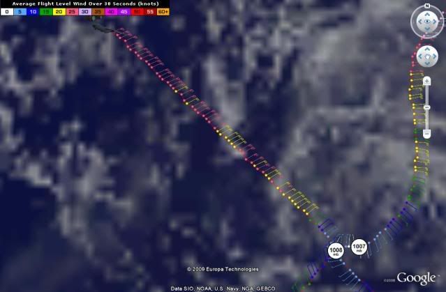
397
URNT12 KNHC 271827
VORTEX DATA MESSAGE AL052009
A. 27/17:52:50Z
B. 27 deg 15 min N
073 deg 22 min W
C. NA
D. 21 kt
E. 133 deg 37 nm
F. 213 deg 20 kt
G. 133 deg 44 nm
H. EXTRAP 1008 mb
I. 24 C / 395 m
J. 24 C / 396 m
K. 20 C / NA
L. NA
M. NA
N. 134 / 01
O. 0.02 / 1.5 nm
P. AF307 0505A DANNY OB 10
MAX FL WIND 50 KT NE QUAD 15:51:00Z
MAX OUTBOUND FL WIND 31 KT NW QUAD 18:25:50Z
SLP EXTRAP FROM BELOW 1500 FT
MAX FL TEMP 25 C 135 / 19 NM FROM FL CNTR
;
ATL: TROPICAL DEPRESSION DANNY (05L)
Moderator: S2k Moderators


Re: ATL: TROPICAL STORM DANNY
artist wrote:poof121 wrote:Interesting... NHC moved the points on the floater...
they do with each advisory, as their track changes. The points are not static. That is my understanding.
Please correct me if I am wrong guys!
They only change them every six hours. Next track change should be at 4 CDT.
But something interesting... Current vortex data message from recon has the center at 27 deg 15 min N 073 deg 22 min W or 27.25 N 73.36 W. Last advisory was 27.5 N 73.1 W. That's a 3 hour motion of southwest. Something is up...
0 likes

000
URNT15 KNHC 271833
AF307 0505A DANNY HDOB 34 20090827
182400 2826N 07442W 9655 00409 0116 +235 +196 064027 027 022 006 03
182430 2827N 07443W 9664 00401 0116 +236 +195 064026 026 016 004 03
182500 2828N 07444W 9663 00403 0117 +237 +195 067028 028 020 005 03
182530 2830N 07446W 9660 00405 0118 +226 +194 074029 030 031 008 03
182600 2831N 07447W 9667 00401 0119 +230 +192 067031 033 026 006 03
182630 2832N 07449W 9584 00464 0110 +231 +188 061029 030 024 003 03
182700 2833N 07450W 9297 00747 0123 +209 +185 064029 030 018 004 03
182730 2834N 07452W 8907 01146 0144 +189 +181 073029 030 026 000 03
182800 2836N 07453W 8506 01534 0144 +172 +172 075025 026 026 000 03
182830 2837N 07454W 8129 01924 0143 +155 +155 071025 026 029 001 00
182900 2839N 07455W 7761 02322 9990 +122 +999 073027 030 034 010 01
182930 2841N 07457W 7389 02708 9990 +092 +999 069031 033 034 012 01
183000 2842N 07458W 7157 02981 9990 +097 +999 066027 028 028 000 01
183030 2844N 07459W 7036 03126 9990 +099 +999 066033 036 026 002 01
183100 2846N 07500W 6966 03207 9990 +086 +999 068029 032 026 003 01
183130 2847N 07501W 6967 03209 0126 +078 +078 066028 029 023 004 01
183200 2849N 07503W 6965 03208 0111 +091 +091 061027 028 022 003 00
183230 2851N 07504W 6959 03217 0140 +070 +070 064032 033 032 013 00
183300 2852N 07505W 6977 03196 0135 +075 +075 061030 031 033 009 00
183330 2854N 07506W 6966 03211 0123 +087 +071 058027 028 024 004 00
$$
At 18:24:00Z (first observation), the observation was 284 miles (457 km) to the NE (35°) from Nassau, Bahamas.
At 18:33:30Z (last observation), the observation was 299 miles (481 km) to the NNE (27°) from Nassau, Bahamas.
0 likes
-
meandthestorm
- Tropical Wave

- Posts: 3
- Joined: Thu Aug 20, 2009 11:33 pm
Re: ATL: TROPICAL STORM DANNY
So you guys saying the storm is not moving? Wouldnt that give it a chance to build? I dont mean to ask many questions but like I said my weather man is dumb-founded right now saying UHH!!!! UHH what dude... 
0 likes
000
UZNT13 KWBC 271842
XXAA 77182 99294 70772 08097 99014 28456 ///// 00122 27456 04524
92808 21432 05527 85536 16424 06529 70174 10864 06019 50589 05758
11004 40761 16161 14504 30971 31165 21508 25098 42560 29015 20244
553// 29028 88999 77999
31313 09608 81822
61616 NOAA9 0605A DANNY OB 03
62626 SPL 2938N07721W 1836 LST WND 017 MBL WND 04524 AEV 20801 DL
M WND 02505 012176 WL150 04524 089 REL 2940N07719W 182234 SPG 293
8N07721W 183629 =
XXBB 77188 99294 70772 08097 00014 28456 11948 22818 22932 22042
33850 16424 44807 14215 55789 14657 66739 12456 77697 10864 88645
06266 99626 04462 11606 02847 22599 02450 33594 02260 44588 01658
55575 01064 66554 00763 77541 01758 88531 02563 99495 06358 11468
09159 22458 10165 33445 11559 44415 14164 55409 14766 66390 17158
77327 25968 88266 38558 99235 45962 11223 49162 22200 553// 33176
58957
21212 00014 ///// 11012 04524 22947 04525 33885 06032 44850 06529
55806 06034 66748 07520 77688 05017 88647 06519 99523 02001 11321
20005 22278 23514 33249 29015 44235 28020 55208 30030 66184 27528
77176 28532
31313 09608 81822
61616 NOAA9 0605A DANNY OB 03
62626 SPL 2938N07721W 1836 LST WND 017 MBL WND 04524 AEV 20801 DL
M WND 02505 012176 WL150 04524 089 REL 2940N07719W 182234 SPG 293
8N07721W 183629 =
0 likes
Re: ATL: TROPICAL STORM DANNY
meandthestorm wrote:So you guys saying the storm is not moving? Wouldnt that give it a chance to build? I dont mean to ask many questions but like I said my weather man is dumb-founded right now saying HUH!!!! HUH what dude...
Like don't worry about it, just read what our pro's say.
0 likes
-
wxman57

- Moderator-Pro Met

- Posts: 23172
- Age: 68
- Joined: Sat Jun 21, 2003 8:06 pm
- Location: Houston, TX (southwest)
Re: ATL: TROPICAL STORM DANNY
Ignore that little swirl that WAS the center, it's weakening as it moves off to the west. Focus your attention on the convection to the east. That's Danny. The convection isn't moving much now. Wind shear is just too strong. But the convection will generate inflow into this region eventually, if it persists. Look for a new center to develop closer to (or under) the convection tonight, assuming the wind shear drops. And that upper trof approaches from the west tomorrow, driving the whole sheared mess northward as per most model guidance.
0 likes
Atlantic USAF High-Density Observations
--------------------------------------------------------------------------------
000
URNT15 KNHC 271843
AF307 0505A DANNY HDOB 35 20090827
183400 2856N 07507W 6966 03211 0117 +094 +067 063023 023 028 006 00
183430 2858N 07509W 6966 03217 0119 +094 +066 069022 023 028 003 03
183500 2859N 07509W 6961 03221 0112 +098 +067 074019 020 027 000 03
183530 2901N 07508W 6978 03201 0114 +096 +070 079020 022 027 002 03
183600 2902N 07507W 6965 03210 0116 +090 +072 076022 024 027 002 03
183630 2903N 07505W 6967 03207 0118 +089 +072 066021 021 026 002 00
183700 2903N 07503W 6966 03211 0112 +094 +070 072021 022 032 000 00
183730 2904N 07502W 6967 03210 0112 +095 +068 073021 021 031 000 03
183800 2905N 07500W 6967 03211 0112 +095 +067 074023 025 030 001 00
183830 2906N 07459W 6967 03208 0112 +095 +068 069021 022 029 000 00
183900 2907N 07457W 6966 03210 0111 +095 +068 067019 020 031 000 00
183930 2908N 07456W 6967 03207 0112 +095 +068 065019 019 031 000 00
184000 2909N 07454W 6967 03208 0112 +095 +068 067019 020 030 000 00
184030 2910N 07453W 6966 03207 0110 +095 +069 071019 020 028 002 00
184100 2911N 07452W 6967 03212 0113 +095 +069 071018 018 030 002 03
184130 2913N 07451W 6966 03212 0114 +095 +069 069019 019 999 999 03
184200 2914N 07453W 6966 03212 0110 +097 +069 061019 019 999 999 03
184230 2913N 07455W 6967 03207 0112 +096 +070 055021 021 030 003 03
184300 2912N 07456W 6967 03205 0111 +095 +071 050020 021 030 000 00
184330 2910N 07458W 6969 03207 0105 +100 +071 046019 019 029 001 00
$$
;
At 18:34:00Z (first observation), the observation was 300 miles (484 km) to the NNE (27°) from Nassau, Bahamas.
At 18:43:30Z (last observation), the observation was 319 miles (513 km) to the NNE (27°) from Nassau, Bahamas.
0 likes
-
Aric Dunn
- Category 5

- Posts: 21238
- Age: 43
- Joined: Sun Sep 19, 2004 9:58 pm
- Location: Ready for the Chase.
- Contact:
too many assumptions.. fact of the matter the center is still dominate and not weakening as of yet.. and mid level wind shear is still the main cause the upper levels are better.. the low level steering is still towards the west .. everything depends on a deep layered trof that does not exist yet..
0 likes
-
PTrackerLA

- Category 5
- Posts: 5281
- Age: 42
- Joined: Thu Oct 10, 2002 8:40 pm
- Location: Lafayette, LA
Re: ATL: TROPICAL STORM DANNY
Danny is such a mess, can't it all just scoot off to the NE already?  I feel sorry for forecasters with storms like these, glad it isn't my job!
0 likes
-
Aquawind

- Category 5
- Posts: 6714
- Age: 62
- Joined: Mon Jun 16, 2003 10:41 pm
- Location: Salisbury, NC
- Contact:
Re: ATL: TROPICAL STORM DANNY
..I don't think so.. look at the convective tops and the motion suggesting another MLC at least and prolly a reform..happens all the time in a sheared enviro..fact of the matter the center is still dominate and not weakening as of yet..
0 likes
Re: ATL: TROPICAL STORM DANNY
wxam57,
you may be right, but I think the LLC will survive and generate new convection when the upper level winds relax.
Lets see where this is in 24hrs.
Anyway my attention is going much further east, Invest 94 could be the big one this year!! It has the LOOK to it.
you may be right, but I think the LLC will survive and generate new convection when the upper level winds relax.
Lets see where this is in 24hrs.
Anyway my attention is going much further east, Invest 94 could be the big one this year!! It has the LOOK to it.
0 likes
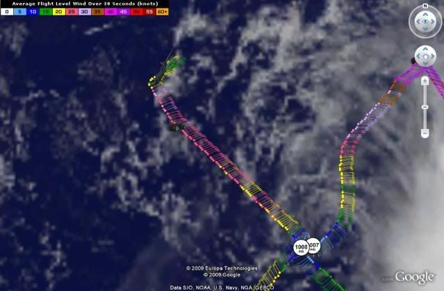
000
URNT15 KNHC 271853
AF307 0505A DANNY HDOB 36 20090827
184400 2909N 07459W 6967 03208 0104 +100 +071 048019 019 032 000 00
184430 2908N 07501W 6967 03209 0109 +095 +072 053020 021 030 001 00
184500 2906N 07502W 6967 03208 0107 +097 +072 059024 024 029 000 00
184530 2905N 07504W 6967 03212 0114 +095 +073 066026 026 999 999 03
184600 2905N 07506W 6859 03344 0113 +090 +072 066025 025 025 000 03
184630 2907N 07508W 6607 03657 0108 +077 +071 066023 024 999 999 03
184700 2908N 07509W 6290 04067 0101 +056 +056 071016 018 999 999 03
184730 2910N 07510W 6063 04366 9990 +038 +999 066014 016 999 999 05
184800 2911N 07511W 5818 04673 9990 +022 +999 051012 013 999 999 05
184830 2913N 07512W 5641 04934 9990 +009 +999 068012 014 023 002 05
184900 2914N 07513W 5407 05278 0287 -009 +999 062009 011 999 999 05
184930 2916N 07514W 5219 05557 0305 -027 +999 043008 008 999 999 05
185000 2917N 07515W 5080 05776 0318 -038 +999 063007 008 020 002 05
185030 2919N 07517W 4944 05991 0334 -048 +999 080006 007 020 002 05
185100 2920N 07518W 4804 06215 0350 -064 +999 073009 010 023 000 05
185130 2922N 07519W 4666 06444 0364 -079 +999 061010 010 026 000 05
185200 2923N 07520W 4534 06658 0371 -092 +999 054011 013 024 001 05
185230 2925N 07522W 4416 06862 0383 -102 +999 042015 016 026 000 05
185300 2926N 07523W 4288 07087 0398 -120 +999 023016 016 024 003 01
185330 2928N 07524W 4178 07282 0410 -135 +999 009015 016 015 003 05
$$
;
At 18:44:00Z (first observation), the observation was 318 miles (511 km) to the NNE (27°) from Nassau, Bahamas.
At 18:53:30Z (last observation), the observation was 327 miles (526 km) to the NNE (21°) from Nassau, Bahamas.
0 likes
-
AtlanticWind

- S2K Supporter

- Posts: 1898
- Age: 67
- Joined: Sun Aug 08, 2004 9:57 pm
- Location: Plantation,Fla
Re: ATL: TROPICAL STORM DANNY
wxman57 wrote:Ignore that little swirl that WAS the center, it's weakening as it moves off to the west. Focus your attention on the convection to the east. That's Danny. The convection isn't moving much now. Wind shear is just too strong. But the convection will generate inflow into this region eventually, if it persists. Look for a new center to develop closer to (or under) the convection tonight, assuming the wind shear drops. And that upper trof approaches from the west tomorrow, driving the whole sheared mess northward as per most model guidance.
I think that little swirl IS Danny and if that winds down then write off this system.(which may be the most likely outcome)
0 likes
Could someone else post for awhile, please?
http://www.nhc.noaa.gov/text/URNT15-USAF.shtml?
refresh every 5 minutes or so for latest high density obs
http://www.nhc.noaa.gov/text/URNT15-USAF.shtml?
refresh every 5 minutes or so for latest high density obs
0 likes
Who is online
Users browsing this forum: No registered users and 11 guests