
Strong tropical wave ssw of Cape Verde islands
Moderator: S2k Moderators
Forum rules

The posts in this forum are NOT official forecasts and should not be used as such. They are just the opinion of the poster and may or may not be backed by sound meteorological data. They are NOT endorsed by any professional institution or STORM2K. For official information, please refer to products from the National Hurricane Center and National Weather Service.
-
cycloneye

- Admin

- Posts: 148741
- Age: 69
- Joined: Thu Oct 10, 2002 10:54 am
- Location: San Juan, Puerto Rico
Re: Strong tropical wave south of Cape Verde islands
Recent images.Code orange or red at 8 PM?


0 likes
-
Emmett_Brown

- Category 5

- Posts: 1433
- Joined: Wed Aug 24, 2005 9:10 pm
- Location: Sarasota FL
Re: Strong tropical wave south of Cape Verde islands
Long trackers happen:

Then again, that was an exception.
Then again, that was an exception.
0 likes

Re: Re:
Bocadude85 wrote:quote="fci"]If this develops near the CV Islands, then I think it will recurve very early.
Say what you want about not looking at past storms but I looked at the past 10 years and ALL storms that were named EAST of 30 curved out to sea and were fish.
Pretty compelling, if you ask me.
If current synopsis were your only guide you would be wrong much of the time given the length of time we are talking about a storm that develops by the CV Islands and the fact that we are wrong a lot of the time in predicting systems.
So, I rely heavily on history and it guides me quite well, particularly when we are surmising what a system will do many days out. Sure, current synopsis is the way to go for short to mid-term prognosticating but I will take history in longer term "guessing" and certainly the evidence is compelling for storms that develop by the CV Islands to recurve and recurve early.
Look it up. You will likely have to go WAY back to find a storm that developed east of 30 (by the CV Islands) that made it across.
Here are a few storms that formed nears the CV islands and made it across
Actually since this system is so close to the CV islands, and people are talking quick development; I used 30 degrees as my cutoff in looking at storms that developed close the the CV islands.
Ike was named at 40.6
1947 storm DID get named at 20.1
1928 Lake O got named at 20.4
You are correct on 2 of them, but we have to go back 62 years and 81 years to find examples!
Most recently, Debby in 2006, Danielle in 2004 and Alberto in 2000 formed east of 30 but recurved out.
No arguement here about what strong ridges can do. I remember Betsy as well as Andrew and Jeanne but they were not long trackers from east of 30.
Thanks for the research, I find the subject fascinating (even if Luis doesn't!) and I think it relevant in the discussion of this system.
fci
0 likes


Re: Re:
Ivanhater wrote:fci wrote:If this develops near the CV Islands, then I think it will recurve very early.
Rarely do we see a system that develops real early make it across.
Sometimes, if it develops near the islands it curves right past the islands.
I can't recall the names in the past that did this, but I think that it has happened more often than not
It is better to look at the current synopsis than to look at past storms..the models are showing ridging developing across the entire Atlantic at the time this is moving west..I'm not seeing anything to show this being a recurver, at least according to the models now.
Seems the models are showing the strongest ridging without any weakness of the season.
Ivanhater i think you have the right take on this system.There are a few on this forum that seem to believe that everthing that forms in the atlantic will recurve this season. I think they will get a few surprises in September.
0 likes
-
Evil Jeremy

- S2K Supporter

- Posts: 5463
- Age: 32
- Joined: Mon Apr 10, 2006 2:10 pm
- Location: Los Angeles, CA

Yeah but this season we have seen constant weaknesses and the highs haven't exactly been that strong even when we've seen less in the way of the constant troughing.
Thats why some of us are saying it will recurve.
However what I will say is the upper high does build to some extent so whilst recurving has to be favored, there is always a chance this makes it across. The thing to note is whilst the high is present in the Atlantic the models still do show troughing come down fairly often and though it does start running out of puff by about 192hrs this system may be too far north by that time to really be a major threat to the USA...however it'd also be very foolish of me to think recurvature is the only answer this season, but it has to be the fave.
Also looks like code orange and quite possibly 94L sooner then later.
0 likes
-
cycloneye
- Admin
- Posts: 148741
- Age: 69
- Joined: Thu Oct 10, 2002 10:54 am
- Location: San Juan, Puerto Rico
Re: Strong tropical wave south of Cape Verde islands
No change in the code yellow status.
ABNT20 KNHC 262333
TWOAT
TROPICAL WEATHER OUTLOOK
NWS TPC/NATIONAL HURRICANE CENTER MIAMI FL
800 PM EDT WED AUG 26 2009
FOR THE NORTH ATLANTIC...CARIBBEAN SEA AND THE GULF OF MEXICO...
THE NATIONAL HURRICANE CENTER IS ISSUING ADVISORIES ON TROPICAL
STORM DANNY...LOCATED ABOUT 390 MILES EAST OF NASSAU IN THE
BAHAMAS.
A TROPICAL WAVE LOCATED OVER THE FAR EASTERN ATLANTIC CONTINUES TO
PRODUCE AN AREA OF DISORGANIZED SHOWERS AND THUNDERSTORMS SOUTH OF
THE CAPE VERDE ISLANDS. DEVELOPMENT OF THIS SYSTEM WILL LIKELY BE
SLOW TO OCCUR AS IT MOVES WESTWARD AT 10 TO 15 MPH OVER THE NEXT
COUPLE OF DAYS. THERE IS A LOW CHANCE...LESS THAN 30 PERCENT...OF
THIS SYSTEM BECOMING A TROPICAL CYCLONE DURING THE NEXT 48 HOURS.
ELSEWHERE...TROPICAL CYCLONE FORMATION IS NOT EXPECTED DURING THE
NEXT 48 HOURS.
$$
FORECASTER BERG
0 likes
-
HurricaneBelle

- S2K Supporter
- Posts: 1203
- Joined: Sun Aug 27, 2006 6:12 pm
- Location: Clearwater, FL
Re: Re:
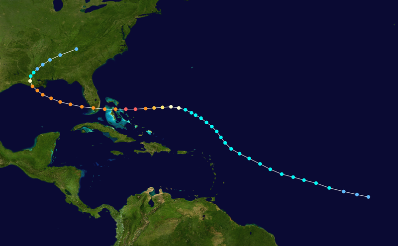
Bocadude85 wrote:Here are a few storms that formed nears the CV islands and made it across
http://upload.wikimedia.org/wikipedia/commons/thumb/2/27/1947_Fort_Lauderdale_hurricane_track.png/800px-1947_Fort_Lauderdale_hurricane_track.png
http://upload.wikimedia.org/wikipedia/commons/thumb/5/5f/Ike_2008_track.png/800px-Ike_2008_track.png
http://upload.wikimedia.org/wikipedia/commons/thumb/5/5d/1928_Okeechobee_hurricane_track.png/800px-1928_Okeechobee_hurricane_track.png
And these other storms below show what a strong ridge is capable of
http://upload.wikimedia.org/wikipedia/commons/thumb/a/af/Andrew_1992_track.png/800px-Andrew_1992_track.png
http://upload.wikimedia.org/wikipedia/commons/thumb/5/56/Jeanne_2004_track.png/800px-Jeanne_2004_track.png
Not to mention Donna 1960, which practically came off the African coast as a TS (it brought down a plane in Dakar, Senegal) and cut through the Keys, SW FL and rode the entire east coast.
0 likes
Yeah the thing to watch is IF we get a reduction in the strength of the upper troughs in the US, they have been quite potent, being able to send fronts right into the Gulf, so they clearly have the strength to also pick up something in the Atlantic, even a fairly weak one is going to lift up the system enough so the next trough or maybe even the one after that would finish the job.
Still should be an interesting one to watch, I think this is quite a likely developer...mind you could have an Ana situation given the lack of development on most of the models. I can only assume shear is going to be progged to be higher aloft downwind on those models...or simply they haven't got a good grip on the set-up.
Still should be an interesting one to watch, I think this is quite a likely developer...mind you could have an Ana situation given the lack of development on most of the models. I can only assume shear is going to be progged to be higher aloft downwind on those models...or simply they haven't got a good grip on the set-up.
0 likes

Re:
KWT wrote:Yeah but this season we have seen constant weaknesses and the highs haven't exactly been that strong even when we've seen less in the way of the constant troughing.
Thats why some of us are saying it will recurve.
However what I will say is the upper high does build to some extent so whilst recurving has to be favored, there is always a chance this makes it across. The thing to note is whilst the high is present in the Atlantic the models still do show troughing come down fairly often and though it does start running out of puff by about 192hrs this system may be too far north by that time to really be a major threat to the USA...however it'd also be very foolish of me to think recurvature is the only answer this season, but it has to be the fave.
Also looks like code orange and quite possibly 94L sooner then later.
KWT, we may be at the beginning of a major pattern change with ridging building in the western atlantic and east coast. I say may because its based on the 8-10 day ECMWF operational model 500 mb forecast. The Euro has a rather deep trough progress into the NW US which we haven't seen much so far this summer with high pressure out west and troughing over the eastern US. As this trough progresses out west it'll build heights in the eastern US - sometime during the labor day holiday weekend. Just something to watch.
0 likes
-
littlevince

- S2K Supporter
- Posts: 768
- Joined: Fri Oct 21, 2005 10:45 am
- Location: Portugal

-
Blown Away

- S2K Supporter
- Posts: 10253
- Joined: Wed May 26, 2004 6:17 am
Re: Strong tropical wave south of Cape Verde islands
It looks like the convection is starting to consolidate at a lower latitude, say around 12N.
http://www.ssd.noaa.gov/eumet/eatl/loop-avn.html
http://www.ssd.noaa.gov/eumet/eatl/loop-avn.html
0 likes
Re: Re:
ronjon wrote:
KWT, we may be at the beginning of a major pattern change with ridging building in the western atlantic and east coast. I say may because its based on the 8-10 day ECMWF operational model 500 mb forecast. The Euro has a rather deep trough progress into the NW US which we haven't seen much so far this summer with high pressure out west and troughing over the eastern US. As this trough progresses out west it'll build heights in the eastern US - sometime during the labor day holiday weekend. Just something to watch.
I totally agree however that pattern change may not quite come in quickly enough to prevent this being at a northerly enough latitude that even weak weaknesses will do the job, but we shall see.
Its the wave after this one that is at bigger risk if this pattern change does occur, as has been hinted at for a little while now.
0 likes
-
cycloneye
- Admin
- Posts: 148741
- Age: 69
- Joined: Thu Oct 10, 2002 10:54 am
- Location: San Juan, Puerto Rico
Re: Strong tropical wave south of Cape Verde islands
8 PM Discussion.
TROPICAL WAVES...
A NEW TROPICAL WAVE IS INTRODUCED OFF THE COAST OF AFRICA ALONG
13W/14W S OF 19N MOVING W 10-15 KT. POSITION IS BASED ON SURFACE
AND SHIP OBSERVATIONS AND A RECENT QUIKSCAT PASS. A MAXIMUM IN
SSMI PRECIPITABLE WATER IS ALSO NOTED. SCATTERED MODERATE TO
ISOLATED STRONG CONVECTION IS WELL W OF THE AXIS FROM 9N-13N
BETWEEN 23W-27W.
That shows there is some easterly shear and that is why NHC says development slow to occur.
0 likes
-
Blown Away
- S2K Supporter
- Posts: 10253
- Joined: Wed May 26, 2004 6:17 am
Re: Strong tropical wave south of Cape Verde islands
Yeah, I don't think this system will be in a big hurry to develope and should continue W for many days. The question is have we reached the time of the year when the BH is going to start building stronger and will this wave get trapped underneath??
0 likes
-
Wx_Warrior
- Category 5
- Posts: 2718
- Joined: Thu Aug 03, 2006 3:58 pm
- Location: Beaumont, TX
Re: Strong tropical wave south of Cape Verde islands
Who knows...wait and see. We can procrastinate until the cows come home....MOOOOOOO
0 likes
-
Ivanhater

- Storm2k Moderator

- Posts: 11170
- Age: 39
- Joined: Fri Jul 01, 2005 8:25 am
- Location: Pensacola
Re: Re:
KWT wrote:ronjon wrote:
KWT, we may be at the beginning of a major pattern change with ridging building in the western atlantic and east coast. I say may because its based on the 8-10 day ECMWF operational model 500 mb forecast. The Euro has a rather deep trough progress into the NW US which we haven't seen much so far this summer with high pressure out west and troughing over the eastern US. As this trough progresses out west it'll build heights in the eastern US - sometime during the labor day holiday weekend. Just something to watch.
I totally agree however that pattern change may not quite come in quickly enough to prevent this being at a northerly enough latitude that even weak weaknesses will do the job, but we shall see.
Its the wave after this one that is at bigger risk if this pattern change does occur, as has been hinted at for a little while now.
Back from class. Great discussion here. The big thing I'm pointing out is the argument "oh it's way out there, it will recurve." Like ronjon pointed out, the models are sniffing out a pattern change for the start of September with troughs in the western U.S and a ridge in the Southeastern U.S extended into the tropical Atlantic.
The argument that this may be to far north depends on what model you look at. Looking at the UKMET, it shows this at a fairly low latitude with a strong ridge sitting on top of it, even loses some latitude at the end of the run. Seems to me, the models show a pattern change in the mid to long term, so this needs to be watched.
0 likes
-
HurricaneMaster_PR

- Category 2

- Posts: 795
- Joined: Tue Jul 22, 2003 6:23 pm
- Location: San Juan, Puerto Rico
Re: Strong tropical wave south of Cape Verde islands
Blown_away wrote:It looks like the convection is starting to consolidate at a lower latitude, say around 12N.
http://www.ssd.noaa.gov/eumet/eatl/loop-avn.html
I agree, thuderstorm activity is consolidating close to the 10N latitude..

0 likes
-
lonelymike
- S2K Supporter
- Posts: 634
- Joined: Sat Jul 26, 2008 10:12 am
- Location: walton county fla
Re: Re:
Ivanhater wrote:KWT wrote:ronjon wrote:
KWT, we may be at the beginning of a major pattern change with ridging building in the western atlantic and east coast. I say may because its based on the 8-10 day ECMWF operational model 500 mb forecast. The Euro has a rather deep trough progress into the NW US which we haven't seen much so far this summer with high pressure out west and troughing over the eastern US. As this trough progresses out west it'll build heights in the eastern US - sometime during the labor day holiday weekend. Just something to watch.
I totally agree however that pattern change may not quite come in quickly enough to prevent this being at a northerly enough latitude that even weak weaknesses will do the job, but we shall see.
Its the wave after this one that is at bigger risk if this pattern change does occur, as has been hinted at for a little while now.
Back from class. Great discussion here. The big thing I'm pointing out is the argument "oh it's way out there, it will recurve." Like ronjon pointed out, the models are sniffing out a pattern change for the start of September with troughs in the western U.S and a ridge in the Southeastern U.S extended into the tropical Atlantic.
The argument that this may be to far north depends on what model you look at. Looking at the UKMET, it shows this at a fairly low latitude with a strong ridge sitting on top of it, even loses some latitude at the end of the run. Seems to me, the models show a pattern change in the mid to long term, so this needs to be watched.
If you're relying on the UKMET go find another model. It's been horrible this year.
0 likes