ATL: TROPICAL DEPRESSION DANNY (05L)

Moderator: S2k Moderators

Message
Author
User avatar
ConvergenceZone
Category 5
Category 5
Posts: 5194
Joined: Fri Jul 29, 2005 1:40 am
Location: Northern California

Re: Re:

#1281 Postby ConvergenceZone » Wed Aug 26, 2009 3:05 pm

Air Force Met wrote:
ConvergenceZone wrote:Danny boy is looking like a mess. I don't see how this is going to make hurricane strength, let alone strong tropical storm strength. Heck, I don't even know if it's going to survive at this point....So where it's going to go may not even be an issue afterall.


Nothing like now casting... :lol:

Just a reminder: There are so many times in the past where a storm looked bad...exposed...naked (a lot worse than Danny)...only to get its act together quickly. I can't even count how many times that has happened. Danny is going to survive....and all you have to do is look at a little history to see how this can easily become a hurricane. All the center needs to do is tuck/reform under the convection...and I think it is doing that now (allbeit slowly).


Might need to bookmark this post for later... :P


don't make me eat crow. I've had to eat servings of that before... :wink:
0 likes   

Derek Ortt

#1282 Postby Derek Ortt » Wed Aug 26, 2009 3:07 pm

if there center reforms to the NE, I really really like my out to sea track with only minimal impacts until we reach Newfoundland
0 likes   

OuterBanker
S2K Supporter
S2K Supporter
Posts: 1731
Joined: Wed Feb 26, 2003 10:53 am
Location: Nags Head, NC
Contact:

#1283 Postby OuterBanker » Wed Aug 26, 2009 3:08 pm

Just a little fun. Accuweather forecast for Nags Head Friday.

Tropical storm Danny bringing strong winds and heavy winds. Watch for rough surf. Winds sustained 46 gusts to 75.

Can't decide whether to surf or hang glide Friday.
0 likes   

HurricaneRobert
Category 3
Category 3
Posts: 812
Joined: Fri May 18, 2007 9:31 pm

Re:

#1284 Postby HurricaneRobert » Wed Aug 26, 2009 3:08 pm

KWT wrote:Yeah it seems much more likely that this LLC will eventually weaken and a new one forms in the convection however that would probably limit how strong this system could become given the time scales involved.


I wouldn't try to predict intensity yet. RI is possible.
0 likes   

Sanibel
Category 5
Category 5
Posts: 10375
Joined: Mon Aug 30, 2004 11:06 pm
Location: Offshore SW Florida

Re: ATL: TROPICAL STORM DANNY

#1285 Postby Sanibel » Wed Aug 26, 2009 3:09 pm

Danny's western outer edge is pushing the daytime convection across Florida and towards us.


And yes the center could be elongated and the center we see could be its SW corner.
Last edited by Sanibel on Wed Aug 26, 2009 3:13 pm, edited 1 time in total.
0 likes   

User avatar
artist
Category 5
Category 5
Posts: 9792
Joined: Mon Jun 06, 2005 3:26 pm
Location: West Palm

#1286 Postby artist » Wed Aug 26, 2009 3:10 pm

Atlantic USAF High-Density Observations
--------------------------------------------------------------------------------


000
URNT15 KNHC 262007
AF307 0205A DANNY HDOB 30 20090826
195800 2516N 07112W 9586 00431 0069 +228 +222 026005 005 006 000 00
195830 2515N 07111W 9583 00434 0069 +230 +221 040006 007 999 999 03
195900 2514N 07109W 9588 00429 0082 +230 +222 048006 007 005 000 03
195930 2513N 07108W 9596 00451 0101 +230 +224 068004 004 999 999 03
200000 2512N 07106W 9588 00429 0082 +227 +226 065004 006 999 999 03
200030 2511N 07105W 9592 00457 0093 +227 +227 026003 004 999 999 03
200100 2510N 07104W 9584 00432 0077 +219 +219 032002 005 999 999 03
200130 2509N 07102W 9593 00454 0097 +218 +218 245003 005 999 999 03
200200 2508N 07101W 9591 00428 0090 +230 +221 244007 008 999 999 03
200230 2507N 07100W 9585 00432 0072 +231 +216 234009 010 999 999 03
200300 2506N 07059W 9592 00457 0089 +230 +218 229010 011 001 002 03
200330 2505N 07058W 9580 00438 0070 +230 +213 239014 015 005 000 00
200400 2503N 07056W 9589 00430 0071 +230 +215 242015 015 007 000 00
200430 2502N 07055W 9589 00431 0071 +229 +219 244015 016 012 000 00
200500 2501N 07053W 9586 00434 0072 +225 +225 245016 017 009 000 03
200530 2459N 07052W 9581 00437 0078 +225 +225 246016 017 011 000 03
200600 2458N 07051W 9578 00443 0073 +230 +211 241017 017 015 000 03
200630 2457N 07049W 9586 00437 0074 +230 +209 235017 017 017 000 03
200700 2455N 07047W 9585 00437 0075 +228 +213 235017 018 016 000 00
200730 2454N 07046W 9582 00440 0075 +228 +213 239018 019 014 000 03
$$
0 likes   

User avatar
carolina_73
Tropical Storm
Tropical Storm
Posts: 148
Joined: Wed Jul 23, 2008 1:30 am

Re: ATL: TROPICAL STORM DANNY

#1287 Postby carolina_73 » Wed Aug 26, 2009 3:12 pm

If the track even slightly shifts west looks as if New England could take a direct hit. It's a good thing Danny is weak and still in slow formation mode. Water temps are VERY HIGH off the EC this season. Danny will have water temps 85+ to work with in the gulfstream. It's even close to 80 off the coast of NE for crying out loud. Danny should have a nice window Thursday and Friday to ramp up. Once it hits those waters i have a feeling the W side of Danny will start to ramp up. I do worry with the right situation in place the EC could get a real nasty intensifying cane later this season. Waters off the EC haven't been disturbed in a very long time and it's not even near the peak.
0 likes   

User avatar
artist
Category 5
Category 5
Posts: 9792
Joined: Mon Jun 06, 2005 3:26 pm
Location: West Palm

#1288 Postby artist » Wed Aug 26, 2009 3:13 pm

At 19:58:00Z (first observation), the observation was 385 miles (619 km) to the E (88°) from Nassau, Bahamas.
At 20:07:30Z (last observation), the observation was 412 miles (663 km) to the E (92°) from Nassau, Bahamas.
0 likes   

Derek Ortt

#1289 Postby Derek Ortt » Wed Aug 26, 2009 3:14 pm

why does everyone focus on SST

Atmospheric conditions will be far more important than SSTs will be. It has warm SSTs now yet its not intensifying
0 likes   

User avatar
artist
Category 5
Category 5
Posts: 9792
Joined: Mon Jun 06, 2005 3:26 pm
Location: West Palm

Re:

#1290 Postby artist » Wed Aug 26, 2009 3:15 pm

Derek Ortt wrote:why does everyone focus on SST

Atmospheric conditions will be far more important than SSTs will be. It has warm SSTs now yet its not intensifying

maybe explaining it would help us to understand Derek. :wink:
0 likes   

User avatar
storms NC
Tropical Storm
Tropical Storm
Posts: 247
Age: 69
Joined: Tue Sep 14, 2004 2:41 pm
Location: Coast of NC & southwest coast of Fla

Re:

#1291 Postby storms NC » Wed Aug 26, 2009 3:16 pm

OuterBanker wrote:One other note. The entire east coast has seen above average rainfall this summer. Trees are full with saturated roots which make for easy takedown. Even a minimum hurricane could spell trouble for the northeast.


We have lost all of our Big oaks and dogwoods from bonnie fran floyd. I have 1 more that I would like to have come down and save me a few $$$$ to have it done. LOL No really we have lost all but 1 tree and we had a lot. 11 oak trees over 100 years old and 7 dogwoods. I have a Black walnut that I want to have cut down. It is very old and is very ugly. It wouldn't hurt any thing if a storm took it down.. My kids they are grown but they come here when there is a storm. Sit on the back deck and count the trees they hear crack or fall. Now my kids are 32 29 27 and 21. All but the baby is married with kids. I guess we never grow up.LOL
0 likes   

User avatar
RNGR
Military Member
Military Member
Posts: 153
Joined: Sun Jul 19, 2009 1:13 pm
Location: Ft. Benning Ga

Re: Re:

#1292 Postby RNGR » Wed Aug 26, 2009 3:17 pm

artist wrote:
Derek Ortt wrote:why does everyone focus on SST

Atmospheric conditions will be far more important than SSTs will be. It has warm SSTs now yet its not intensifying

maybe explaining it would help us to understand Derek. :wink:


It's pretty obvious that even if the water was 100 degrees, it wouldnt be enough to fight off 40 or so kts of shear AND a bunch of dry air..
0 likes   

User avatar
Lowpressure
S2K Supporter
S2K Supporter
Posts: 2032
Age: 58
Joined: Sun Sep 14, 2003 9:17 am
Location: Charlotte, North Carolina

Re:

#1293 Postby Lowpressure » Wed Aug 26, 2009 3:18 pm

Derek Ortt wrote:why does everyone focus on SST

Atmospheric conditions will be far more important than SSTs will be. It has warm SSTs now yet its not intensifying


I would say because when he SHOULD be organizing the best, he will be over or very near the Gulf Stream at or near 30 north- it matters then.
0 likes   

User avatar
Lowpressure
S2K Supporter
S2K Supporter
Posts: 2032
Age: 58
Joined: Sun Sep 14, 2003 9:17 am
Location: Charlotte, North Carolina

Re:

#1294 Postby Lowpressure » Wed Aug 26, 2009 3:20 pm

Derek Ortt wrote:why does everyone focus on SST

Atmospheric conditions will be far more important than SSTs will be. It has warm SSTs now yet its not intensifying


I would say because when he SHOULD be organizing the best, he will be over or very near the Gulf Stream at or near 30 north- it matters then.
0 likes   

User avatar
artist
Category 5
Category 5
Posts: 9792
Joined: Mon Jun 06, 2005 3:26 pm
Location: West Palm

Re: Re:

#1295 Postby artist » Wed Aug 26, 2009 3:20 pm

RNGR wrote:
artist wrote:
Derek Ortt wrote:why does everyone focus on SST

Atmospheric conditions will be far more important than SSTs will be. It has warm SSTs now yet its not intensifying

maybe explaining it would help us to understand Derek. :wink:


It's pretty obvious that even if the water was 100 degrees, it wouldnt be enough to fight off 40 or so kts of shear AND a bunch of dry air..

I guess my reasoning of explaining is those that are new to this can never learn if they are not told what those other conditions are. Sometimes I think all of us that have been around here for awhile forget what it can be like to be a newby at all this. Since I don't study the storms so much as see what others are saying I know it is nice to have these reminders of what can effect a storm out there.
0 likes   

User avatar
jdray
Category 3
Category 3
Posts: 853
Joined: Tue Aug 31, 2004 10:07 pm
Location: NE Florida

Re: ATL: TROPICAL STORM DANNY

#1296 Postby jdray » Wed Aug 26, 2009 3:23 pm

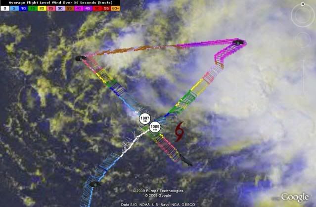
Sanibel wrote:Danny's western outer edge is pushing the daytime convection across Florida and towards us.


And yes the center could be elongated and the center we see could be its SW corner.


Yup, even with Danny passing well to our east, the low pressure and trough squeezing in from the Panhandle will cause some nice precip and nasty weather for a day or two.

000
FXUS62 KJAX 261843
AFDJAX

AREA FORECAST DISCUSSION
NATIONAL WEATHER SERVICE JACKSONVILLE FL
243 PM EDT WED AUG 26 2009

.SYNOPSIS...SEVERAL UPPER LEVEL FEATURES ARE CUT OFF S OF THE MID-
LATITUDE FLOW. TROF EXTENDS FROM OFF THE NEW ENGLAND COAST TO THE
E BAHAMAS JUST TO THE W OF TS DANNY. A NARROW RIDGE EXTENDS FROM
THE E CAROLINAS TO W CUBA. A CLOSED UPPER LOW IS PRESENTLY LOCATED
OVER THE LOWER MS VALLEY. AT THE SFC...A QUASI-STATIONARY FRONT
EXTENDS FROM A WAVE ALONG THE MID-ATLC COAST TO ANOTHER WAVE OVER
THE CENTRAL FL PANHANDLE. UPPER LOW UPSTREAM IS PRODUCING A LARGE
AREA OF CLOUDINESS AND PRECIP OVER THE NE GOMEX AND ACROSS MOST OF
OUR COUNTY WARNING AREA. MOST PRECIP IS NOW OCCURRING BETWEEN I-75
AND HIGHWAY 301 WITH A FEW STRONG TSTMS EMBEDDED. MOVEMENT OF THE
ACTIVITY IS A SLOW W DRIFT WHICH IS PRODUCING LOCALLY HEAVY
RAINFALL IN SOME AREAS.

.SHORT TERM...CLOSED UPPER LOW WILL CONTINUE PARKED OVER THE LOWER
MS VALLEY FOR THE NEXT 24 HOURS OR SO BEFORE OPENING UP INTO A
BROAD SE TROF THEREAFTER. AS A RESULT...FAVORABLE CONDITIONS FOR
PRECIP DEVELOPMENT WILL CONTINUE OVER THE AREA...FAVORING THE
DAYTIME HOURS WHEN MORE INSTABILITY WILL EXIST. POPS WILL
GRADUALLY BE ON THE DECLINE AFTER THU AS DRIER AIR ON W SIDE OF
DANNY IS SHUNTED S OVER THE AREA AND MORE OPEN UPPER TROF ALLOW
DEEPER ATMOSPHERIC MOISTURE TO SHIFT NE.

HAVE CONTINUED MENTION OF LOCALLY HEAVY RAINFALL DURING THE
DAYTIME ON THU...THEN GRADUALLY SCALE BACK QPF VALUES. WILL SEE
SOME LATE NIGHT FOG DEVELOPMENT EACH NIGHT...PARTICULARLY IN
RECENT RAIN AREAS. AS WAS THE CASE LAST NIGHT...VSBYS MAY DROP
BELOW A MILE IN SOME AREAS...BUT SUSPECT INCREASED CLOUD COVER MAY
MITIGATE THIS SOMEWHAT.


.LONG TERM...HAVE MADE FEW CHANGES TO THE EXTENDED PACKAGE. A COLD
FRONT IS PROGGED TO MOVE THE AREA EARLY NEXT WEEK WITH TEMPERATURES
3 TO 5 DEGREES BELOW NORMAL BY NEXT WED.
0 likes   

User avatar
HURAKAN
Professional-Met
Professional-Met
Posts: 46086
Age: 38
Joined: Thu May 20, 2004 4:34 pm
Location: Key West, FL
Contact:

#1297 Postby HURAKAN » Wed Aug 26, 2009 3:24 pm

Image
0 likes   

User avatar
RNGR
Military Member
Military Member
Posts: 153
Joined: Sun Jul 19, 2009 1:13 pm
Location: Ft. Benning Ga

Re: Re:

#1298 Postby RNGR » Wed Aug 26, 2009 3:25 pm

artist wrote:
RNGR wrote:
artist wrote:
It's pretty obvious that even if the water was 100 degrees, it wouldnt be enough to fight off 40 or so kts of shear AND a bunch of dry air..

I guess my reasoning of explaining is those that are new to this can never learn if they are not told what those other conditions are. Sometimes I think all of us that have been around here for awhile forget what it can be like to be a newby at all this. Since I don't study the storms so much as see what others are saying I know it is nice to have these reminders of what can effect a storm out there.


I see your point

To my understanding, air can rise as much as it wants to but if the atmosphere isnt conductive, the rising air will not be able to become organized.
0 likes   

User avatar
HURAKAN
Professional-Met
Professional-Met
Posts: 46086
Age: 38
Joined: Thu May 20, 2004 4:34 pm
Location: Key West, FL
Contact:

#1299 Postby HURAKAN » Wed Aug 26, 2009 3:25 pm

197
URNT12 KNHC 262015
VORTEX DATA MESSAGE AL052009
A. 26/20:01:20Z
B. 25 deg 10 min N
071 deg 03 min W
C. NA
D. 26 kt
E. 310 deg 66 nm
F. 065 deg 31 kt
G. 310 deg 86 nm
H. EXTRAP 1007 mb
I. 23 C / 457 m
J. 23 C / 459 m
K. 22 C / NA
L. NA
M. NA
N. 134 / 1
O. 0.02 / 3 nm
P. AF307 0205A DANNY OB 07
MAX FL WIND 50 KT NE QUAD 18:59:10Z
SLP EXTRAP FROM BELOW 1500 FT
;
0 likes   

User avatar
carolina_73
Tropical Storm
Tropical Storm
Posts: 148
Joined: Wed Jul 23, 2008 1:30 am

Re:

#1300 Postby carolina_73 » Wed Aug 26, 2009 3:27 pm

Derek Ortt wrote:why does everyone focus on SST

Atmospheric conditions will be far more important than SSTs will be. It has warm SSTs now yet its not intensifying

Do you think the southerly flow will be better for him as far as shear goes? I would think it would better than coming towards Danny at an angle.
0 likes   


Return to “2009”

Who is online

Users browsing this forum: No registered users and 9 guests