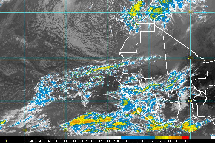
Strong tropical wave ssw of Cape Verde islands
Moderator: S2k Moderators
Forum rules
The posts in this forum are NOT official forecasts and should not be used as such. They are just the opinion of the poster and may or may not be backed by sound meteorological data. They are NOT endorsed by any professional institution or STORM2K. For official information, please refer to products from the National Hurricane Center and National Weather Service.
Be careful about recurvature, models are really starting to hint at the Bermuda high growing quite a lot and the troughs not being nearly as potent...so we shall see!
Anyway the issue with the GFS that needs to be watched is what it does with 92L.
That seems to have a huge role on what GFS does with this wave because instead of weakening it overland like the other models this powers it up as it goes extra-tropical overwater, that in turn induces quite a strong weakness which lifts this wave up a lot.
So in other words this one sis far from a done deal if it forms, though I think the timing means a recurver is more likely this time round, but watch over the next 2 weeks, big hints at the Bermuda high getting some muscles.
0 likes
- cycloneye
- Admin

- Posts: 149840
- Age: 69
- Joined: Thu Oct 10, 2002 10:54 am
- Location: San Juan, Puerto Rico
Re: Strong wave about to emerge from african coast
From 8 AM discussion.
THE ITCZ...
FROM 14N17W TO 14N30W TO 10N37W TO 6N50W 10N62W. ISOLATED
MODERATE SHOWERS TO LOCALLY STRONG THUNDERSTORMS FROM 7N TO 12N
BETWEEN 40W AND 60W. STRONG SHOWERS AND THUNDERSTORMS HAVE
EMERGED OFF THE AFRICA COAST FROM 12N TO 16N BETWEEN LAND AND
20W...POSSIBLY IN ADVANCE OF THE NEXT TROPICAL WAVE.
0 likes
- cycloneye
- Admin

- Posts: 149840
- Age: 69
- Joined: Thu Oct 10, 2002 10:54 am
- Location: San Juan, Puerto Rico
Re: Strong wave emerging from african coast
The models GFS.CMC,UKMET and ECMWF are more bullish with this wave today.
See models thread.
See models thread.
0 likes
- cycloneye
- Admin

- Posts: 149840
- Age: 69
- Joined: Thu Oct 10, 2002 10:54 am
- Location: San Juan, Puerto Rico
Re: Strong wave emerging from african coast
Wave is about to emerge completly into the water.Convection is not big,but has a nice structure and it continues to have the MLC.


0 likes
Re: Tropical wave emerging from african coast
Everybody is busy about invest 92L, but the other sytem just off the coast of Africa is organizing, nobody mention it today.
http://www.cancun.bz/frames/index.php?u ... n_sat1.php
http://www.cancun.bz/frames/index.php?u ... n_sat1.php
0 likes
- cycloneye
- Admin

- Posts: 149840
- Age: 69
- Joined: Thu Oct 10, 2002 10:54 am
- Location: San Juan, Puerto Rico
Re: Tropical wave emerging from african coast
I think TPC will introduce it at the 12 UTC surface analysis.
0 likes
- Fego
- S2K Supporter

- Posts: 767
- Age: 66
- Joined: Sun Apr 18, 2004 7:58 pm
- Location: San Juan, Puerto Rico
- Contact:
Re: Tropical wave emerging from african coast
Keep improving, in terms of convection... seems to me.
Loop:
http://oiswww.eumetsat.org/IPPS/html/MS ... /index.htm

Loop:
http://oiswww.eumetsat.org/IPPS/html/MS ... /index.htm

0 likes
- ConvergenceZone
- Category 5

- Posts: 5241
- Joined: Fri Jul 29, 2005 1:40 am
- Location: Northern California
Re: Strong tropical wave emerging from african coast
Agree. Sudden re-convecting is almost certain sign of next storm.
This is GFS system seen in projected models.
MJO no longer an issue. Conditions nearing peak season are sputtering on now on their own.
I suspect if MJO goes positive again we should see boom.
Now all we need is a big roller like Bill that tracks straight across and into Florida.
This is GFS system seen in projected models.
MJO no longer an issue. Conditions nearing peak season are sputtering on now on their own.
I suspect if MJO goes positive again we should see boom.
Now all we need is a big roller like Bill that tracks straight across and into Florida.
0 likes
Re: Strong tropical wave emerging from african coast
If they keep on coming off of Africa at 13 to 15n every one should recurve due to the nonexistance of a strong high this year.Also the progression of the east coast troughs also say recurve.
0 likes
-
lostsole
- Tropical Depression

- Posts: 55
- Age: 56
- Joined: Thu Aug 13, 2009 3:31 pm
- Location: Pensacola, FL
- Contact:
Re: Strong tropical wave emerging from african coast
Not sure about your statement Sanibel?? You are not hoping for a strike on FL right? I think you worded it incorrectly as I know you of all people know what a strike on Florida means, might catch some flak for that.
0 likes
- Evil Jeremy
- S2K Supporter

- Posts: 5463
- Age: 32
- Joined: Mon Apr 10, 2006 2:10 pm
- Location: Los Angeles, CA
-
otowntiger
- Category 5

- Posts: 1932
- Joined: Tue Aug 31, 2004 7:06 pm
Re:
/But I see it re-curving and quickly becoming very uninteresting..Evil Jeremy wrote:The focus has been on what is now Danny lately, but I think this is our next player. It is off the coast and not poofing, has nice convection and a nice structure. I think this will be invested by the end of the week.
0 likes
Re: Strong tropical wave emerging from african coast
If that September Bermuda High some are talking about happens a Bill like storm won't recurve and you know where that would send it...
0 likes
- Blown Away
- S2K Supporter

- Posts: 10253
- Joined: Wed May 26, 2004 6:17 am
Re: Re:
otowntiger wrote:/But I see it re-curving and quickly becoming very uninteresting..Evil Jeremy wrote:The focus has been on what is now Danny lately, but I think this is our next player. It is off the coast and not poofing, has nice convection and a nice structure. I think this will be invested by the end of the week.
Not sure what makes you think this is a recurve? Remember most of the hurricanes that effect the EC and specifically Florida come in September/October. Come September the BH starts to build and we get more long trackers. IMO, the timing of this wave will bring it near the Caribbean area in a week or so and I bet we see a stronger Bermuda High and a long tracker. Will it become a named storm, not sure, but it is a good looking wave rate now.
0 likes
- ConvergenceZone
- Category 5

- Posts: 5241
- Joined: Fri Jul 29, 2005 1:40 am
- Location: Northern California
Re: Re:
otowntiger wrote:/But I see it re-curving and quickly becoming very uninteresting..Evil Jeremy wrote:The focus has been on what is now Danny lately, but I think this is our next player. It is off the coast and not poofing, has nice convection and a nice structure. I think this will be invested by the end of the week.
it's still early, will need to wait and see
0 likes
Who is online
Users browsing this forum: No registered users and 42 guests


