ATL: TROPICAL DEPRESSION DANNY (05L)
Moderator: S2k Moderators


Re: ATL: Invest 92L
So what's the Pro Met prognosis at this time? this is happening so fast,,,,,
0 likes

Re: ATL: Invest 92L
Great analysis (as always) this evening from Dr. Jeff Masters....
The tropical wave (92L) a few hundred miles north of Puerto Rico is generating a large area of surface winds of 50 - 60 mph, according to the latest information from the Hurricane Hunters. Top winds seen so far at their flight level of 1,000 feet were 69 mph, which would make 92L a strong tropical storm if it had a surface circulation.
However, the aircraft has not found a surface circulation, and the satellite appearance shows virtually no change in the amount, intensity, or organization of the storm's thunderstorm activity.
Wind shear has dropped to the moderate range, 15 - 20 knots this afternoon, but the upper low 92L is moving underneath is dumping cold, dry air into the region. Dry air continues to get ingested into 92L's thunderstorms, creating strong downdrafts that are robbing 92L of heat and moisture. These downdrafts are creating surface arc clouds that spread out from where the downdraft hits the ocean surface. NHC continues to give 92L a high (greater than 50% chance) of developing into a tropical depression by Thursday afternoon.
As 92L moves underneath the center of the upper low on Wednesday morning, the upper low is expected to weaken, and wind shear is expected to decline to the low range, 5 - 10 knots. However, the upper-level low will continue to dump dry, cold air into 92L through Thursday afternoon, slowing down development. By Thursday night, when 92L should be several hundred miles off the coast of northern Florida, the upper-level low may be weak enough and far enough away that 92L will find itself in a region with light upper level anticyclonic winds, which would favor more rapid development.
However, this favorable environment will not last long, since a strong trough of low pressure will be approaching the U.S. East Coast on Friday. This trough will bring high wind shear of 20 - 30 knots by Friday night. This trough should be strong enough to turn 92L to the north. The models disagree substantially on how close 92L will be to the coast at that time. One camp of models, including the NOGAPS, Canadian, UKMET, and ECMWF models, predict 92L will pass very close to the Outer Banks of North Carolina on Friday night or Saturday morning. The GFS, GFDL, and HWRF models keep 92L several hundred miles out to sea. Both sets of models bring 92L north-northeastwards on Saturday, with a track over Massachusetts or Nova Scotia. The intensity forecast for 92L is problematic, since it's eventual strength depends upon how quickly it manages to become a tropical depression. Given that 92L will find itself in a favorable environment for strengthening for about 36 hours this week, and marginal for the remainder of the week, I give the system these odds:
10% chance of never getting a name.
20% chance of becoming a weak tropical storm (40 - 50 mph winds).
40% chance of becoming a strong tropical storm (55 - 70 mph winds).
30% chance of attaining hurricane strength.
Elsewhere in the Atlantic
The ECMWF and UKMET models predict the development of a tropical wave coming off the coast of Africa late this week. The GFS model no longer shows this.
I'll have an update Wednesday morning.
Jeff Masters
0 likes
-
HURAKAN

- Professional-Met

- Posts: 46084
- Age: 39
- Joined: Thu May 20, 2004 4:34 pm
- Location: Key West, FL
- Contact:
Re: ATL: Invest 92L
TROPICAL WEATHER DISCUSSION
NWS TPC/NATIONAL HURRICANE CENTER MIAMI FL
805 PM EDT TUE AUG 25 2009
...SPECIAL FEATURES...
A SURFACE TROUGH THAT HAS BROKEN AWAY FROM A TROPICAL WAVE IS E
OF THE SOUTHERN BAHAMAS ALONG 24N63W 23N67W 20N68W. SCATTERED
MODERATE CONVECTION IS IN CLUSTERS FROM 22N-24N BETWEEN
68W-69W...FROM 22N-26N BETWEEN 60W-66W...AND FROM 20N-22N
BETWEEN 60W-63W. GALE FORCE WINDS ARE OVER A SMALL AREA WITHIN
150 NM NE SEMICIRCLE OF 23N67W. A RECONNAISSANCE AIRCRAFT FOUND
60 KT WINDS AT A FLIGHT LEVEL OF 900 FT...BUT DID NOT FIND A
CLOSED LOW LEVEL CENTER. THIS SYSTEM CONTINUES TO SHOW SIGNS OF
ORGANIZATION...AND UPPER-LEVEL WINDS ARE FORECAST TO BECOME MORE
CONDUCIVE FOR DEVELOPMENT DURING THE NEXT DAY OR SO AS THE
SYSTEM MOVES WEST-NORTHWESTWARD AROUND 17 KT. THERE IS A HIGH
CHANCE OF THIS SYSTEM BECOMING A TROPICAL DEPRESSION OR TROPICAL
STORM DURING THE NEXT 48 HOURS.
0 likes
-
cycloneye

- Admin

- Posts: 149305
- Age: 69
- Joined: Thu Oct 10, 2002 10:54 am
- Location: San Juan, Puerto Rico
Re: ATL: Invest 92L
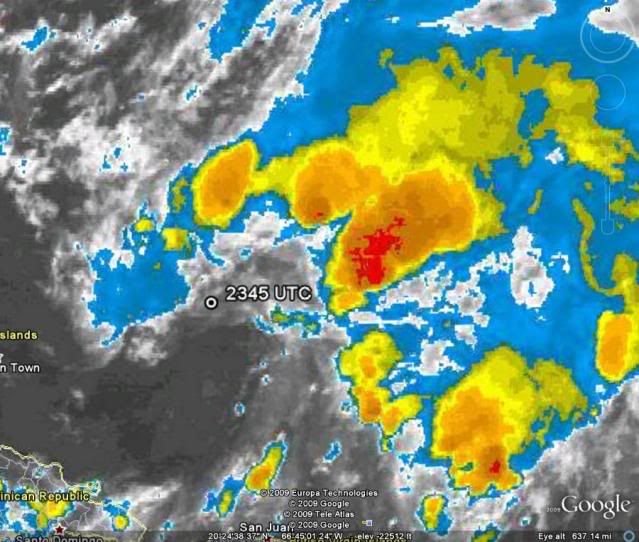
Aric,I think you will like this SSD dvorak position better than the afternoon one. 
25/2345 UTC 22.5N 67.1W T1.5/1.5 92L -- Atlantic
http://www.ssd.noaa.gov/PS/TROP/tdpositions.html
25/2345 UTC 22.5N 67.1W T1.5/1.5 92L -- Atlantic
http://www.ssd.noaa.gov/PS/TROP/tdpositions.html
0 likes
-
Aric Dunn
- Category 5

- Posts: 21238
- Age: 43
- Joined: Sun Sep 19, 2004 9:58 pm
- Location: Ready for the Chase.
- Contact:
Re: ATL: Invest 92L
cycloneye wrote:Aric,I think you will like this SSD dvorak position better than the afternoon one.
25/2345 UTC 22.5N 67.1W T1.5/1.5 92L -- Atlantic
hehe.. yeah thats quite a bit better... the earlier one was what 64w ,.. thats only a near 200 miles improvement .
if recon does fly tonight .. i hope they decide to fly around 70 west..
Last edited by Aric Dunn on Tue Aug 25, 2009 7:40 pm, edited 1 time in total.
0 likes
-
CrazyC83
- Professional-Met
- Posts: 34315
- Joined: Tue Mar 07, 2006 11:57 pm
- Location: Deep South, for the first time!
10% chance of never getting a name.
20% chance of becoming a weak tropical storm (40 - 50 mph winds).
40% chance of becoming a strong tropical storm (55 - 70 mph winds).
30% chance of attaining hurricane strength.
I'd say the chances are 40, zero, 30 and 30. It cannot become a weak TS since the winds are beyond that now.
20% chance of becoming a weak tropical storm (40 - 50 mph winds).
40% chance of becoming a strong tropical storm (55 - 70 mph winds).
30% chance of attaining hurricane strength.
I'd say the chances are 40, zero, 30 and 30. It cannot become a weak TS since the winds are beyond that now.
0 likes
-
hurricanefloyd5

- Category 5
- Posts: 1659
- Age: 45
- Joined: Sun May 02, 2004 10:53 am
- Location: Spartanburg
- Contact:
Re: ATL: Invest 92L
Aric Dunn wrote:cycloneye wrote:Aric,I think you will like this SSD dvorak position better than the afternoon one.
25/2345 UTC 22.5N 67.1W T1.5/1.5 92L -- Atlantic
hehe.. yeah thats quite a bit better...
if recon does fly tonight .. i hope they decide to fly around 70 west..
Will this bring the storm abbit cloaser to florida's coastline? I hope not
0 likes
-
Aric Dunn
- Category 5
- Posts: 21238
- Age: 43
- Joined: Sun Sep 19, 2004 9:58 pm
- Location: Ready for the Chase.
- Contact:
Re: ATL: Invest 92L
hurricanefloyd5 wrote:Aric Dunn wrote:cycloneye wrote:Aric,I think you will like this SSD dvorak position better than the afternoon one.
25/2345 UTC 22.5N 67.1W T1.5/1.5 92L -- Atlantic
hehe.. yeah thats quite a bit better...
if recon does fly tonight .. i hope they decide to fly around 70 west..
Will this bring the storm abbit cloaser to florida's coastline? I hope not
the weaker it stays the more west it will go.. that and the models are doing a very bad job right now. except the euro and ukmet.. with initial position and motion. throw the rest out..
0 likes
-
Derek Ortt
-
Aric Dunn
- Category 5
- Posts: 21238
- Age: 43
- Joined: Sun Sep 19, 2004 9:58 pm
- Location: Ready for the Chase.
- Contact:
hehe ...
look at the difference..
25/2345 UTC 22.5N 67.1W T1.5/1.5 92L
25/1745 UTC 23.3N 64.8W T1.5/1.5 92L
they shifted it SW from its original position by about 200 miles. .
well 152.145 miles to be exact to the SW .. lol
look at the difference..
25/2345 UTC 22.5N 67.1W T1.5/1.5 92L
25/1745 UTC 23.3N 64.8W T1.5/1.5 92L
they shifted it SW from its original position by about 200 miles. .
well 152.145 miles to be exact to the SW .. lol
Last edited by Aric Dunn on Tue Aug 25, 2009 7:47 pm, edited 2 times in total.
0 likes
Re: ATL: Invest 92L - Computer Models
Code: Select all
WHXX01 KWBC 260040
CHGHUR
TROPICAL CYCLONE GUIDANCE MESSAGE
NWS TPC/NATIONAL HURRICANE CENTER MIAMI FL
0040 UTC WED AUG 26 2009

DISCLAIMER...NUMERICAL MODELS ARE SUBJECT TO LARGE ERRORS.
PLEASE REFER TO NHC OFFICIAL FORECASTS FOR TROPICAL CYCLONE
AND SUBTROPICAL CYCLONE INFORMATION.

ATLANTIC OBJECTIVE AIDS FOR

DISTURBANCE INVEST (AL922009) 20090826 0000 UTC

        ...00 HRS...   ...12 HRS...   ...24 HRS. ..   ...36 HRS...
        090826  0000   090826  1200   090827  0000   090827  1200

         LAT    LON     LAT    LON     LAT    LON     LAT    LON
BAMS    23.3N  66.7W   24.9N  69.5W   26.4N  71.6W   27.6N  73.2W
BAMD    23.3N  66.7W   24.8N  68.7W   26.1N  70.5W   27.1N  72.0W
BAMM    23.3N  66.7W   24.7N  68.9W   26.1N  70.7W   27.3N  72.1W
LBAR    23.3N  66.7W   24.9N  68.9W   26.5N  70.6W   27.9N  72.2W
SHIP        40KTS          49KTS          58KTS          65KTS
DSHP        40KTS          49KTS          58KTS          65KTS

        ...48 HRS...   ...72 HRS...   ...96 HRS. ..   ..120 HRS...
        090828  0000   090829  0000   090830  0000   090831  0000

         LAT    LON     LAT    LON     LAT    LON     LAT    LON
BAMS    28.9N  74.2W   31.8N  74.7W   35.8N  69.8W   39.8N  60.1W
BAMD    28.2N  73.2W   32.7N  73.4W   39.0N  67.5W   44.3N  52.6W
BAMM    28.6N  73.1W   32.6N  73.2W   38.1N  67.8W   42.9N  55.3W
LBAR    29.3N  72.9W   33.0N  72.5W   38.0N  68.0W   42.7N  54.3W
SHIP        72KTS          84KTS          90KTS          73KTS
DSHP        72KTS          84KTS          90KTS          73KTS

         ...INITIAL CONDITIONS...
LATCUR =  23.3N LONCUR =  66.7W DIRCUR = 300DEG SPDCUR =  16KT
LATM12 =  21.7N LONM12 =  63.3W DIRM12 = 310DEG SPDM12 =  20KT
LATM24 =  18.4N LONM24 =  59.9W
WNDCUR =   40KT RMAXWD =  120NM WNDM12 =   25KT
CENPRS = 1010MB OUTPRS = 1012MB OUTRAD =  150NM SDEPTH =   M
RD34NE =  120NM RD34SE =    0NM RD34SW =    0NM RD34NW =   0NM

$$
NNNN
0 likes
Re: ATL: Invest 92L
00Z best track:
AL, 92, 2009082600, , BEST, 0, 233N, 667W, 40, 1010, DB, 34, NEQ, 120, 0, 0, 0, 1012, 150, 120, 0, 0, L, 0, , 0, 0, INVEST, M,
AL, 92, 2009082600, , BEST, 0, 233N, 667W, 40, 1010, DB, 34, NEQ, 120, 0, 0, 0, 1012, 150, 120, 0, 0, L, 0, , 0, 0, INVEST, M,
0 likes
As the trough starts to pull 92L I guess Derek I guess?
Wouldn't actually surprise me that much given there have been a number of systems in a similar synoptic pattern that managed to make it to major status by 35N, so one to watch, don't think it will get that strong but hurricane strength seems possible I agree.
Also still doesn't appear to have a proper center right now, I think we will see several eddies try to dominate over the next 12-24hrs.
Last edited by KWT on Tue Aug 25, 2009 7:46 pm, edited 1 time in total.
0 likes
-
cycloneye
- Admin
- Posts: 149305
- Age: 69
- Joined: Thu Oct 10, 2002 10:54 am
- Location: San Juan, Puerto Rico
Re: ATL: Invest 92L
Derek,why there are different positions from SSD dvorak and Best Track?
SSD=22.5N 67.1W
Best Track=23.3N-66.7W
SSD=22.5N 67.1W
Best Track=23.3N-66.7W
0 likes
Re:
It could absolutely become a depression if it gets organized....thunderstorms build and wane all the time in systems....the winds that the hurricane hunters found were in strong cells....it doesn't have an organized wind field like you would see with a ts or hurricane. I don't think the winds they found were 'sustained' or organized....and developing systems pulse and wane several times a day. If it starts to organize like you would see with a developing system, the internal structure could change from that of random strong storms to systematic and organized convection.
CrazyC83 wrote:10% chance of never getting a name.
20% chance of becoming a weak tropical storm (40 - 50 mph winds).
40% chance of becoming a strong tropical storm (55 - 70 mph winds).
30% chance of attaining hurricane strength.
I'd say the chances are 40, zero, 30 and 30. It cannot become a weak TS since the winds are beyond that now.
Last edited by jinftl on Tue Aug 25, 2009 7:48 pm, edited 1 time in total.
0 likes
-
Ivanhater

- Storm2k Moderator

- Posts: 11221
- Age: 39
- Joined: Fri Jul 01, 2005 8:25 am
- Location: Pensacola
Re:
Derek Ortt wrote:Ortt's first call
hurricane by Friday
Now that's what I call making a bold forecast! Props for putting your neck out Derek
Probably going to get even busier for you with the model support of the African system and the subtropical ridge building in...
0 likes
Who is online
Users browsing this forum: No registered users and 13 guests