
What a messy system, looks like its still interacting quite heavily with the ULL. Has got the wind strength of a tropical storm so if it does develop a closed circulation its going to be upgraded to Danny right away.
Tricky one this one!
ATL: TROPICAL DEPRESSION DANNY (05L)
Moderator: S2k Moderators
-
x-y-no

- Category 5

- Posts: 8359
- Age: 65
- Joined: Wed Aug 11, 2004 12:14 pm
- Location: Fort Lauderdale, FL
Second dropsonde from NOAA flight (25.7N 69.8W)
UZNT13 KWBC 252229
XXAA 75222 99257 70698 07959 99015 28050 06016 00132 27048 07015
92817 22658 10518 85547 17456 06515 70184 08240 07535 50588 09114
08024 40757 19103 10012 30967 32362 27510 25093 42163 29004 20240
531// 03510 88999 77999
31313 09608 82142
51515 10190 15421
61616 NOAA9 WXWXA AL92 OB 02
62626 SPL 2565N06989W 2156 MBL WND 07514 AEV 20801 DLM WND 07012
014167 WL150 06014 083 REL 2566N06984W 214244 SPG 2565N06989W 215
642 =
XXBB 75228 99257 70698 07959 00015 28050 11948 23031 22921 22458
33850 17456 44820 15635 55740 12057 66682 06230 77653 04250 88603
00133 99587 02112 11559 02937 22538 05504 33500 09115 44495 09313
55484 09357 66478 09556 77473 10125 88457 12156 99428 15504 11395
19706 22385 19936 33363 22943 44355 23963 55349 24766 66304 31760
77284 34367 88213 49766 99167 60158
21212 00015 06016 11006 06013 22948 09013 33925 10518 44877 11015
55850 06515 66746 06028 77695 08035 88477 07513 99452 10014 11420
11011 22397 10012 33387 08010 44345 31510 55332 27014 66312 26017
77300 27510 88290 25014 99279 28013 11272 28012 22232 16503 33216
13010 44201 03510 55196 03012 66167 04040
31313 09608 82142
51515 10190 15421
61616 NOAA9 WXWXA AL92 OB 02
62626 SPL 2565N06989W 2156 MBL WND 07514 AEV 20801 DLM WND 07012
014167 WL150 06014 083 REL 2566N06984W 214244 SPG 2565N06989W 215
642 =
0 likes
-
BensonTCwatcher

- Category 5
- Posts: 1050
- Joined: Sat Aug 28, 2004 10:11 pm
- Location: Southport NC
Re: ATL: Invest 92L
Sanibel wrote:Hurakan's NHC report puts the center in the west yellow circle rotation.
If that is the forming center it is much further south and west-heading than the models show.
Which is why I think it is the 23.8-65 center.
That seems about right maybe even closer to 66W gonna loose the visible sat as the LLC forms
0 likes
-
storms NC

- Tropical Storm

- Posts: 247
- Age: 70
- Joined: Tue Sep 14, 2004 2:41 pm
- Location: Coast of NC & southwest coast of Fla
Re: ATL: Invest 92L
Sanibel wrote:Hurakan's NHC report puts the center in the west yellow circle rotation.
If that is the forming center it is much further south and west-heading than the models show.
Which is why I think it is the 23.8-65 center.
I am with you. That is what I see.
0 likes
Re: ATL: Invest 92L
The main convection is tied to the 23.8N-65W center or the "blue circle" center. Keep watching, the center will form out of this center that little slow-tracking center burst is moving directly in timing with. The curved convection is also in synch with it. NHC should know better than to list the 67W position as the center simply because it is moving west not NW as they said.
0 likes


Re: ATL: Invest 92L
Long before this could ever be a gulf threat, it would have to be florida's problem to deal with...simple geography. As a rule of thumb, if there isn't much talk of this being a florida threat, folks in the Gulf have nothing to worry about at all. Right now, this is not a florida threat.
rrm wrote:any chance this gets in the gom?
0 likes
-
storms NC
- Tropical Storm
- Posts: 247
- Age: 70
- Joined: Tue Sep 14, 2004 2:41 pm
- Location: Coast of NC & southwest coast of Fla
Re:
KWT wrote:What a messy system, looks like its still interacting quite heavily with the ULL. Has got the wind strength of a tropical storm so if it does develop a closed circulation its going to be upgraded to Danny right away.
Tricky one this one!
I think the ULL is move away from this. I think that is what it has to do with the strong winds
0 likes
Re: ATL: Invest 92L
Anyone have a Quick Scat?
On second thought Q-Scat tends to miss these types.
On second thought Q-Scat tends to miss these types.
0 likes
-
cycloneye

- Admin

- Posts: 149304
- Age: 69
- Joined: Thu Oct 10, 2002 10:54 am
- Location: San Juan, Puerto Rico
Re: ATL : Invest 92L - Recon Thread
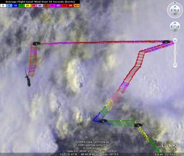
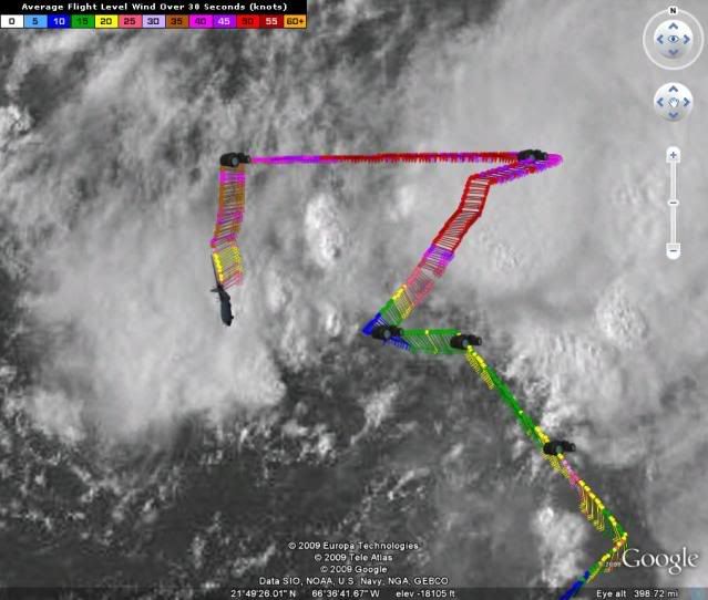
ENE to NE winds.
URNT15 KNHC 252250
AF302 01AAA INVEST HDOB 25 20090825
224030 2354N 06736W 9767 00310 0123 +208 +151 070046 046 043 005 00
224100 2353N 06737W 9773 00305 0122 +211 +151 071041 043 042 004 03
224130 2351N 06737W 9767 00309 0120 +215 +152 064037 038 040 001 03
224200 2350N 06736W 9776 00301 0121 +207 +154 064036 038 040 002 03
224230 2348N 06736W 9776 00300 0119 +216 +156 065031 032 036 003 00
224300 2347N 06735W 9772 00304 0118 +218 +158 065027 028 033 004 00
224330 2345N 06735W 9771 00303 0118 +220 +161 064024 025 029 001 00
224400 2344N 06734W 9774 00300 0117 +221 +164 060023 023 029 001 00
224430 2342N 06734W 9769 00305 0117 +221 +167 058022 023 029 002 00
224500 2341N 06733W 9768 00306 0117 +221 +170 058022 023 027 004 00
224530 2339N 06733W 9771 00303 0117 +220 +172 059023 023 028 002 00
224600 2338N 06732W 9770 00303 0116 +222 +174 059023 024 028 003 00
224630 2336N 06732W 9770 00302 0116 +221 +176 056024 025 029 003 00
224700 2334N 06732W 9772 00301 0115 +220 +177 057025 025 030 002 00
224730 2333N 06731W 9772 00300 0114 +223 +178 059024 024 030 002 00
224800 2331N 06731W 9768 00303 0114 +223 +179 057024 025 029 003 00
224830 2329N 06731W 9773 00297 0112 +224 +180 054025 025 031 003 00
224900 2328N 06731W 9772 00298 0111 +225 +181 054025 026 030 004 00
224930 2326N 06731W 9769 00300 0111 +225 +182 055025 025 032 002 00
225000 2324N 06731W 9770 00300 0112 +221 +182 059026 027 034 007 00
0 likes
-
southerngale

- Retired Staff

- Posts: 27418
- Joined: Thu Oct 10, 2002 1:27 am
- Location: Southeast Texas (Beaumont area)
Re: ATL: Invest 92L
Evil Jeremy wrote:rrm wrote:that sounds good maybe our high school football season wont be messed up this year
If a storm was in the gulf, the prime area for intensification, the last thing I would be worrying about would be high school football. You would be lucky to even have high school for weeks after a direct hurricane hit lol.
Yeah, that's what I was thinking. After the destruction here caused by Rita and then Ike (not to mention Humberto), I think the last thing on anyone's mind was high school football.
 I think surviving and then picking up the pieces are pretty high up there, though.
Hopefully, this one won't cause any major problems for anyone.
0 likes
-
BensonTCwatcher
- Category 5
- Posts: 1050
- Joined: Sat Aug 28, 2004 10:11 pm
- Location: Southport NC
Re: ATL: Invest 92L
I'm just looking at the lowest level cloud patterns RGB channel shortwave and visible loops and it's not closed off yet but recon may find otherwise. It could be very close. as the ULL looses influence it will though I think sharp wave with a lot of energy and warm water and vorticity looks to be increasing too. Strange brew nonetheless
0 likes

Re: ATL: Invest 92L
I haven't read all the recon but I didn't t see anything westerly yet, just broad hint of circulation. I first guessed it might focus down around 21.2 and 67W. But it's hard to ignore the convection and say around 23N 65W is more likely.
I don't like anything in this location, though everyone seems certain about a trough steering it northward.
I don't like anything in this location, though everyone seems certain about a trough steering it northward.
0 likes
Re: ATL: Invest 92L
replace 'certain' with 'confident'...there are no certainties when it comes to Mother Nature....esp being 'certain' about a system that hasn't even formed yet
Recurve wrote:I haven't read all the recon but I didn't t see anything westerly yet, just broad hint of circulation. I first guessed it might focus down around 21.2 and 67W. But it's hard to ignore the convection and say around 23N 65W is more likely.
I don't like anything in this location, though everyone seems certain about a trough steering it northward.
0 likes
Re: ATL: Invest 92L
Sanibel wrote:Anyone have a Quick Scat?
On second thought Q-Scat tends to miss these types.
Pass log on NRL shows that the pass this evening will be another miss (988 km CPA). Should have a good pass tomorrow morning. However, that could be besides the point if the early morning recon flight goes as scheduled.
0 likes

Re: ATL: Invest 92L
yeah your right it is not my top priority but it is something i love and wait for all year and the last thing i want is to have it screwed up again
0 likes
-
Derek Ortt
Who is online
Users browsing this forum: No registered users and 117 guests