000
WTNT34 KNHC 161139
TCPAT4
BULLETIN
TROPICAL DEPRESSION FOUR INTERMEDIATE ADVISORY NUMBER 1A
NWS TPC/NATIONAL HURRICANE CENTER MIAMI FL AL042009
800 AM EDT SUN AUG 16 2009
...DEPRESSION MOVING NORTH-NORTHWESTWARD...HEADING FOR THE NORTHERN
GULF COAST OF FLORIDA...
A TROPICAL STORM WARNING REMAINS IN EFFECT FROM THE ALABAMA/FLORIDA
BORDER EASTWARD TO THE SUWANNEE RIVER FLORIDA. A TROPICAL STORM
WARNING MEANS THAT TROPICAL STORM CONDITIONS ARE EXPECTED SOMEWHERE
WITHIN THE WARNING AREA WITHIN 24 HOURS.
FOR STORM INFORMATION SPECIFIC TO YOUR AREA PLEASE MONITOR PRODUCTS
ISSUED BY YOUR LOCAL NATIONAL WEATHER SERVICE FORECAST OFFICE.
AT 800 AM EDT...1200 UTC...THE CENTER OF TROPICAL DEPRESSION FOUR
WAS LOCATED NEAR LATITUDE 28.1 NORTH...LONGITUDE 84.1 WEST OR ABOUT
125 MILES...200 KM...SOUTH-SOUTHEAST OF APALACHICOLA FLORIDA.
THE DEPRESSION IS MOVING TOWARD THE NORTH-NORTHWEST NEAR 16
MPH...AND THIS MOTION IS EXPECTED TO CONTINUE TODAY. ON THE
FORECAST TRACK...THE CENTER OF THE DEPRESSION SHOULD BE VERY NEAR
THE NORTHERN GULF COAST OF FLORIDA BY LATE THIS AFTERNOON.
MAXIMUM SUSTAINED WINDS ARE NEAR 35 MPH...55 KM/HR...WITH HIGHER
GUSTS. STRENGTHENING IS EXPECTED AND THE DEPRESSION IS FORECAST TO
BECOME A TROPICAL STORM PRIOR TO REACHING THE COASTLINE.
ESTIMATED MINIMUM CENTRAL PRESSURE IS 1011 MB...29.85 INCHES.
RAINFALL ACCUMULATIONS OF 3 TO 5 INCHES...WITH ISOLATED MAXIMUM
AMOUNTS OF 10 INCHES ACROSS PORTIONS OF NORTH FLORIDA NEAR THE PATH
OF THE CENTER.
COASTAL STORM SURGE FLOODING OF 3 TO 5 FEET ABOVE NORMAL TIDE
LEVELS CAN BE EXPECTED NEAR AND TO THE EAST OF WHERE THE CENTER
MAKES LANDFALL.
...SUMMARY OF 800 AM EDT INFORMATION...
LOCATION...28.1N 84.1W
MAXIMUM SUSTAINED WINDS...35 MPH
PRESENT MOVEMENT...NORTH-NORTHWEST OR 330 DEGREES AT 16 MPH
MINIMUM CENTRAL PRESSURE...1011 MB
THE NEXT ADVISORY WILL BE ISSUED BY THE NATIONAL HURRICANE CENTER AT
1100 AM EDT.
$$
FORECASTER BRENNAN/ROBERTS
ATL: TROPICAL DEPRESSION CLAUDETTE (04L)
Moderator: S2k Moderators


-
dixiebreeze

- S2K Supporter

- Posts: 5140
- Joined: Wed Sep 03, 2003 5:07 pm
- Location: crystal river, fla.

Re:
Aric Dunn wrote:just found out ...for sure.. im heading out in about an hour to Apalachicola to chase...im excited... dont why its only my 8 chase but this one seems funner .. lol
Oysters!
0 likes
-
dixiebreeze
- S2K Supporter
- Posts: 5140
- Joined: Wed Sep 03, 2003 5:07 pm
- Location: crystal river, fla.
Re: ATL: TROPICAL DEPRESSION FOUR (04L)
Hoping potential "Claudette" doesn't decide to stall right off the Big Bend area. Flooding could be a major problem along our coast.
0 likes
-
wxman57

- Moderator-Pro Met

- Posts: 23175
- Age: 68
- Joined: Sat Jun 21, 2003 8:06 pm
- Location: Houston, TX (southwest)
Re: ATL: TROPICAL DEPRESSION FOUR (04L)
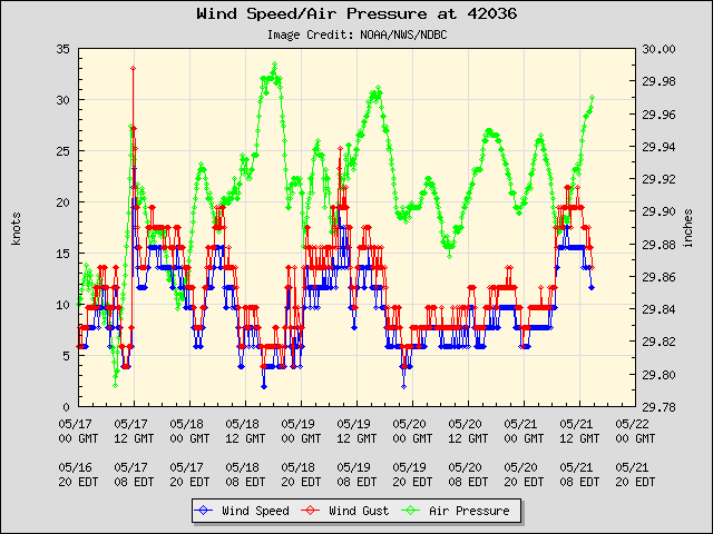
Just 10 miles SE of buoy 42036 and the buoy has NE wind 10-12 kts. The NE wind indicates that there might be an LLC. Will be interesting to see if the buoy wind goes SW after it passes.
http://www.ndbc.noaa.gov/station_page.php?station=42036
http://www.ndbc.noaa.gov/station_page.php?station=42036
0 likes
-
cycloneye
- Admin

- Posts: 149730
- Age: 69
- Joined: Thu Oct 10, 2002 10:54 am
- Location: San Juan, Puerto Rico
Re: ATL: TROPICAL DEPRESSION FOUR (04L)
Still a TD at the 12 UTC Best Track
AL, 04, 2009081612, , BEST, 0, 282N, 842W, 30, 1011, TD
ftp://ftp.tpc.ncep.noaa.gov/atcf/tcweb/ ... 009.invest
AL, 04, 2009081612, , BEST, 0, 282N, 842W, 30, 1011, TD
ftp://ftp.tpc.ncep.noaa.gov/atcf/tcweb/ ... 009.invest
0 likes


-
MiamiensisWx
Re: ATL: TROPICAL DEPRESSION FOUR (04L)
The posts in this forum are NOT official forecast and should not be used as such. They are just the opinion of the poster and may or may not be backed by sound meteorological data. They are NOT endorsed by any professional institution or storm2k.org. For official information, please refer to the NHC and NWS products.
Personally, I'm not sure as to why a reconnaissance mission hasn't been assigned for this system, although I'm certainly not disputing the difficulties and intricacies of arranging a mission. I must also state that their available missions are greatly appreciated. Nevertheless, I'm typically accustomed to the existence of at least one flight for an imminent land threat (for the Caribbean, Bermuda, and CONUS). The fact that the system is projected to attain TS intensity augments my curiosity. Furthermore, the official initial intensity is 30 kt, and TBW (Tampa Bay) radar indicates that the organization is improving. Note that banding features are becoming more defined, including a prominent curved band immediately east of the center of circulation. Earlier, Navy-2 Buoy 42013, located southwest of Sarasota, reported sustained winds of 25 kt/30 mph and gusts of 30 kt/35 mph, respectively. The center has been moving farther away from the station, contributing to the recent pressure increases at this location. Thus, the need for caution and accurate intensity documentation would appear to be necessary. Regardless, I think it is quite possible that the system does not exceed 35 kt/40 mph at its peak intensity.
Specifically, note that radar suggests the outer bands' reflectivity is currently increasing, while the reflectivity and base velocities near the center are decreasing. This trend tends to contradict the other signs of organization in a favorable upper air environment, which is currently characterized by light winds at all levels and anticyclonic flow. The reflectivity trends suggest that mid level dry air may be entering the system from the south and northwest. A recent 700 mb analysis shows lower dewpoints south and west of the center. Note that satellite images indicate that the center is located near the western edge of the convection. As the system approaches the coast of northwest Florida, it will encounter favorable increasing upper level divergence, which will aid convection. However, as it approaches the northern edge of the upper level anticyclone, it will encounter some increasing upper level shear. Thus, another factor will likely limit TD 4's intensity.
In summation, I think that the NHC's forecast intensity is too high.
0 likes
-
tolakram
- Admin
- Posts: 20186
- Age: 62
- Joined: Sun Aug 27, 2006 8:23 pm
- Location: Florence, KY (name is Mark)
Re: ATL: TROPICAL DEPRESSION FOUR (04L)
Rapid scan site:
http://rammb.cira.colostate.edu/ramsdis/online/rso.asp
Hopefully they'll put a floater over it.
It appears new convection is organizing around the supposed center.

Flash Loop
http://www.ssd.noaa.gov/goes/flt/t3/flash-avn.html
and pressure continues to drop at the buoy.
http://www.ndbc.noaa.gov/station_page.php?station=42036
Wind shifting

http://rammb.cira.colostate.edu/ramsdis/online/rso.asp
Hopefully they'll put a floater over it.
It appears new convection is organizing around the supposed center.
Flash Loop
http://www.ssd.noaa.gov/goes/flt/t3/flash-avn.html
and pressure continues to drop at the buoy.
http://www.ndbc.noaa.gov/station_page.php?station=42036
Wind shifting
Last edited by tolakram on Sun Aug 16, 2009 8:07 am, edited 2 times in total.
0 likes
-
attallaman
Re: ATL: TROPICAL DEPRESSION FOUR (04L)
How far west might this system go before it makes landfall as it stands now? Mobile, AL? Will I receive anything out of this system here along the MS Gulf Coast?
0 likes

-
Frank P
- S2K Supporter
- Posts: 2779
- Joined: Fri Aug 29, 2003 10:52 am
- Location: Biloxi Beach, Ms
- Contact:
Re: ATL: TROPICAL DEPRESSION FOUR (04L)
attallaman wrote:How far west might this system go before it makes landfall as it stands now? Mobile, AL? Will I receive anything out of this system here along the MS Gulf Coast?
As it goes right now, and because its so small.. don't expect much at all along the MS coast from the TD, unless it were to change course and move more westerly, which is unlikely at this time... storms we are getting right now are not related to the TD..
0 likes
-
Dionne

- S2K Supporter
- Posts: 1616
- Age: 74
- Joined: Mon Jan 02, 2006 8:51 am
- Location: SW Mississippi....Alaska transplant via a Southern Belle.
Re: ATL: TROPICAL DEPRESSION FOUR (04L)
TWC is forecasting TS Claudette before landfall. Last transmit from 42036 showing a slight drop in pressure, with winds well below TS threshold.
0 likes
-
Frank P
- S2K Supporter
- Posts: 2779
- Joined: Fri Aug 29, 2003 10:52 am
- Location: Biloxi Beach, Ms
- Contact:
Re: ATL: TROPICAL DEPRESSION FOUR (04L)
Sat loop shows convection trying to build around the small center...it looks to me that the last shot has the center right on line...
http://my.sfwmd.gov/portal/page?_pageid ... ema=PORTAL
http://my.sfwmd.gov/portal/page?_pageid ... ema=PORTAL
0 likes
Who is online
Users browsing this forum: No registered users and 31 guests