South Florida forecaster thinks recurve is not gonna happen...
A TROPICAL WAVE WILL MOVE THROUGH THE FLORIDA KEYS TODAY. A STRONG ATLANTIC HIGH PRESSURE RIDGE WILL BUILD ACROSS THE SOUTHEASTERN UNITED STATES TONIGHT AND SUNDAY...THEN REMAIN IN PLACE THROUGH WEDNESDAY. TROPICAL STORM ANA MAY MOVE THROUGH THE BAHAMAS OR POSSIBLY NEAR THE FLORIDA KEYS DURING THE MIDDLE OF NEXT WEEK.
With that set up don't see how ANA will make it north of the bahamas. Could be a possible Andrew type track? Not strength just movement! Then into the gulf, perhaps?
ATL: TROPICAL DEPRESSION ANA (02L)
Moderator: S2k Moderators
-
CYCLONE MIKE
- Category 5

- Posts: 2183
- Joined: Tue Aug 31, 2004 6:04 pm
- Location: Gonzales, LA
-
MusicCityMan

- Category 1

- Posts: 483
- Joined: Sat Feb 17, 2007 10:57 pm
- Location: Somewhere in Central Florida
Avila knew we'd all be asleep, that's why he issued it lol. NE way.. I'm curious to see if traffic will begin to pick up at my job today in regards to hurricane supplies, considering local mets are already starting to jump on this.
Y'all know my "bring it on" attitude regarding these storms. Lets see what happens. I personally think a strong TS off the coast at the end of the 5 day is a little low.. based on how these storms typically tend to blow up.
Y'all know my "bring it on" attitude regarding these storms. Lets see what happens. I personally think a strong TS off the coast at the end of the 5 day is a little low.. based on how these storms typically tend to blow up.
0 likes
-
Gustywind

- Category 5
- Posts: 12334
- Joined: Mon Sep 03, 2007 7:29 am
- Location: Baie-Mahault, GUADELOUPE

000
FXCA62 TJSJ 151004
AFDSJU
AREA FORECAST DISCUSSION
NATIONAL WEATHER SERVICE SAN JUAN PR
604 AM AST SAT AUG 15 2009
IMPORTANT CHANGES HAS BEEN OCCURRING ACROSS THE TROPICAL ATLANTIC
THE LAST 12 HOURS. TROPICAL STORM ANA...THE FIRST NAMED STORM OF
THE 2009 HURRICANE SEASON IS BORN. AT 5:00 AM AST THIS
MORNING...THE CENTER OF TROPICAL STORM ANA WAS LOCATED ABOUT 1300 MILES
EAST SOUTHEAST OF PUERTO RICO. LATEST NHC OFFICIAL TRACK...PASS ANA
BETWEEN 35-50 MILES NORTHEAST OF PUERTO RICO ON MONDAY. UPPER
LEVEL RIDGE NORTH OF ANA...WILL MAINTAIN THE SYSTEM MOVING ON A
WESTWARD TRACK AT LEAST THE NEXT 24 TO 36 HOURS. LATER...SOME
COMPUTER MODELS SUGGEST THIS RIDGE WILL WEAKEN A
LITTLE...PRODUCING A MORE WEST TO NORTHWEST TRACK OF THE STORM. IF
THIS NOT HAPPEN...THEN...THE TROPICAL STORM WILL MOVE FURTHER
SOUTH...AND THE SYSTEM COULD IMPACT THE LOCAL AREA MORE STRONGER.
IN ANY WAYS...ANA IS EXPECTED TO PASS CLOSE ENOUGH FROM OUR
FORECAST AREA...TO PRODUCED A SIGNIFICANT INCREASE IN SHOWER AND
THUNDERSTORMS ACTIVITY ON MONDAY.
BEHIND TROPICAL STORM ANA...ANOTHER SYSTEM...A VERY STRONG
TROPICAL WAVE...HAVE A HIGH CHANCE TO BECOME A TROPICAL DEPRESSION
LATER TODAY. LATEST COMPUTER MODELS SUGGEST THAT THIS SYSTEM WILL
TRACK WESTWARD FOR THE NEXT 3 DAYS. AFTER THAT...MAINLY WHEN THE
SYSTEM REACH 50 DEGREES WEST LONGITUDE...THE SYSTEM WILL MOVE IN A MORE
NORTHWESTERLY TRACK...PASSING THE CENTER NEAR 150 MILES NORTHEAST
OF THE LOCAL AREA. LOOKS LIKE THE MODELS SUGGESTS THAT THIS
DEVELOPING SYSTEM WILL MOVE SLOWER...AND ALSO WILL BE LESS
STRONGER...THAN PREVIOUS COMPUTER MODEL RUNS. A WEAKNESS IN THE
MID LEVEL RIDGE...IF FORECAST BY MOST OF THE COMPUTER MODELS IN THE
LONG RANGE NORTHWEST OF THE LOCAL AREA. IF THE SYSTEM MOVE
SLOWER...IT WILL REACH THE WEAKNESS BY THAT TIME...AND WILL TEND
TO MOVE MORE ON A NORTHWESTERLY COMPONENT. HOWEVER...IF THE SYSTEM
MOVE FASTER THAN INDICATED BY THE MODELS...THE RIDGE WILL BE
INTACT AND MORE STRONGER WHICH WILL ALLOW THE SYSTEM TO MOVE
CLOSER TO THE LOCAL AREA.
DUE TO THIS UNCERTAINTY IN THE FUTURE TRACKS OF BOTH SYSTEMS...RESIDENTS
OF PR AND THE USVI ARE ENCOURAGED TO MONITOR LATEST FORECASTS FROM
THE NATIONAL HURRICANE CENTER OVER THE WEEKEND AND GO OVER THEIR
HURRICANE DISASTER PLANS IN CASE THE THREAT FROM THESE TWO
TROPICAL SYSTEMS BECOMES MORE REAL.
&&
.AVIATION...A WEAK TROPICAL WAVE NEAR 61W BUT MAINLY SOUTH OF 15 NORTH
WILL PASS SOUTH OF THE LOCAL AREA BETWEEN 15/18Z AND 16/00Z
SPREADING ADDITIONAL MOISTURE SHOWERS AND THUNDERSTORMS ACROSS THE
FORECAST AREA. SOME BRIEF MVFR CONDITIONS ARE LIKELY ESPECIALLY
OVER SOUTHWEST PUERTO RICO AND INTERIOR MOUNTAIN SECTIONS AS
CLOUDS DEVELOP AND OBSCURE THE HIGHER MOUNTAIN TOPS.
&&
.PRELIMINARY POINT TEMPS/POPS...
SJU 87 79 89 80 / 40 30 30 60
STT 89 80 91 79 / 40 20 30 60
&&
.SJU WATCHES/WARNINGS/ADVISORIES...
PR...NONE.
VI...NONE.
&&
$$
12/71
0 likes

-
Blown Away

- S2K Supporter

- Posts: 10253
- Joined: Wed May 26, 2004 6:17 am
Re: ATL : TROPICAL STORM ANA (02L)
Wow, I goto bed then wake up to find a TS on my doorstep in 5 days!
0 likes

Re: ATL : TROPICAL STORM ANA (02L)
Good morning. This will wake you better than a pot of coffee in Palm Beach Gardens.

0 likes

-
MusicCityMan
- Category 1
- Posts: 483
- Joined: Sat Feb 17, 2007 10:57 pm
- Location: Somewhere in Central Florida
-
Gustywind
- Category 5
- Posts: 12334
- Joined: Mon Sep 03, 2007 7:29 am
- Location: Baie-Mahault, GUADELOUPE
000
AXNT20 KNHC 151144
TWDAT
TROPICAL WEATHER DISCUSSION
NWS TPC/NATIONAL HURRICANE CENTER MIAMI FL
805 AM EDT SAT AUG 15 2009
TROPICAL WEATHER DISCUSSION FOR NORTH AMERICA...CENTRAL
AMERICA...GULF OF MEXICO...CARIBBEAN SEA...NORTHERN SECTIONS
OF SOUTH AMERICA...AND ATLANTIC OCEAN TO THE AFRICAN COAST
FROM THE EQUATOR TO 32N. THE FOLLOWING INFORMATION IS BASED
ON SATELLITE IMAGERY...METEOROLOGICAL ANALYSIS...WEATHER
OBSERVATIONS...AND RADAR.
BASED ON 0600 UTC SURFACE ANALYSIS AND SATELLITE IMAGERY THROUGH
1015 UTC.
...SPECIAL FEATURES...
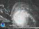
TROPICAL DEPRESSION TWO WAS UPGRADED AT 15/0900 UTC TO TROPICAL
STORM. TROPICAL STORM ANA IS CENTERED NEAR 14.6N 46.8W AT
15/0900 UTC OR ABOUT 1010 MILES EAST OF THE LEEWARD ISLANDS
MOVING W AT 14 KT. ESTIMATED MINIMUM CENTRAL PRESSURE IS 1005
MB. MAXIMUM SUSTAINED WIND SPEED IS 35 KT WITH GUST TO 45 KT.
SEE LATEST NHC FORECAST/ADVISORY UNDER AWIPS/WMO HEADERS
MIATCMAT2/WTNT22 KNHC FOR MORE DETAILS. SCATTERED MODERATE/
ISOLATED STRONG CONVECTION IS WITHIN 90 NM IN THE SW SEMICIRCLE.
$$
WALLACE
AXNT20 KNHC 151144
TWDAT
TROPICAL WEATHER DISCUSSION
NWS TPC/NATIONAL HURRICANE CENTER MIAMI FL
805 AM EDT SAT AUG 15 2009
TROPICAL WEATHER DISCUSSION FOR NORTH AMERICA...CENTRAL
AMERICA...GULF OF MEXICO...CARIBBEAN SEA...NORTHERN SECTIONS
OF SOUTH AMERICA...AND ATLANTIC OCEAN TO THE AFRICAN COAST
FROM THE EQUATOR TO 32N. THE FOLLOWING INFORMATION IS BASED
ON SATELLITE IMAGERY...METEOROLOGICAL ANALYSIS...WEATHER
OBSERVATIONS...AND RADAR.
BASED ON 0600 UTC SURFACE ANALYSIS AND SATELLITE IMAGERY THROUGH
1015 UTC.
...SPECIAL FEATURES...
TROPICAL DEPRESSION TWO WAS UPGRADED AT 15/0900 UTC TO TROPICAL
STORM. TROPICAL STORM ANA IS CENTERED NEAR 14.6N 46.8W AT
15/0900 UTC OR ABOUT 1010 MILES EAST OF THE LEEWARD ISLANDS
MOVING W AT 14 KT. ESTIMATED MINIMUM CENTRAL PRESSURE IS 1005
MB. MAXIMUM SUSTAINED WIND SPEED IS 35 KT WITH GUST TO 45 KT.
SEE LATEST NHC FORECAST/ADVISORY UNDER AWIPS/WMO HEADERS
MIATCMAT2/WTNT22 KNHC FOR MORE DETAILS. SCATTERED MODERATE/
ISOLATED STRONG CONVECTION IS WITHIN 90 NM IN THE SW SEMICIRCLE.
$$
WALLACE
0 likes
-
cyclonic chronic
well how bout this for a morning wake and bake. i was wondering what id be doing today when i went to bed last nite. i know now!!. ill be in front of this compu all day. id say its about time for ana to come along, but not if shes comin here to drop more rain. ive had 3.5" in 3 days with a tropical wave expected today. we've had alot of rain here in s.w. fl the last week, even a tropical storm could pose some flooding probs. IMO. but whatever the case will be im glad to finally get the ball rolling, so to speak. so heres 2 u ANA!

0 likes
-
Blown Away
- S2K Supporter
- Posts: 10253
- Joined: Wed May 26, 2004 6:17 am
Re: ATL : TROPICAL STORM ANA (02L)
Looks like major acceleration on days 4 and 5, hooking a ride on the high pressure!
0 likes
-
Shockwave
- Tropical Storm

- Posts: 167
- Joined: Fri Jul 25, 2008 7:33 am
- Location: Lafayette, TN
- Contact:
Re: ATL : TROPICAL STORM ANA (02L)
One word...FINALLY! ha I am going to have to work on my patience in college as I work towards my meteorology degree.
0 likes
-
Weatherboy1

- Category 5
- Posts: 1190
- Age: 50
- Joined: Mon Jul 05, 2004 1:50 pm
- Location: Jupiter/Sarasota, FL
Well, well, well, this sure is interesting. Had to go to the grocery store anyway today -- might as well beat the crowds! Of course, I just flew back from a weeklong vacation in New Hampshire and on the flight into West Palm, met two nice women who were supposed to spend a week on Grand Bahama Island. Somehow I'm thinking their vacation might not be all it was cracked up to be. Oops!
0 likes
Re: ATL : TROPICAL STORM ANA (02L)
NHC has the max sustained winds at 70 mph when Anna knocks at our door in SE Fla. Can anyone tell us what the different models have the max sustained winds at that point?

0 likes
-
Emmett_Brown

- Category 5
- Posts: 1433
- Joined: Wed Aug 24, 2005 9:10 pm
- Location: Sarasota FL
Re: ATL : TROPICAL STORM ANA (02L)
Thoughts about the track:
1. The models continue to shift W, and have from the beginning. Until this W trend stops, we have to assume that the current Ana track forecast will change, and possible further W and S.
2. Even though there is about 15 degrees longitude of separation between Ana and soon to be TD03/Bill, the mere fact that Ana exists will have some effect on the track of Bill, which means his track is more uncertain. Most models don't show Ana, so their tracks for Bill are probably wrong.
My point:
If you have interests in the islands, Caribbean, or GOM, watch Ana closely.
0 likes
-
BensonTCwatcher

- Category 5
- Posts: 1050
- Joined: Sat Aug 28, 2004 10:11 pm
- Location: Southport NC
Re: ATL : TROPICAL STORM ANA (02L)
Emmett_Brown wrote:Thoughts about the track:
1. The models continue to shift W, and have from the beginning. Until this W trend stops, we have to assume that the current Ana track forecast will change, and possible further W and S.
2. Even though there is about 15 degrees longitude of separation between Ana and soon to be TD03/Bill, the mere fact that Ana exists will have some effect on the track of Bill, which means his track is more uncertain. Most models don't show Ana, so their tracks for Bill are probably wrong.
I agree, I never saw Ana on the global runs yesterday, they are sure to be factored in today. I recall that it's an issue of granularity of the grids for depressions etc. so recon flights and dropsonde data will start to calibrate the models.
0 likes

Re: ATL : TROPICAL STORM ANA (02L)
Special K wrote:NHC has the max sustained winds at 70 mph when Anna knocks at our door in SE Fla. Can anyone tell us what the different models have the max sustained winds at that point?
GFDL 50 mph in GOM (misses S FL)
HWRF CAT 2
SHIPS 65 mph
0 likes
-
wxman57

- Moderator-Pro Met

- Posts: 23168
- Age: 68
- Joined: Sat Jun 21, 2003 8:06 pm
- Location: Houston, TX (southwest)
Re: ATL : TROPICAL STORM ANA (02L)
See what I mean? I had picked August 8th as the date Ana would form back in May. I picked the 8th because I expected it to form on a Saturday (they always do). Today is Saturday and we have Ana. Just a week later. That's why Ana couldn't form before today. It just turned Saturday again. 
0 likes
Who is online
Users browsing this forum: No registered users and 67 guests