ATL: TROPICAL STORM BILL (03L)

Moderator: S2k Moderators

Message
Author
cpdaman
Category 5
Category 5
Posts: 3131
Joined: Sat Jun 10, 2006 11:44 am
Location: SPB county (gulf stream)

Re: ATL: Invest 90L

#341 Postby cpdaman » Thu Aug 13, 2009 9:12 pm

ya are these things supposed to pick up speed ever? later in forecast period?

also anyone have a TCHP map available......those graphs with current temps really don't paint the whole story.......i.e deepness of the warmth......
0 likes   

Derek Ortt

#342 Postby Derek Ortt » Thu Aug 13, 2009 9:20 pm

they typically pick up speed farther west
0 likes   

Aric Dunn
Category 5
Category 5
Posts: 21238
Age: 42
Joined: Sun Sep 19, 2004 9:58 pm
Location: Ready for the Chase.
Contact:

Re: ATL: Invest 90L

#343 Postby Aric Dunn » Thu Aug 13, 2009 9:21 pm

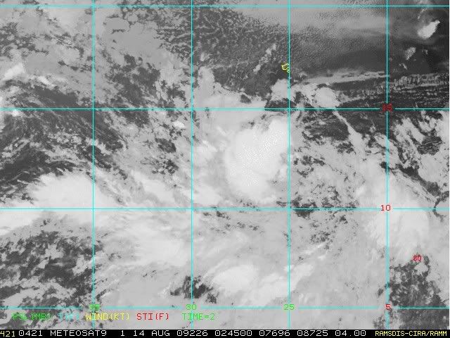
Latest ASCAT over lay showing a broad center still .. but convection is increasing and thats what it needed. It is a large system and they do take time to wrap up.

Image
0 likes   

User avatar
HURAKAN
Professional-Met
Professional-Met
Posts: 46086
Age: 38
Joined: Thu May 20, 2004 4:34 pm
Location: Key West, FL
Contact:

#344 Postby HURAKAN » Thu Aug 13, 2009 9:24 pm

Image

That's right over me but it's quite far into the future
0 likes   

User avatar
wx247
S2K Supporter
S2K Supporter
Posts: 14279
Age: 41
Joined: Wed Feb 05, 2003 10:35 pm
Location: Monett, Missouri
Contact:

#345 Postby wx247 » Thu Aug 13, 2009 9:24 pm

Looks to me as if the convection on the NW side is trying to start wrapping around.
0 likes   

cpdaman
Category 5
Category 5
Posts: 3131
Joined: Sat Jun 10, 2006 11:44 am
Location: SPB county (gulf stream)

Re: ATL: Invest 90L

#346 Postby cpdaman » Thu Aug 13, 2009 9:24 pm

is that giant blob to the far SE even connected to the circulation. it's just bubbling up

also does look like NW side is trying to wrap and the broad center seems to be trying to consolidate
0 likes   

shah8
Category 1
Category 1
Posts: 363
Joined: Wed Aug 30, 2006 4:36 pm

#347 Postby shah8 » Thu Aug 13, 2009 9:25 pm

That's a worse scenario than it looks. Only a 1938 would be worse.
0 likes   

Vandymit
Tropical Low
Tropical Low
Posts: 33
Joined: Wed Aug 11, 2004 12:02 pm

#348 Postby Vandymit » Thu Aug 13, 2009 9:32 pm

What about the shear over this system? 20 kts?
0 likes   

S.FLA STORM TRACKER
Tropical Wave
Tropical Wave
Posts: 8
Age: 67
Joined: Tue Aug 11, 2009 8:10 pm
Location: Westchester / Miami.
Contact:

Re: ATL: Invest 90L

#349 Postby S.FLA STORM TRACKER » Thu Aug 13, 2009 9:40 pm

cpdaman wrote:is that giant blob to the far SE even connected to the circulation. it's just bubbling up

also does look like NW side is trying to wrap and the broad center seems to be trying to consolidate


I was asking about that a bit earlier, bog blow up of storms.
0 likes   

JPmia
S2K Supporter
S2K Supporter
Posts: 1070
Joined: Thu Jun 03, 2004 11:01 pm
Location: Fort Lauderdale, FL

Re:

#350 Postby JPmia » Thu Aug 13, 2009 9:44 pm

HURAKAN wrote:Image

That's right over me but it's quite far into the future


LOL I'm sorry, but that is just ridiculous! Not you Hurakan, the model. It's almost like it is teasing us. New Orleans one night...Miami the other...NYC the next...way too many unknowns regarding trough/ridge setup.
0 likes   

Derek Ortt

#351 Postby Derek Ortt » Thu Aug 13, 2009 9:54 pm

its south of you, Sandy

I wish one of these would just have Miami in the crosshairs. Then we'd probably be safe
0 likes   

JPmia
S2K Supporter
S2K Supporter
Posts: 1070
Joined: Thu Jun 03, 2004 11:01 pm
Location: Fort Lauderdale, FL

Re: ATL: Invest 90L Models

#352 Postby JPmia » Thu Aug 13, 2009 9:55 pm

:uarrow: btw, that run is very close to what Florida's EOC Managers prepare for when planning for the worst case scenario storm hitting the state...Miami to Tampa.
0 likes   

User avatar
SEASON_CANCELED
Category 3
Category 3
Posts: 887
Joined: Mon Jul 06, 2009 5:17 am
Location: 8 Bit Charlie Sheen

Re: ATL: Invest 90L Models

#353 Postby SEASON_CANCELED » Thu Aug 13, 2009 10:03 pm

JPmia wrote::uarrow: btw, that run is very close to what Florida's EOC Managers prepare for when planning for the worst case scenario storm hitting the state...Miami to Tampa.


Tampa when is it there turn? I wonder every year. The effect of a direct hit on Tampa bay/St Pete are would be worse than Katrina. The area is way more built up and entire areas of the city would become islands if a Cat 5 came through. Centcom HQ would be underwater! No way would MacDill surive
0 likes   

User avatar
HURAKAN
Professional-Met
Professional-Met
Posts: 46086
Age: 38
Joined: Thu May 20, 2004 4:34 pm
Location: Key West, FL
Contact:

#354 Postby HURAKAN » Thu Aug 13, 2009 10:06 pm

Image

Looking good. Lets see how it looks tomorrow morning before I leave for Cuba.
0 likes   

rrm
Tropical Depression
Tropical Depression
Posts: 65
Joined: Fri May 15, 2009 2:05 pm

#355 Postby rrm » Thu Aug 13, 2009 10:08 pm

any chance this thing makes it to texas?
0 likes   

User avatar
SEASON_CANCELED
Category 3
Category 3
Posts: 887
Joined: Mon Jul 06, 2009 5:17 am
Location: 8 Bit Charlie Sheen

Re: ATL: Invest 90L

#356 Postby SEASON_CANCELED » Thu Aug 13, 2009 10:09 pm

Definately attempting to close off. upgrade sometime tommorrow.
0 likes   

User avatar
SEASON_CANCELED
Category 3
Category 3
Posts: 887
Joined: Mon Jul 06, 2009 5:17 am
Location: 8 Bit Charlie Sheen

Re:

#357 Postby SEASON_CANCELED » Thu Aug 13, 2009 10:10 pm

rrm wrote:any chance this thing makes it to texas?


Doubt it. But be prepared for anything in the tropics lately. I mean remember humberto.
0 likes   

rrm
Tropical Depression
Tropical Depression
Posts: 65
Joined: Fri May 15, 2009 2:05 pm

#358 Postby rrm » Thu Aug 13, 2009 10:13 pm

yes i do, i was just asking cause i hear about a high pressure ridge building in possibly pushing it west
0 likes   

User avatar
Hurricaneman
Category 5
Category 5
Posts: 7351
Age: 45
Joined: Tue Aug 31, 2004 3:24 pm
Location: central florida

Re: ATL: Invest 90L Models

#359 Postby Hurricaneman » Thu Aug 13, 2009 10:16 pm

imo, the final destination for this will not be found out till some time next week
0 likes   

rrm
Tropical Depression
Tropical Depression
Posts: 65
Joined: Fri May 15, 2009 2:05 pm

#360 Postby rrm » Thu Aug 13, 2009 10:18 pm

does anyone one know about when will we know weather it will make it in the gom or not?
0 likes   


Return to “2009”

Who is online

Users browsing this forum: No registered users and 5 guests