ATL: TROPICAL DEPRESSION ANA (02L)

Moderator: S2k Moderators

Message
Author
tolakram
Admin
Admin
Posts: 20010
Age: 62
Joined: Sun Aug 27, 2006 8:23 pm
Location: Florence, KY (name is Mark)

Re: ATL : TROPICAL DEPRESSION TWO

#861 Postby tolakram » Thu Aug 13, 2009 10:20 am

Image

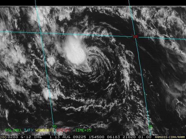
My amateur eyes see TD2 fighting off some of the dry air from earlier, so we'll see what happens. NHC is probably correct.
0 likes   

Air Force Met
Military Met
Military Met
Posts: 4372
Age: 56
Joined: Tue Jul 08, 2003 9:30 am
Location: Roan Mountain, TN

Re: ATL : TROPICAL DEPRESSION TWO

#862 Postby Air Force Met » Thu Aug 13, 2009 10:33 am

wxman57 wrote:Just a lone thunderstorm near the remnant low. Little inflow now, just a residual swirl. I like the new NHC forecast of 25kts through 120hrs. This one won't be Ana.


I agree. 90L will keep this from being Ana...along with a bunch of other factors.
0 likes   

User avatar
HURAKAN
Professional-Met
Professional-Met
Posts: 46086
Age: 38
Joined: Thu May 20, 2004 4:34 pm
Location: Key West, FL
Contact:

#863 Postby HURAKAN » Thu Aug 13, 2009 10:59 am

Image

Convection trying to make a comeback
0 likes   

User avatar
BensonTCwatcher
Category 5
Category 5
Posts: 1046
Joined: Sat Aug 28, 2004 10:11 pm
Location: Southport NC

Re: ATL : TROPICAL DEPRESSION TWO

#864 Postby BensonTCwatcher » Thu Aug 13, 2009 11:05 am

I agree no Ana from this system. I don't think we should be calling "sick bay" just yet to have Bones come out and make and pronoucements yet. The circulation is alive and well and until poof-a-genesis in underway this could be named something else. We have watched a few naked swirls come back from the dead. We don't want a zombie storm later. It interesting when that happens though what to names et al.
0 likes   

User avatar
cycloneye
Admin
Admin
Posts: 145366
Age: 68
Joined: Thu Oct 10, 2002 10:54 am
Location: San Juan, Puerto Rico

Re: ATL : TROPICAL DEPRESSION TWO

#865 Postby cycloneye » Thu Aug 13, 2009 11:05 am

Easterly shear still is impacting it.
0 likes   

User avatar
KWT
Category 5
Category 5
Posts: 31415
Joined: Tue Aug 17, 2004 11:02 am
Location: UK!!!

#866 Postby KWT » Thu Aug 13, 2009 11:07 am

Yep convection is still trying to stick with the circulation, not a great looking system mind you!
0 likes   

User avatar
HURAKAN
Professional-Met
Professional-Met
Posts: 46086
Age: 38
Joined: Thu May 20, 2004 4:34 pm
Location: Key West, FL
Contact:

#867 Postby HURAKAN » Thu Aug 13, 2009 11:07 am

Image

Doria in 1971 spent many days as a tropical depression before getting named. I'm going 50/50 with TD 2. It could likely die as it could continue living in the border between TD and remnant low.
0 likes   

User avatar
HURAKAN
Professional-Met
Professional-Met
Posts: 46086
Age: 38
Joined: Thu May 20, 2004 4:34 pm
Location: Key West, FL
Contact:

Re: ATL : TROPICAL DEPRESSION TWO

#868 Postby HURAKAN » Thu Aug 13, 2009 11:19 am

Jeff Masters: http://www.wunderground.com/blog/JeffMa ... rynum=1278

Tropical Depression Two is near death, but is still worth watching. The dry, Saharan air to the north and west of the depression, combined with moderately high levels of wind shear of 15 - 20 knots, have almost completely destroyed all of TD 2's heavy thunderstorms. Satellite loops of the storm show a well-formed circulation, but almost no heavy thunderstorm activity.

Wind shear over TD 2 is expected to remain in the modereate range, 10 - 20 knots, over the next five days. Sea Surface Temperatures (SSTs) are 27°C, but will warm to 28°C three days from now. There is plenty of dry, stable air from the Saharan Air Layer (SAL) to to TD 2's north and west that will continue to cause the storm problems. The relatively cool SSTs and dry air mean that TD 2 will not be able to intensify quickly, and some of the models indicate the TD 2 may get destroyed in the next day or two. However, several models still predict TD 2 will become a tropical storm. The HWRF model predicts TD 2 will become a hurricane five days from now, but this seems unlikely given the dry air and relatively high wind shear affecting the storm.
0 likes   

CrazyC83
Professional-Met
Professional-Met
Posts: 34002
Joined: Tue Mar 07, 2006 11:57 pm
Location: Deep South, for the first time!

#869 Postby CrazyC83 » Thu Aug 13, 2009 11:23 am

This system has fooled us so many times that all we can do is roll dice now...it looked dead, then became a TD, then looked dead, then almost became a TS then looked as good as dead again...
0 likes   

User avatar
srainhoutx
S2K Supporter
S2K Supporter
Posts: 6919
Age: 67
Joined: Sun Jan 14, 2007 11:34 am
Location: Haywood County, NC
Contact:

Re: ATL : TROPICAL DEPRESSION TWO

#870 Postby srainhoutx » Thu Aug 13, 2009 12:23 pm

Image
0 likes   

User avatar
HURAKAN
Professional-Met
Professional-Met
Posts: 46086
Age: 38
Joined: Thu May 20, 2004 4:34 pm
Location: Key West, FL
Contact:

#871 Postby HURAKAN » Thu Aug 13, 2009 12:28 pm

646
WHXX04 KWBC 131717
CHGQLM
ATTENTION...NATIONAL HURRICANE CENTER

NCEP COUPLED GFDL HURRICANE MODEL FORECAST MADE FOR

TROPICAL DEPRESSION TWO 02L

INITIAL TIME 12Z AUG 13

DISCLAIMER ... THIS INFORMATION IS PROVIDED AS GUIDANCE. IT
REQUIRES INTERPRETATION BY HURRICANE SPECIALISTS AND SHOULD
NOT BE CONSIDERED AS A FINAL PRODUCT. PLEASE SEE THE TPC/NHC
OFFICIAL FORECAST.


FORECAST STORM POSITION

HOUR LATITUDE LONGITUDE HEADING/SPEED(KT)

0 13.7 37.0 265./ 8.0
6 14.3 37.7 310./ 9.3
12 14.6 39.0 281./12.6
18 14.7 40.0 278./10.1
24 15.1 41.7 283./17.0
30 15.2 43.2 271./14.1
36 15.5 44.7 282./14.3
42 15.5 46.5 271./17.5
48 15.6 48.1 273./15.4
54 15.7 49.8 275./16.7
60 15.8 51.5 274./16.7
66 16.0 53.5 275./18.6
72 16.5 55.4 285./19.1
78 16.8 57.4 277./19.3
84 17.1 59.2 280./18.2
90 17.6 61.6 281./22.6
96 18.2 63.3 291./18.2
102 18.9 65.4 287./20.7
108 19.4 67.4 285./19.3
114 20.1 69.2 291./18.3
120 20.9 70.8 298./16.8
126 22.1 72.3 307./18.0

0 likes   

User avatar
Blown Away
S2K Supporter
S2K Supporter
Posts: 10147
Joined: Wed May 26, 2004 6:17 am

Re: ATL: TROPICAL DEPRESSION TWO (Models)

#872 Postby Blown Away » Thu Aug 13, 2009 12:32 pm

:uarrow:
Notice the increased forward speed at the end GFDL run, maybe it has hooked a ride along the bottom of the BH sending it W.
0 likes   

User avatar
HURAKAN
Professional-Met
Professional-Met
Posts: 46086
Age: 38
Joined: Thu May 20, 2004 4:34 pm
Location: Key West, FL
Contact:

#873 Postby HURAKAN » Thu Aug 13, 2009 12:34 pm

Image

Old burst weakens, new develops.
0 likes   

CrazyC83
Professional-Met
Professional-Met
Posts: 34002
Joined: Tue Mar 07, 2006 11:57 pm
Location: Deep South, for the first time!

#874 Postby CrazyC83 » Thu Aug 13, 2009 12:40 pm

At least with these bursts of convection it is still a TD, albeit a crap one...
0 likes   

User avatar
wxman57
Moderator-Pro Met
Moderator-Pro Met
Posts: 22979
Age: 67
Joined: Sat Jun 21, 2003 8:06 pm
Location: Houston, TX (southwest)

Re: ATL : TROPICAL DEPRESSION TWO

#875 Postby wxman57 » Thu Aug 13, 2009 12:46 pm

That small storm NW of the center is now weakening and moving off to the west, leaving a weakening low-level swirl. I think the NHC may kill it on the next advisory.
0 likes   

User avatar
HouTXmetro
Category 5
Category 5
Posts: 3949
Joined: Sun Jun 13, 2004 6:00 pm
Location: District of Columbia, USA

Re: ATL : TROPICAL DEPRESSION TWO

#876 Postby HouTXmetro » Thu Aug 13, 2009 1:29 pm

I feel like I'm watching the Animal planet and TD2 is prey trying to escape 90L. Run! but he just can escape.
0 likes   

User avatar
ROCK
Category 5
Category 5
Posts: 9484
Age: 54
Joined: Tue Aug 17, 2004 7:30 am
Location: Kemah, Texas

Re: ATL : TROPICAL DEPRESSION TWO

#877 Postby ROCK » Thu Aug 13, 2009 1:55 pm

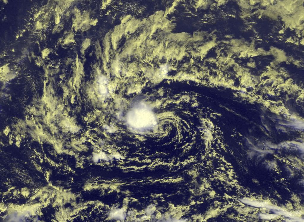
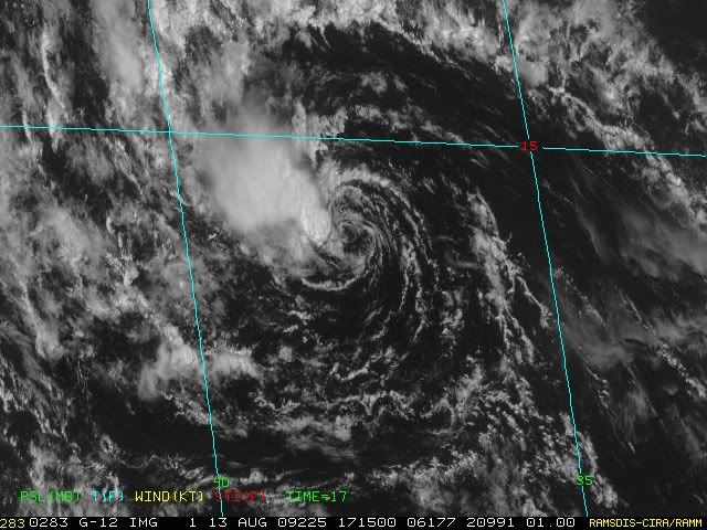
wxman57 wrote:That small storm NW of the center is now weakening and moving off to the west, leaving a weakening low-level swirl. I think the NHC may kill it on the next advisory.


we are all waiting!!! for you know who....
0 likes   

User avatar
Evil Jeremy
S2K Supporter
S2K Supporter
Posts: 5463
Age: 32
Joined: Mon Apr 10, 2006 2:10 pm
Location: Los Angeles, CA

#878 Postby Evil Jeremy » Thu Aug 13, 2009 2:10 pm

If these new bursts of convection can hang on until the next D-Max, TD2 might survive. Granted the odds are against it, but anything can happen in the tropics. As for the kill switch, I think the NHC will keep TD2 alive at the 5 PM advisory to see what happens with the convection flaring up right now.
0 likes   

Brent
S2K Supporter
S2K Supporter
Posts: 38091
Age: 36
Joined: Sun May 16, 2004 10:30 pm
Location: Tulsa Oklahoma
Contact:

Re: ATL : TROPICAL DEPRESSION TWO

#879 Postby Brent » Thu Aug 13, 2009 3:41 pm

THIS IS THE LAST FORECAST/ADVISORY ISSUED BY THE
NATIONAL HURRICANE CENTER ON THIS SYSTEM. THIS SYSTEM WILL BE
CLOSELY MONITORED FOR SIGNS OF REGENERATION.
0 likes   

User avatar
cycloneye
Admin
Admin
Posts: 145366
Age: 68
Joined: Thu Oct 10, 2002 10:54 am
Location: San Juan, Puerto Rico

Re: ATL : TROPICAL DEPRESSION TWO (Advisories)

#880 Postby cycloneye » Thu Aug 13, 2009 3:42 pm

Last Advisory

498
WTNT32 KNHC 132041
TCPAT2
BULLETIN
TROPICAL DEPRESSION TWO ADVISORY NUMBER 11
NWS TPC/NATIONAL HURRICANE CENTER MIAMI FL AL022009
500 PM AST THU AUG 13 2009

...DEPRESSION HAS DECAYED INTO A REMNANT LOW PRESSURE AREA...

AT 500 PM AST...2100 UTC...THE CENTER OF THE REMNANTS OF TROPICAL
DEPRESSION TWO WAS LOCATED NEAR LATITUDE 14.2 NORTH...LONGITUDE
38.3 WEST OR ABOUT 930 MILES...1500 KM...WEST OF THE SOUTHERNMOST
CAPE VERDE ISLANDS.

THE LOW IS MOVING TOWARD THE WEST NEAR 8 MPH...13 KM/HR. THE
REMNANTS OF THE DEPRESSION ARE EXPECTED TO CONTINUE A GENERAL
WESTWARD MOTION FOR THE NEXT COUPLE OF DAYS.

MAXIMUM SUSTAINED WINDS ARE NEAR 30 MPH...45 KM/HR...WITH HIGHER
GUSTS. THE REMNANTS ARE EXPECTED TO CHANGE LITTLE IN STRENGTH OVER
THE NEXT COUPLE OF DAYS.

ESTIMATED MINIMUM CENTRAL PRESSURE IS 1008 MB...29.77 INCHES.

...SUMMARY OF 500 PM AST INFORMATION...
LOCATION...14.2N 38.3W
MAXIMUM SUSTAINED WINDS...30 MPH
PRESENT MOVEMENT...WEST OR 275 DEGREES AT 8 MPH
MINIMUM CENTRAL PRESSURE...1008 MB

THIS IS THE LAST PUBLIC ADVISORY ISSUED BY THE NATIONAL HURRICANE
CENTER ON THIS SYSTEM. THE SYSTEM WILL BE CLOSELY MONITORED FOR
SIGNS OF REGENERATION. ADDITIONAL INFORMATION ON THIS SYSTEM CAN BE
FOUND IN HIGH SEAS FORECASTS ISSUED BY THE NATIONAL WEATHER
SERVICE...UNDER AWIPS HEADER NFDHSFAT1 AND WMO HEADER FZNT01 KWBC.

$$
FORECASTER BEVEN

WTNT42 KNHC 132041
TCDAT2
TROPICAL DEPRESSION TWO DISCUSSION NUMBER 11
NWS TPC/NATIONAL HURRICANE CENTER MIAMI FL AL022009
500 PM AST THU AUG 13 2009

WHILE PERSISTING OVER THE PAST SEVERAL HOURS...THE AREA OF
CONVECTION JUST WEST OF THE CENTER OF TROPICAL DEPRESSION TWO IS
TOO SMALL TO BE CLASSIFIED USING THE DVORAK TECHNIQUE. INDEED...IT
HAS BEEN ALMOST 24 HR SINCE ENOUGH ORGANIZED CONVECTION EXISTED TO
GET A DATA-T NUMBER. BASED ON THIS...THE DEPRESSION HAS DECAYED
INTO A REMNANT LOW PRESSURE AREA. IT IS LIKELY THAT THE SYSTEM
WILL CONTINUE TO PRODUCE BURSTS OF CONVECTION FOR THE NEXT SEVERAL
DAYS...AND A FASTER FORWARD MOTION IS EXPECTED BY THE END OF THE
FORECAST PERIOD. THIS IS THE BASIS FOR KEEPING A 25 KT INTENSITY
FOR THE REMNANTS THROUGH 120 HR. SEVERAL OF THE INTENSITY FORECAST
MODELS CONTINUE TO FORECAST STRENGTHENING...SO IF THE SYSTEM FINDS
A MORE FAVORABLE ENVIRONMENT IT COULD REGENERATE.

THE INITIAL MOTION IS 275/8. THERE IS LITTLE CHANGE TO THE
FORECAST PHILOSOPHY FROM THE PREVIOUS FORECAST. THE SYSTEM IS
ON THE SOUTH SIDE OF A LOW/MID-LEVEL RIDGE...WHICH SHOULD RESULT IN
A WESTWARD MOTION FOR THE NEXT COUPLE OF DAYS. AFTER THAT...IT
SHOULD GRADUALLY TURN WEST-NORTHWESTWARD TOWARD A WEAKNESS IN THE
RIDGE OVER THE WESTERN ATLANTIC. THE NEW FORECAST TRACK IS
BASICALLY AN UPDATE OF THE PREVIOUS ADVISORY. IT SHOULD BE NOTED
THAT SEVERAL GLOBAL MODELS SHOW THE REMNANT LOW WEAKENING TO A
TROPICAL WAVE...AND IF THIS OCCURS THE SYSTEM COULD MOVE FARTHER
SOUTH THAN CURRENTLY FORECAST.

FORECAST POSITIONS AND MAX WINDS

INITIAL 13/2100Z 14.2N 38.3W 25 KT...REMNANT LOW
12HR VT 14/0600Z 14.3N 39.7W 25 KT...REMNANT LOW
24HR VT 14/1800Z 14.5N 42.2W 25 KT...REMNANT LOW
36HR VT 15/0600Z 14.8N 44.8W 25 KT...REMNANT LOW
48HR VT 15/1800Z 15.1N 47.7W 25 KT...REMNANT LOW
72HR VT 16/1800Z 16.5N 54.0W 25 KT...REMNANT LOW
96HR VT 17/1800Z 19.0N 61.0W 25 KT...REMNANT LOW
120HR VT 18/1800Z 23.0N 67.5W 25 KT...REMNANT LOW

$$
FORECASTER BEVEN


0 likes   


Return to “2009”

Who is online

Users browsing this forum: No registered users and 8 guests