ATL: TROPICAL DEPRESSION ANA (02L)
Moderator: S2k Moderators
-
wxman57

- Moderator-Pro Met

- Posts: 23172
- Age: 68
- Joined: Sat Jun 21, 2003 8:06 pm
- Location: Houston, TX (southwest)
Re: ATL : TROPICAL DEPRESSION TWO
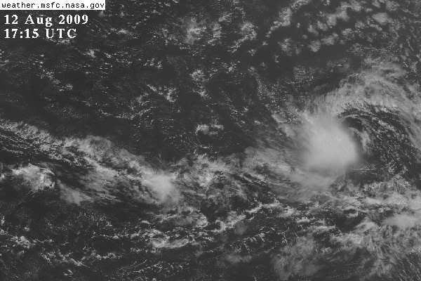
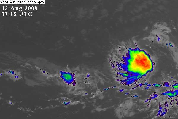
Big image (above). We estimate that current shear across TD 2 is about 30-35 kts out of the ENE-E. I see that the disturbance to the east is now a "medium" threat for development - though no invest yet.
0 likes
Re: ATL : TROPICAL DEPRESSION TWO
wxman57 wrote:Big image (above). We estimate that current shear across TD 2 is about 30-35 kts out of the ENE-E. I see that the disturbance to the east is now a "medium" threat for development - though no invest yet.
They will probably tag it at the 18z atcf update.
0 likes
-
Aric Dunn
- Category 5

- Posts: 21238
- Age: 43
- Joined: Sun Sep 19, 2004 9:58 pm
- Location: Ready for the Chase.
- Contact:
Re: ATL : TROPICAL DEPRESSION TWO
wxman57 wrote:Big image (above). We estimate that current shear across TD 2 is about 30-35 kts out of the ENE-E. I see that the disturbance to the east is now a "medium" threat for development - though no invest yet.
yeah i just got done looking at the wave east of there .. very impressive an very low latitude...
0 likes


-
tolakram
- Admin

- Posts: 20179
- Age: 62
- Joined: Sun Aug 27, 2006 8:23 pm
- Location: Florence, KY (name is Mark)
Re: ATL : TROPICAL DEPRESSION TWO
Making a guess here:
http://www.ssd.noaa.gov/goes/flt/t1/flash-avn.html
From the looks of it convection has ceased (or diminished) and the high clouds are blowing away to the southwest.
http://www.ssd.noaa.gov/goes/flt/t1/flash-avn.html
From the looks of it convection has ceased (or diminished) and the high clouds are blowing away to the southwest.
0 likes
-
PTrackerLA

- Category 5
- Posts: 5281
- Age: 42
- Joined: Thu Oct 10, 2002 8:40 pm
- Location: Lafayette, LA
Re: ATL : TROPICAL DEPRESSION TWO
Just name the darn thing NHC, like yall have said I've seen completely exposed circulation centers get upgraded to tropical storm status. Plus in my mind future 90L is already Bill so it will make things easier  .
.
0 likes

Re: ATL : TROPICAL DEPRESSION TWO
tolakram wrote:Making a guess here:
http://www.ssd.noaa.gov/goes/flt/t1/flash-avn.html
From the looks of it convection has ceased (or diminished) and the high clouds are blowing away to the southwest.
Overall, it does look like the convective and cloud pattern has degraded since this morning.
0 likes

first time posting here - and a complete newcomer/ amatuer to the subject ...
The clip here ( http://rammb.cira.colostate.edu/ramsdis ... is_floater) shows some form of mushrooming or similar in the clouds around the center. Does this have any significance or is it 'normal' behaviour?
Thanks
The clip here ( http://rammb.cira.colostate.edu/ramsdis ... is_floater) shows some form of mushrooming or similar in the clouds around the center. Does this have any significance or is it 'normal' behaviour?
Thanks
0 likes

Re: ATL : TROPICAL DEPRESSION TWO
Ana at 5pm perhaps? 
It's true though.. worse looking systems have been upgraded.
It's true though.. worse looking systems have been upgraded.
0 likes
-
dolebot_Broward_NW
- Category 2

- Posts: 529
- Joined: Fri Sep 10, 2004 6:38 am
Re: ATL : TROPICAL DEPRESSION TWO
Hi Shaun,
Welcome to storm2k!
The mushrooming that you see is a result of the sun going down. Most disturbances, and certainly all systems with organized convection, have a "3d" or vertical element. Most sat pics, radar, etc are represented in a 2d fashion, in sat pics like this, they are usually like a photograph from afar. Any vertical element would come AT the viewer, thus being a bit hard to visualize.
Now at this time of day, the sun is setting over the disturbance. This means the suns rays are coming at an angle, vs - straight down (as at noon). This enhances the "vertical visibility" and is usually a daily event. Just like at dusk/dawn where you live, the clouds look different at that time of day.
Also the satellite taking this photo happens to be a good bit further to the west in a geosynchronous orbit (that means its position doesn't change). It needs to look a bit to the right to see the system.
Combine the two of them and you have a nice sunset shot that while it did have that mushroom effect, since the sun wasn't at an angle, it was much harder to notice.
0 likes
-
HURAKAN

- Professional-Met

- Posts: 46084
- Age: 39
- Joined: Thu May 20, 2004 4:34 pm
- Location: Key West, FL
- Contact:
Re: ATL : TROPICAL DEPRESSION TWO
Shaun2453 wrote:Many thanks
Welcome to S2k. You're just in time for the best part of the year!
Shear, shear, shear. Nothing new in 2009!
0 likes
-
thetruesms

- Professional-Met
- Posts: 844
- Age: 42
- Joined: Thu Aug 16, 2007 1:14 pm
- Location: Tallahasee, FL
- Contact:
Re: ATL : TROPICAL DEPRESSION TWO
It's quite dramatic how everything's getting sheared away in that loopHURAKAN wrote:Shaun2453 wrote:Many thanks
Welcome to S2k. You're just in time for the best part of the year!
[img]http://i40.photobucket.com/albums/e244/zdtadmin/at200902_sat_2_anim.gif[img]
Shear, shear, shear. Nothing new in 2009!
0 likes
-
HURAKAN
- Professional-Met
- Posts: 46084
- Age: 39
- Joined: Thu May 20, 2004 4:34 pm
- Location: Key West, FL
- Contact:
931
WHXX01 KWBC 121853
CHGHUR
TROPICAL CYCLONE GUIDANCE MESSAGE
NWS TPC/NATIONAL HURRICANE CENTER MIAMI FL
1853 UTC WED AUG 12 2009
DISCLAIMER...NUMERICAL MODELS ARE SUBJECT TO LARGE ERRORS.
PLEASE REFER TO NHC OFFICIAL FORECASTS FOR TROPICAL CYCLONE
AND SUBTROPICAL CYCLONE INFORMATION.
ATLANTIC OBJECTIVE AIDS FOR
TROPICAL CYCLONE TWO (AL022009) 20090812 1800 UTC
...00 HRS... ...12 HRS... ...24 HRS. .. ...36 HRS...
090812 1800 090813 0600 090813 1800 090814 0600
LAT LON LAT LON LAT LON LAT LON
BAMS 14.3N 34.4W 14.4N 36.3W 14.7N 38.3W 15.0N 40.4W
BAMD 14.3N 34.4W 14.4N 36.7W 14.9N 39.2W 15.6N 41.4W
BAMM 14.3N 34.4W 14.4N 36.3W 14.9N 38.3W 15.3N 40.3W
LBAR 14.3N 34.4W 14.3N 36.8W 14.8N 39.6W 15.6N 42.5W
SHIP 35KTS 40KTS 45KTS 49KTS
DSHP 35KTS 40KTS 45KTS 49KTS
...48 HRS... ...72 HRS... ...96 HRS. .. ..120 HRS...
090814 1800 090815 1800 090816 1800 090817 1800
LAT LON LAT LON LAT LON LAT LON
BAMS 15.4N 42.8W 16.9N 49.6W 20.0N 58.4W 23.7N 66.5W
BAMD 16.4N 43.8W 18.5N 48.9W 21.1N 54.6W 24.4N 59.3W
BAMM 15.8N 42.6W 17.3N 48.6W 19.6N 56.7W 23.2N 64.3W
LBAR 16.5N 45.4W 19.0N 51.1W 21.7N 56.8W .0N .0W
SHIP 52KTS 57KTS 53KTS 49KTS
DSHP 52KTS 57KTS 53KTS 49KTS
...INITIAL CONDITIONS...
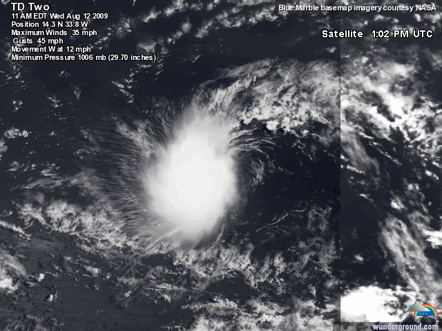
LATCUR = 14.3N LONCUR = 34.4W DIRCUR = 265DEG SPDCUR = 12KT
LATM12 = 14.6N LONM12 = 32.0W DIRM12 = 265DEG SPDM12 = 11KT
LATM24 = 14.6N LONM24 = 29.9W
WNDCUR = 35KT RMAXWD = 50NM WNDM12 = 30KT
CENPRS = 1005MB OUTPRS = 1012MB OUTRAD = 150NM SDEPTH = M
RD34NE = 0NM RD34SE = 0NM RD34SW = 0NM RD34NW = 50NM
$$
NNNN
WHXX01 KWBC 121853
CHGHUR
TROPICAL CYCLONE GUIDANCE MESSAGE
NWS TPC/NATIONAL HURRICANE CENTER MIAMI FL
1853 UTC WED AUG 12 2009
DISCLAIMER...NUMERICAL MODELS ARE SUBJECT TO LARGE ERRORS.
PLEASE REFER TO NHC OFFICIAL FORECASTS FOR TROPICAL CYCLONE
AND SUBTROPICAL CYCLONE INFORMATION.
ATLANTIC OBJECTIVE AIDS FOR
TROPICAL CYCLONE TWO (AL022009) 20090812 1800 UTC
...00 HRS... ...12 HRS... ...24 HRS. .. ...36 HRS...
090812 1800 090813 0600 090813 1800 090814 0600
LAT LON LAT LON LAT LON LAT LON
BAMS 14.3N 34.4W 14.4N 36.3W 14.7N 38.3W 15.0N 40.4W
BAMD 14.3N 34.4W 14.4N 36.7W 14.9N 39.2W 15.6N 41.4W
BAMM 14.3N 34.4W 14.4N 36.3W 14.9N 38.3W 15.3N 40.3W
LBAR 14.3N 34.4W 14.3N 36.8W 14.8N 39.6W 15.6N 42.5W
SHIP 35KTS 40KTS 45KTS 49KTS
DSHP 35KTS 40KTS 45KTS 49KTS
...48 HRS... ...72 HRS... ...96 HRS. .. ..120 HRS...
090814 1800 090815 1800 090816 1800 090817 1800
LAT LON LAT LON LAT LON LAT LON
BAMS 15.4N 42.8W 16.9N 49.6W 20.0N 58.4W 23.7N 66.5W
BAMD 16.4N 43.8W 18.5N 48.9W 21.1N 54.6W 24.4N 59.3W
BAMM 15.8N 42.6W 17.3N 48.6W 19.6N 56.7W 23.2N 64.3W
LBAR 16.5N 45.4W 19.0N 51.1W 21.7N 56.8W .0N .0W
SHIP 52KTS 57KTS 53KTS 49KTS
DSHP 52KTS 57KTS 53KTS 49KTS
...INITIAL CONDITIONS...
LATCUR = 14.3N LONCUR = 34.4W DIRCUR = 265DEG SPDCUR = 12KT
LATM12 = 14.6N LONM12 = 32.0W DIRM12 = 265DEG SPDM12 = 11KT
LATM24 = 14.6N LONM24 = 29.9W
WNDCUR = 35KT RMAXWD = 50NM WNDM12 = 30KT
CENPRS = 1005MB OUTPRS = 1012MB OUTRAD = 150NM SDEPTH = M
RD34NE = 0NM RD34SE = 0NM RD34SW = 0NM RD34NW = 50NM
$$
NNNN
0 likes
-
HURAKAN
- Professional-Met
- Posts: 46084
- Age: 39
- Joined: Thu May 20, 2004 4:34 pm
- Location: Key West, FL
- Contact:
931
WHXX01 KWBC 121853
CHGHUR
TROPICAL CYCLONE GUIDANCE MESSAGE
NWS TPC/NATIONAL HURRICANE CENTER MIAMI FL
1853 UTC WED AUG 12 2009
DISCLAIMER...NUMERICAL MODELS ARE SUBJECT TO LARGE ERRORS.
PLEASE REFER TO NHC OFFICIAL FORECASTS FOR TROPICAL CYCLONE
AND SUBTROPICAL CYCLONE INFORMATION.
ATLANTIC OBJECTIVE AIDS FOR
TROPICAL CYCLONE TWO (AL022009) 20090812 1800 UTC
...00 HRS... ...12 HRS... ...24 HRS. .. ...36 HRS...
090812 1800 090813 0600 090813 1800 090814 0600
LAT LON LAT LON LAT LON LAT LON
BAMS 14.3N 34.4W 14.4N 36.3W 14.7N 38.3W 15.0N 40.4W
BAMD 14.3N 34.4W 14.4N 36.7W 14.9N 39.2W 15.6N 41.4W
BAMM 14.3N 34.4W 14.4N 36.3W 14.9N 38.3W 15.3N 40.3W
LBAR 14.3N 34.4W 14.3N 36.8W 14.8N 39.6W 15.6N 42.5W
SHIP 35KTS 40KTS 45KTS 49KTS
DSHP 35KTS 40KTS 45KTS 49KTS
...48 HRS... ...72 HRS... ...96 HRS. .. ..120 HRS...
090814 1800 090815 1800 090816 1800 090817 1800
LAT LON LAT LON LAT LON LAT LON
BAMS 15.4N 42.8W 16.9N 49.6W 20.0N 58.4W 23.7N 66.5W
BAMD 16.4N 43.8W 18.5N 48.9W 21.1N 54.6W 24.4N 59.3W
BAMM 15.8N 42.6W 17.3N 48.6W 19.6N 56.7W 23.2N 64.3W
LBAR 16.5N 45.4W 19.0N 51.1W 21.7N 56.8W .0N .0W
SHIP 52KTS 57KTS 53KTS 49KTS
DSHP 52KTS 57KTS 53KTS 49KTS
...INITIAL CONDITIONS...
LATCUR = 14.3N LONCUR = 34.4W DIRCUR = 265DEG SPDCUR = 12KT
LATM12 = 14.6N LONM12 = 32.0W DIRM12 = 265DEG SPDM12 = 11KT
LATM24 = 14.6N LONM24 = 29.9W
WNDCUR = 35KT RMAXWD = 50NM WNDM12 = 30KT
CENPRS = 1005MB OUTPRS = 1012MB OUTRAD = 150NM SDEPTH = M
RD34NE = 0NM RD34SE = 0NM RD34SW = 0NM RD34NW = 50NM
$$
NNNN
0 likes
Who is online
Users browsing this forum: No registered users and 11 guests