ATTM the disturbance you mentioned has dropped SW into the ITCZ, so nothing to talk about for now, since the models will pick up on anythng at this time of year and send it westward...
http://www.ssd.noaa.gov/eumet/eatl/loop-avn.html
Frank
ATL: TROPICAL DEPRESSION ANA (02L)
Moderator: S2k Moderators
-
Ed Mahmoud
Re: ATL : TROPICAL DEPRESSION TWO
Refreshed loop, and barfed out outflow boundary starting to get caught up in circulation of TD #2 and rotate back in, so maybe TD #02L is healthier than I have ot credit for.
0 likes
-
wxman57

- Moderator-Pro Met

- Posts: 23172
- Age: 68
- Joined: Sat Jun 21, 2003 8:06 pm
- Location: Houston, TX (southwest)
Re: ATL : TROPICAL DEPRESSION TWO
Evil Jeremy wrote:
Also, I read through the NHC's discussion for advisory 1 and found it funny that they were saying that the more north the storm goes, the weaker it will be, and the more south it stays, the stronger it can become. Normally its the stronger the storm would be, the more it would be effected by the weaknesses to the north so it will move more north. Just found that funny.
The NHC isn't determining motion based on intensity, they're saying that if the system tracks farther north it will be moving over cooler water - thus less strengthening. If it tracks farther west (doesn't gain much latitude), it will be over warmer water and able to become stronger.
0 likes
-
hurricanefloyd5

- Category 5

- Posts: 1659
- Age: 45
- Joined: Sun May 02, 2004 10:53 am
- Location: Spartanburg
- Contact:
Re: ATL : TROPICAL DEPRESSION TWO
this TD I would guess that it will push alot farther west then what EVERYONE thinks and this is the first set of model runs!!!!
0 likes
-
vbhoutex
- Storm2k Executive

- Posts: 29146
- Age: 74
- Joined: Wed Oct 09, 2002 11:31 pm
- Location: Cypress, TX
- Contact:
Re: ATL : TROPICAL DEPRESSION TWO
hurricanefloyd5 wrote:this TD I would guess that it will push alot farther west then what EVERYONE thinks and this is the first set of model runs!!!!
Easy to say. Now tell us why you think that. What is the reasoning?
0 likes
-
srainhoutx

- S2K Supporter

- Posts: 6919
- Age: 68
- Joined: Sun Jan 14, 2007 11:34 am
- Location: Haywood County, NC
- Contact:
-
Evil Jeremy

- S2K Supporter
- Posts: 5463
- Age: 32
- Joined: Mon Apr 10, 2006 2:10 pm
- Location: Los Angeles, CA
Re: ATL : TROPICAL DEPRESSION TWO
wxman57 wrote:Evil Jeremy wrote:
Also, I read through the NHC's discussion for advisory 1 and found it funny that they were saying that the more north the storm goes, the weaker it will be, and the more south it stays, the stronger it can become. Normally its the stronger the storm would be, the more it would be effected by the weaknesses to the north so it will move more north. Just found that funny.
The NHC isn't determining motion based on intensity, they're saying that if the system tracks farther north it will be moving over cooler water - thus less strengthening. If it tracks farther west (doesn't gain much latitude), it will be over warmer water and able to become stronger.
I know that, I am just saying it is the opposite of what normally happen, and it is happening for different reasons. Also, if the storm moves north, not only will it encounter cooler waters, it will be under more shear.
0 likes
-
HURAKAN

- Professional-Met

- Posts: 46084
- Age: 39
- Joined: Thu May 20, 2004 4:34 pm
- Location: Key West, FL
- Contact:
635
WTNT32 KNHC 111445
TCPAT2
BULLETIN
TROPICAL DEPRESSION TWO ADVISORY NUMBER 2
NWS TPC/NATIONAL HURRICANE CENTER MIAMI FL AL022009
1100 AM AST TUE AUG 11 2009
...DEPRESSION MOVING WESTWARD...NO CHANGE IN INTENSITY...
AT 1100 AM AST...1500 UTC...THE CENTER OF TROPICAL DEPRESSION TWO
WAS LOCATED NEAR LATITUDE 14.6 NORTH...LONGITUDE 29.6 WEST OR ABOUT
350 MILES...560 KM...WEST OF THE SOUTHERNMOST CAPE VERDE ISLANDS.
THE DEPRESSION IS MOVING TOWARD THE WEST NEAR 13 MPH...20 KM/HR...
AND THIS GENERAL MOTION IS EXPECTED TO CONTINUE OVER THE NEXT
COUPLE OF DAYS.
MAXIMUM SUSTAINED WINDS ARE NEAR 30 MPH...45 KM/HR...WITH HIGHER
GUSTS. SOME SLOW STRENGTHENING IS FORECAST DURING THE NEXT 24
HOURS...AND THE DEPRESSION COULD BECOME A TROPICAL STORM IN A DAY
OR TWO.
ESTIMATED MINIMUM CENTRAL PRESSURE IS 1006 MB...29.71 INCHES.
...SUMMARY OF 1100 AM AST INFORMATION...
LOCATION...14.6N 29.6W
MAXIMUM SUSTAINED WINDS...30 MPH
PRESENT MOVEMENT...WEST OR 275 DEGREES AT 13 MPH
MINIMUM CENTRAL PRESSURE...1006 MB
THE NEXT ADVISORY WILL BE ISSUED BY THE NATIONAL HURRICANE CENTER AT
500 PM AST.
$$
FORECASTER BERG
949
WTNT42 KNHC 111445
TCDAT2
TROPICAL DEPRESSION TWO DISCUSSION NUMBER 2
NWS TPC/NATIONAL HURRICANE CENTER MIAMI FL AL022009
1100 AM AST TUE AUG 11 2009
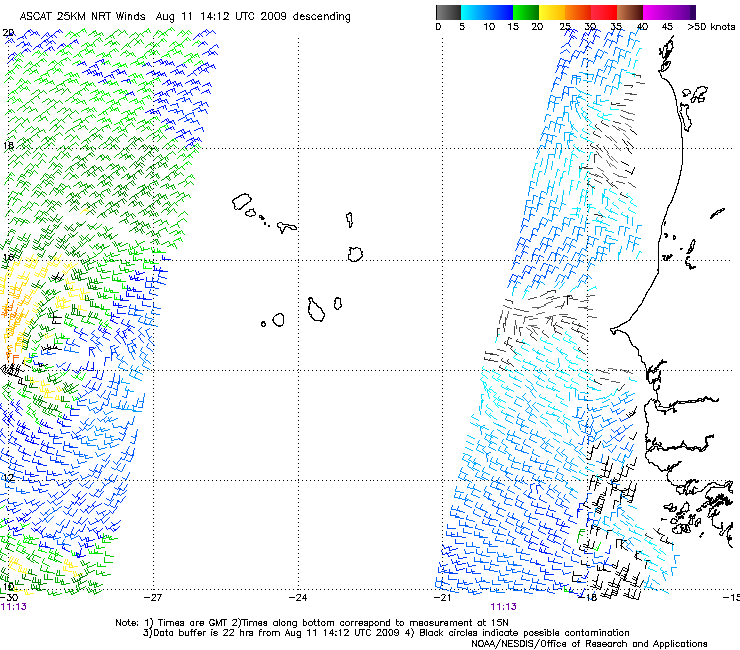
THE DEPRESSION IS A LITTLE THIN ON DEEP CONVECTION AT THE
MOMENT...BUT IT STILL HAS A SMALL WELL-DEFINED LOW-LEVEL
CIRCULATION. AN 1114 UTC ASCAT PASS INDICATED THAT MAXIMUM WINDS
ARE 25 KT...LIMITED TO THE WESTERN SIDE OF THE CIRCULATION...AND
THE INITIAL INTENSITY IS HELD AT THAT INTENSITY FOR THIS ADVISORY.
IN GENERAL...THE NUMERICAL GUIDANCE IS NOT ALL THAT AGGRESSIVE IN
SHOWING INTENSIFICATION OF THIS SYSTEM. SEA SURFACE TEMPERATURES
ALONG THE FORECAST TRACK WILL BE MARGINALLY WARM...AND THE
DEPRESSION WILL HAVE TO ENDURE SOME DRY AIR IN THE MID-LEVELS.
NONETHELESS...VERTICAL SHEAR IS EXPECTED TO BE LIGHT ENOUGH DURING
THE FIRST FOUR DAYS OR SO TO ALLOW SOME SLOW STRENGTHENING. THE
SYSTEM COULD MOVE FAR ENOUGH NORTH BY DAY 5 THAT IT BEGINS TO FEEL
THE EFFECTS OF UPPER-LEVEL WESTERLY WINDS...AND THE OFFICIAL
FORECAST INDICATES SOME WEAKENING BY THEN. IT MUST BE STATED AGAIN
THAT IF THE DEPRESSION TAKES A MORE SOUTHERN TRACK...IT WOULD STAY
AWAY FROM THE INCREASING SHEAR AND COULD POSSIBLY BECOME STRONGER
THAN INDICATED HERE.
THE DEPRESSION IS MOVING AT 275/11. LITTLE CHANGE TO THIS MOTION IS
EXPECTED OVER THE NEXT 3 DAYS DUE TO A MID-LEVEL SUBTROPICAL RIDGE
FORECAST TO PERSIST NORTH OF THE DEPRESSION. BY DAYS 4 AND 5...A
WEAKNESS IS EXPECTED TO DEVELOP IN THE RIDGE OVER THE CENTRAL
ATLANTIC AND CAUSE THE SYSTEM TO TURN SLIGHTLY TO THE WEST-
NORTHWEST. THE NEW OFFICIAL FORECAST IS SHIFTED A LITTLE TO THE
SOUTH BUT STILL LIES NORTH AND EAST OF THE GFDL...HWRF...AND THE
MODEL CONSENSUS TVCN.
FORECAST POSITIONS AND MAX WINDS
INITIAL 11/1500Z 14.6N 29.6W 25 KT
12HR VT 12/0000Z 14.7N 31.3W 30 KT
24HR VT 12/1200Z 14.8N 33.6W 35 KT
36HR VT 13/0000Z 14.9N 35.8W 35 KT
48HR VT 13/1200Z 15.1N 38.2W 40 KT
72HR VT 14/1200Z 16.0N 43.0W 45 KT
96HR VT 15/1200Z 17.5N 47.5W 50 KT
120HR VT 16/1200Z 20.0N 52.0W 45 KT
$$
FORECASTER BERG
WTNT32 KNHC 111445
TCPAT2
BULLETIN
TROPICAL DEPRESSION TWO ADVISORY NUMBER 2
NWS TPC/NATIONAL HURRICANE CENTER MIAMI FL AL022009
1100 AM AST TUE AUG 11 2009
...DEPRESSION MOVING WESTWARD...NO CHANGE IN INTENSITY...
AT 1100 AM AST...1500 UTC...THE CENTER OF TROPICAL DEPRESSION TWO
WAS LOCATED NEAR LATITUDE 14.6 NORTH...LONGITUDE 29.6 WEST OR ABOUT
350 MILES...560 KM...WEST OF THE SOUTHERNMOST CAPE VERDE ISLANDS.
THE DEPRESSION IS MOVING TOWARD THE WEST NEAR 13 MPH...20 KM/HR...
AND THIS GENERAL MOTION IS EXPECTED TO CONTINUE OVER THE NEXT
COUPLE OF DAYS.
MAXIMUM SUSTAINED WINDS ARE NEAR 30 MPH...45 KM/HR...WITH HIGHER
GUSTS. SOME SLOW STRENGTHENING IS FORECAST DURING THE NEXT 24
HOURS...AND THE DEPRESSION COULD BECOME A TROPICAL STORM IN A DAY
OR TWO.
ESTIMATED MINIMUM CENTRAL PRESSURE IS 1006 MB...29.71 INCHES.
...SUMMARY OF 1100 AM AST INFORMATION...
LOCATION...14.6N 29.6W
MAXIMUM SUSTAINED WINDS...30 MPH
PRESENT MOVEMENT...WEST OR 275 DEGREES AT 13 MPH
MINIMUM CENTRAL PRESSURE...1006 MB
THE NEXT ADVISORY WILL BE ISSUED BY THE NATIONAL HURRICANE CENTER AT
500 PM AST.
$$
FORECASTER BERG
949
WTNT42 KNHC 111445
TCDAT2
TROPICAL DEPRESSION TWO DISCUSSION NUMBER 2
NWS TPC/NATIONAL HURRICANE CENTER MIAMI FL AL022009
1100 AM AST TUE AUG 11 2009
THE DEPRESSION IS A LITTLE THIN ON DEEP CONVECTION AT THE
MOMENT...BUT IT STILL HAS A SMALL WELL-DEFINED LOW-LEVEL
CIRCULATION. AN 1114 UTC ASCAT PASS INDICATED THAT MAXIMUM WINDS
ARE 25 KT...LIMITED TO THE WESTERN SIDE OF THE CIRCULATION...AND
THE INITIAL INTENSITY IS HELD AT THAT INTENSITY FOR THIS ADVISORY.
IN GENERAL...THE NUMERICAL GUIDANCE IS NOT ALL THAT AGGRESSIVE IN
SHOWING INTENSIFICATION OF THIS SYSTEM. SEA SURFACE TEMPERATURES
ALONG THE FORECAST TRACK WILL BE MARGINALLY WARM...AND THE
DEPRESSION WILL HAVE TO ENDURE SOME DRY AIR IN THE MID-LEVELS.
NONETHELESS...VERTICAL SHEAR IS EXPECTED TO BE LIGHT ENOUGH DURING
THE FIRST FOUR DAYS OR SO TO ALLOW SOME SLOW STRENGTHENING. THE
SYSTEM COULD MOVE FAR ENOUGH NORTH BY DAY 5 THAT IT BEGINS TO FEEL
THE EFFECTS OF UPPER-LEVEL WESTERLY WINDS...AND THE OFFICIAL
FORECAST INDICATES SOME WEAKENING BY THEN. IT MUST BE STATED AGAIN
THAT IF THE DEPRESSION TAKES A MORE SOUTHERN TRACK...IT WOULD STAY
AWAY FROM THE INCREASING SHEAR AND COULD POSSIBLY BECOME STRONGER
THAN INDICATED HERE.
THE DEPRESSION IS MOVING AT 275/11. LITTLE CHANGE TO THIS MOTION IS
EXPECTED OVER THE NEXT 3 DAYS DUE TO A MID-LEVEL SUBTROPICAL RIDGE
FORECAST TO PERSIST NORTH OF THE DEPRESSION. BY DAYS 4 AND 5...A
WEAKNESS IS EXPECTED TO DEVELOP IN THE RIDGE OVER THE CENTRAL
ATLANTIC AND CAUSE THE SYSTEM TO TURN SLIGHTLY TO THE WEST-
NORTHWEST. THE NEW OFFICIAL FORECAST IS SHIFTED A LITTLE TO THE
SOUTH BUT STILL LIES NORTH AND EAST OF THE GFDL...HWRF...AND THE
MODEL CONSENSUS TVCN.
FORECAST POSITIONS AND MAX WINDS
INITIAL 11/1500Z 14.6N 29.6W 25 KT
12HR VT 12/0000Z 14.7N 31.3W 30 KT
24HR VT 12/1200Z 14.8N 33.6W 35 KT
36HR VT 13/0000Z 14.9N 35.8W 35 KT
48HR VT 13/1200Z 15.1N 38.2W 40 KT
72HR VT 14/1200Z 16.0N 43.0W 45 KT
96HR VT 15/1200Z 17.5N 47.5W 50 KT
120HR VT 16/1200Z 20.0N 52.0W 45 KT
$$
FORECASTER BERG
0 likes
-
luvcanescarol
- Tropical Low

- Posts: 28
- Joined: Sun Jul 10, 2005 3:21 am
- Location: Wayne, NJ
Re: ATL : TROPICAL DEPRESSION TWO
All I can say is it's been way too long since I had something to track, and hope the season is really ramping up. I've missed this!
0 likes
-
HurricaneRobert
- Category 3

- Posts: 812
- Joined: Fri May 18, 2007 9:31 pm
-
HURAKAN
- Professional-Met
- Posts: 46084
- Age: 39
- Joined: Thu May 20, 2004 4:34 pm
- Location: Key West, FL
- Contact:
Re: ATL : TROPICAL DEPRESSION TWO
HurricaneRobert wrote:This looks awful and yet there are 17 pages on it.
Can you find anything better in the Atlantic?
0 likes
-
Evil Jeremy
- S2K Supporter
- Posts: 5463
- Age: 32
- Joined: Mon Apr 10, 2006 2:10 pm
- Location: Los Angeles, CA
Re: ATL : TROPICAL DEPRESSION TWO
HurricaneRobert wrote:This looks awful and yet there are 17 pages on it.
Thats what you get when your in the middle of August and only on your second TD of the season. Anyways, for a TD, I would say this looks good. A little low on convection at the moment, but well orginized.
0 likes
-
Jevo

- S2K Supporter
- Posts: 1729
- Age: 47
- Joined: Tue Aug 03, 2004 8:45 pm
- Location: The Flemish Cap
- Contact:
Re: ATL: TROPICAL DEPRESSION TWO (Models)
Its always fun watching a long tracker and having it hang a right out to sea just before the Bahamas
0 likes

-
Blown Away

- S2K Supporter
- Posts: 10253
- Joined: Wed May 26, 2004 6:17 am
Re: ATL: TROPICAL DEPRESSION TWO (Models)
Am I reading the 06Z GFS model correctly? I think it sends a weak TD2 through the FL Straits and rate behind it is the wave coming off Africa that takes a Donna type track. 
http://www.nco.ncep.noaa.gov/pmb/nwprod ... loop.shtml
http://www.nco.ncep.noaa.gov/pmb/nwprod ... loop.shtml
0 likes
-
BensonTCwatcher

- Category 5
- Posts: 1050
- Joined: Sat Aug 28, 2004 10:11 pm
- Location: Southport NC
Re: ATL : TROPICAL DEPRESSION TWO
And so we Track and watch an analyze. This is what we are here for. At least we are looking at an organized circulation. By the way, WxMan's prediction of an named storm Aug 8th is busted long...if I'm not mistaken. Who'da thunkit? especially when he made it.
Anyways I'd guess this has a better than 50% chance of surviving a week to 10 days if it stays out of teh cool water and shear to the North.
Anyways I'd guess this has a better than 50% chance of surviving a week to 10 days if it stays out of teh cool water and shear to the North.
0 likes
-
wxman57
- Moderator-Pro Met
- Posts: 23172
- Age: 68
- Joined: Sat Jun 21, 2003 8:06 pm
- Location: Houston, TX (southwest)
Re: ATL : TROPICAL DEPRESSION TWO
BensonTCwatcher wrote:And so we Track and watch an analyze. This is what we are here for. At least we are looking at an organized circulation. By the way, WxMan's prediction of an named storm Aug 8th is busted long...if I'm not mistaken. Who'da thunkit? especially when he made it. .
I was a bit disappointed when my May prediction of August 8th passed without Ana. But I'd take the 11th or 12th as pretty close.
0 likes
-
BensonTCwatcher
- Category 5
- Posts: 1050
- Joined: Sat Aug 28, 2004 10:11 pm
- Location: Southport NC
Who is online
Users browsing this forum: No registered users and 19 guests