ATL: TROPICAL DEPRESSION ANA (02L)

Moderator: S2k Moderators

Message
Author
User avatar
Gustywind
Category 5
Category 5
Posts: 12334
Joined: Mon Sep 03, 2007 7:29 am
Location: Baie-Mahault, GUADELOUPE

Re: ATL : INVEST 99L

#281 Postby Gustywind » Mon Aug 10, 2009 8:12 pm

cycloneye wrote:
brunota2003 wrote:
cycloneye wrote:For now its not climbing in latitud.In fact it decended a little.

DATE/TIME LAT LON CLASSIFICATION STORM
10/2345 UTC 14.1N 26.7W T1.0/1.5 99L

10/1745 UTC 14.4N 25.8W T1.0/1.5 99L
10/1145 UTC 14.3N 24.5W T1.5/1.5 99L
10/0545 UTC 14.2N 23.9W T1.5/1.5 99L
09/2345 UTC 14.2N 22.9W T1.5/1.5 99L
09/1745 UTC 14.2N 22.4W T1.5/1.5 99L
09/1330 UTC 14.2N 21.8W T1.5/1.5 99L

http://www.ssd.noaa.gov/PS/TROP/tdpositions.html

I would hate to disagree, but it did indeed climb.

09/1330 14.2 N
10/1745 14.4 N

You looked at it upside down ;)


The first one at the top is the most recent one (14.1N) and I separated it from the rest of the positions to highlight it. :)

Hey Cycloneye, maybe his "untrained eyes "missed the most recent position :oops: :cheesy:
0 likes   

User avatar
brunota2003
S2K Supporter
S2K Supporter
Posts: 9476
Age: 34
Joined: Sat Jul 30, 2005 9:56 pm
Location: Stanton, KY...formerly Havelock, NC
Contact:

#282 Postby brunota2003 » Mon Aug 10, 2009 8:18 pm

Yes yes, my...been away from the tropics for a while eyes missed it :lol:
0 likes   

User avatar
HURAKAN
Professional-Met
Professional-Met
Posts: 46086
Age: 38
Joined: Thu May 20, 2004 4:34 pm
Location: Key West, FL
Contact:

#283 Postby HURAKAN » Mon Aug 10, 2009 8:20 pm

This is getting ridiculous. The CPAC may get two named systems before the Atlantic has one. Incredible.
0 likes   

User avatar
srainhoutx
S2K Supporter
S2K Supporter
Posts: 6919
Age: 67
Joined: Sun Jan 14, 2007 11:34 am
Location: Haywood County, NC
Contact:

Re: ATL : INVEST 99L

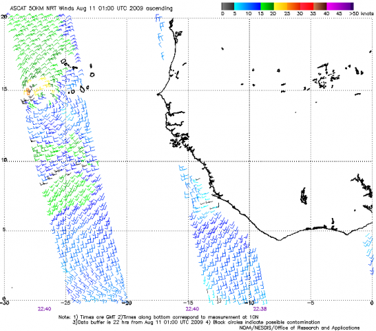
#284 Postby srainhoutx » Mon Aug 10, 2009 8:21 pm

Hmmm...

Image
0 likes   

User avatar
Gustywind
Category 5
Category 5
Posts: 12334
Joined: Mon Sep 03, 2007 7:29 am
Location: Baie-Mahault, GUADELOUPE

Re:

#285 Postby Gustywind » Mon Aug 10, 2009 8:23 pm

brunota2003 wrote:Yes yes, my...been away from the tropics for a while eyes missed it :lol:

:wink: no problem my friend that's 8-) glad to see that you informed us about that... :) :lol:
0 likes   

User avatar
HURAKAN
Professional-Met
Professional-Met
Posts: 46086
Age: 38
Joined: Thu May 20, 2004 4:34 pm
Location: Key West, FL
Contact:

#286 Postby HURAKAN » Mon Aug 10, 2009 8:24 pm

Image

A lot has changed in the past few days
0 likes   

User avatar
cycloneye
Admin
Admin
Posts: 145299
Age: 68
Joined: Thu Oct 10, 2002 10:54 am
Location: San Juan, Puerto Rico

Re:

#287 Postby cycloneye » Mon Aug 10, 2009 8:25 pm

HURAKAN wrote:This is getting ridiculous. The CPAC may get two named systems before the Atlantic has one. Incredible.


And to complete the ridiculous thing about this,the CPAC has 5.33 ACE numbers while the North Atlantic has zeros.I cant believe for a minute that the CPAC will finish ahead of the Atlantic when 2009 goes.
0 likes   

User avatar
HURAKAN
Professional-Met
Professional-Met
Posts: 46086
Age: 38
Joined: Thu May 20, 2004 4:34 pm
Location: Key West, FL
Contact:

Re: Re:

#288 Postby HURAKAN » Mon Aug 10, 2009 8:27 pm

cycloneye wrote:
HURAKAN wrote:This is getting ridiculous. The CPAC may get two named systems before the Atlantic has one. Incredible.


And to complete the ridiculous thing about this,the CPAC has 5.33 ACE numbers while the North Atlantic has zeros.I cant believe for a minute that the CPAC will finish ahead of the Atlantic when 2009 goes.


We just need another Bertha (2008) and we will be OK.
0 likes   

User avatar
gatorcane
S2K Supporter
S2K Supporter
Posts: 23691
Age: 47
Joined: Sun Mar 13, 2005 3:54 pm
Location: Boca Raton, FL

#289 Postby gatorcane » Mon Aug 10, 2009 8:45 pm

code orange is good for the time being. Don't see Ana still in the next 24-48 hours. Needs to get further west into some warmer SSTs and away from the SAL. It's something to keep any eye on but it won't be impacting land anytime soon if not ever.

The GFS system that develops in 3 days from now will steal the show from this anyway (just my 2 cents).
Last edited by gatorcane on Mon Aug 10, 2009 8:49 pm, edited 3 times in total.
0 likes   

User avatar
Emmett_Brown
Category 5
Category 5
Posts: 1432
Joined: Wed Aug 24, 2005 9:10 pm
Location: Sarasota FL

Re: ATL : INVEST 99L

#290 Postby Emmett_Brown » Mon Aug 10, 2009 8:45 pm

srainhoutx wrote:Hmmm...

Image


Looks better than it ever has on QuickSCAT... actually looking like a legit LLC forming, even if the IR looks ragged. Might still have a chance.
0 likes   

User avatar
srainhoutx
S2K Supporter
S2K Supporter
Posts: 6919
Age: 67
Joined: Sun Jan 14, 2007 11:34 am
Location: Haywood County, NC
Contact:

Re: ATL : INVEST 99L

#291 Postby srainhoutx » Mon Aug 10, 2009 8:57 pm

Emmett_Brown wrote:
srainhoutx wrote:Hmmm...

Image


Looks better than it ever has on QuickSCAT... actually looking like a legit LLC forming, even if the IR looks ragged. Might still have a chance.


Models are struggling at best what to latch on to IMHO.
0 likes   

User avatar
HURAKAN
Professional-Met
Professional-Met
Posts: 46086
Age: 38
Joined: Thu May 20, 2004 4:34 pm
Location: Key West, FL
Contact:

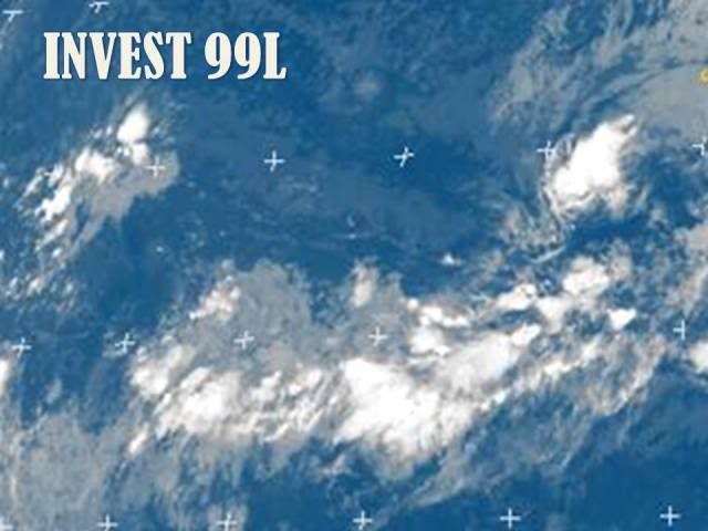
#292 Postby HURAKAN » Mon Aug 10, 2009 9:19 pm

Image

As long it keeps producing some convection, 99L will be alive.
0 likes   

User avatar
HURAKAN
Professional-Met
Professional-Met
Posts: 46086
Age: 38
Joined: Thu May 20, 2004 4:34 pm
Location: Key West, FL
Contact:

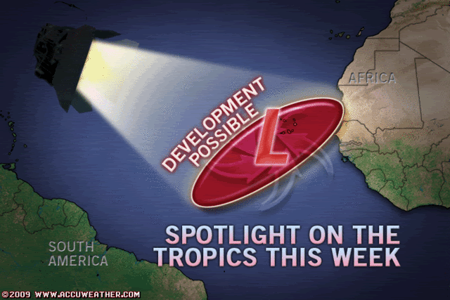
#293 Postby HURAKAN » Mon Aug 10, 2009 9:20 pm

Image

Accuweather's take
0 likes   

User avatar
brunota2003
S2K Supporter
S2K Supporter
Posts: 9476
Age: 34
Joined: Sat Jul 30, 2005 9:56 pm
Location: Stanton, KY...formerly Havelock, NC
Contact:

#294 Postby brunota2003 » Mon Aug 10, 2009 9:24 pm

They're a tad late...
0 likes   

jinftl
Category 5
Category 5
Posts: 4312
Joined: Tue Aug 31, 2004 4:47 pm
Location: fort lauderdale, fl

Re: Re:

#295 Postby jinftl » Mon Aug 10, 2009 9:25 pm

as long as it keeps some convection...but doesn't develop much....it will gain longitude....like we always say on here, the storms that develop in the far eastern atlantic are usually 'fish', the ones that hold together but don't develop signifcantly until further west are often the most troublesome storms.

HURAKAN wrote:Image

As long it keeps producing some convection, 99L will be alive.
0 likes   

User avatar
Dr. Strangelove
Tropical Low
Tropical Low
Posts: 14
Joined: Mon Aug 03, 2009 12:26 pm

Re:

#296 Postby Dr. Strangelove » Mon Aug 10, 2009 9:25 pm

HURAKAN wrote:Image

Accuweather's take


Brilliant.
0 likes   

Aric Dunn
Category 5
Category 5
Posts: 21238
Age: 42
Joined: Sun Sep 19, 2004 9:58 pm
Location: Ready for the Chase.
Contact:

#297 Postby Aric Dunn » Mon Aug 10, 2009 9:52 pm

its starting to pop for sure.. once we start seeing those -60 ,-70 degree cloud tops its a sign that low level convergence and moisture is increasing... now lets see if it can expand some more..
0 likes   

User avatar
Blown Away
S2K Supporter
S2K Supporter
Posts: 10145
Joined: Wed May 26, 2004 6:17 am

Re: ATL : INVEST 99L

#298 Postby Blown Away » Mon Aug 10, 2009 9:56 pm

HPC Caribbean Disco...snipet...

TROPICAL DISCUSSION - INTERNATIONAL DESKS
NWS HYDROMETEOROLOGICAL PREDICTION CENTER CAMP SPRINGS MD
251 PM EDT MON AUG 10 2009

EXTENDED OUTLOOK: THE EMPIRICAL WAVE PROPAGATION MODELS MAINTAINS
GOOD CONTINUITY WITH PREVIOUS FORECASTS...SHOWING MJO CONDITIONS
ACROSS NORTHERN SOUTH AMERICA INTO THE TROPICAL ATLANTIC IMPROVING
THROUGH MID AUGUST...WITH CONDITIONS TO REMAIN FAVORABLE THROUGH
THE END OF THE MONTH-FIRST WEEK IN SEPTEMBER. THE GLOBAL MODELS
ARE STARTING TO REACT TO THE CHANGE IN CONDITIONS/
ENVIRONMENT...AS THEY NOW SHOW RISK OF WARM CORE CYCLOGENESIS ON
BOTH OCEANS. AT UPPER LEVELS A CELL OF THE SUBTROPICAL RIDGE WILL
MEANDER NORTH OF THE GREATER ANTILLES/OFF THE COAST OF THE
USA...WHICH IS TO THEN SUSTAIN A TROUGH OVER THE CENTRAL ATLANTIC.
A WEAK/NARROW RIDGE IS TO THEN REMAIN TO THE SOUTH OF 23N. IF THIS
PATTERN PERSIST...TROPICAL CYCLONES FORMING OFF THE COAST OF
AFRICA ARE LIKELY TO TURN TOWARDS THE NORTH AS THEY ARE ABOUT TO
REACH THE ISLAND CHAIN. THE ONES FORMING TO THE WEST OF 45W ARE UP
FOR GRAB...AS THEY ARE LIKELY TO THREATEN THE ISLAND CHAIN-PUERTO
RICO/DOMINICAN REPUBLIC.


This discussion was posted under another thread, but I thought it would give us an idea on what to expect if these waves develope.
0 likes   

User avatar
Annie Oakley
Category 5
Category 5
Posts: 1103
Joined: Tue Jul 31, 2007 12:54 pm
Location: Texas

Re: Re:

#299 Postby Annie Oakley » Mon Aug 10, 2009 10:33 pm

jinftl wrote:as long as it keeps some convection...but doesn't develop much....it will gain longitude....like we always say on here, the storms that develop in the far eastern atlantic are usually 'fish', the ones that hold together but don't develop signifcantly until further west are often the most troublesome storms.

HURAKAN wrote:Image

As long it keeps producing some convection, 99L will be alive.

It is still such a pretty thing...so wild. Have to admit-it is beyond us to tell it what to do or where to go-Nature Rules
0 likes   

User avatar
HURAKAN
Professional-Met
Professional-Met
Posts: 46086
Age: 38
Joined: Thu May 20, 2004 4:34 pm
Location: Key West, FL
Contact:

#300 Postby HURAKAN » Mon Aug 10, 2009 10:34 pm

Image

Looking a lot better compared to a few hours ago
0 likes   


Return to “2009”

Who is online

Users browsing this forum: No registered users and 2 guests