New disturbance emerging from Africa
Moderator: S2k Moderators
Forum rules

The posts in this forum are NOT official forecasts and should not be used as such. They are just the opinion of the poster and may or may not be backed by sound meteorological data. They are NOT endorsed by any professional institution or STORM2K. For official information, please refer to products from the National Hurricane Center and National Weather Service.
-
Blown Away

- S2K Supporter

- Posts: 10253
- Joined: Wed May 26, 2004 6:17 am
Re: New disturbance emerging from Africa
Let's talk about where this wave is going over the next few days. I say if the LLC consolidates above 15N I say very little chance of affecting the Islands or EC. Below 15N, game on!
0 likes


-
Brent
- S2K Supporter
- Posts: 38790
- Age: 37
- Joined: Sun May 16, 2004 10:30 pm
- Location: Tulsa Oklahoma
- Contact:
Re: New disturbance emerging from Africa
Continues to look extremely impressive... I think this is going to be Ana.
0 likes
-
HurricaneMaster_PR

- Category 2

- Posts: 795
- Joined: Tue Jul 22, 2003 6:23 pm
- Location: San Juan, Puerto Rico


-
Ed Mahmoud
Re: New disturbance emerging from Africa
GFS says fish, and this probably opens a path for the next system to fish as well.
Two fish storms, everyone happy, then 3 months to the start of Texas Snow Miracle Season.

Two fish storms, everyone happy, then 3 months to the start of Texas Snow Miracle Season.
0 likes
-
SouthFloridawx

- S2K Supporter
- Posts: 8346
- Age: 47
- Joined: Tue Jul 26, 2005 1:16 am
- Location: Sarasota, FL
- Contact:

-
Ed Mahmoud
Re: New disturbance emerging from Africa
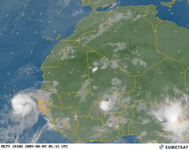
24 hour hour drop from 1014 to 1012 at Sal, Republica de Cabo Verde. Only ob I can find, the capital, Praia, would be more interesting

Ok, found Praia, not exciting yet
http://www.wunderground.com/global/stations/08589.html
Ok, found Praia, not exciting yet
http://www.wunderground.com/global/stations/08589.html
0 likes
-
Ed Mahmoud
Re: New disturbance emerging from Africa
S. Fl. Wx- looks invest worthy, maybe even a TD, to my amateur eyes.
0 likes
-
mcallum177
- Tropical Depression

- Posts: 98
- Joined: Sun Jun 14, 2009 12:39 am
- Location: Dallas, TX
-
SETXWXLADY
- Tropical Storm

- Posts: 216
- Joined: Wed May 20, 2009 3:26 pm
- Location: SE TX Orange County
Re:
mcallum177 wrote:What is a fish?
It's a storm or hurricane that doesn't hit land and is just a concern to fish or ships.
0 likes
-
Derek Ortt
Re: New disturbance emerging from Africa
Ed Mahmoud wrote:GFS says fish, and this probably opens a path for the next system to fish as well.
Two fish storms, everyone happy, then 3 months to the start of Texas Snow Miracle Season.
second one does not = recurve just because the first one does
0 likes
-
SETXWXLADY
- Tropical Storm
- Posts: 216
- Joined: Wed May 20, 2009 3:26 pm
- Location: SE TX Orange County
Re: New disturbance emerging from Africa
Can't post a pick. I'll try a link. Just thought was interesting the CMC 240hr has a low sitting right below Florida on the 19th. Of course that can and will probably change. Most likely before anyone sees this post. Lol.
http://meteocentre.com/models/glb00_240_e.html
Ok. Hope that worked.
http://meteocentre.com/models/glb00_240_e.html
Ok. Hope that worked.
0 likes
-
cycloneye

- Admin

- Posts: 149840
- Age: 69
- Joined: Thu Oct 10, 2002 10:54 am
- Location: San Juan, Puerto Rico
Re: New disturbance emerging from Africa
Code Orange
784
ABNT20 KNHC 091153
TWOAT
TROPICAL WEATHER OUTLOOK
NWS TPC/NATIONAL HURRICANE CENTER MIAMI FL
800 AM EDT SUN AUG 9 2009
FOR THE NORTH ATLANTIC...CARIBBEAN SEA AND THE GULF OF MEXICO...
A LOW PRESSURE AREA ASSOCIATED WITH A TROPICAL WAVE IS PRODUCING AN
AREA OF SHOWERS AND THUNDERSTORMS BETWEEN THE CAPE VERDE ISLANDS
AND THE COAST OF AFRICA. THIS SYSTEM IS SHOWING SOME SIGNS OF
ORGANIZATION AND COULD BECOME A TROPICAL DEPRESSION DURING THE NEXT
COUPLE OF DAYS AS IT MOVES WESTWARD AT 10 TO 15 MPH. THERE IS A
MEDIUM CHANCE...30 TO 50 PERCENT...OF THIS SYSTEM BECOMING A
TROPICAL CYCLONE DURING THE NEXT 48 HOURS. REGARDLESS OF
DEVELOPMENT...SHOWERS AND THUNDERSTORMS WITH LOCALLY GUSTY WINDS
COULD AFFECT PORTIONS OF THE CAPE VERDE ISLANDS OVER THE NEXT
COUPLE OF DAYS.
ELSEWHERE...TROPICAL CYCLONE FORMATION IS NOT EXPECTED DURING THE
NEXT 48 HOURS.
$$
FORECASTER BERG
0 likes


Re: New disturbance emerging from Africa
Looks like the cape verde season is going to heat up over the next week or so. Latest GFS 15-day model runs are storms gone wild with at least three disturbances or more developing. This wave, as commented by others, already looks INVEST worthy and may become Ana down the road. Interesting that the GFS has consistently made this a fish spinner while the CMC, NOGAPs, and UKMET keep the system much further south and westward - the big difference between the models is that GFS develops low pressure at a higher LAT and much more aggressively then the other models. All of the models also develop a second disturbance coming off Africa in 3-5 days.
0 likes
Re: New disturbance emerging from Africa
cycloneye wrote:I smell that this thread will be locked shortly.
Yeah refresh alert on the NRL page now.
0 likes
-
cycloneye
- Admin
- Posts: 149840
- Age: 69
- Joined: Thu Oct 10, 2002 10:54 am
- Location: San Juan, Puerto Rico
Re: New disturbance emerging from Africa
In fact I spoke minutes before it happened.Is INVEST 99L!! Thread is locked.Go to active storms forum to continue the discussions and get all the information about the system.
Link to 99L thread.
viewtopic.php?f=59&t=106100&hilit=&p=1899320#p1899320
Link to 99L thread.
viewtopic.php?f=59&t=106100&hilit=&p=1899320#p1899320
0 likes
Who is online
Users browsing this forum: No registered users and 38 guests