There is nothing else to watch!
Moderator: S2k Moderators


KWT wrote:Mind you look where they are starting it, probably quite a bit too far north of where any developing system would be at the moment, which no doubt makes a difference in terms of what the models expect.
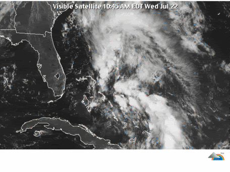
ABNT20 KNHC 222327
TWOAT
TROPICAL WEATHER OUTLOOK
NWS TPC/NATIONAL HURRICANE CENTER MIAMI FL
800 PM EDT WED JUL 22 2009
FOR THE NORTH ATLANTIC...CARIBBEAN SEA AND THE GULF OF MEXICO...
A LARGE AREA OF DISORGANIZED CLOUDINESS AND THUNDERSTORMS EXTENDING
FROM THE BAHAMAS NORTHWARD ACROSS THE ATLANTIC FOR SEVERAL HUNDRED
MILES IS ASSOCIATED WITH A WEAK SURFACE TROUGH INTERACTING WITH AN
UPPER-LEVEL LOW. THERE ARE NO SIGNS OF A SURFACE CIRCULATION AND
UPPER-LEVEL WINDS ARE FORECAST TO BECOME LESS FAVORABLE FOR
DEVELOPMENT. THIS ACTIVITY IS EXPECTED TO MOVE NORTHWARD OR
NORTHEASTWARD AT ABOUT 20 MPH OVER THE NEXT DAY OR SO. THERE IS A
LOW CHANCE...LESS THAN 30 PERCENT...OF THIS SYSTEM BECOMING A
TROPICAL OR SUBTROPICAL CYCLONE DURING THE NEXT 48 HOURS.
ELSEWHERE...TROPICAL CYCLONE FORMATION IS NOT EXPECTED DURING THE
NEXT 48 HOURS.
$$
FORECASTER AVILA


Ed Mahmoud wrote:HURAKAN wrote:
Can we use HAARP to get Ana from this? Sorry, I couldn't help it after that HC show!!!
It would sort of be cheating, but probably the only chance of a July 21-July 31 first named system.
Unfair, I had ten days, August is an entire month...


Users browsing this forum: hurricanes1234 and 26 guests


