Another Little system over Canary Islands..

This is the general tropical discussion area. Anyone can take their shot at predicting a storms path.

Moderator: S2k Moderators

Forum rules

The posts in this forum are NOT official forecasts and should not be used as such. They are just the opinion of the poster and may or may not be backed by sound meteorological data. They are NOT endorsed by any professional institution or STORM2K. For official information, please refer to products from the National Hurricane Center and National Weather Service.

Help Support Storm2K
Message
Author
User avatar
DanieleItalyRm
Category 1
Category 1
Posts: 487
Age: 39
Joined: Mon Sep 22, 2008 7:52 am
Location: Rome - Italy - Mediterranean sea

Another Little system over Canary Islands..

#1 Postby DanieleItalyRm » Thu Jun 18, 2009 7:08 am

On 15-16-17-18 th (today) Jun a low system developed over Azores Islands from a big thunderstorm system:

Image

15th jun 09:
Image

16th jun 09:
Image

On 17th the little low moved south-west, over the Canary Islands..

12:00
Image

15:00
Image

18:00
Image

20:00
Image

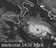
In the last night, the thunderstorm activity increase in the center.. it like a tropical depression, max winds 30 knots.

Image

Image

Image

Image

Image
Last edited by DanieleItalyRm on Fri Jun 19, 2009 11:13 am, edited 4 times in total.
0 likes   

User avatar
DanieleItalyRm
Category 1
Category 1
Posts: 487
Age: 39
Joined: Mon Sep 22, 2008 7:52 am
Location: Rome - Italy - Mediterranean sea

#2 Postby DanieleItalyRm » Thu Jun 18, 2009 10:04 am

Today, 18th, continue the convection in the center..the storm moved on north-north east:

Image
Last edited by DanieleItalyRm on Fri Jun 19, 2009 11:29 am, edited 3 times in total.
0 likes   

User avatar
brunota2003
S2K Supporter
S2K Supporter
Posts: 9476
Age: 34
Joined: Sat Jul 30, 2005 9:56 pm
Location: Stanton, KY...formerly Havelock, NC
Contact:

#3 Postby brunota2003 » Thu Jun 18, 2009 10:06 am

I highly doubt it is warm core though.
0 likes   

User avatar
HURAKAN
Professional-Met
Professional-Met
Posts: 46086
Age: 38
Joined: Thu May 20, 2004 4:34 pm
Location: Key West, FL
Contact:

#4 Postby HURAKAN » Thu Jun 18, 2009 10:09 am

It has a lot of work to do! But these systems are always interesting!
0 likes   

User avatar
DanieleItalyRm
Category 1
Category 1
Posts: 487
Age: 39
Joined: Mon Sep 22, 2008 7:52 am
Location: Rome - Italy - Mediterranean sea

Re:

#5 Postby DanieleItalyRm » Thu Jun 18, 2009 10:17 am

brunota2003 wrote:I highly doubt it is warm core though.

for me have warm core.. it's very little for European cart..
Not possible convection in the center if it is have cold core.
0 likes   

User avatar
Pedro Fernández
Tropical Storm
Tropical Storm
Posts: 233
Age: 47
Joined: Mon Dec 31, 2007 7:24 am
Location: Costa Tropical (Granada, Spain).
Contact:

Another interesting "blob" in the Eastern Atlantic.

#6 Postby Pedro Fernández » Thu Jun 18, 2009 10:21 am

I have known about this issue thank to a friend in our forum, from the Canary Islands (just that you can see in the image)........ Another interesting evolution of an old extratropical low pressure system.

Image

I forgot it: date of the image: 17.06.09, 18 UTC.
0 likes   

User avatar
DanieleItalyRm
Category 1
Category 1
Posts: 487
Age: 39
Joined: Mon Sep 22, 2008 7:52 am
Location: Rome - Italy - Mediterranean sea

#7 Postby DanieleItalyRm » Thu Jun 18, 2009 11:17 am

18th, 15:00
Image
Last edited by DanieleItalyRm on Fri Jun 19, 2009 11:23 am, edited 1 time in total.
0 likes   

User avatar
DanieleItalyRm
Category 1
Category 1
Posts: 487
Age: 39
Joined: Mon Sep 22, 2008 7:52 am
Location: Rome - Italy - Mediterranean sea

Re: Another Little system over Canary Islands..

#8 Postby DanieleItalyRm » Thu Jun 18, 2009 7:01 pm

Image

Image
0 likes   

User avatar
brunota2003
S2K Supporter
S2K Supporter
Posts: 9476
Age: 34
Joined: Sat Jul 30, 2005 9:56 pm
Location: Stanton, KY...formerly Havelock, NC
Contact:

Re: Another Little system over Canary Islands..

#9 Postby brunota2003 » Thu Jun 18, 2009 7:05 pm

From the 805 pm Atlantic Tropical Weather Discussion:

ATLANTIC OCEAN...
A DEEP LAYER CENTRAL ATLC TROUGH IS SUPPORTING A COLD FRONT THAT
ENTERS THE DISCUSSION AREA NEAR 32N52W AND EXTENDS W-SW TO 29N61W
CONTINUING AS A STATIONARY FRONT TO 31N70W AND AS A WARM FRONT FROM
THAT POINT INTO A 1013 MB LOW CENTERED NEAR 32N74W. A SURFACE TROUGH
EXTENDS S-SW FROM THE SURFACE LOW ALONG 30N75W 27N78W 26N80W AND
ACROSS EXTREME SRN FLORIDA INTO THE SE GULF OF MEXICO. ISOLATED
SHOWERS ACCOMPANY THE SURFACE TROUGH N OF 27N W OF 70W. ELSEWHERE...
SCATTERED SHOWERS ARE WITHIN 200 NM N OF THE STATIONARY FRONT
BETWEEN 55W-70W AND WITHIN 150 NM EITHER SIDE OF THE COLD FRONT
BETWEEN 45W-55W. ACROSS THE MAJORITY OF THE CENTRAL AND E ATLC A
BROAD SURFACE RIDGE DOMINATES ANCHORED BY A 1028 MB SURFACE HIGH N
OF THE DISCUSSION AREA NEAR 41N26W. HOWEVER...A DEEP LAYER LOW OVER
THE NE ATLC IS ASSOCIATED WITH A 1015 MB SURFACE LOW NW OF THE
CANARY ISLANDS NEAR 30N19W. LOW LEVEL CONVERGENCE NEAR THIS SURFACE
LOW IS SUPPORTING ISOLATED SHOWERS N OF 30N BETWEEN 17W-24W.
0 likes   

User avatar
DanieleItalyRm
Category 1
Category 1
Posts: 487
Age: 39
Joined: Mon Sep 22, 2008 7:52 am
Location: Rome - Italy - Mediterranean sea

Re: Another Little system over Canary Islands..

#10 Postby DanieleItalyRm » Fri Jun 19, 2009 3:13 am

Like in structur as many tropical depression,with thunderstom activity little north-north east of the center:
Look Tropical Storm Ernesto 1-2-3 September 2000

Image

And the Canary unnamed cyclone 15-16-17-18-19 Jun 2009:

Image
0 likes   

User avatar
DanieleItalyRm
Category 1
Category 1
Posts: 487
Age: 39
Joined: Mon Sep 22, 2008 7:52 am
Location: Rome - Italy - Mediterranean sea

Re: Another Little system over Canary Islands..

#11 Postby DanieleItalyRm » Sat Jun 20, 2009 4:15 am

on the 19th continue the little closed circulation with debol-moderate convection in the center and 30 knots winds:

Image

day:
Image

evening:
Image
0 likes   

User avatar
senorpepr
Military Met/Moderator
Posts: 12542
Age: 43
Joined: Fri Aug 22, 2003 9:22 pm
Location: Mackenbach, Germany
Contact:

#12 Postby senorpepr » Sat Jun 20, 2009 8:29 pm

Definately NOT warm core. Actually, there's a marked cold pocket aloft at 500 hPa. This is creating a pretty steep lapse rate between this cold pocket and the (relatively) warm ocean surface. This steep lapse rate is allowing for convection to form.
0 likes   

User avatar
brunota2003
S2K Supporter
S2K Supporter
Posts: 9476
Age: 34
Joined: Sat Jul 30, 2005 9:56 pm
Location: Stanton, KY...formerly Havelock, NC
Contact:

Re:

#13 Postby brunota2003 » Sat Jun 20, 2009 9:07 pm

senorpepr wrote:Definately NOT warm core. Actually, there's a marked cold pocket aloft at 500 hPa. This is creating a pretty steep lapse rate between this cold pocket and the (relatively) warm ocean surface. This steep lapse rate is allowing for convection to form.

So does that mean the cold pocket is behaving similar to a cold front? The warm(ish) air close to the ocean's surface is trapped beneath the colder air as it advances, and then tries to rise up, creating the updrafts that lead to the storms? (warm air rises...I know that much xD)
0 likes   

User avatar
senorpepr
Military Met/Moderator
Posts: 12542
Age: 43
Joined: Fri Aug 22, 2003 9:22 pm
Location: Mackenbach, Germany
Contact:

#14 Postby senorpepr » Sat Jun 20, 2009 9:57 pm

Sort of. It's not really cold air advancing, but rather cold air "trapped" over the circulation.
0 likes   

User avatar
brunota2003
S2K Supporter
S2K Supporter
Posts: 9476
Age: 34
Joined: Sat Jul 30, 2005 9:56 pm
Location: Stanton, KY...formerly Havelock, NC
Contact:

#15 Postby brunota2003 » Sat Jun 20, 2009 10:48 pm

Yes, but the whole circulation is advancing, and with it the cold pool, correct?
0 likes   

User avatar
senorpepr
Military Met/Moderator
Posts: 12542
Age: 43
Joined: Fri Aug 22, 2003 9:22 pm
Location: Mackenbach, Germany
Contact:

#16 Postby senorpepr » Sat Jun 20, 2009 10:51 pm

Yes, but the cold pocket isn't advance on the circulation. That's my point. That's how it's sustaining some convection over the circulation.
0 likes   

User avatar
brunota2003
S2K Supporter
S2K Supporter
Posts: 9476
Age: 34
Joined: Sat Jul 30, 2005 9:56 pm
Location: Stanton, KY...formerly Havelock, NC
Contact:

#17 Postby brunota2003 » Sat Jun 20, 2009 11:00 pm

Which means that it is not latent heat being released aiding the storms (warm core) but instead the dynamics associated with something similar to a small scale cold front or sea breeze. Bleh...trying to think of a good example and it isnt working >>
0 likes   

User avatar
DanieleItalyRm
Category 1
Category 1
Posts: 487
Age: 39
Joined: Mon Sep 22, 2008 7:52 am
Location: Rome - Italy - Mediterranean sea

Re: Another Little system over Canary Islands..

#18 Postby DanieleItalyRm » Sun Jun 21, 2009 12:54 am

Im very sorry boy but this is a warm core cyclones..
In cold core cyclones not possible the convection in the center.
To night another intensification thunderstorm activity in the center.

Image

Image

Image
0 likes   

User avatar
senorpepr
Military Met/Moderator
Posts: 12542
Age: 43
Joined: Fri Aug 22, 2003 9:22 pm
Location: Mackenbach, Germany
Contact:

Re: Another Little system over Canary Islands..

#19 Postby senorpepr » Sun Jun 21, 2009 1:15 am

Actual analyses have cold pockets at 500, 700, and 850 hPa. Furthermore, you absolutely can have convection over the center of cold core systems. It's not odd at all. Nothing is remotely tropical with this system. Just a Portuguese Low.


Image
Image
Image
0 likes   

Ad Novoxium
Category 1
Category 1
Posts: 348
Age: 35
Joined: Sat May 03, 2008 2:12 am

Re: Another Little system over Canary Islands..

#20 Postby Ad Novoxium » Sun Jun 21, 2009 9:19 am

DanieleItalyRm wrote:Im very sorry boy but this is a warm core cyclones..
In cold core cyclones not possible the convection in the center.
To night another intensification thunderstorm activity in the center.

Convection can be present over the core of a cold-core cyclone. And vice versa with warm core, especially if there's no real "center". For instance, 05's Arlene had almost no convection over what is defined as its center for most of its life (in this case, to quote the TCR, Arlene had "various centers rotating around a larger gyre").
0 likes   


Return to “Talkin' Tropics”

Who is online

Users browsing this forum: No registered users and 483 guests