Central Florida Rainfall
Moderator: S2k Moderators
Forum rules

The posts in this forum are NOT official forecasts and should not be used as such. They are just the opinion of the poster and may or may not be backed by sound meteorological data. They are NOT endorsed by any professional institution or STORM2K. For official information, please refer to products from the National Hurricane Center and National Weather Service.
-
Downdraft

- S2K Supporter

- Posts: 906
- Joined: Wed Oct 09, 2002 8:45 pm
- Location: Sanford, Florida
- Contact:
Central Florida Rainfall
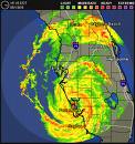
We all tend to think of tropical weather as depressions, storms and hurricanes. However, just a ocean borne cold core low can cause just as much misery. Rainfall totals since this mess began are ranging from 6 to inches on the light side and over 20 inches on the heavy. It just keeps on raining as one band after another is pulled across the state. Not since Fay have rain fall totals come anywhere near what is piling up across Florida. We wanted something tropical to break the drought but I must say no one ever predicted this.
0 likes
-
gatorcane

- S2K Supporter
- Posts: 23708
- Age: 48
- Joined: Sun Mar 13, 2005 3:54 pm
- Location: Boca Raton, FL
Re: Central Florida Rainfall
Downdraft wrote:We wanted something tropical to break the drought but I must say no one ever predicted this.
Actually that is an incorrect statement. The farmer's almanac came very close to predicting this rain event and even predicted above normal rainfall. From the almanac:
April and May will be warmer than normal, with above-normal rainfall. Expect Tropical Storm Ana to threaten Florida in late May, in advance of the official hurricane season
For the curious reader, note the Farmer's almanac prediction for the real hurricane season for Florida.
The summer will be hotter and wetter than normal, with the hottest periods in early and mid-June, mid-July, and mid-August. The hurricane season will be active, with the greatest threats in mid- to late August and early September.
http://www.almanac.com/weatherforecast/us/5
0 likes
-
Downdraft
- S2K Supporter
- Posts: 906
- Joined: Wed Oct 09, 2002 8:45 pm
- Location: Sanford, Florida
- Contact:
Re: Central Florida Rainfall
Well, I stand corrected who would have believed the Farmer's Almanac would have predicted a 20" rain storm. The National Weather Service in Melbourne sure didn't.
0 likes
-
Terry
- S2K Supporter
- Posts: 1450
- Joined: Wed Aug 11, 2004 8:25 pm
- Location: Lakeland and Anna Maria Island, FL
- Contact:
Re: Central Florida Rainfall
We had six inches of rain in south Lakeland last Thursday. And we've had rain almost every day since then. Lucily I'm at the beach on Anna Maria Island and the rain has been scarce.
Feast or famine produces an annual rain "average." It was time for FLA to get clobbered.
Feast or famine produces an annual rain "average." It was time for FLA to get clobbered.
0 likes
Re: Central Florida Rainfall
Terry wrote:We had six inches of rain in south Lakeland last Thursday. And we've had rain almost every day since then. Lucily I'm at the beach on Anna Maria Island and the rain has been scarce.
Feast or famine produces an annual rain "average." It was time for FLA to get clobbered.
Not to be crazy or anything like that, But why would you think it was time for Fla to get
clobbered when we got it last year as well. A lot of people were affected by Fay and now this.
12 inches of water in your front room is no fun at all.
Robjohn53
0 likes
-
southerngale

- Retired Staff

- Posts: 27418
- Joined: Thu Oct 10, 2002 1:27 am
- Location: Southeast Texas (Beaumont area)
Re: Central Florida Rainfall
Robjohn53 wrote:Terry wrote:We had six inches of rain in south Lakeland last Thursday. And we've had rain almost every day since then. Lucily I'm at the beach on Anna Maria Island and the rain has been scarce.
Feast or famine produces an annual rain "average." It was time for FLA to get clobbered.
Not to be crazy or anything like that, But why would you think it was time for Fla to get
clobbered when we got it last year as well. A lot of people were affected by Fay and now this.
12 inches of water in your front room is no fun at all.
Robjohn53
I don't think Terry was saying it was time, as in she wanted it to happen. But it was time for Florida to get clobbered because it's been so dry lately. To get that annual rain "average," you often have very dry periods and very wet periods, hence her comment, "feast or famine." Then it all averages out to the annual rain average.
Sorry to hear about your front room.
0 likes
-
meteorologyman
- Category 2

- Posts: 541
- Joined: Wed Mar 15, 2006 6:48 pm
- Location: Florida, Kissimmee/St.CLoud
Re: Central Florida Rainfall
I'm sure some may not want to here this but more heavy rain is forcasted in Central Florida where some are dealing with floods.
HAZARDOUS WEATHER OUTLOOK
NATIONAL WEATHER SERVICE MELBOURNE FL
445 AM EDT TUE MAY 26 2009
AMZ550-552-555-570-572-575-FLZ041-044>047-053-054-058-059-064-141-
144-147-262000-
COASTAL WATERS FROM FLAGLER BEACH TO VOLUSIA BREVARD COUNTY LINE
OUT 20 NM-
COASTAL WATERS FROM VOLUSIA BREVARD COUNTY LINE TO SEBASTIAN
INLET OUT 20 NM-
COASTAL WATERS FROM SEBASTIAN INLET TO JUPITER INLET OUT 20 NM-
WATERS FROM FLAGLER BEACH TO VOLUSIA BREVARD COUNTY LINE 20 TO
60 NM OFFSHORE-
WATERS FROM VOLUSIA BREVARD COUNTY LINE TO SEBASTIAN INLET 20 TO
60 NM OFFSHORE-
WATERS FROM SEBASTIAN INLET TO JUPITER INLET 20 TO 60 NM OFFSHORE-
INLAND VOLUSIA-NORTHERN LAKE-ORANGE-SEMINOLE-SOUTHERN BREVARD-
OSCEOLA-INDIAN RIVER-OKEECHOBEE-ST. LUCIE-MARTIN-COASTAL VOLUSIA-
SOUTHERN LAKE-NORTHERN BREVARD-
445 AM EDT TUE MAY 26 2009
THIS HAZARDOUS WEATHER OUTLOOK IS FOR EAST CENTRAL FLORIDA.
.DAY ONE...TODAY AND TONIGHT.
...THUNDERSTORM IMPACT...
ATMOSPHERIC MOISTURE...SURFACE HEATING AND SOUTHWEST WINDS ALOFT
WILL COMBINE TO PRODUCE NUMEROUS AFTERNOON LIGHTNING STORMS ACROSS
EAST CENTRAL FLORIDA. STORMS DEVELOPING AT THE GULF COAST LATE THIS
MORNING WILL MOVE INLAND AND EVENTUALLY COMBINE WITH DEVELOPING
STORMS ALONG THE EAST COAST SEA BREEZE BOUNDARY AS IT MOVES INLAND TO
PRODUCE LOCALLY HEAVY RAIN...FREQUENT LIGHTNING AND POSSIBLE SMALL
HAIL BY AFTERNOON. WESTERLY FLOW ALOFT WILL FOCUS STORMS OVER THE
EASTERN PENINSULA BY MID AFTERNOON.
...FLOOD IMPACT...
STRONGER STORMS WILL BE CAPABLE OF PRODUCING 2 TO 3 INCHES OF
RAINFALL WITHIN A COUPLE OF HOURS. GROUNDS SATURATED IN MANY AREAS
DUE TO PREVIOUS RAINFALL WILL EXHIBIT NUISANCE STANDING WATER
CONDITIONS WITH HAZARDOUS DRIVING. THERE IS ALSO A THREAT OF
ADDITIONAL INUNDATION IN FLOOD SENSITIVE AREAS.
...MARINE THUNDERSTORM GUST IMPACT...
STORMS OVER THE MAINLAND WILL BE CAPABLE OF MOVING OFFSHORE THE
INTRACOASTAL WATERS MAINLY FROM FLAGLER BEACH SOUTH TO PORT
CANAVERAL AND SEBASTIAN INLET..PRODUCING FREQUENT LIGHTNING
STRIKES AND WIND GUSTS IN EXCESS OF 34 KNOTS. INLAND LAKES ARE NOT
IMMUNE FROM THE EFFECTS OF STRONG STORMS AND HAZARDOUS BOATING
CONDITIONS CAN QUICKLY DEVELOP OVER LAKES WITH GUSTY WINDS AND
FREQUENT LIGHTNING. BE PREPARED TO SEEK SAFE HARBOR WELL BEFORE A
STORM APPROACHES YOUR AREA.
...RIVER FLOOD IMPACT...
THE SAINT JOHNS RIVER NEAR ASTOR HAS CONTINUED A SLOW
DECREASE SINCE THE WEEKEND. LATEST GAGE READINGS ARE LOWER THAN
MONDAYS READINGS. FORECAST RAINFALL WILL LIKELY KEEP READINGS
ABOVE THE ACTION STAGE
.DAYS TWO THROUGH SEVEN...WEDNESDAY THROUGH MONDAY.
WELL ABOVE AVERAGE RAIN CHANCES WILL CONTINUE THROUGH THE REMAINDER
OF THE WEEK AS ABUNDANT MOISTURE REMAINS OVER THE REGION. THE
POSSIBILITY OF ADDITIONAL HEAVY RAINS OVER ALREADY FLOODED AREAS
WILL CONTINUE ALONG WITH THE TRADITIONAL HAZARDS ASSOCIATED WITH
LIGHTNING STORMS.
.SPOTTER INFORMATION STATEMENT...
SPOTTERS ARE REQUESTED TO MONITOR THE WEATHER AND SELF ACTIVATE
IF NEEDED.
$$
PENDERGRAST
0 likes
-
gigabite

- S2K Supporter
- Posts: 916
- Age: 72
- Joined: Wed May 05, 2004 4:09 pm
- Location: Naples, Florida
Re: Central Florida Rainfall
Downdraft wrote:Well, I stand corrected who would have believed the Farmer's Almanac would have predicted a 20" rain storm. The National Weather Service in Melbourne sure didn't.
The Old Farmers Almanac has a good record of very long range forecasting. I am not sure that the elements that they use, to gauge future rainfall events and cyclone formation, would be considered weather forecasting in today’s terms. The publication has been around since 1792 with a long history of success. The Old Farmers Almanac got Hurricane Andrew right also.
The methods of long range forecasting have changed dramatically over the centuries. Many of what were considered threshold scientific tools of the 18th and early 19th century have been written off as pseudo-science in modern times.
The Saxby Gale is an example of the process and the public reaction to the detailed explanation of it. It is no wonder why the editors keep their process secret.
http://en.wikipedia.org/wiki/1869_Saxby_Gale
0 likes
-
gatorcane
- S2K Supporter
- Posts: 23708
- Age: 48
- Joined: Sun Mar 13, 2005 3:54 pm
- Location: Boca Raton, FL
0 likes
-
meteorologyman
- Category 2
- Posts: 541
- Joined: Wed Mar 15, 2006 6:48 pm
- Location: Florida, Kissimmee/St.CLoud
Re: Central Florida Rainfall
Another Rain maker may be heading for Florida once again From a GOM disturbance where you can gather more info there on the developing system. Due to the fact of most areas seeing 2-4 ft of rain this month I am surprise I have not heard much info about sandbagging. In one month we have almost succeeded the rainfall amount that is typically given in one year. Might as well prepare for it rather than waiting till the rivers about to crest or waiting at last minute.
For example: You notice a river has at least one foot to go before it crest. you figure at the rate rain has fallin and amount that has received there is at least one week left before it's in danger of cresting. If sandbags are placed now rather than a week later damages and lives lost will be less or no loss of life and damage.
Other concerns that might need to be taken into an account.
Has floridians ever practice a hurricane evacuation when numerous roads are flooded. With bunch of detours and road blocks because of flooded roads would probably put people in circles. How can people evacuate in days advance when Major storm is threatening after receiving numerous rainfalls from weak tropical systems.
0 likes
-
floridasun78
- Category 5

- Posts: 3755
- Joined: Sun May 17, 2009 10:16 pm
- Location: miami fl
Re: Central Florida Rainfall
meteorologyman wrote:Another Rain maker may be heading for Florida once again From a GOM disturbance where you can gather more info there on the developing system. Due to the fact of most areas seeing 2-4 ft of rain this month I am surprise I have not heard much info about sandbagging. In one month we have almost succeeded the rainfall amount that is typically given in one year. Might as well prepare for it rather than waiting till the rivers about to crest or waiting at last minute.
For example: You notice a river has at least one foot to go before it crest. you figure at the rate rain has fallin and amount that has received there is at least one week left before it's in danger of cresting. If sandbags are placed now rather than a week later damages and lives lost will be less or no loss of life and damage.
Other concerns that might need to be taken into an account.
Has floridians ever practice a hurricane evacuation when numerous roads are flooded. With bunch of detours and road blocks because of flooded roads would probably put people in circles. How can people evacuate in days advance when Major storm is threatening after receiving numerous rainfalls from weak tropical systems.
what i read from miami weather service gfs out to lunch here what their say HAVE DISCOUNTED THE GFS AS THE LATEST 12Z RUN
(ALONG WITH PREVIOUS RUNS) HAVE BEEN SUFFERING FROM A SEVERE CASE
OF CONVECTIVE FEEDBACK AND SO IS UNRELIABLE. http://forecast.weather.gov/product.php ... glossary=1
0 likes
-
Cane Scared
- Tropical Wave

- Posts: 7
- Joined: Sun Aug 28, 2005 10:53 am
Re: Central Florida Rainfall
gatorcane wrote:Downdraft wrote:We wanted something tropical to break the drought but I must say no one ever predicted this.
Actually that is an incorrect statement. The farmer's almanac came very close to predicting this rain event and even predicted above normal rainfall. From the almanac:
April and May will be warmer than normal, with above-normal rainfall. Expect Tropical Storm Ana to threaten Florida in late May, in advance of the official hurricane season
For the curious reader, note the Farmer's almanac prediction for the real hurricane season for Florida.
The summer will be hotter and wetter than normal, with the hottest periods in early and mid-June, mid-July, and mid-August. The hurricane season will be active, with the greatest threats in mid- to late August and early September.
http://www.almanac.com/weatherforecast/us/5
Thank you for bringing the Farmer's Almanac back into this forum. I mentioned this on a thread before the May storm hit Florida and I was called a 'crazy'. The Almanac also addresses Global Cooling as real, versus that warming crap. The cool/cold fronts just keep coming off the Pacific are still strong enough to transverse the country, that is cooling, not warming. It is June and they keep moving all the way across the country to give us adverse weather. If similar to last year they never really stopped.
0 likes
-
Tampa Bay Hurricane

- Category 5
- Posts: 5597
- Age: 38
- Joined: Fri Jul 22, 2005 7:54 pm
- Location: St. Petersburg, FL
Farmer's Almanac uses Space Weather...because it incorporates the positions
of many planets and uses that to make weather correlations. It can be
accurate to the extent that earth weather correlates with space
weather.
I think the cold fronts sweeping across the nation and the more
active subtropical jet this year with numerous frontal impulses
is most likely due to developing El Nino and warmer tropical
East Pacific waters.
0 likes
Who is online
Users browsing this forum: No registered users and 62 guests