ENSO Updates (2007 thru 2023)

This is the general tropical discussion area. Anyone can take their shot at predicting a storms path.

Moderator: S2k Moderators

Forum rules

The posts in this forum are NOT official forecasts and should not be used as such. They are just the opinion of the poster and may or may not be backed by sound meteorological data. They are NOT endorsed by any professional institution or STORM2K. For official information, please refer to products from the National Hurricane Center and National Weather Service.

Help Support Storm2K
Message
Author
User avatar
cycloneye
Admin
Admin
Posts: 145330
Age: 68
Joined: Thu Oct 10, 2002 10:54 am
Location: San Juan, Puerto Rico

Re: ENSO Updates

#601 Postby cycloneye » Mon Feb 23, 2009 12:30 pm

Below is the latest ENSO forecast by IRI (A Private Firm) It shows mainly Neutral conditions by the summer.

Image

ENSO Update
19 February 2009
Summary
The equatorial Pacific has exhibited weak but clear La Niña conditions since December 2008, and such conditions continue as of mid-February. There is a 55-60% probability of La Niña conditions persisting during the February-April season, decreasing to 30-35% for the April-June season as near-neutral conditions become most likely.

General Discussion

La Niña conditions returned in early December according to the eastern-central Pacific NINO3.4 SST index. Near average conditions had reigned in the tropical Pacific since early June, following the 2007/08 La Niña event. Atmospheric anomalies had suggested that the tropical Pacific should have been cooling since late August 2008, when the Southern Oscillation index became persistently positive, and low-level equatorial winds became persistently easterly. The oceanic response to these atmospheric conditions lagged by three to four months.

Out of a large set of dynamical and statistical forecast models, over half indicate weak La Niña during the coming Feb-Mar-Apr season in progress, but most are trending back towards the neutral range promptly thereafter. Overall, based on model forecasts and current observations of the ocean surface and subsurface, the probability of La Niña conditions is estimated near 60%, of El Niño conditions near 0%, and the probability of maintaining ENSO-neutral conditions is 40% for the Feb-Mar-Apr season in progress. Beginning in Jun-Jul-Aug, no tilt of the climatological odds of 25-50-25% is currently indicated

http://iri.columbia.edu/climate/ENSO/cu ... pdate.html
0 likes   

User avatar
wxman57
Moderator-Pro Met
Moderator-Pro Met
Posts: 22979
Age: 67
Joined: Sat Jun 21, 2003 8:06 pm
Location: Houston, TX (southwest)

Re: ENSO Updates=2/23/09 Update=Neutral thru Summer

#602 Postby wxman57 » Mon Feb 23, 2009 2:48 pm

NCEP ensembles, which last week were forecasting +1C across Nino 3.4 by September are now forecasting only +0.5C for peak season (neutral):
Image
0 likes   

User avatar
cycloneye
Admin
Admin
Posts: 145330
Age: 68
Joined: Thu Oct 10, 2002 10:54 am
Location: San Juan, Puerto Rico

Re: ENSO Updates

#603 Postby cycloneye » Tue Feb 24, 2009 11:21 am

The Southern Occillation Index (SOI) continues to go up now at +16.This is important as the index rises,you can discount El Nino to appear by the Summer months.

Image
0 likes   

User avatar
cycloneye
Admin
Admin
Posts: 145330
Age: 68
Joined: Thu Oct 10, 2002 10:54 am
Location: San Juan, Puerto Rico

Re: ENSO Updates

#604 Postby cycloneye » Fri Feb 27, 2009 5:42 pm

Below is a good graphic of how the Pacific Ocean is behaving in terms of ENSO.This updates every day.I see a lot of blue meaning La Nina is trying to hang on.

Image
0 likes   

User avatar
cycloneye
Admin
Admin
Posts: 145330
Age: 68
Joined: Thu Oct 10, 2002 10:54 am
Location: San Juan, Puerto Rico

Re: ENSO Updates

#605 Postby cycloneye » Mon Mar 02, 2009 6:30 am

Latest ENSO models forecast from Febuary:

Slow Warming of Pacific Temperatures Most Likely in Autumn
Summary
The cool Pacific Ocean sea surface temperatures (SST) and some other aspects of La Niña-like conditions have persisted through February, although most indicators are neutral. The Trade winds in the western Pacific are stronger than normal and the SOI increased in February to a 30-day average value of +15 on 28 February, both indicative of an enhanced Walker circulation. Sub-surface waters are warming across the basin, with weak cool waters in the east but warming water in the west. Our ENSO Wrap-up has more details.

Most international coupled climate models are predicting warming of Pacific Ocean SST in the coming months, but the degree of warming varies widely. One model predicts cool SST to persist until July, three are predicting warming to near-normal values which remain through winter, and two are predicting rapid warming leading to warm conditions consistent with an El Niño by late winter. The spread amongst these outlooks reflects the presence of the "predictability barrier" in ENSO conditions that the climate system displays in the southern autumn and the resultant relatively low forecast skill at present. Taking this uncertainty and the wide-range of predicted outlooks into account, the most likely outcome for the period up to mid-winter is for sea surface temperatures to warm but for them to remain in the neutral range. This outcome is supported by the presence of warm sub-surface waters in the western Pacific Ocean and the decaying cool waters in the east.

http://www.bom.gov.au/climate/ahead/ENSO-summary.shtml
0 likes   

User avatar
cycloneye
Admin
Admin
Posts: 145330
Age: 68
Joined: Thu Oct 10, 2002 10:54 am
Location: San Juan, Puerto Rico

Re: ENSO Updates

#606 Postby cycloneye » Thu Mar 05, 2009 12:56 pm

Climate Prediction Center Latest Update


EL NIÑO/SOUTHERN OSCILLATION (ENSO)
DIAGNOSTIC DISCUSSION
issued by
CLIMATE PREDICTION CENTER/NCEP
5 March 2009

ENSO Alert System Status: La Niña Advisory

Synopsis: La Niña is expected to gradually weaken with increasing chances (greater than 50%) for ENSO-neutral conditions during the Northern Hemisphere Spring.

Atmospheric and oceanic conditions during February 2009 continued to reflect La Niña. Equatorial sea surface temperatures (SST) across the central and east-central Pacific Ocean remained below-average (Fig. 1), but weakened throughout the month. The Niño-4 and Niño-3.4 SST indices also gradually increased, but remained -0.5oC or cooler (Fig. 2). Negative subsurface oceanic heat content anomalies (average temperatures in the upper 300m of the ocean, Fig. 3) and temperature anomalies at thermocline depth also weakened across the eastern half of the Pacific (Fig. 4). However, convection remained suppressed near the Date Line, and enhanced across Indonesia. Also, low-level easterly winds and upper-level westerly winds continued across the equatorial Pacific Ocean. Collectively, these oceanic and atmospheric anomalies are consistent with a weakening La Niña.

While nearly all the model forecasts for the Niño-3.4 region show that La Niña will have dissipated by May – July 2009, the exact timing of the transition to ENSO-neutral conditions is uncertain (Fig. 5). The timing of the expected transition will depend on the strength of the low-level easterly wind anomalies and on how quickly the reservoir of below-average subsurface temperatures dwindles. Therefore, based on current observations, recent trends, and model forecasts, La Niña is expected to gradually weaken with increasing chances (greater than 50%) for ENSO-neutral conditions during the Northern Hemisphere Spring.

Expected La Niña impacts during March-May 2009 include above-average precipitation over Indonesia, and below-average precipitation over the central equatorial Pacific. Compared to the Northern Hemisphere winter, La Niña impacts over the United States are typically less pronounced. For the contiguous United States, potential impacts include below-average precipitation across the southern states. Other potential impacts include below-average temperatures in the Pacific Northwest and above-average temperatures across much of the southwestern and south-central United States.

http://www.cpc.ncep.noaa.gov/products/a ... odisc.html

0 likes   

User avatar
cycloneye
Admin
Admin
Posts: 145330
Age: 68
Joined: Thu Oct 10, 2002 10:54 am
Location: San Juan, Puerto Rico

Re: ENSO Updates

#607 Postby cycloneye » Tue Mar 17, 2009 2:54 pm

It looks like NCEP El Nino 3-4 flattens out by August and September,to then take a little uptick by October.That means if the forecast is right,Neutral ENSO will rule during the heart of the season.

Image
0 likes   

User avatar
cycloneye
Admin
Admin
Posts: 145330
Age: 68
Joined: Thu Oct 10, 2002 10:54 am
Location: San Juan, Puerto Rico

Re: ENSO Updates

#608 Postby cycloneye » Wed Mar 18, 2009 12:00 pm

Below is the latest update of ENSO from the Australians.Neutral conditions for the summer is their forecast: :darrow:

Weak cool SST anomalies have been evident across the central and eastern equatorial Pacific since December 2008. The anomalies weakened slightly across the central equatorial Pacific through February as the sea surface warmed slightly. The monthly NINO indices for February were –0.3°C, –0.6°C and –0.5°C for NINO3, NINO4 and NINO3.4 respectively. When compared to January values, NINO3 and NINO4 were similar in magnitude, while NINO3.4 warmed by approximately 0.3°C.

In terms of weekly data, NINO indices this week were –0.6°C, –0.4°C and –0.5°C for NINO3, NINO4 and NINO3.4 respectively. Over the past three weeks NINO3 has cooled by approximately 0.2°C, while both NINO4 and NINO3.4 warmed. NINO4 warmed the most with an increase of approximately 0.3°C. When compared with three weeks ago the 7-day SST anomaly map shows a weakening of the cool anomalies across the central equatorial Pacific. In contrast, cool anomalies have strengthened slightly in the equatorial eastern Pacific. Warm anomalies have also recently strengthened along the South American west coast. An animation of recent SST changes is available.

A large volume of sub-surface water extending from the central to eastern equatorial Pacific has been anomalously cool since September. Anomalously warm sub-surface water developed in the western equatorial Pacific in December, then propagated eastwards during January and February, thereby warming the central and eastern equatorial Pacific. A recent map for the 5 days ending 9 March shows a large area of sub-surface warm anomalies above +1.0°C extending across the western equatorial Pacific. East of 160°W sub-surface water temperature is generally below average, with anomalies below –1.0°C over a substantual volume. An animation of recent sub-surface changes is available.

An archive of past SST and sub-surface temperature charts is available.

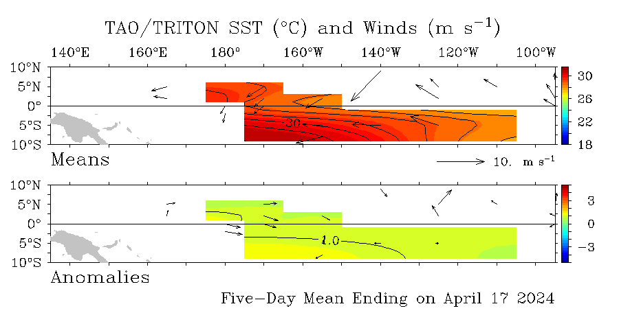
Trade winds remain close to normal across most of the central equatorial Pacific, while stronger than usual Trade winds are still observed across the western equatorial Pacific. Enhanced Trades have also occured over the far eastern equatorial Pacific during recent weeks. The latest weekly wind anomalies are shown in the TAO/TRITON map (small image above) for the five days ending 9 March.

The Southern Oscillation Index (SOI) has been strongly positive since late August. The latest approximate 30-day value for the 9 March is 8. The monthly value for February was +15 (SOI graph, SOI table).

Image

Cloudiness near the date-line over the central to western Pacific is another important indicator of warm/cool ENSO conditions, as it normally increases/decreases (negative OLR/positive OLR anomalies) during these episodes. Cloudiness near the date-line decreased in December, coinciding with cooling of the sea surface in the region. Cloudiness has increased lately, but still remains below average.

The majority of international dynamic computer models surveyed by the Bureau of Meteorology predict a continuation of neutral conditions for the tropical Pacific. Five of the six models are predicting neutral conditions for coming months, while one model predicts La Niña conditions. A minority of models forecast El Niño conditions by late winter, although there is nothing in the current observations to indicate developments in that direction. Therefore, the chances of an El Niño developing during winter are about the same as the long-term or climatological chance. The most likely outcome for the period up to mid-winter is for the sea surface to warm but to remain in the neutral range. Recent forecasts from the POAMA model, run daily at the Bureau of Meteorology, predict ENSO-neutral conditions to persist through to mid-winter.

Image

http://www.bom.gov.au/climate/enso/
0 likes   

User avatar
cycloneye
Admin
Admin
Posts: 145330
Age: 68
Joined: Thu Oct 10, 2002 10:54 am
Location: San Juan, Puerto Rico

Re: ENSO Updates

#609 Postby cycloneye » Thu Mar 19, 2009 1:12 pm

The latest IRI ENSO update for March,which includes all the ENSO Models latest forecasts:

Technical ENSO Update
19 March 2009

Current Conditions

As of mid-March 2009 SSTs are below-average across the central and eastern Pacific. These SSTs, indicative of weak La Niña conditions, developed in early December 2008. They are the result of persistent easterly wind anomalies -- in particular, a large fetch of easterly wind anomalies observed from the central to the west-central Pacific since October 2008, corresponding with both the traditional and equatorial Southern Oscillation Indices (SOI) having been consistently positive. Their affect on the sub-surface ocean structure became notable in November, making for an increasely negative net heat content. During early December the La Niña conditions of the atmosphere finally became evident in the upper ocean as well. However, given the timing of the seasonal cycle, which has passed its coldest months in the eastern Pacific, it appears that La Niña conditions are unlikely to become strong or to endure for multiple consecutive seasons. Such brief cool conditions occurred during the boreal winters of 2000-2001 and also 2005-2006, but even in those two cases the SST crossed into La Niña territory earlier than mid-December.

For February 2009, the SSTs in the NINO3.4 region were more than minimally classifiable as La Niña conditions (-0.69 degrees C anomaly), and for the Dec-Jan-Feb season they were -0.80 degrees C from average. Currently the IRI's definition of El Niño conditions rests on an index of SST anomalies, averaged over the NINO3.4 region (5S-5N; 170W-120W), exceeding the warmest 25%-ile of the historical distribution, and similarly for La Niña relative to the 25%-ile coldest conditions in the historical distribution. The magnitude of NINO3.4 anomaly necessary to qualify as La Niña or El Niño conditions for the Mar-Apr-May and the Apr-May-Jun seasons are approximately 0.40C and 0.40, respectively.


Expected Conditions
The most recent weekly SST anomaly in the NINO3.4 region is -0.4 C, indicating borderline La Niña conditions in the tropical Pacific. What are the probabilities for achieving a La Niña event (i.e. an "event" refers to La Niña conditions persisting for approximately 5 months) in early 2009? Persistent and large-scale easterly wind anomalies along the equator in the western-to-central Pacific have weakened in the last couple weeks. The thermocline, which contitutes the main element of the tropical Pacific system imparting ENSO predictability, is shallow in the eastern part of the Pacific, but deep anomalies in the west loom ready to reverse the current cooling. The shallow thermocline anomalies in the east have already abated considerably since February.

It is possible that the negative anomalies in the east-central Pacific could persist or even strengthen slightly if the low level zonal winds were to increase again in the coming month. However, the winds have actually been weakening recently. Additionally, as the ITCZ moves closer to the equator at this time of year, the Trade Winds will weaken further as the seasonal warming of the eastern Pacific ensues, and it will become more difficult for the atmosphere to maintain cold oceanic conditions. The models, both dynamical and statistical, suggest a tendency towards neutral conditions beginning from the first season.

Currently, the models indicate probabilities of about 50% for La Niña conditions, and very little possbility of developing El Niño conditions for the Mar-Apr-May season in progress. All things considered, during the Mar-Apr-May season there is very nearly an approximate 50-50% split in the probabilities for La Niña and ENSO-neutral conditions, and a near-zero probability for El Niño conditions.


The above assessment was made in part on the basis of an examination of the current forecasts of ENSO prediction models as well as the observed conditions. For purposes of this discussion, El Niño SST conditions are defined as SSTs in the NINO3.4 region being in the warmest 25% of their climatological distribution for the 3-month period in question over the 1950-present timeframe. The corresponding cutoff in terms of degrees C of SST anomaly varies seasonally, being close to 0.40 degrees C in northern late-spring/early-summer season and as high as 0.75 degrees C in late northern autumn. La Niña conditions are defined as NINO3.4 region SSTs being in the coolest 25% of the climatological distribution. Neutral conditions occupy the remaining 50% of the distribution. These definitions were developed such that the most commonly accepted El Niño and La Niña episodes are reproduced.

The models are showing fair agreement in their ENSO forecasts through the 10-month forecast period. For the current Mar-Apr-May season, just under half of the models are predicting La Niña conditions, and the rest predict weakly below-average ENSO-neutral conditions. In fact, throughout 2009, the models favor ENSO-neutral conditions. For the Apr-May-Jun 2009 season, 6 of 22 models (27%) predict La Niña conditions and none predicts El Niño development. At lead times of more than 4 months into the future, statistical and dynamical models that incorporate information about the ocean's observed sub-surface thermal structure generally exhibit higher predictive skill than those that do not. Among models that do use sub-surface temperature information, only 3 of 15 (20%) indicates the existence of La Niña, while 3 of 15 (20%) indicate El Niño conditions for the Jul-Aug-Sep season; 9 of 15 (60%) predict that SSTs will be ENSO-neutral (Note 1). Caution is advised in interpreting the distribution of model forecasts as the actual probabilities. At longer leads, the skill of the models degrades, and skill uncertainty must be convolved with the uncertainties from initial conditions and differing model physics, leading to more climatological probabilities in the long-lead ENSO Outlook than might be suggested by the suite of models. Furthermore, the expected skill of one model versus another has not been established using uniform validation procedures, which may cause a difference in the true probability distribution from that taken verbatim from the raw model predictions.

More analysis below the graphic.

Image

An alternative way to assess the probabilities of the three possible ENSO conditions is to use the mean of the forecasts of all models, and to construct a standard error function centered on that mean. The standard error would be Gaussian in shape, and would have its width determined by an estimate of overall expected model skill for the season of the year and the lead time. Higher skill would result in a relatively narrower error distribution, while low skill would result in an error distribution with width approaching that of the historical observed distribution. This method shows probabilities favoring La Niña near 58% for Mar-Apr-May and 32% for Apr-May-Jun, and favoring ENSO-neutral as being consistently most likely from Apr-May-Jun onward. The same cautions mentioned above for the distribution of model forecasts apply to this alternative method of inferring probabilities, due to differing model biases and skills. In particular, this approach considers only the mean of the predictions, and not the range across the models, nor the ensemble range within individual models.


The IRI's probabilistic ENSO forecast takes into account the indications of this set of models, the outcome of the standard error approach described above, and additional factors such as the very latest observations that may have developed after the initialization times of some of the models. It indicates a 50% probability for La Niña conditions in the Mar-Apr-May season in progress, declining to 32% for Apr-May-Jun, and to 25% by Jun-Jul-Aug and beyond.

http://iri.columbia.edu/climate/ENSO/cu ... nical.html
http://iri.columbia.edu/climate/ENSO/cu ... gure3.html
http://iri.columbia.edu/climate/ENSO/cu ... table.html


0 likes   

User avatar
deltadog03
Professional-Met
Professional-Met
Posts: 3580
Joined: Tue Jul 05, 2005 6:16 pm
Location: Macon, GA

Re: ENSO Updates=3/19/09 IRI latest analysis of ENSO

#610 Postby deltadog03 » Thu Mar 19, 2009 10:27 pm

SOI is tanking.......sounds like nina might be on her last leg.
0 likes   

User avatar
cycloneye
Admin
Admin
Posts: 145330
Age: 68
Joined: Thu Oct 10, 2002 10:54 am
Location: San Juan, Puerto Rico

Re: ENSO Updates=3/19/09 IRI latest analysis of ENSO

#611 Postby cycloneye » Fri Mar 27, 2009 4:31 pm

deltadog03 wrote:SOI is tanking.......sounds like nina might be on her last leg.


Bigtime drop now,almost to 0 after being at +17 in early Febuary.This factor is what has caused me to wait and see if warm ENSO comes by late summer to then decide on my final numbers in the 2009 poll.I would like to see a more tranquil Atlantic season than in past years,but as the old proverbial says,it only takes one.
0 likes   

User avatar
KWT
Category 5
Category 5
Posts: 31415
Joined: Tue Aug 17, 2004 11:02 am
Location: UK!!!

#612 Postby KWT » Fri Mar 27, 2009 6:15 pm

Yep SOI is a good 2 months quicker to come down this year round, I think given the way things are going we will be in weak El Nino by September though there will be a certain amount of lag so I think the season will probably be closed off earlier then normal, no bad thing after Omar and Paloma last season.
0 likes   

HURRICANELONNY
Category 5
Category 5
Posts: 1383
Joined: Wed May 07, 2003 6:48 am
Location: HOLLYWOOD.FL

#613 Postby HURRICANELONNY » Sun Mar 29, 2009 12:03 pm

I hope for El Nino during the heart of Hurricane season. But I think and most models think Neutral. I think the main factor that will keep the #'s down somewhat this year is the SST's. Seems cooler then the last couple of years.

http://www.osdpd.noaa.gov/PSB/EPS/SST/d ... 6.2009.gif

http://www.osdpd.noaa.gov/PSB/EPS/SST/d ... 7.2008.gif
0 likes   

HurricaneBill
Category 5
Category 5
Posts: 3420
Joined: Sun Apr 11, 2004 5:51 pm
Location: East Longmeadow, MA, USA

Re:

#614 Postby HurricaneBill » Sun Mar 29, 2009 5:57 pm

KWT wrote:Yep SOI is a good 2 months quicker to come down this year round, I think given the way things are going we will be in weak El Nino by September though there will be a certain amount of lag so I think the season will probably be closed off earlier then normal, no bad thing after Omar and Paloma last season.


When did the 2004 El Nino start?
0 likes   

User avatar
cycloneye
Admin
Admin
Posts: 145330
Age: 68
Joined: Thu Oct 10, 2002 10:54 am
Location: San Juan, Puerto Rico

Re: ENSO Updates

#615 Postby cycloneye » Mon Mar 30, 2009 8:24 am

The blue colors are waning slowly by the looks of this loop.

Image
0 likes   

User avatar
KWT
Category 5
Category 5
Posts: 31415
Joined: Tue Aug 17, 2004 11:02 am
Location: UK!!!

#616 Postby KWT » Mon Mar 30, 2009 9:10 am

Yep cycloneye should be getting upto the neutral range now I'd imagine, though still no real sign of the warmer el nino waters yet however.
0 likes   

User avatar
cycloneye
Admin
Admin
Posts: 145330
Age: 68
Joined: Thu Oct 10, 2002 10:54 am
Location: San Juan, Puerto Rico

Re: ENSO Updates

#617 Postby cycloneye » Mon Mar 30, 2009 2:42 pm

For those members who may not know what is a Kelvin wave and its relation to El Nino/La Nina as it is mentioned a lot in this thread,at link below is a good explanation with graphics.

http://www.oc.nps.edu/webmodules/ENSO/kelvin.html
0 likes   

User avatar
cycloneye
Admin
Admin
Posts: 145330
Age: 68
Joined: Thu Oct 10, 2002 10:54 am
Location: San Juan, Puerto Rico

Re: ENSO Updates

#618 Postby cycloneye » Wed Apr 01, 2009 8:10 am

Below is the latest update from the Australians about ENSO.They say Neutral conditions are present at this time and may last until mid summer.

Details
The SST across the central and eastern tropical Pacific has slowly warmed through both February and March. When averaged over the month of March, cool SST anomalies persist across the central and eastern equatorial Pacific. However, rapid warming in the recent fortnight has seen these weak anomalies disappear, with the equatorial Pacific SST currently near normal. The monthly NINO indices for March were –0.4°C, –0.3°C and –0.4°C for NINO3, NINO4 and NINO3.4 respectively.

In terms of weekly data, NINO indices this week were –0.1°C, 0.0°C and –0.3°C for NINO3, NINO4 and NINO3.4 respectively. Over the past three weeks all three NINO regions have warmed. NINO3 warmed the most with an increase of approximately 0.5°C, while NINO4 and NINO3.4 warmed by approximately 0.4°C and 0.2°C respectively. When compared with three weeks ago the 7-day SST anomaly map shows most of the equatorial Pacific SSTs are now near normal. The weak cool anomalies that had persisted across the tropical Pacific since late 2008 have warmed to near normal, while positive anomalies in the far east of the Pacific, near South America, strengthened slightly. An animation of recent SST changes is available.

The sub-surface of the equatorial Pacific also warmed through March, however, the sub-surface still remains cooler than the long term average in the central and eastern Pacific. This large volume of anomalously cool sub-surface water in the central and eastern tropical Pacific has persisted since September 2008. A recent map for the 5 days ending 30 March shows a large area of sub-surface warm anomalies above +1.0°C extending across the western equatorial Pacific. East of 150°W sub-surface water temperature is still generally below average, with anomalies below –1.0°C over a substanial volume. An animation of recent sub-surface changes is available.

An archive of past SST and sub-surface temperature charts is available.

Trade winds have weakened through March, with weak anomalous westerly flow now covering most of the tropical Pacific. The latest weekly wind anomalies are shown in the TAO/TRITON map (small image above) for the five days ending 30 March.

The Southern Oscillation Index (SOI) fell sharply through March. The SOI fell from a February value of +15 to a 30-day value of +1 on 30 March. The Tahiti mean sea level pressure (MSLP) fell to near normal during March. Previous to March, the Tahiti MSLP had generally been above average since August 2008. The Darwin MSLP, which was below average for much of February also returned to near normal through March. (SOI graph, SOI table).

Image

Cloudiness near the date-line over the central to western Pacific is another important indicator of warm/cool ENSO conditions, as it normally increases/decreases (negative OLR/positive OLR anomalies) during these episodes. Cloudiness near the date-line decreased in December, coinciding with cooling of the sea surface in the region. Cloudiness increased towards the end of February, but still remains below average.

The majority of international dynamic computer models surveyed by the Bureau of Meteorology predict a continuation of neutral conditions for the tropical Pacific until at least mid-winter. Three of the five models are predicting neutral conditions for winter and spring, while two models predict El Niño conditions to develop. The most likely outcome for the period up to mid-winter is for equatorial Pacific SSTs to warm but to remain in the neutral range. Models suggest a return to La Niña conditions is the least likely outcome. Recent forecasts from the POAMA model, run daily at the Bureau of Meteorology, predict ENSO-neutral conditions to persist through to mid-winter, but for marginal El Niño conditions to develop from mid-winter to spring. Pacific conditions and model predictions will continue to be monitored closely for any strengthening indications of an event.

http://www.bom.gov.au/climate/enso/
0 likes   

User avatar
cycloneye
Admin
Admin
Posts: 145330
Age: 68
Joined: Thu Oct 10, 2002 10:54 am
Location: San Juan, Puerto Rico

Re: ENSO Updates=CPC 4/9/09 Update=Transition to Neutral

#619 Postby cycloneye » Thu Apr 09, 2009 8:48 am

Here is the latest update of ENSO from Climate Prediction Cernter.

Synopsis: A transition to ENSO-neutral conditions is expected during April 2009.

Atmospheric and oceanic conditions during March 2009 continued to reflect weak La Niña conditions. The monthly sea surface temperatures (SST) remain below-average across parts of the east-central and eastern Pacific Ocean (Fig. 1). The Niño-3.4 SST index value persisted near -0.5°C during the month (Fig. 2). Negative subsurface oceanic heat content anomalies (average temperatures in the upper 300m of the ocean, Fig. 3) weakened further across the eastern half of the equatorial Pacific Ocean. At thermocline depth, positive temperature anomalies in the western and central Pacific expanded eastward, while negative temperature anomalies became confined to the far eastern Pacific (Fig. 4). Convection remained suppressed near the Date Line, and enhanced across Indonesia, but weakened during the later part of the month due to Madden-Julian Oscillation (MJO) activity. Enhanced low-level easterly winds and upper-level westerly winds also decreased across the equatorial Pacific Ocean. Collectively, these oceanic and atmospheric anomalies are consistent with a weakening La Niña.

A majority of model forecasts for the Niño-3.4 region show that once ENSO-neutral conditions are reached, it will continue through the remainder of 2009. Several models indicate La Niña will continue through March-May 2009 (Fig. 5). Based on current observations, recent trends, and model forecasts, a transition to ENSO-neutral conditions is expected during April 2009.

Over the equatorial Pacific Ocean, La Niña-like impacts are expected to linger during April-June 2009, including above-average precipitation over Indonesia, and below-average precipitation over the central Pacific. Over the United States, La Niña impacts are strongest during the Northern Hemisphere winter and typically weaken during the spring. During December 2008-February 2009, tropical precipitation anomalies reflected La Niña, characterized by a westward retraction of deep tropical convection towards Indonesia, suppressed precipitation centered on the Date Line, and enhanced rainfall over northeastern South America (Fig. 6). In the United States, La Niña was associated with drier-than-average conditions across the southern tier of states (extending into California and the mid-Atlantic), and wetter-than-average conditions over the Ohio/Tennessee Valleys and northern Intermountain West (Fig. 7).

http://www.cpc.ncep.noaa.gov/products/a ... odisc.html
0 likes   

HURRICANELONNY
Category 5
Category 5
Posts: 1383
Joined: Wed May 07, 2003 6:48 am
Location: HOLLYWOOD.FL

Re: ENSO Updates=CPC 4/9/09 Update=Transition to Neutral

#620 Postby HURRICANELONNY » Thu Apr 09, 2009 12:24 pm

They e-mail that to me to. So why is JB as well as Gray and team saying there could be an El Nino the latter half of Hurricane season? :double:
0 likes   


Return to “Talkin' Tropics”

Who is online

Users browsing this forum: Google [Bot] and 44 guests