BULLETIN - EAS ACTIVATION REQUESTED
SEVERE THUNDERSTORM WARNING
NATIONAL WEATHER SERVICE TULSA OK
958 PM CDT THU MAR 26 2009
THE NATIONAL WEATHER SERVICE IN TULSA HAS ISSUED A
* SEVERE THUNDERSTORM WARNING FOR...
SOUTHERN LATIMER COUNTY IN SOUTHEAST OKLAHOMA
SOUTHWESTERN LE FLORE COUNTY IN SOUTHEAST OKLAHOMA
PUSHMATAHA COUNTY IN SOUTHEAST OKLAHOMA
* UNTIL 1100 PM CDT
* AT 958 PM CDT...NATIONAL WEATHER SERVICE DOPPLER RADAR INDICATED A
LINE OF SEVERE THUNDERSTORMS CAPABLE OF PRODUCING NICKEL SIZE HAIL.
THESE STORMS WERE LOCATED ALONG A LINE EXTENDING FROM KIAMICHI TO
KOSOMA...MOVING NORTHEAST AT 25 MPH.
* SOME LOCATIONS NEAR THE PATH OF THESE STORMS INCLUDE...ALBION...
STANLEY...CLAYTON...KIAMICHI...TUSKAHOMA...TALIHINA AND YANUSH.
Severe Weather - March 25-28 - Mid/Deep South/OH Riv Valley
Moderator: S2k Moderators
Forum rules

The posts in this forum are NOT official forecast and should not be used as such. They are just the opinion of the poster and may or may not be backed by sound meteorological data. They are NOT endorsed by any professional institution or STORM2K.
-
brunota2003

- S2K Supporter

- Posts: 9476
- Age: 35
- Joined: Sat Jul 30, 2005 9:56 pm
- Location: Stanton, KY...formerly Havelock, NC
- Contact:
Re: Severe Weather - March 25-27 - Mid/Deep South
Texas Snowman wrote:Big hail not far away, KXII met Steve LaNore talking about strong rotation developing. Looks like the main threat is Pottsboro, Denison, northern portions of Sherman best as I can tell. We've got about 10 to 15 minutes before it all breaks loose. Getting the family all squared away in our downstairs interior closet under the staircase.
Hope all goes well and everyone stays safe!
0 likes
-
Dave

- Retired Staff

- Posts: 13442
- Age: 75
- Joined: Tue Aug 01, 2006 3:57 pm
- Location: Milan Indiana
- Contact:
GRAYSON TX-
1032 PM CDT THU MAR 26 2009
...A TORNADO WARNING REMAINS IN EFFECT UNTIL 1100 PM CDT FOR EAST
CENTRAL GRAYSON COUNTY...
AT 1029 PM CDT...NATIONAL WEATHER SERVICE METEOROLOGISTS DETECTED A
SEVERE THUNDERSTORM NEAR BELLS...MOVING EAST AT 20 MPH. THIS STORM
HAS THE HISTORY OF LOW LEVEL ROTATION. IN ADDITION TO THE THREAT OF
TORNADOES...THIS STORM IS CAPABLE OF PRODUCING GOLF BALL SIZED HAIL
AND DAMAGING WINDS IN EXCESS OF 60 MPH
THE SEVERE STORM WILL BE NEAR...
BELLS BY 1035 PM CDT...
0 likes
-
Texas Snowman

- Storm2k Moderator

- Posts: 6197
- Joined: Fri Jan 25, 2008 11:29 am
- Location: Denison, Texas
Re: Severe Weather - March 25-27 - Mid/Deep South
We're out of the storm closet, close call, but no hail here, just very heavy rain.
Possible damage near the North Texas Regional Airport, maybe to some mobile homes.
Massive hailstorm in central Grayson County - golfball, baseball, and tennis ball size hail were some things I all heard on local storm reports.
Doug Grace, KXII storm spotter, experienced tennis ball sized hail at 82/1417. Hail covered the road at Hwy. 82/Texoma Pkwy. Circulation passed over Hwy. 82/Texoma Pkwy. while Grace was stationed there. He saw a 100 yard wide tornado with , multiple circling vortices west of Muenster.
Steve LaNore, KXII met, was hard to hear due to the severe noise of hail beating on the KXII studio.
Close call, way too close.
0 likes
-
Dave
- Retired Staff
- Posts: 13442
- Age: 75
- Joined: Tue Aug 01, 2006 3:57 pm
- Location: Milan Indiana
- Contact:
BULLETIN - EAS ACTIVATION REQUESTED
SEVERE THUNDERSTORM WARNING
NATIONAL WEATHER SERVICE FORT WORTH TX
1033 PM CDT THU MAR 26 2009
THE NATIONAL WEATHER SERVICE IN FORT WORTH HAS ISSUED A
* SEVERE THUNDERSTORM WARNING FOR...
NORTHERN FANNIN COUNTY IN NORTH CENTRAL TEXAS...
* UNTIL 1130 PM CDT
* AT 1032 PM CDT...NATIONAL WEATHER SERVICE METEOROLOGISTS DETECTED A
SEVERE THUNDERSTORM CAPABLE OF PRODUCING GOLF BALL SIZE HAIL...AND
DAMAGING WINDS IN EXCESS OF 60 MPH. THIS STORM WAS LOCATED 6 MILES
NORTHWEST OF SAVOY...AND MOVING EAST AT 25 MPH.
* THE SEVERE THUNDERSTORM WILL BE NEAR...
SAVOY BY 1045 PM
ECTOR BY 1100 PM
0 likes


Re: Severe Weather - March 25-27 - Mid/Deep South
Texas Snowman wrote:We're out of the storm closet, close call, but no hail here, just very heavy rain.
Possible damage near the North Texas Regional Airport, maybe to some mobile homes.
Massive hailstorm in central Grayson County - golfball, baseball, and tennis ball size hail were some things I all heard on local storm reports.
Doug Grace, KXII storm spotter, experienced tennis ball sized hail at 82/1417. Hail covered the road at Hwy. 82/Texoma Pkwy. Circulation passed over Hwy. 82/Texoma Pkwy. while Grace was stationed there. He saw a 100 yard wide tornado with , multiple circling vortices west of Muenster.
Steve LaNore, KXII met, was hard to hear due to the severe noise of hail beating on the KXII studio.
Close call, way too close.
I saw 3,75 " hail. Well, that could kill a pig
0 likes
-
Texas Snowman
- Storm2k Moderator
- Posts: 6197
- Joined: Fri Jan 25, 2008 11:29 am
- Location: Denison, Texas
Re: Severe Weather - March 25-27 - Mid/Deep South
Bunkertor wrote:Texas Snowman wrote:We're out of the storm closet, close call, but no hail here, just very heavy rain.
Possible damage near the North Texas Regional Airport, maybe to some mobile homes.
Massive hailstorm in central Grayson County - golfball, baseball, and tennis ball size hail were some things I all heard on local storm reports.
Doug Grace, KXII storm spotter, experienced tennis ball sized hail at 82/1417. Hail covered the road at Hwy. 82/Texoma Pkwy. Circulation passed over Hwy. 82/Texoma Pkwy. while Grace was stationed there. He saw a 100 yard wide tornado with , multiple circling vortices west of Muenster.
Steve LaNore, KXII met, was hard to hear due to the severe noise of hail beating on the KXII studio.
Close call, way too close.
I saw 3,75 " hail. Well, that could kill a pig
Guarantee it - I would guess there is significant hail damage in Sherman. Best I can tell, worst of the hail was about 3-5 miles south of my house. We never got one hail stone and it was covering the ground not too far away.
I don't mind admitting that was the most concerned I have ever been on an approaching storm. A pronounced hook echo on the local KXII dop-radar bearing down on our house and reports of baseball and bigger hail. Watching that hook come at you, pretty helpless feeling.
BTW, I think I'll take a cup of coffee now!
0 likes


-
Texas Snowman
- Storm2k Moderator
- Posts: 6197
- Joined: Fri Jan 25, 2008 11:29 am
- Location: Denison, Texas
Re: Severe Weather - March 25-27 - Mid/Deep South
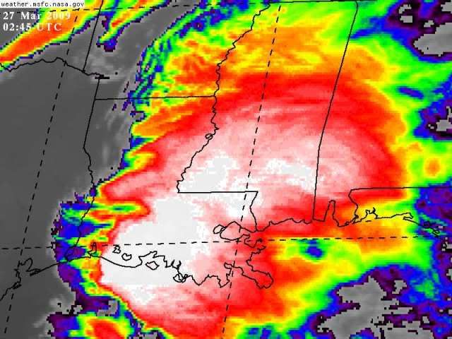
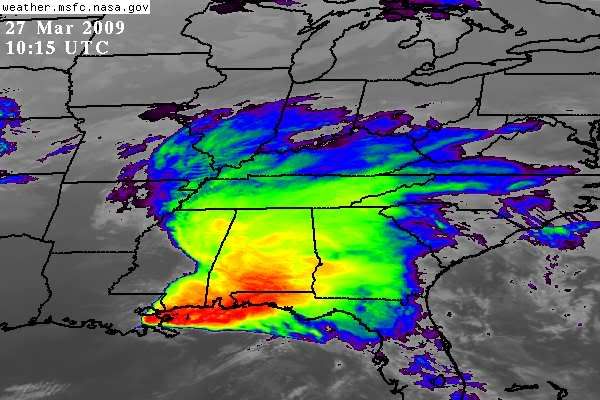
Wow - what tropical storm is that?!  Impressive looking complex of storms!
0 likes
WFUS54 KLIX 270351
TORLIX
LAC005-007-063-093-095-270415-
/O.NEW.KLIX.TO.W.0006.090327T0351Z-090327T0415Z/
BULLETIN - EAS ACTIVATION REQUESTED
TORNADO WARNING
NATIONAL WEATHER SERVICE NEW ORLEANS LA
1051 PM CDT THU MAR 26 2009
THE NATIONAL WEATHER SERVICE IN NEW ORLEANS HAS ISSUED A
* TORNADO WARNING FOR...
EAST CENTRAL ASCENSION PARISH IN SOUTHEAST LOUISIANA...
EAST CENTRAL ASSUMPTION PARISH IN SOUTHEAST LOUISIANA...
SOUTH CENTRAL LIVINGSTON PARISH IN SOUTHEAST LOUISIANA...
ST. JAMES PARISH IN SOUTHEAST LOUISIANA...
NORTHWESTERN ST. JOHN THE BAPTIST PARISH IN SOUTHEAST LOUISIANA...
* UNTIL 1115 PM CDT
* AT 1049 PM CDT...NATIONAL WEATHER SERVICE DOPPLER RADAR INDICATED A
SEVERE THUNDERSTORM CAPABLE OF PRODUCING A TORNADO NEAR CONVENT...
OR 10 MILES EAST OF NAPOLEONVILLE...MOVING NORTHEAST AT 45 MPH.
* THE TORNADO WILL BE NEAR...
LUTCHER AND 6 MILES NORTHWEST OF GRAMERCY BY 1100 PM CDT...
WHITEHALL BY 1115 PM CDT...
0 likes
-
somethingfunny

- ChatStaff

- Posts: 3926
- Age: 37
- Joined: Thu May 31, 2007 10:30 pm
- Location: McKinney, Texas
Re: Severe Weather - March 25-27 - Mid/Deep South
Texas Snowman wrote:Bunkertor wrote:Texas Snowman wrote:We're out of the storm closet, close call, but no hail here, just very heavy rain.
Possible damage near the North Texas Regional Airport, maybe to some mobile homes.
Massive hailstorm in central Grayson County - golfball, baseball, and tennis ball size hail were some things I all heard on local storm reports.
Doug Grace, KXII storm spotter, experienced tennis ball sized hail at 82/1417. Hail covered the road at Hwy. 82/Texoma Pkwy. Circulation passed over Hwy. 82/Texoma Pkwy. while Grace was stationed there. He saw a 100 yard wide tornado with , multiple circling vortices west of Muenster.
Steve LaNore, KXII met, was hard to hear due to the severe noise of hail beating on the KXII studio.
Close call, way too close.
I saw 3,75 " hail. Well, that could kill a pig
Guarantee it - I would guess there is significant hail damage in Sherman. Best I can tell, worst of the hail was about 3-5 miles south of my house. We never got one hail stone and it was covering the ground not too far away.
I don't mind admitting that was the most concerned I have ever been on an approaching storm. A pronounced hook echo on the local KXII dop-radar bearing down on our house and reports of baseball and bigger hail. Watching that hook come at you, pretty helpless feeling.
BTW, I think I'll take a cup of coffee now!
I was at work through that whole thing. We closed early due to weather...I was upset because I need the extra money right now.
Everybody's phones, even the store phone, were ringing, as people relayed info on the tornado warning to everyone they know....since Denison still hasn't fixed the storm sirens.
Aside from heavy rain and frequent lightning, we did briefly see pea-sized hail falling, but aside from that nothing. We were actually under two tornado warnings at the same time....from what I understand, the southern one was more intense as it crossed US 75. Everything out here in Pottsboro where I live, seems to be in fine order.
Bring on round two tomorrow!
0 likes

Downgraded from MDT to SLGT
DAY 1 CONVECTIVE OUTLOOK
NWS STORM PREDICTION CENTER NORMAN OK
1258 AM CDT FRI MAR 27 2009
....
IT IS IMPORTANT TO NOT FOCUS SOLELY ON THE DOWNGRADE OF THE
CATEGORICAL RISK TO SLGT AS THE INITIAL DAY 1 FCST WILL CONTAIN
MODEST SVR PROBABILITIES/STRONG SLGT RISK. SUBSEQUENT OTLKS ON
FRIDAY MAY VERY WELL NEED TO INCREASE THE SVR PROBABILITIES/UPGRADE
TO MDT RISK ONCE THE EFFECTS OF MORNING GULF COAST MCS CAN BE BETTER
ASSESSED.
..RACY/HURLBUT.. 03/27/2009
0 likes


 [/img]
Return to “USA & Caribbean Weather”
Who is online
Users browsing this forum: No registered users and 125 guests