Tornado outbreak - February 10-11, 8+ dead
Moderator: S2k Moderators
Forum rules

The posts in this forum are NOT official forecast and should not be used as such. They are just the opinion of the poster and may or may not be backed by sound meteorological data. They are NOT endorsed by any professional institution or STORM2K.

-
CrazyC83
- Professional-Met

- Posts: 34315
- Joined: Tue Mar 07, 2006 11:57 pm
- Location: Deep South, for the first time!
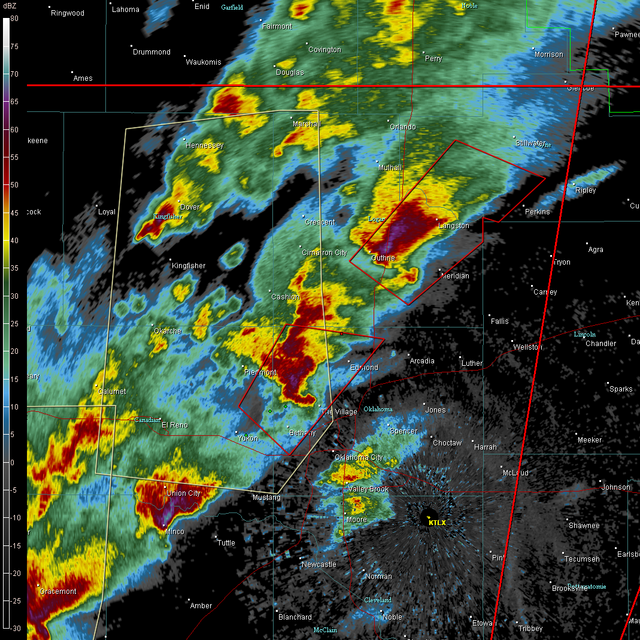
Second storm (Supercell B): starting to lower. Tornado warning issued.
First storm (Supercell A): on a dead track towards Stillwater if it stays on track in the next 45 minutes or so.
First storm (Supercell A): on a dead track towards Stillwater if it stays on track in the next 45 minutes or so.
Last edited by CrazyC83 on Tue Feb 10, 2009 4:09 pm, edited 1 time in total.
0 likes
BULLETIN - EAS ACTIVATION REQUESTED
TORNADO WARNING
NATIONAL WEATHER SERVICE NORMAN OK
308 PM CST TUE FEB 10 2009
THE NATIONAL WEATHER SERVICE IN NORMAN HAS ISSUED A
* TORNADO WARNING FOR...
EASTERN CANADIAN COUNTY IN CENTRAL OKLAHOMA...
NORTHWESTERN OKLAHOMA COUNTY IN CENTRAL OKLAHOMA...
* UNTIL 345 PM CST
* AT 308 PM CST...NATIONAL WEATHER SERVICE DOPPLER RADAR INDICATED A
SEVERE THUNDERSTORM CAPABLE OF PRODUCING A TORNADO OVER WESTERN
OKLAHOMA CITY...3 MILES SOUTH OF YUKON...MOVING NORTHEAST AT 45
MPH.
* LOCATIONS IN THE WARNING INCLUDE BETHANY...NICHOLS HILLS...
NORTHWESTERN OKLAHOMA CITY...THE VILLAGE...WARR ACRES...WESTERN
EDMOND AND YUKON.
New tor on 2nd cell.
0 likes


-
somethingfunny

- ChatStaff

- Posts: 3926
- Age: 37
- Joined: Thu May 31, 2007 10:30 pm
- Location: McKinney, Texas
-
Texas Snowman

- Storm2k Moderator

- Posts: 6197
- Joined: Fri Jan 25, 2008 11:29 am
- Location: Denison, Texas
Re: Tornado outbreak? February 10-11, Plains/Midwest/South
Yes.
Hopefully they will not be needed tonight.
Two tornado strikes in as many months would be a bit much, don't you think?
Hopefully they will not be needed tonight.
Two tornado strikes in as many months would be a bit much, don't you think?
0 likes
-
Texas Snowman
- Storm2k Moderator
- Posts: 6197
- Joined: Fri Jan 25, 2008 11:29 am
- Location: Denison, Texas
Re: Tornado outbreak? February 10-11, Plains/Midwest/South
KOCO: lowering nearly to ground in OKC with second storm
KOCO: Tornado warning now up for Gutherie area
KOCO: Tornado warning now up for Gutherie area
0 likes


Re:
RL3AO wrote:Expect a new TOR for Southern Canadian Co any minute.
BULLETIN - EAS ACTIVATION REQUESTED
TORNADO WARNING
NATIONAL WEATHER SERVICE NORMAN OK
332 PM CST TUE FEB 10 2009
THE NATIONAL WEATHER SERVICE IN NORMAN HAS ISSUED A
* TORNADO WARNING FOR...
EASTERN CANADIAN COUNTY IN CENTRAL OKLAHOMA...
* UNTIL 400 PM CST
* AT 332 PM CST...DOPPLER RADAR AND STORM SPOTTERS OBSERVED A TORNADO
10 MILES SOUTHWEST OF YUKON...MOVING NORTHEAST AT 45 MPH.
* LOCATIONS IN THE WARNING INCLUDE NORTHWESTERN OKLAHOMA CITY...
PIEDMONT...RICHLAND AND YUKON.
0 likes
Return to “USA & Caribbean Weather”
Who is online
Users browsing this forum: No registered users and 114 guests