
2008-09 Texas Winter Weather Thread
Moderator: S2k Moderators
Forum rules
 The posts in this forum are NOT official forecast and should not be used as such. They are just the opinion of the poster and may or may not be backed by sound meteorological data. They are NOT endorsed by any professional institution or STORM2K.

The posts in this forum are NOT official forecast and should not be used as such. They are just the opinion of the poster and may or may not be backed by sound meteorological data. They are NOT endorsed by any professional institution or STORM2K.
-
Ed Mahmoud
Re: 2008-09 Texas Winter Weather Thread
The new GFS is giving me a tingle up my legs, with a genuine major ice storm for DFW, over half an inch of ice!
0 likes

Re: 2008-09 Texas Winter Weather Thread
That's good and bad news for me, I want the ice storm, I just don't want to lose power or anything. I'll be crossing my fingers maybe by some miracle it'll all change to snow.
0 likes
-
srainhoutx

- S2K Supporter

- Posts: 6919
- Age: 68
- Joined: Sun Jan 14, 2007 11:34 am
- Location: Haywood County, NC
- Contact:
Re: 2008-09 Texas Winter Weather Thread
Interesting Updates coming in tonight across TX as the air behind the front is much colder than progged. MAF just hoisted a WWA due to the dramatic temp drop post FROPA and overunning issues. Although the boundry has slowed a bit this afternoon/evening, a surface low appears to be forming in the Rio Grande Valley. Cold air should continue to spill S to our W into the Hill Country later tonight and then increase in foward speed. This is a very dense and shallow airmass (only 1200 ft per LUB). 00Z NAM and GFS show some heafty QPF for tomorrow afternoon/night for areas to our N and points E. Looks as if a lot of TX other than coastal regions will have some issues to deal with. Another point is that Tulsa and points E have reported Thunderstorms with heavy icing. This will now doubt be a big trouble maker for many parts of the country the next couple of days.
SPECIAL WEATHER STATEMENT
NATIONAL WEATHER SERVICE AUSTIN/SAN ANTONIO TX
1111 PM CST MON JAN 26 2009
TXZ171>173-183>194-202>209-217>225-228-271200-
LLANO-BURNET-WILLIAMSON-VAL VERDE-EDWARDS-REAL-KERR-BANDERA-
GILLESPIE-KENDALL-BLANCO-HAYS-TRAVIS-BASTROP-LEE-KINNEY-UVALDE-
MEDINA-BEXAR-COMAL-GUADALUPE-CALDWELL-FAYETTE-MAVERICK-ZAVALA-
FRIO-ATASCOSA-WILSON-KARNES-GONZALES-DE WITT-LAVACA-DIMMIT-
INCLUDING THE CITIES OF...LLANO...BURNET...GEORGETOWN...DEL RIO...
ROCKSPRINGS...LEAKEY...KERRVILLE...BANDERA...FREDERICKSBURG...
BOERNE...BLANCO...SAN MARCOS...AUSTIN...BASTROP...GIDDINGS...
BRACKETTVILLE...UVALDE...HONDO...SAN ANTONIO...NEW BRAUNFELS...
SEGUIN...LOCKHART...LA GRANGE...EAGLE PASS...CRYSTAL CITY...
PEARSALL...PLEASANTON...FLORESVILLE...KARNES CITY...GONZALES...
CUERO...HALLETTSVILLE...CARRIZO SPRINGS
1111 PM CST MON JAN 26 2009
...WINTER WEATHER POSSIBLE ACROSS PARTS OF SOUTH CENTRAL TEXAS
TUESDAY INTO EARLY WEDNESDAY...
A STRONG COLD FRONT WILL MOVE ACROSS SOUTH CENTRAL TEXAS LATER
TONIGHT AND TUESDAY. HIGH TEMPERATURES FOR TUESDAY WILL BE REACHED
IN THE EARLY TO MID MORNING HOURS...THEN TEMPERATURES WILL FALL
THE REMAINDER OF THE DAY.
PATCHY LIGHT RAIN IS EXPECTED ON TUESDAY. TEMPERATURES WILL FALL
TO SLIGHTLY BELOW FREEZING ACROSS PARTS OF THE HILL COUNTRY
DURING THE AFTERNOON. A WINTER WEATHER ADVISORY HAS BEEN ISSUED
FROM NOON CST TO 6 PM CST TUESDAY FOR BANDERA...BLANCO...
BURNET...EDWARDS...GILLESPIE...KENDALL...KERR...LLANO...AND REAL
COUNTIES. THERE IS THREAT OF MINOR ACCUMULATIONS OF ICE MAINLY ON
BRIDGES AND OVERPASSES TUESDAY AFTERNOON.
A STRONG UPPER LEVEL DISTURBANCE WILL MOVE OVER THE COLD AIR AT
THE SURFACE TO PRODUCE A MIX OF PRECIPITATION TUESDAY NIGHT INTO
WEDNESDAY MORNING. THERE IS A THREAT FOR MORE WIDESPREAD FREEZING
RAIN AND SLEET WITH GREATER ICE ACCUMULATIONS AS TEMPERATURES
BELOW FREEZING SPREAD TO A LARGER AREA OF SOUTH CENTRAL TEXAS.
THIS THREAT IS ALONG AND NORTH OF A DEL RIO TO BOERNE TO GIDDINGS
LINE. A WINTER STORM WATCH CONTINUES IN EFFECT FROM 6 PM CST
TUESDAY EVENING UNTIL TO 11 AM CST WEDNESDAY MORNING FOR
BANDERA...BASTROP...BLANCO...BURNET...COMAL...EDWARDS...
GILLESPIE...HAYS...KENDALL...KERR...LEE...LLANO...REAL...
TRAVIS...VAL VERDE...AND WILLIAMSON...COUNTIES. ICE ACCUMULATIONS
WILL MAINLY BE AROUND ONE TENTH INCH...ALTHOUGH UP TO ONE QUARTER
INCH IS POSSIBLE IN A FEW SPOTS.
ELSEWHERE...A COLD RAIN CAN BE EXPECTED WITH RAINFALL AMOUNTS
GENERALLY BE LESS THAN ONE QUARTER OF AN INCH. A BRIEF PERIOD OF
LIGHT SLEET IS POSSIBLE AS THE PRECIPITATION ENDS WEDNESDAY
MORNING...HOWEVER NO ICE ACCUMULATIONS ARE EXPECTED.
THE PRECIPITATION WILL END FROM WEST TO WEST WEDNESDAY MORNING.
WARMER TEMPERATURES BY AFTERNOON WILL MELT ANY ICE ACCUMULATIONS.
0 likes
-
somethingfunny

- ChatStaff

- Posts: 3926
- Age: 37
- Joined: Thu May 31, 2007 10:30 pm
- Location: McKinney, Texas
I'll never understand why the NWS tends to report "Unknown precip" when the temperature hits freezing. Similarly, how can rain be "mixed" with freezing rain? THEY'RE THE SAME THING!
For instance, the temperature right now might be 32°, but I am reporting that 'unknown precipitation' to in fact be a steady drizzle. And nothing is iced over as of yet; just wet.
For instance, the temperature right now might be 32°, but I am reporting that 'unknown precipitation' to in fact be a steady drizzle. And nothing is iced over as of yet; just wet.
0 likes
-
CajunMama
- Retired Staff

- Posts: 10791
- Joined: Thu Feb 06, 2003 9:57 pm
- Location: 30.22N, 92.05W Lafayette, LA
Just a reminder to those posting graphics....please include a short explanation of what you are focusing on in the graph. Not everyone understands the graphs and you'd be helping to teach someone who has a beginning interest in weather. Please remember to do this in all weather forums. Thanks!
0 likes
-
somethingfunny
- ChatStaff
- Posts: 3926
- Age: 37
- Joined: Thu May 31, 2007 10:30 pm
- Location: McKinney, Texas
Re: 2008-09 Texas Winter Weather Thread
I am sitting here anxiously awaiting to find out if school's been cancelled or not. Very anxiously. 
0 likes
-
cheezyWXguy

- Category 5

- Posts: 6282
- Joined: Mon Feb 13, 2006 12:29 am
- Location: Dallas, TX
Re: 2008-09 Texas Winter Weather Thread
somethingfunny wrote:I am sitting here anxiously awaiting to find out if school's been cancelled or not. Very anxiously.
I wish the would even though the sufficient .25 inch of ice hasnt yet accumulated. If school goes on today, getting out of school is going to be treacherous this afternoon
0 likes
-
Portastorm

- Storm2k Moderator

- Posts: 9955
- Age: 63
- Joined: Fri Jul 11, 2003 9:16 am
- Location: Round Rock, TX
- Contact:
Re: 2008-09 Texas Winter Weather Thread
Austin area now under a Winter Storm WARNING for tonight and tomorrow morning for freezing rain. Up to .25 inch possible by the time the sun comes out later tomorrow. We shall see.
Portastorm places his kicking shoes by the front door and believes he now hears Lucy calling him outside.
Edit update at 6 am: The front appears to be knocking on our front door. Mid 60s here in the Austin metro but winds have shifted to the north and temps now dropping in Cedar Park/Round Rock areas.
0 likes
-
Ed Mahmoud
Re: 2008-09 Texas Winter Weather Thread
"Unknown precip" means the automated weather station can't tell what is falling.
Joe Bastardi misses the days when they had live weather observers everywhere, of course, ASOS doesn't demand union scale, health benefits and 2 weeks of vacation every year.
Joe Bastardi misses the days when they had live weather observers everywhere, of course, ASOS doesn't demand union scale, health benefits and 2 weeks of vacation every year.
0 likes
-
gboudx

- S2K Supporter
- Posts: 4090
- Joined: Thu Sep 04, 2003 1:39 pm
- Location: Rockwall, Tx but from Harvey, La
Morning update from Jeff Lindner. Be careful if you have to drive. As it turns out, I have to go into work for a couple hours. Hopefully this holds off until about noon for the Plano/Richardson/Wylie/Rockwall area.
Ice Storm Warning remains in effect for most of N TX.
Major winter weather event to begin shortly and last through early Wednesday. Significant amounts of icing are expected.
Very cold arctic air mass invading N TX with temps. falling through the mid 30’s toward freezing at many locations. Will see the freezing line progress through most of N TX by early evening. Approaching trough over the 4 corners will induce overrunning above the cold dome resulting in a 24 hour period of rainfall. As surface temps. fall below freezing the rain will become freezing rain and as the cold air deepens sleet will mix in with the freezing rain. Should see the onset of freezing rain by midday across most of the metro…maybe sooner given FTW is already at 32. Icing of bridges and overpasses will be likely by this afternoon and then surface streets after dark.
Ice accumulations of .25 to .5 of an inch is possible resulting in nearly impossible travel and dangerous air travel. Expect long delays and flight cancellations at area airports as planes will require rigorous de-icing operations. Icing of this magnitude will also result in some power outages and downed tree limbs.
Temps. should recover above freezing by midday Thursday resulting in melting.
0 likes
-
srainhoutx
- S2K Supporter
- Posts: 6919
- Age: 68
- Joined: Sun Jan 14, 2007 11:34 am
- Location: Haywood County, NC
- Contact:
Re: 2008-09 Texas Winter Weather Thread
Stay Safe everyone and Stay Informed. My thoughts are with you. SE TX looks to escape the worst of this event, but a Winter Storm Watch has been issued for Northern CWA...
URGENT - WINTER WEATHER MESSAGE
NATIONAL WEATHER SERVICE HOUSTON/GALVESTON TX
500 AM CST TUE JAN 27 2009
...A WINTER STORM WATCH IS IN EFFECT FOR NORTHERN PORTIONS OF
SOUTHEAST TEXAS FOR FREEZING RAIN...
.FREEZING RAIN MAY DEVELOP MAINLY NORTH OF A LINE FROM BRENHAM TO
GROVETON AFTER MIDNIGHT THROUGH WEDNESDAY MORNING. A COLD FRONT
IS EXPECTED TO PUSH THROUGH THE AREA TODAY USHERING IN A MUCH
COLDER AIRMASS. TEMPERATURES BELOW FREEZING ARE EXPECTED TO
DEVELOP IN THE WATCH AREA WEDNESDAY MORNING. RAIN WILL BE
POSSIBLE AS AN UPPER LEVEL DISTURBANCE MOVES ACROSS THE AREA AND
THE RAIN WILL FREEZE WHEN IN CONTACT WITH SURFACES BELOW
FREEZING. ICE ACCUMULATIONS MAY BE AS MUCH AS A TENTH OF AN INCH.
THE MAIN UNCERTAINTY WILL BE WHETHER FREEZING TEMPERATURES
DEVELOP AS THE FREEZING LINE MAY SET UP JUST NORTH OF THE WATCH
AREA BUT IS EXPECTED TO PUSH SOUTH OF THE WATCH AREA. TRAVEL
CONDITIONS ON AREA ROADS WILL BE HAZARDOUS SHOULD FREEZING RAIN
DEVELOP ESPECIALLY ON EXPOSED BRIDGES AND OVERPASSES. TREES AND
POWER POLES MAY ALSO BE SUSCEPTIBLE TO ICING. RESIDENTS OF
SOUTHEAST TEXAS IN THE WATCH AREA ARE ENCOURAGED TO MONITOR THE
FORECAST FOR FURTHER UPDATES AND FOR POSSIBLE WARNINGS AND
ADVISORIES.
TXZ163-164-176-177-195>198-272100-
/O.NEW.KHGX.WS.A.0001.090128T0600Z-090128T1500Z/
BRAZOS-BURLESON-GRIMES-HOUSTON-MADISON-TRINITY-WALKER-WASHINGTON-
INCLUDING THE CITIES OF...BRENHAM...BRYAN...CALDWELL...
COLLEGE STATION...CROCKETT...GROVETON...HUNTSVILLE...
LAKE SOMERVILLE...MADISONVILLE...NAVASOTA...TRINITY
500 AM CST TUE JAN 27 2009
...WINTER STORM WATCH IN EFFECT FROM LATE TONIGHT THROUGH
WEDNESDAY MORNING...
THE NATIONAL WEATHER SERVICE IN HOUSTON/GALVESTON HAS ISSUED A
WINTER STORM WATCH...WHICH IS IN EFFECT FROM LATE TONIGHT THROUGH
WEDNESDAY MORNING.
FREEZING RAIN MAY DEVELOP MAINLY NORTH OF A LINE FROM BRENHAM TO
GROVETON AFTER MIDNIGHT THROUGH WEDNESDAY MORNING. A COLD FRONT
IS EXPECTED TO PUSH THROUGH THE AREA TODAY USHERING IN A MUCH
COLDER AIRMASS. TEMPERATURES BELOW FREEZING ARE EXPECTED TO
DEVELOP IN THE WATCH AREA WEDNESDAY MORNING. RAIN WILL BE
POSSIBLE AS AN UPPER LEVEL DISTURBANCE MOVES ACROSS THE AREA AND
THE RAIN WILL FREEZE WHEN IN CONTACT WITH SURFACES BELOW
FREEZING. ICE ACCUMULATIONS MAY BE AS MUCH AS A TENTH OF AN INCH.
THE MAIN UNCERTAINTY WILL BE WHETHER FREEZING TEMPERATURES
DEVELOP AS THE FREEZING LINE MAY SET UP JUST NORTH OF THE WATCH
AREA BUT IS EXPECTED TO PUSH SOUTH OF THE WATCH AREA. TRAVEL
CONDITIONS ON AREA ROADS WILL BE HAZARDOUS SHOULD FREEZING RAIN
DEVELOP ESPECIALLY ON EXPOSED BRIDGES AND OVERPASSES. TREES AND
POWER POLES MAY ALSO BE SUSCEPTIBLE TO ICING. RESIDENTS OF
SOUTHEAST TEXAS IN THE WATCH AREA ARE ENCOURAGED TO MONITOR THE
FORECAST FOR FURTHER UPDATES AND FOR POSSIBLE WARNINGS AND
ADVISORIES.
A WINTER STORM WATCH MEANS THERE IS A POTENTIAL FOR SIGNIFICANT
SNOW...SLEET...OR ICE ACCUMULATIONS THAT MAY IMPACT TRAVEL.
CONTINUE TO MONITOR THE LATEST FORECASTS.
ROADS...BRIDGES...AND OVERPASSES IN THE WATCH AREA MAY BECOME
SLICK AND HAZARDOUS. ACCUMULATION OF SNOW OR ICE ON
ROADWAYS...BRIDGES AND OVERPASSES MAY MAKE TRAVEL TREACHEROUS.
EXERCISE CAUTION IF TRAVEL IS NECESSARY.
0 likes
-
CaptinCrunch

- S2K Supporter
- Posts: 8784
- Age: 58
- Joined: Mon Nov 03, 2003 4:33 pm
- Location: Kennedale, TX (Tarrant Co.)
Ice accumulations of .25 to .5 of an inch is possible resulting in nearly impossible travel and dangerous air travel?
Well that will depend on where you live at in NTX, if you live in the D/FW metro area you can expect between .10 to .40, If you live to the NE (N of I-30)you can expect .25 to .75, and if you live to the N and NW (N of of I-20) you can expect lotts of sleet mixed in with the FR which will result in .33 to .65
But most of the freezing rain wont happen till late afternoon and over night for the D/FW metro area.
Last edited by CaptinCrunch on Tue Jan 27, 2009 8:59 am, edited 1 time in total.
0 likes
-
somethingfunny
- ChatStaff
- Posts: 3926
- Age: 37
- Joined: Thu May 31, 2007 10:30 pm
- Location: McKinney, Texas
The freeze has finally pushed through Grayson County. There's a very light glaze on the railings, trees, and cars. But nothing falling from the sky currently. Give the grass and the streets some time to freeze up...and then everything that falls after that is going to result in net accumulations. 
0 likes
-
CaptinCrunch
- S2K Supporter
- Posts: 8784
- Age: 58
- Joined: Mon Nov 03, 2003 4:33 pm
- Location: Kennedale, TX (Tarrant Co.)
Re:
somethingfunny wrote:The freeze has finally pushed through Grayson County. There's a very light glaze on the railings, trees, and cars. But nothing falling from the sky currently. Give the grass and the streets some time to freeze up...and then everything that falls after that is going to result in net accumulations.
aye, and Grayson County falls under the ...WINTER STORM WARNING REMAINS IN EFFECT UNTIL 6 AM CST
WEDNESDAY...
0 likes
-
somethingfunny
- ChatStaff
- Posts: 3926
- Age: 37
- Joined: Thu May 31, 2007 10:30 pm
- Location: McKinney, Texas
Re: Re:
CaptinCrunch wrote:somethingfunny wrote:The freeze has finally pushed through Grayson County. There's a very light glaze on the railings, trees, and cars. But nothing falling from the sky currently. Give the grass and the streets some time to freeze up...and then everything that falls after that is going to result in net accumulations.
aye, and Grayson County falls under the ...WINTER STORM WARNING REMAINS IN EFFECT UNTIL 6 AM CST
WEDNESDAY...
Yep. They cancelled our Ice Storm Warning for this county alone. Here's to hoping that means a heavy snow band is expected to setup right about here!

0 likes
-
jasons2k

- Storm2k Executive

- Posts: 8290
- Age: 52
- Joined: Wed Jul 06, 2005 12:32 pm
- Location: The Woodlands, TX
Re:
somethingfunny wrote: Similarly, how can rain be "mixed" with freezing rain? THEY'RE THE SAME THING!
There are a few reasons for this:
1) 32F is the freezing point of water but it is also the melting point for ice. Harold Taft used to always point out that 2nd part because most people forget that.
2) You can have freezing rain on elevated surfaces and metal objects that radiate heat faster, and are thus cooler and forming ice on them, while other objects may still be just wet.
It's not uncommon to have rain and freezing rain at the same time, and technically, they are not the same thing by definition.
0 likes
-
Portastorm
- Storm2k Moderator
- Posts: 9955
- Age: 63
- Joined: Fri Jul 11, 2003 9:16 am
- Location: Round Rock, TX
- Contact:
Re: 2008-09 Texas Winter Weather Thread
Dramatic temperature difference in last 60-90 minutes in the northern portions of the Austin metro area. Temps went from the mid 60s to the upper 30s. This is a good, old fashioned norther alright!! 
0 likes
-
srainhoutx
- S2K Supporter
- Posts: 6919
- Age: 68
- Joined: Sun Jan 14, 2007 11:34 am
- Location: Haywood County, NC
- Contact:
Re: 2008-09 Texas Winter Weather Thread
Portastorm wrote:Dramatic temperature difference in last 60-90 minutes in the northern portions of the Austin metro area. Temps went from the mid 60s to the upper 30s. This is a good, old fashioned norther alright!!
Thanks for the Update Portastorm and everyone else as well. I am beginning to get a little concerned that the Upper Level Energy currently near AZ/NM area will tap into some Deep Sub Tropical Moisture currently near Baja and create some "interesting" conditions tonight/tomorrow morning...
http://adds.aviationweather.noaa.gov/sa ... g&itype=ir
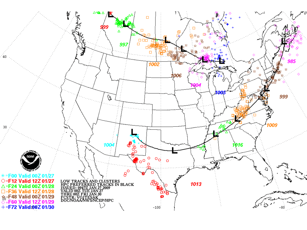
HPC keeps the main storm track across N Central and N TX, but a lot of Southern Stream Moisture "could" fall S of the track.
Edit to add Update from HGX...
HGX Update...
AREA FORECAST DISCUSSION
NATIONAL WEATHER SERVICE HOUSTON/GALVESTON TX
1003 AM CST TUE JAN 27 2009
.DISCUSSION...
FRONT HAS PUSHED INTO NRN ZONES AND HIGH TEMPS HAVE BEEN REACHED
FOR THE DAY THERE. EXPECT THE BOUNDARY TO SAG TO ROUGHLY THE HWY
59 CORRIDOR BY 3PM AND OFF THE COAST DURING THE EARLY EVENING
HOURS.
FOR THE UPDATE...TWEAKED CLOUD COVER TO MATCH ONGOING TRENDS (PC
SOUTH), LOWERED POPS A BIT AND ALSO RAISED HIGHS ACROSS SRN ZONES
A SEVERAL CATEGORIES.
WILL MAKE A DECISION AS TO WHAT WE`RE GOING TO DO WITH THE WATCH
LATER THIS AFTERNOON AFTER LOOKING AT THE FULL 12Z MODEL SUITE.
AFTER LOOKING AT THE NAM12...FIRST GUESS WOULD BE TO GO W/
FREEZING RAIN ADVSY AND LET NEXT SHIFT UPGRADE TO ICE STORM
WARNING IF NEED BE. MORE ON THAT LATER AFTER WE LOOK AT ADDITIONAL
INFO. 47
0 likes

Who is online
Users browsing this forum: No registered users and 63 guests