Situation remains rather fliud. Austin/San Antonio to add Winter Storm Watch shortly...
Will add that Austin/San Antonio look to add Winter Storm Watch shortly...
AREA FORECAST DISCUSSION
NATIONAL WEATHER SERVICE AUSTIN/SAN ANTONIO TX
1216 PM CST MON JAN 26 2009
.UPDATE...
COLD AIR ACCELERATION WILL LIKELY PROMPT A WINTER WEATHER PRODUCT
IN THE AFTERNOON PACKAGE; A WINTER STORM WATCH APPEARS PROBABLE
FOR NORTHERN COUNTIES FOR TUES NIGHT/WED MORN, BUT ALSO NEED TO
CONSIDER POSSIBLE EARLY WINTER WEATHER THREATS FOR DURING THE DAY
TUESDAY FOR THE NORTHERNMOST COUNTIES. TEMPS AND PRECIP CHARACTER
ADJUSTED THROUGH WEDNESDAY MORNING WITH MORE SUBTLE ADJUSTMENTS
POSSIBLE IN THE AFTERNOON PACKAGE.
2008-09 Texas Winter Weather Thread
Moderator: S2k Moderators
Forum rules
 The posts in this forum are NOT official forecast and should not be used as such. They are just the opinion of the poster and may or may not be backed by sound meteorological data. They are NOT endorsed by any professional institution or STORM2K.

The posts in this forum are NOT official forecast and should not be used as such. They are just the opinion of the poster and may or may not be backed by sound meteorological data. They are NOT endorsed by any professional institution or STORM2K.
-
srainhoutx

- S2K Supporter

- Posts: 6919
- Age: 68
- Joined: Sun Jan 14, 2007 11:34 am
- Location: Haywood County, NC
- Contact:
-
Portastorm

- Storm2k Moderator

- Posts: 9955
- Age: 63
- Joined: Fri Jul 11, 2003 9:16 am
- Location: Round Rock, TX
- Contact:
Re: 2008-09 Texas Winter Weather Thread
Hmmm ... that is interesting. I'm hoping tomorrow isn't one of those days where we all go to school and work and by late morning the weather deteriorates and we all get sent home ... to battle crummy roads and traffic jams. That always seems to happen here.
Meanwhile, Portastorm fidgets nervously and starts doing a mental inventory on where he last left his kicking shoes.
Meanwhile, Portastorm fidgets nervously and starts doing a mental inventory on where he last left his kicking shoes.
0 likes
-
somethingfunny

- ChatStaff

- Posts: 3926
- Age: 37
- Joined: Thu May 31, 2007 10:30 pm
- Location: McKinney, Texas
Re:
gboudx wrote:Crap. Hopefully I can get home before it starts tomorrow. We lost power for 3 hours the last time we had light icing at the house, but that may not have been related to the weather. Don't know. Hopefully that air winds up being deeper and we get more sleet than ice.
I wouldn't even try to get into work tomorrow. You're looking at freezing rain TONIGHT, then temps maybe cracking 33 or 34 and then falling back below freezing before sunset Tuesday.
0 likes
-
gboudx

- S2K Supporter
- Posts: 4090
- Joined: Thu Sep 04, 2003 1:39 pm
- Location: Rockwall, Tx but from Harvey, La
Re: Re:
somethingfunny wrote:gboudx wrote:Crap. Hopefully I can get home before it starts tomorrow. We lost power for 3 hours the last time we had light icing at the house, but that may not have been related to the weather. Don't know. Hopefully that air winds up being deeper and we get more sleet than ice.
I wouldn't even try to get into work tomorrow. You're looking at freezing rain TONIGHT, then temps maybe cracking 33 or 34 and then falling back below freezing before sunset Tuesday.
Luckily I have a boss that is an even bigger weather geek than me. He sent an email to his team telling us to all just plan to work from home tomorrow.
0 likes
-
srainhoutx
- S2K Supporter
- Posts: 6919
- Age: 68
- Joined: Sun Jan 14, 2007 11:34 am
- Location: Haywood County, NC
- Contact:
Re: Re:
gboudx wrote:somethingfunny wrote:gboudx wrote:Crap. Hopefully I can get home before it starts tomorrow. We lost power for 3 hours the last time we had light icing at the house, but that may not have been related to the weather. Don't know. Hopefully that air winds up being deeper and we get more sleet than ice.
I wouldn't even try to get into work tomorrow. You're looking at freezing rain TONIGHT, then temps maybe cracking 33 or 34 and then falling back below freezing before sunset Tuesday.
Luckily I have a boss that is an even bigger weather geek than me. He sent an email to his team telling us to all just plan to work from home tomorrow.
That's a good boss. We did the same with past events in SE TX when we had many employees. Folks, this has the pontential for a very widespread event. Keep informed.
0 likes
-
gboudx
- S2K Supporter
- Posts: 4090
- Joined: Thu Sep 04, 2003 1:39 pm
- Location: Rockwall, Tx but from Harvey, La
Latest update from Jeff Lindner:
One point about this in the DFW area is that the last time we had freezing rain, it had followed some very warm temps. So ground temps were warm enough that the streets didn't have ice, nor did most of the bridges and overpasses. Ice was visible on signs, traffic lights, etc. However, it's been quite cool the past few days so ground surfaces are cooler than last time.
NWS has issued an Ice Storm Warning for much of N TX through noon Wednesday.
Cold arctic air mass will invade N TX this evening with onset of freezing temps. by mid evening. Shallow air mass will be overrun by moisture resulting in periods of freezing drizzle and freezing rain through Wednesday. Surface temps. should remain at or below freezing through the entire period resulting in some significant ice accumulation.
Icing and glazing of roads will begin late tonight and continue through Tuesday into early Wednesday before rainfall ends. Initial ideas suggest 1/4th to ½ inch of icing and accumulation resulting in very hazardous driving and possible power outages.
Should rainfall amounts be slightly greater more significant ice accumulation may result in widespread power disruption and vegetation damage.
One point about this in the DFW area is that the last time we had freezing rain, it had followed some very warm temps. So ground temps were warm enough that the streets didn't have ice, nor did most of the bridges and overpasses. Ice was visible on signs, traffic lights, etc. However, it's been quite cool the past few days so ground surfaces are cooler than last time.
0 likes
-
srainhoutx
- S2K Supporter
- Posts: 6919
- Age: 68
- Joined: Sun Jan 14, 2007 11:34 am
- Location: Haywood County, NC
- Contact:
Re: 2008-09 Texas Winter Weather Thread
HGX strongly "hinting" a Winter Storm Watch "may" be needed locally particularly N and W of Metro Area as this fluid situation continues to unfold...
AREA FORECAST DISCUSSION
NATIONAL WEATHER SERVICE HOUSTON/GALVESTON TX
257 PM CST MON JAN 26 2009
.DISCUSSION...
FAIRLY DRAMATIC INCREASE IN BOTH TEMPS AND SRLY WINDS AS THE WARM
FRONT PUSHED THRU THE WRN HALF OF THE REGION TODAY. WARM NIGHT ON
TAP WITH SRLY FLOW CONTINUING. WILL PROBABLY SEE SOME AREAS OF FOG
DEVELOPING ESP NEAR THE COAST WHERE SEA FOG IS A GOOD BET.
COLD FRONT SHOULD BE ENTERING NRN PORTIONS OF SE TX SHORTLY AFTER
SUNRISE TUE WITH A SUBSTANTIAL TEMP DROP IN ITS WAKE. THE BOUNDARY
SHOULD PUSH OFF THE COAST DURING THE EVENING HOURS.
THINGS GET INTERESTING TUE NIGHT. H5 TROF LINGERING TO THE WEST
WILL KEEP A PACIFIC MOISTURE TAP ROLLING IN. AND WITH THE FRONT
BEING SO SHALLOW...GULF MOISTURE WILL ALSO BE OVERRUNNING THE
BOUNDARY. ANTICIPATE A SWATH OF PRECIPITATION TO DEVELOP FROM THE
BIG BEND AREA UP INTO THE TENN VALLEY TUE EVENING AND SAG SWD THRU
THE NIGHT AS TEMPS AT THE SFC FALL WELL INTO THE 30S. THE COLDEST
12Z MODEL I COULD FIND (NAM12 - WHICH ALSO TYPICALLY HANDLES SHALLOW
COLD AIRMASSES THE BEST) KEPT SFC TEMPS NORTH OF A BRENHAM-GROVETON
LINE IN THE 33-35 DEGREE RANGE WITH DEWPOINTS 31-33...MOST LIKELY
SIGNALING MOST (IF NOT ALL) LIQUID PRECIP ASSUMING NOT MUCH EVAP
COOLING TOOK PLACE. HOWEVER...THE INCOMING 18Z NAM12 IS COMING IN
COLDER. IT`S SHOWING THAT SAME AREA WITH SFC TEMPS AROUND FREEZING
WITH DEWPOINTS IN THE UPPER 20S. THIS ALONG WITH FCST SOUNDINGS
WOULD SUGGEST FREEZING RAIN. SINCE WE STILL HAVE SOME TIME TO
INVESTIGATE ANOTHER MODEL RUN AND STILL GIVE ABOUT 24 HOURS
NOTICE...PREFER TO HOLD OFF ON A WINTER STORM WATCH AND LET THE
MIDNIGHT CREW INVESTIGATE THE 00Z RUNS WHICH WILL HAVE MORE DATA
INGESTED THAN THE 18Z VARIETY. IF NOTHING CHANGES BETWEEN THE 18Z
& OOZ RUNS WOULD NOT DOUBT IF A WATCH IS ISSUED FOR TUE NIGHT &
EARLY WED MORNING FOR THE NRN 1/4 TO 1/3 OF THE REGION. WILL
ISSUE AN SPS IN A BIT.
PRECIP SHOULD COME TO AN END WED MORNING AS THE TROF PUSHES EAST
OF THE AREA. ANOTHER REINFORCING COLD FRONT STILL ON TAP LATE
THURS/FRI. MODIFYING TREND BEGINS DURING THE WEEKEND AS ONSHORE
FLOW RESUMES. 47
0 likes
-
jasons2k

- Storm2k Executive

- Posts: 8290
- Age: 52
- Joined: Wed Jul 06, 2005 12:32 pm
- Location: The Woodlands, TX
I enjoyed the warm weather while it lasted.
BTW - just to give you and idea of how these warm winters are messing with the plants here in the Houston area - there are bradford pears outside of my office that are just now showing their "peak" fall colors of red & orange. Meanwhile, the flower beds under them have azaleas that are bursting with red blooms. It's like fall & spring all at once.
And meanwhile down the road is a yard with schlefferas, papayas, and a royal palm that are more suited for South Florida but they haven't been freeze-burned here in years. Oh, and the bananas plants in the Galleria area are all green too. Crazy stuff.
(edited to clarify the 1st sentence).
0 likes
-
srainhoutx
- S2K Supporter
- Posts: 6919
- Age: 68
- Joined: Sun Jan 14, 2007 11:34 am
- Location: Haywood County, NC
- Contact:
Re: 2008-09 Texas Winter Weather Thread
FDW suggesting 1/2 inch of accumulation and possible 1 inch in the southern 2/3rds of CWA...
AREA FORECAST DISCUSSION
NATIONAL WEATHER SERVICE FORT WORTH TX
320 PM CST MON JAN 26 2009
.DISCUSSION...
THERE ARE STILL SOME UNCERTAINTIES IN THE MODELS THIS AFTERNOON
CONCERNING THE POTENTIAL ICE STORM OVER THE NEXT 24 TO 36 HOURS.
THE NAM/RUC HAVE THE SECONDARY SURGE OF COLD AIR MOVING THROUGH
THE CWA OVERNIGHT TONIGHT WITH TEMPERATURES DROPPING BELOW
FREEZING FOR THE NORTHERN HALF OF NORTH TEXAS BY DAYBREAK. THE
GFS/ECMWF/UKMET HAVE THE FRONT MUCH LATER NOT MAKING IT INTO THE
CWA UNTIL AFTER DAY BREAK. TEMPERATURES TOMORROW MORNING WILL BE
DEPENDANT ON FROPA TIMING. CURRENT THINKING IS THE NAM/RUC HAVE
THE BEST HANDLE ON THE TIMING OF THE FRONT AS THEY ARE THE MOST
CONSISTENT MODELS WHEN IT COMES TO FORECASTING SHALLOW COLD ARCTIC
AIR MASSES. HAVE BLENDED CLOSER TO THE NAM GUIDANCE AND HAVE
TEMPERATURES DIPPING BELOW FREEZING IN THE METROPLEX AROUND 6AM.
THE GFS STILL FORECASTS FREEZING TEMPERATURES BUT 6 HOURS LATER
BEHIND ITS FROPA.
REGARDING PRECIP...ISENTROPIC LIFT IS ONGOING AND WILL CONTINUE
THROUGH THE NIGHT AND INTO TOMORROW AS A STRONG LLJ CONTINUES
AHEAD OF TROUGH OVER THE WESTERN CONUS. THE ATMOSPHERE WILL
CONTINUE TO MOISTEN TONIGHT AND COVERAGE OF PRECIPITATION WILL
INCREASE THROUGHOUT THE NIGHT. THE TROUGH WILL MOVE EASTWARD
PROVIDING LARGE SCALE LIFT ACROSS THE AREA TOMORROW. AFTER THE
SURFACE FRONT PASSES TOMORROW...FRONTOGENESIS IN THE 600 - 925 MB
LAYER WILL LAG NORTH OF THE SURFACE BOUNDARY. THE BEST INSTABILITY
ALOFT WILL EXIST IN THE 850 TO 700 MB LAYER AND THUS PRECIPITATION
TOMORROW NIGHT SHOULD FOLLOW THIS ZONE CLOSELY. AT 6 PM
TOMORROW...THE BEST POTENTIAL FOR HEAVIER PRECIPITATION WILL BE
ACROSS THE SOUTHERN 2/3RDS OF THE CWA AND WILL CONTINUE TO SHIFT
SOUTHWARD AS THE BOUNDARY CONTINUES TO DRAG TO THE SOUTH OVERNIGHT
TUESDAY. TEMPERATURES AT SUNRISE WEDNESDAY WILL BE BELOW FREEZING
AREA WIDE AND ALL PRECIPITATION THAT DOES FALL WILL FREEZE ON
CONTACT. EVENT TOTAL PRECIPITATION AMOUNTS WILL GENERALLY AVERAGE
A 1/2 AN INCH WITH ISOLATED TOTALS REACHING AN INCH. THERE IS
DEFINITELY THE POTENTIAL FOR A SIGNIFICANT ICING EVENT ACROSS
PORTIONS OF NORTH TEXAS AND RESIDENTS SHOULD TAKE THE APPROPRIATE
PRECAUTIONS.
MOST PRECIP WILL BE IN THE FORM OF RAIN OR FREEZING RAIN.
HOWEVER...THERE IS A BRIEF WINDOW OVERNIGHT TUESDAY WHEN
THICKNESS VALUES WOULD BE SUPPORTIVE OF SLEET MIXED IN WITH THE
FREEZING RAIN GENERALLY FOR THE NORTHERN HALF OF THE CWA...BUT
PRECIP CHANCES WILL BE DWINDLING IN THESE AREAS AT THAT TIME.
0 likes
-
Portastorm
- Storm2k Moderator
- Posts: 9955
- Age: 63
- Joined: Fri Jul 11, 2003 9:16 am
- Location: Round Rock, TX
- Contact:
Re: 2008-09 Texas Winter Weather Thread
Wow ... I think it has been several years since I have seen a Winter Storm Watch issued for the Austin area.
INCLUDING THE CITIES OF...AUSTIN
335 PM CST MON JAN 26 2009
...WINTER STORM WATCH IN EFFECT FROM TUESDAY EVENING THROUGH
WEDNESDAY MORNING...
.TONIGHT...CLOUDY WITH A 20 PERCENT CHANCE OF RAIN. PATCHY FOG.
COLDER. LOWS 39 TO 45. EAST WINDS 5 TO 10 MPH SHIFTING TO THE
NORTH 10 TO 15 MPH AFTER MIDNIGHT.
.TUESDAY...PATCHY FOG IN THE MORNING. CLOUDY WITH A 40 PERCENT
CHANCE OF RAIN. COOLER. NEAR STEADY TEMPERATURE IN THE LOWER 40S.
NORTH WINDS 15 TO 20 MPH.
.TUESDAY NIGHT...RAIN...LIGHT SLEET LIKELY AND OCCASIONAL
FREEZING RAIN BEFORE MIDNIGHT...THEN RAIN...LIGHT SLEET AND
FREEZING RAIN LIKELY AFTER MIDNIGHT. NO SLEET ACCUMULATION. ICE
ACCUMULATION OF LESS THAN ONE QUARTER OF AN INCH. COLDER. LOWS IN
THE LOWER 30S. NORTH WINDS 10 TO 15 MPH. CHANCE OF PRECIPITATION
80 PERCENT.
.WEDNESDAY...CLOUDY. SLIGHT CHANCE OF RAIN...FREEZING RAIN AND
LIGHT SLEET IN THE MORNING...THEN A SLIGHT CHANCE OF RAIN IN THE
AFTERNOON. HIGHS IN THE LOWER 50S. NORTH WINDS 5 TO 10 MPH.
CHANCE OF PRECIPITATION 20 PERCENT.
0 likes
-
Tireman4

- S2K Supporter
- Posts: 5904
- Age: 60
- Joined: Fri Jun 30, 2006 1:08 pm
- Location: Humble, Texas
- Contact:
Re: 2008-09 Texas Winter Weather Thread
Is it me, or are things getting progressively worse (forecast wise) and generally this mess is heading in a southerly direction?
0 likes
-
srainhoutx
- S2K Supporter
- Posts: 6919
- Age: 68
- Joined: Sun Jan 14, 2007 11:34 am
- Location: Haywood County, NC
- Contact:
Re: 2008-09 Texas Winter Weather Thread
Actually HGX discussed a couple of days ago that this "may" happen in their AFD. Due to modeling issues last week and the constant changes that were occuring, it was probably prudent to wait a bit before jumping on the trends so far in advance IMHO.
0 likes

Re:
jasons wrote::uarrow: Looks like when it's all said & done it will be north of Columbus-Conroe-Livingston (at least). I don't see anything yet that would push the threat any further south of that.
I enjoyed the warm weather while it lasted.
BTW - just to give you and idea of how these warm winters are messing with the plants here in the Houston area - there are bradford pears outside of my office that are just now showing their "peak" fall colors of red & orange. Meanwhile, the flower beds under them have azaleas that are bursting with red blooms. It's like fall & spring all at once.(edited to clarify the 1st sentence).
Many varieties of azaleas normally get blooms in the Christmas to early January time frame...so that by itself doesn't say much....
I notice in SELA the maples are putting out their red seeds...very obvious driving across the spillways....between NOLA and BR and Lafayette....some of my oaks (not live) have not really shed their leaves...they never got to the bare stage and probably won't drop until the buds start to swell...
Luckily my small fruit trees are holding on!!!!
0 likes
-
PTrackerLA

- Category 5

- Posts: 5281
- Age: 42
- Joined: Thu Oct 10, 2002 8:40 pm
- Location: Lafayette, LA
Re: 2008-09 Texas Winter Weather Thread
I've noticed a few trees around the area that are showing "fall" colors, especially in Baton Rouge. There's a simple explanation for this for here and the Houston area; hurricanes Gustav and Ike stripped many trees in September only for them to re-foliate out of season in late september, early october which has caused a big delay in some trees losing their leaves. Just an interesting occurrence caused by hurricane winds that I first noticed back in 2002 after hurricane Lili.
Stay safe all those who will be affected by this winter storm!
Stay safe all those who will be affected by this winter storm!
0 likes
-
Ed Mahmoud
Re: 2008-09 Texas Winter Weather Thread
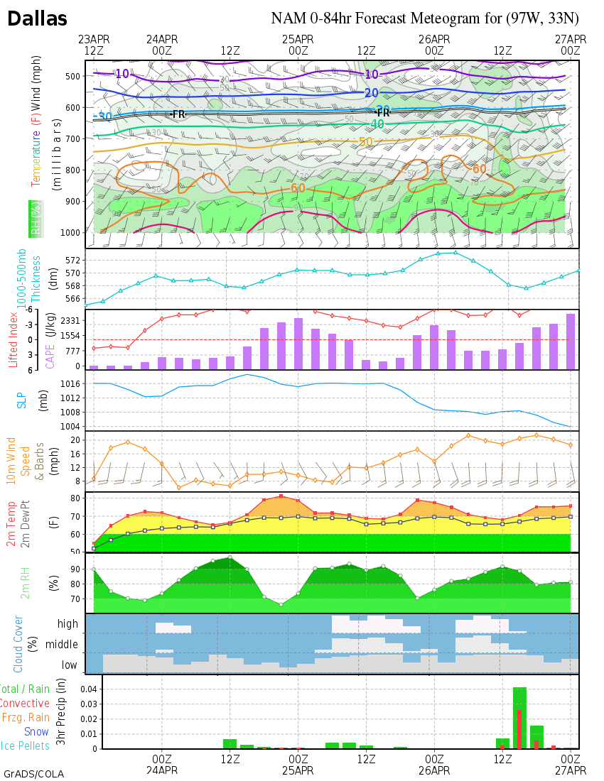
New NAM- smidge over a quarter inch of precip falling into sub-freezing air at DFW
0 likes
Re: 2008-09 Texas Winter Weather Thread
We're starting to see weeds that normally don't show till March.
It's currently 71F here and misty at 9pm. If the cold front was coming tonight I'd say we were in for an ice storm. Now I'm thinking we're going to have something similar to what we had earlier in the season ... altho they're saying into the morning....
If so I can get a picture of our dog zooming in the sleet. The ones I have look like 2 glowing eyes in a black closet...
I'm not going to get too excited though yet.
0 likes
-
somethingfunny
- ChatStaff
- Posts: 3926
- Age: 37
- Joined: Thu May 31, 2007 10:30 pm
- Location: McKinney, Texas
-
Ed Mahmoud
Re: 2008-09 Texas Winter Weather Thread

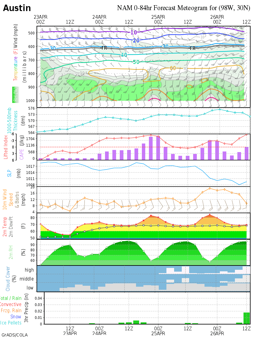
Austin- near miss, but by less than 1ºF over several hours- too close for comfort!- my AccuWx PPV says two tenths fall below freezing just up I-35 past the San Gabriel river in Georgetown!
0 likes
Who is online
Users browsing this forum: No registered users and 147 guests