#2 Postby DanieleItalyRm » Tue Jan 13, 2009 7:03 am
sorry,I don't know..
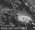
but if this a subtropical storm?
it's have a warm core,not cold core
ESTOFEX 13/01/09 : Warning-Sicily, Malta, southern Italy, western Greece-
Active convective weather is found around the low pressure system between Tunesia and the Balkan. A plume of warm air surges into southern Italy and beyond, with 0-1 km theta-w values of 15°..
This is when the highest CAPE is present of about 1000 J/kg and capping is forecast to be weakest. Deep layer shear of 20-25 m/s is forecast over 0-6 km and 1-8 km, sufficient to sustain long-lived MCS and development of supercells. 0-3 km SREH is enhanced to >200 m²/s² and a factor of two higher at the warm front itself, where however predicted CAPE is lower or absent.
The main threat of the storms is large hail. Secondary is the possibility of isolated tornado occurrence, given 0-1 km shear is at least 10-15 m/s, relatively low LCL heights, and weak downdraft CAPE. The highest potential is over Sicily and southern Italy. Waterspouts are possible also in weaker shear.
Last edited by
DanieleItalyRm on Tue Jan 13, 2009 11:52 am, edited 1 time in total.
0 likes