
All I know is that I want one good snowstorm - the type that keeps us in for a couple of days.
I'm disappointed that the storms this coming week will once again bring the warm air over the Delaware Valley. Ten days ago, the GFS was showing storms for this time period, but with snow. Oh well, should've known better...
Southern Plains winter wx thread (2008-2009)
Moderator: S2k Moderators
Forum rules
 The posts in this forum are NOT official forecast and should not be used as such. They are just the opinion of the poster and may or may not be backed by sound meteorological data. They are NOT endorsed by any professional institution or STORM2K.

The posts in this forum are NOT official forecast and should not be used as such. They are just the opinion of the poster and may or may not be backed by sound meteorological data. They are NOT endorsed by any professional institution or STORM2K.


Re: Another round of frigid air to arrive in early January?
Brent wrote:Ed Mahmoud wrote:jinftl wrote:From NWS Miami...
Wow, looks like Tallahassee has even more brutal winter weather than Houston. They should cede it to Georgia in exchange for SSI.
Tallahassee gets frigid at times yeah, their all-time record low is only 3 degrees off ours.

-2F in the 1899.
Jacksonville has hit 7F back in 1985. That sucked big ones. No frost, no snow, just blistering cold.
According to this:
http://www.ncdc.noaa.gov/oa/climate/onl ... melow.html
North Florida and the Panhandle are a climate away from South Florida for sure.
0 likes
-
Portastorm

- Storm2k Moderator

- Posts: 9955
- Age: 63
- Joined: Fri Jul 11, 2003 9:16 am
- Location: Round Rock, TX
- Contact:
Re: Another round of frigid air to arrive in early/mid January?
Several Texas NWSFOs are on board with the Euro's insistence for an Arctic outbreak next week.
Austin/San Antonio writes:
THE 00Z ECMWF CONTINUES TO SHOW A MASSIVE AND
BROAD SYNOPTIC SCALE TROUGH DEVELOPING OVER THE U.S. BEYOND 180H
..WHICH WILL ALLOW FOR A BITTERLY COLD ARCTIC AIRMASS TO SPILL
SOUTHWARD INTO THE PLAINS STATES NEXT WEEK. THIS AIRMASS MAY
AFFECT OUR AREA AS EARLY AS WEDNESDAY OF NEXT WEEK AND WOULD BE
THE COLDEST SO FAR THIS SEASON.
Houston writes:
ECMWF INDICATE A 1050 HIGH
PUSHING SOUTHEAST (IN THE NORTHWEST UPPER LEVEL STEERING CURRENT)
REACHING OUR AREA AFTER THE MIDDLE OF NEXT WEEK.
And I should add that the GFS ensembles -- for the 2nd day in a row -- also support this line of thinking, especially after about 192 hours:
http://www.emc.ncep.noaa.gov/gmb/ens/targ/z500ensmnP3.2009010600.html
0 likes
-
cctxhurricanewatcher

- Category 5

- Posts: 1206
- Joined: Sun Sep 12, 2004 8:53 pm
- Location: Corpus Christi, Texas
Re: Another round of frigid air to arrive in early/mid January?
Portastorm wrote:Several Texas NWSFOs are on board with the Euro's insistence for an Arctic outbreak next week.
Austin/San Antonio writes:
THE 00Z ECMWF CONTINUES TO SHOW A MASSIVE AND
BROAD SYNOPTIC SCALE TROUGH DEVELOPING OVER THE U.S. BEYOND 180H
..WHICH WILL ALLOW FOR A BITTERLY COLD ARCTIC AIRMASS TO SPILL
SOUTHWARD INTO THE PLAINS STATES NEXT WEEK. THIS AIRMASS MAY
AFFECT OUR AREA AS EARLY AS WEDNESDAY OF NEXT WEEK AND WOULD BE
THE COLDEST SO FAR THIS SEASON.
Houston writes:
ECMWF INDICATE A 1050 HIGH
PUSHING SOUTHEAST (IN THE NORTHWEST UPPER LEVEL STEERING CURRENT)
REACHING OUR AREA AFTER THE MIDDLE OF NEXT WEEK.
And I should add that the GFS ensembles -- for the 2nd day in a row -- also support this line of thinking, especially after about 192 hours:
http://www.emc.ncep.noaa.gov/gmb/ens/targ/z500ensmnP3.2009010600.html
I'm shocked they are jumping on board this far out. Which makes me think it might not happen.
0 likes
-
srainhoutx

- S2K Supporter

- Posts: 6919
- Age: 68
- Joined: Sun Jan 14, 2007 11:34 am
- Location: Haywood County, NC
- Contact:
Re: Another round of frigid air to arrive in early/mid January?
Portastorm wrote:Several Texas NWSFOs are on board with the Euro's insistence for an Arctic outbreak next week.
Austin/San Antonio writes:
THE 00Z ECMWF CONTINUES TO SHOW A MASSIVE AND
BROAD SYNOPTIC SCALE TROUGH DEVELOPING OVER THE U.S. BEYOND 180H
..WHICH WILL ALLOW FOR A BITTERLY COLD ARCTIC AIRMASS TO SPILL
SOUTHWARD INTO THE PLAINS STATES NEXT WEEK. THIS AIRMASS MAY
AFFECT OUR AREA AS EARLY AS WEDNESDAY OF NEXT WEEK AND WOULD BE
THE COLDEST SO FAR THIS SEASON.
Houston writes:
ECMWF INDICATE A 1050 HIGH
PUSHING SOUTHEAST (IN THE NORTHWEST UPPER LEVEL STEERING CURRENT)
REACHING OUR AREA AFTER THE MIDDLE OF NEXT WEEK.
And I should add that the GFS ensembles -- for the 2nd day in a row -- also support this line of thinking, especially after about 192 hours:
http://www.emc.ncep.noaa.gov/gmb/ens/targ/z500ensmnP3.2009010600.html
I've been watching the trends over that last several days Portastorm. Although nothing pipe busting, there is a lot of Cold Air poised to slide down from AK and NW Canada next week. Looks like a Blue Norther to me.

0 likes
-
Portastorm
- Storm2k Moderator
- Posts: 9955
- Age: 63
- Joined: Fri Jul 11, 2003 9:16 am
- Location: Round Rock, TX
- Contact:
Re: Another round of frigid air to arrive mid January?
Hey gang, normally I would agree with you in that when one of our (Texas) local weather forecast offices picks up on an Arctic outbreak this far out and mentions it, that is the proverbial "kiss of death." But in this case, the ECMWF has shown this scenario for two days straight.
When it comes to models (computer models, that is!), I'm a Europhile. Especially in winter. Given the Euro's consistency and track record ... seeing that some very respected pro mets on other boards have been talking for days about a deep trough developing over portions of the central and eastern U.S. ... seeing those bitter cold Alaska temps ... and seeing that the GFS ensembles basically show the same, I'm thinking there is something to this.
Then again, I've been known to get suckered from time to time.
0 likes
-
cctxhurricanewatcher
- Category 5
- Posts: 1206
- Joined: Sun Sep 12, 2004 8:53 pm
- Location: Corpus Christi, Texas
Re: Another round of frigid air to arrive mid January?
Portastorm wrote:Hey gang, normally I would agree with you in that when one of our (Texas) local weather forecast offices picks up on an Arctic outbreak this far out and mentions it, that is the proverbial "kiss of death." But in this case, the ECMWF has shown this scenario for two days straight.
When it comes to models (computer models, that is!), I'm a Europhile. Especially in winter. Given the Euro's consistency and track record ... seeing that some very respected pro mets on other boards have been talking for days about a deep trough developing over portions of the central and eastern U.S. ... seeing those bitter cold Alaska temps ... and seeing that the GFS ensembles basically show the same, I'm thinking there is something to this.
Then again, I've been known to get suckered from time to time.
I see what your saying. What is JB saying this AM?
0 likes
-
Extremeweatherguy

- Category 5
- Posts: 11095
- Joined: Mon Oct 10, 2005 8:13 pm
- Location: Florida
Re: Another round of frigid air to arrive mid January?
He still thinks it will be getting very cold by mid January, and is calling for a low of 0F in NYC and at least one sub-0F day in Chicago before it is all said and done.cctxhurricanewatcher wrote:Portastorm wrote:Hey gang, normally I would agree with you in that when one of our (Texas) local weather forecast offices picks up on an Arctic outbreak this far out and mentions it, that is the proverbial "kiss of death." But in this case, the ECMWF has shown this scenario for two days straight.
When it comes to models (computer models, that is!), I'm a Europhile. Especially in winter. Given the Euro's consistency and track record ... seeing that some very respected pro mets on other boards have been talking for days about a deep trough developing over portions of the central and eastern U.S. ... seeing those bitter cold Alaska temps ... and seeing that the GFS ensembles basically show the same, I'm thinking there is something to this.
Then again, I've been known to get suckered from time to time.
I see what your saying. What is JB saying this AM?
Last edited by Extremeweatherguy on Tue Jan 06, 2009 9:45 am, edited 1 time in total.
0 likes
-
cctxhurricanewatcher
- Category 5
- Posts: 1206
- Joined: Sun Sep 12, 2004 8:53 pm
- Location: Corpus Christi, Texas
Re: Another round of frigid air to arrive mid January?
Extremeweatherguy wrote:He still thinks it will be getting very cold by mid January, and is calling for a low of 0F in NYC and a sub-0F day in Chicago before it is all said and done.cctxhurricanewatcher wrote:Portastorm wrote:Hey gang, normally I would agree with you in that when one of our (Texas) local weather forecast offices picks up on an Arctic outbreak this far out and mentions it, that is the proverbial "kiss of death." But in this case, the ECMWF has shown this scenario for two days straight.
When it comes to models (computer models, that is!), I'm a Europhile. Especially in winter. Given the Euro's consistency and track record ... seeing that some very respected pro mets on other boards have been talking for days about a deep trough developing over portions of the central and eastern U.S. ... seeing those bitter cold Alaska temps ... and seeing that the GFS ensembles basically show the same, I'm thinking there is something to this.
Then again, I've been known to get suckered from time to time.
I see what your saying. What is JB saying this AM?
Anything about Texas?
0 likes
-
Extremeweatherguy
- Category 5
- Posts: 11095
- Joined: Mon Oct 10, 2005 8:13 pm
- Location: Florida
Re: Another round of frigid air to arrive mid January?
He mentioned the possibility of a citrus freeze into south Texas, but didn't go into much detail about it. Hopefully he will elaborate more on this potential threat in the days to come.cctxhurricanewatcher wrote:Extremeweatherguy wrote:He still thinks it will be getting very cold by mid January, and is calling for a low of 0F in NYC and a sub-0F day in Chicago before it is all said and done.cctxhurricanewatcher wrote:
I see what your saying. What is JB saying this AM?
Anything about Texas?
0 likes
-
CaptinCrunch

- S2K Supporter
- Posts: 8786
- Age: 58
- Joined: Mon Nov 03, 2003 4:33 pm
- Location: Kennedale, TX (Tarrant Co.)
Re: Another round of frigid air to arrive mid January?
Well if it does happen better for this type of setup.
After all said and done we got .51 in the rain gauge, now translate that over into snow and your looking at 3-5 inches.
AN APPROACHING SYSTEM TO THE WEST WILL DRAW WARM MOIST AIR OVER THE
COLD CANADIAN AIR SETTLING OVER NORTH TEXAS. PRECIPITATION IS ON
THE INCREASE TO THE WEST AND SOUTHWEST AND WILL SPREAD OVER NORTH
TEXAS TAF SITES BEFORE MID MORNING AND CONTINUING THROUGH THE NIGHT.
FIRST ROUND OF LIGHT FREEZING RAIN...SLEET...AND RAIN IS MOVING
OFF INTO EAST TEXAS WITH A BAND OF PRECIP LOCATED FROM PARIS TO
GOLDTHWAITE. WATER VAPOR SHOWS NEXT BATCH OF PRECIPITATION OVER
WEST TEXAS NOW AS POSITIVELY TILTED TROUGH AXIS SWINGS INTO
NORTHERN MEXICO. MUCH OF NORTH TEXAS SHOULD SEE A BREAK IN THE
PRECIP FOR A FEW HOURS BEFORE LARGE SCALE ASCENT ASSOCIATED WITH
THE UPPER LEVEL TROUGH ARRIVES
After all said and done we got .51 in the rain gauge, now translate that over into snow and your looking at 3-5 inches.
0 likes
-
gatorcane

- S2K Supporter
- Posts: 23708
- Age: 48
- Joined: Sun Mar 13, 2005 3:54 pm
- Location: Boca Raton, FL
Re: Another round of frigid air to arrive mid January?
Here is a link to the 00Z ECMWF at 168 hours showing the massive trough. If this verifies, it would bring the coldest weather of the season to much of the eastern part of the CONUS:
http://www.ecmwf.int/products/forecasts ... ca_168.gif
http://www.ecmwf.int/products/forecasts ... ca_168.gif
0 likes
-
SaskatchewanScreamer
Re: Another round of frigid air to arrive mid January?
Record breaking cold was recently (last couple of days) recorded in Saskatchewan.......then an Alberta Clipper (or Saskatchewan Screamer) went through. We've now warmed up considerably. Who's getting our loverly cold now?
0 likes
-
Extremeweatherguy
- Category 5
- Posts: 11095
- Joined: Mon Oct 10, 2005 8:13 pm
- Location: Florida
-
srainhoutx
- S2K Supporter
- Posts: 6919
- Age: 68
- Joined: Sun Jan 14, 2007 11:34 am
- Location: Haywood County, NC
- Contact:
Re: Another round of frigid air to arrive mid January?
EC and GFS looking in better agreement in the 12Z runs...
ECMWF @ 192 Hours 500mb

GFS @ 192 Hours 500mb
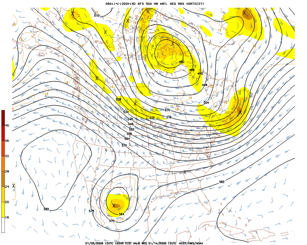
Some folks are going to get mighty cold.
ECMWF @ 192 Hours 500mb
GFS @ 192 Hours 500mb
Some folks are going to get mighty cold.
0 likes
Re: Another round of frigid air to arrive mid January?
Do the 2 model runs below show the heart of the cold air staying over the northeast, midwest, and northern plains? Looks fairly zonal as you move into the Deep South & Southern Plains...which is in-line with CPC Outlook as well.

srainhoutx wrote:EC and GFS looking in better agreement in the 12Z runs...
ECMWF @ 192 Hours 500mb
GFS @ 192 Hours 500mb
Some folks are going to get mighty cold.
0 likes
-
Portastorm
- Storm2k Moderator
- Posts: 9955
- Age: 63
- Joined: Fri Jul 11, 2003 9:16 am
- Location: Round Rock, TX
- Contact:
Re: Another round of frigid air to arrive mid January?
I'm not sure how serious we can take the 12z GFS run spinning up that upper-level low just to the southwest of Texas. The Euro has it off the Pacific Coast. It is the first time I've seen that in the modeling and the Euro and Canadian do not have it, so the GFS is the outlier.
However, the 12z run of the Euro carves out the trough a little further east than the 0z run. We've been saying all along that where the deep trough eventually carves out is where the real cold air will be. The runs you reference jinftl would indeed put very cold air in the Mid Atlantic states, Great Lakes, and the Northeast while the Southern Plains and Southeast escape. Subsequent model runs will be watched with interest.
However, the 12z run of the Euro carves out the trough a little further east than the 0z run. We've been saying all along that where the deep trough eventually carves out is where the real cold air will be. The runs you reference jinftl would indeed put very cold air in the Mid Atlantic states, Great Lakes, and the Northeast while the Southern Plains and Southeast escape. Subsequent model runs will be watched with interest.
0 likes
-
Ed Mahmoud
Re: Another round of frigid air to arrive mid January?
480 dm thicknesses and -35ºC 850 mb isotherms centered near Lake Superior- now that is chilly!

Euro not quite as cold, but not a good day for the beach!

Euro not quite as cold, but not a good day for the beach!
0 likes
-
Portastorm
- Storm2k Moderator
- Posts: 9955
- Age: 63
- Joined: Fri Jul 11, 2003 9:16 am
- Location: Round Rock, TX
- Contact:
Re: Another round of frigid air to arrive mid January?
Both the 0z GFS and Euro show a trajectory of the very cold air impacting the Northern Plains, Great Lakes, and Northeast ... today's trend eases up on the threat of Arctic air for the Southern Plains and Southeast.
0 likes
Re: Another round of frigid air to arrive mid January?
Looking at the charts above, what a difference it would make for parts of the u.s. if the trajectory of the cold is south vs. southeast. A more southerly path would seem to open the floodgates to at least the eastern 2/3 of the u.s....while a more southeasterly trajectory aims at the Great Lakes and Northeast most directly. Not a question of whether arctic air is available...just where will it head and what will steer it that could make all of the difference in any one location.
Portastorm wrote:Both the 0z GFS and Euro show a trajectory of the very cold air impacting the Northern Plains, Great Lakes, and Northeast ... today's trend eases up on the threat of Arctic air for the Southern Plains and Southeast.
0 likes
Who is online
Users browsing this forum: No registered users and 92 guests