2008-09 Texas Winter Weather Thread

Winter Weather Discussion

Moderator: S2k Moderators

Forum rules

The posts in this forum are NOT official forecast and should not be used as such. They are just the opinion of the poster and may or may not be backed by sound meteorological data. They are NOT endorsed by any professional institution or STORM2K.

Help Support Storm2K
Message
Author
User avatar
vbhoutex
Storm2k Executive
Storm2k Executive
Posts: 29112
Age: 73
Joined: Wed Oct 09, 2002 11:31 pm
Location: Cypress, TX
Contact:

Re:

#501 Postby vbhoutex » Sun Jan 04, 2009 1:06 am

josephtwyman wrote:the latest shows a warm nose in metroplex and it will increase the moisture after midnite into monday morning, also we are about to go in the coldest part of the season and could be interesting in the next two weeks so please keep a look out!.


You always make all these predictions with nothing to back them up. Please provide us with links so we too can see what you are seeing.

What is a "warm nose" and what will it do to th emetroplex weather and where is it coming from?
0 likes   

Ed Mahmoud

Re: 2008-09 Texas Winter Weather Thread

#502 Postby Ed Mahmoud » Sun Jan 04, 2009 1:13 am

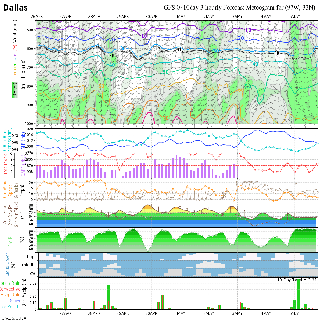
The wxmaps.org meteogram, which has a handy thermal profile, hasn't updated yet. But it should soon.

[img]Image[/img]
:uarrow: :uarrow: Hot link should update in about an hour.

This hotlinked image shows the 1000-500 mb critical thickness, the 700 mb thickness, and the 850 mb freezing line separated in such a way as to imply warmer air aloft, with the 850 mb line South of the 700 line South of the 500 line.

Image

I used the handy AccuWeather PPV GFS to see 2 meter temps below freezing in Northern and Western Tarrant and much of Denton County.

1 or 2ºF error in temperatures will have huge consequences for the Monday morning commute if the GFS is close to being correct. (No guarantee of that.)

Edit to further add- looking at AccuWx PPV GFS MOS for specific cities, temps actually drop slightly between 6 am and noon in the area, as relative humidities climb from below 50% to near 90%, implying some evaporative cooling helping with the possibility of freezing precip.
0 likes   

Ed Mahmoud

Re: 2008-09 Texas Winter Weather Thread

#503 Postby Ed Mahmoud » Sun Jan 04, 2009 1:34 am

Portastorm wrote:I posted something about this in the January thread ... but we're seeing some signs from the modeling that we might have an impressive front next weekend. Take a look at the Euro at 240 hr from the 12z run. Looks pretty cold:

http://www.ecmwf.int/products/forecasts/d/charts/medium/deterministic/msl_uv850_z500!Geopotential%20500%20hPa!240!North%20America!pop!od!oper!public_plots!2009010312!!/


Joe Bastardi mentioned that in his coumn update this evening. It seems the idea of 480 dm thicknesses with a 1055 mb high entering the US has helped him forget the heartache of the Rose Bowl.
0 likes   

User avatar
iorange55
Category 5
Category 5
Posts: 2388
Joined: Thu Nov 13, 2008 9:47 pm
Location: Big D

Re: 2008-09 Texas Winter Weather Thread

#504 Postby iorange55 » Sun Jan 04, 2009 4:49 am

Dallas Noaa Discussion.


FOR NOW...WE HAVE HELD TO PERSISTENCE ON FORECAST WITH POSSIBLE RAIN
AND/OR FREEZING RAIN EXTENDING JUST WEST THROUGH NORTH OF THE D/FW
METROPLEX...WITH MORE STEADY RAIN AND ISOLATED THUNDERSTORMS TOWARD
LAMPASAS...WACO/TEMPLE...AND OVER TOWARD ATHENS AND PALESTINE. CHECK
OF NCEP/HPC WINTER PROGS SHOW WELL BELOW 0.05 OF QPF IN SUB-FREEZING
AIRMASS...SO FOR NOW..WE WILL JUST INTRODUCE A SPECIAL WEATHER STATEMENT
REGARDING THE POTENTIAL FOR FREEZING RAIN OVER WRN/NRN NORTH TX AND
UNCERTAINTY. WE FOLLOWED SLIGHTLY WARMER GFSMOS LOWS TONIGHT...BUT
IF COLDER NAM/FWC VALUES COME TO FRUITION...IT COULD GET MESSY FROM
D/FW METRO WEST AND NORTH. FEEL ANOTHER RUN OF MODELS IS NEEDED IN
THIS SET UP TO GET ANY CONFIDENCE ON ANY WINTER WX HIGHLIGHTS FOR
MONDAY MORNING...BUT DEFINITELY BEARS WATCHING CLOSELY.

0 likes   

Ed Mahmoud

Re: 2008-09 Texas Winter Weather Thread

#505 Postby Ed Mahmoud » Sun Jan 04, 2009 9:48 am

HPC Winter Weather Discussion Snip...


SRN PLAINS/CENTRAL APPALACHIANS...
MOISTURE EJECTING FROM THE SWRN STATES MAY ENCOUNTER SUFFICIENT
RESIDUAL LOW LEVEL COLD AIR ON MONDAY FOR SOME ICING OVER PARTS OF
NORTH CNTRL TX...SRN/ERN OK...INTO NRN/WRN ARKANSAS. THIS
EVENTUALLY CONTINUES INTO THE MOUNTAINS OF NC AND SOUTHWEST VA.
FOLLOWING THE 00Z/ECMWF TEMPS AND PCPN PATTERN...QPF TOTALS IN TX
WILL BE MOSTLY LESS THAN .25 INCHES BUT A LOW THREAT FOR
SIGNIFICANT ICING IS SHOWN IN NORTHEAST TX AS GFS FCSTS GREATER
QPF AMOUNTS TO A QUARTER INCH WHILE SFC TEMPS ARE BELOW FREEZING.
OTHER MODELS FCST LIGHTER QPF TOTALS WHILE SFC TEMPS ARE BELOW
FREEZING.


Less than a quarter inch means no significant tree limb breakage and powerline failure, but that is well plenty enough to mess up driving and cause at least some delayed school openings.
0 likes   

User avatar
gboudx
S2K Supporter
S2K Supporter
Posts: 4080
Joined: Thu Sep 04, 2003 1:39 pm
Location: Rockwall, Tx but from Harvey, La

#506 Postby gboudx » Sun Jan 04, 2009 11:12 am

Most ISD's are closed on Monday/Tuesday. So this shouldn't affect much in the way of school closings.
0 likes   

User avatar
Portastorm
Storm2k Moderator
Storm2k Moderator
Posts: 9914
Age: 63
Joined: Fri Jul 11, 2003 9:16 am
Location: Round Rock, TX
Contact:

#507 Postby Portastorm » Sun Jan 04, 2009 11:20 am

Nothing like early January in Texas ... yesterday at 10 am, it was 70 degrees here in Austin. One day later, same time, 44 degrees and dropping with a north wind gusting to 20 mph. :lol:
0 likes   

Ed Mahmoud

Re: 2008-09 Texas Winter Weather Thread

#508 Postby Ed Mahmoud » Sun Jan 04, 2009 1:56 pm

Front seems to have passed, skies clearing some, lower humidity more noticeable than cold temps or gusty winds.
0 likes   

josephtwyman

#509 Postby josephtwyman » Sun Jan 04, 2009 3:10 pm

the latest model wrf-nam shows the moisture increasing by morning from southwest to downtown dallas so, it will be an adventure in the morning maybe an freezing rain warning!
0 likes   

Ed Mahmoud

Re: 2008-09 Texas Winter Weather Thread

#510 Postby Ed Mahmoud » Sun Jan 04, 2009 3:39 pm

18Z WRF (surface temps from AccuWx PPV) do show a co-location tomorrow morning/early afternoon of rain and sub-freezing temps near DFW.


For what that is worth.


Not in North Texas, but my wife's district goes back tomorrow.
0 likes   

User avatar
gboudx
S2K Supporter
S2K Supporter
Posts: 4080
Joined: Thu Sep 04, 2003 1:39 pm
Location: Rockwall, Tx but from Harvey, La

#511 Postby gboudx » Sun Jan 04, 2009 4:10 pm

>>Not in North Texas, but my wife's district goes back tomorrow.

As is usual here, not all ISD's have the same schedules. My wife just told me that the Frisco ISD starts back tomorrow, while our's here in Rockwall doesn't go back until Thursday. So, there could be school delay/cancellation issues if that model run verifies.
0 likes   

User avatar
iorange55
Category 5
Category 5
Posts: 2388
Joined: Thu Nov 13, 2008 9:47 pm
Location: Big D

Re: 2008-09 Texas Winter Weather Thread

#512 Postby iorange55 » Sun Jan 04, 2009 4:15 pm

Noaa has finally put freezing rain in the forecast for Dallas, an 80 percent chance before noon tomorrow.
0 likes   

User avatar
ntxweatherwatcher
Tropical Depression
Tropical Depression
Posts: 71
Joined: Thu Oct 23, 2008 3:55 pm
Location: Bedford, TX DFW

Re: 2008-09 Texas Winter Weather Thread

#513 Postby ntxweatherwatcher » Sun Jan 04, 2009 4:36 pm

[color=#400000][color=#800000]This should be interesting... My kids are supposed to go back tommorrow after winter break!! I wonder if we will be put under a freezing rain advisory or warning?[/[/color]color]
0 likes   

User avatar
iorange55
Category 5
Category 5
Posts: 2388
Joined: Thu Nov 13, 2008 9:47 pm
Location: Big D

Re: 2008-09 Texas Winter Weather Thread

#514 Postby iorange55 » Sun Jan 04, 2009 4:49 pm

Freezing rain advisory for dallas and points to the north.

...FREEZING RAIN ADVISORY LATE TONIGHT AND INTO MONDAY FOR
PORTIONS OF NORTH TEXAS...

.COLD AIR CENTERED OVER THE CENTRAL PLAINS WILL CONTINUE TO FILTER
INTO NORTH TEXAS TONIGHT. OVERNIGHT TEMPERATURES ARE EXPECTED TO
FALL TO BELOW FREEZING GENERALLY ALONG AND NORTHWEST OF A
GOLDTHWAITE TO PARIS LINE WITH READINGS IN THE UPPER 20S ACROSS
FAR NORTHWEST PARTS OF NORTH TEXAS. MOISTURE IS EXPECTED TO
RAPIDLY INCREASE ACROSS THE REGION WITH AREAS OF LIGHT RAIN OR
DRIZZLE DEVELOPING LATE TONIGHT. THERE IS STILL UNCERTAINTY AS TO
HOW MUCH PRECIPITATION WILL DEVELOP AND HOW FAR SOUTH THE FREEZING
LINE WILL BE LOCATED. RECENT WARM WEATHER WILL MAKE IT DIFFICULT
FOR GROUND TEMPERATURES TO RAPIDLY COOL. AREAS GENERALLY ALONG AND
NORTHWEST OF A GOLDTHWAITE TO PARIS LINE WILL HAVE THE GREATEST
CHANCE FOR FREEZING PRECIPITATION LATE TONIGHT AND INTO MONDAY.
VERY LIGHT ICE ACCUMULATIONS ARE POSSIBLE ON ELEVATED ROADS AND
BRIDGES.
0 likes   

User avatar
ntxweatherwatcher
Tropical Depression
Tropical Depression
Posts: 71
Joined: Thu Oct 23, 2008 3:55 pm
Location: Bedford, TX DFW

Re: 2008-09 Texas Winter Weather Thread

#515 Postby ntxweatherwatcher » Sun Jan 04, 2009 4:58 pm

It should be interesting to see how this plays out...
0 likes   

Ed Mahmoud

Re: 2008-09 Texas Winter Weather Thread

#516 Postby Ed Mahmoud » Sun Jan 04, 2009 9:34 pm

Looking at my handy PPV AccuWx 0Z NAM, and the model splits the Metroplex with the surface freezing line for several hours tomorrow morning into early afternoon as about four tenths of liquid equivalent fall.

NAM 6 pm temps were about a degree cooler (Celcius) than actual station obs at DFW and AFW, but actually a tiny bit warmer than actual at Denton, which is sort of a wash, but NAM relative humidities converted to dewpoint using the El Paso NWS handy convertor, shows NAM forecast dewpoints at DFW of -7ºC when actual was -5ºC, and a low dewpoint and evaporative cooling may be key.


So the NAM could be a tad too dry and cool at the surface. So the NAM says much of Tarrant and Denton counties don't have school (if the ISD in question is back tomorrow), but I'd advise going to bed on time and expecting school tomorrow.

Save and bookmark handy unit convertor below

http://www.srh.noaa.gov/epz/wxcalc/wxcalc.shtml

AccuWx PPV subscribers can see what I mean...


Image

Image
0 likes   

Ed Mahmoud

Re: 2008-09 Texas Winter Weather Thread

#517 Postby Ed Mahmoud » Sun Jan 04, 2009 9:56 pm

HPC assessment:
Image
0 likes   

josephtwyman

#518 Postby josephtwyman » Sun Jan 04, 2009 11:55 pm

watch the moisture linger longer than exspected, because of the moisture and the temps be colder check latest nam-wrf
0 likes   

User avatar
iorange55
Category 5
Category 5
Posts: 2388
Joined: Thu Nov 13, 2008 9:47 pm
Location: Big D

Re: 2008-09 Texas Winter Weather Thread

#519 Postby iorange55 » Mon Jan 05, 2009 6:31 am

Temps expected to fall a little around daybreak when precip starts, still looking like it'll get icy. Noaa just sent out this update.


.UPDATE...
SOME BRIGHT-BANDING NOTED ON REGIONAL RADAR MOSAIC ALONG WITH INCREASING
ELEVATED INSTABILITY. THIS HAS RESULTED IN A FEW LIGHTNING STRIKES PER
THE NLDN/LIGHTNING NETWORK SOONER THAN EXPECTED. HAVE BROUGHT IN A MENTION
OF ISOLATED/ELEVATED THUNDER SOONER AND TAD FURTHER NW THAN PREVIOUS
FORECAST. THIS WILL NEED TO BE MONITORED VERY CLOSELY BY DAY CREW...AS
ICING COULD BE WORSE IF EVENT BECOMES MORE CONVECTIVE THAN PREVIOUSLY
THOUGHT. UPDATES SENT.
0 likes   

Ed Mahmoud

Re: 2008-09 Texas Winter Weather Thread

#520 Postby Ed Mahmoud » Mon Jan 05, 2009 8:58 am

AREA FORECAST DISCUSSION...UPDATED
NATIONAL WEATHER SERVICE FORT WORTH TX
723 AM CST MON JAN 5 2009

.UPDATE...
WITH INITIAL WET-BULBING AND OTHER BRIGHT-BANDING WITH ISOLATED CONVECTION...
SOME SLEET BEING REPORTED WITH RAIN/FREEZING RAIN. PER 12Z FWD SOUNDING
WITH ELEVATED WARM LAYER ALREADY SATURATED...EXPECT SLEET OR EVEN LIGHT
SNOW BE SHORT-LIVED AND FOR EVENT TO BE PRIMARILY RAIN/FREEZING RAIN/
ISOLATED THUNDER. WILL NOT ADJUST WSWFWD/ADVISORIES OR EXPAND THEM AT
THIS POINT...THOUGH SPC MESO PAGE DOES MAKE ONE WONDER IF LOWER WET-
BULB TEMPS SLIGHTLY FARTHER S-E OF ADVISORY WILL COME TO FRUITION. WILL
LET FRESH SET OF EYES DETAIL THAT FOR LATER THIS MORNING. FOR NOW...
JUST UPDATED TO BRING CATEGORICAL/LIKELY POPS IN FOR THE WHOLE DAY NOW...
NOT JUST THIS AFTERNOON. UPDATES SENT. EXPECT PLENTY OF THEM TODAY
THROUGH THIS EVENING.


......................................................................................................
Image

MESOSCALE DISCUSSION 0014
NWS STORM PREDICTION CENTER NORMAN OK
0513 AM CST MON JAN 05 2009

AREAS AFFECTED...PARTS OF W CNTRL/N CNTRL TX

CONCERNING...FREEZING RAIN

VALID 051113Z - 051330Z

CORRECTED FIRST SENTENCE MAIN PARAGRAPH

LIGHT FREEZING RAIN IS DEVELOPING...AND ACCUMULATING ICE APPEARS
POSSIBLE AS IT PERSISTS AT LEAST INTO THE LATE MORNING/MID DAY
HOURS.

MID-LEVEL MOISTURE INFLUX AND BROAD LARGE-SCALE ASCENT IS WELL
UNDERWAY...DOWNSTREAM OF A POSITIVELY TILTED UPPER TROUGH IN A
SOUTHERN BRANCH OF SPLIT POLAR FLOW ACROSS BAJA AND THE SOUTHWESTERN
STATES. AN ASSOCIATED INCREASE IN PRECIPITATION FROM ALOFT IS
GRADUALLY SATURATING A PREVIOUSLY WARM AND DRY LAYER IN THE
LOWER/MID TROPOSPHERE ACROSS CENTRAL TEXAS...AND THE COLD/DRY
BOUNDARY LAYER ASSOCIATED WITH THE RECENT COLD INTRUSION WILL FOLLOW
SUIT. WHILE LOW-LEVEL COLD ADVECTION IS BECOMING INCREASINGLY
NEGLIGIBLE...WET-BULB COOLING TO NEAR OR SUB-FREEZING TEMPERATURES
IS EXPECTED TO BECOME COMMONPLACE FROM THE EDWARDS PLATEAU THROUGH
PARTS OF THE TEXAS HILL COUNTRY...PERHAPS NORTHWARD INTO THE
DALLAS/FORT WORTH METROPLEX BY 14-15Z. WARM GROUND TEMPERATURES MAY
MITIGATE ICING CONCERNS ON MANY ROAD SURFACES...BUT POTENTIAL FOR
APPRECIABLE GLAZING OF EXPOSED OBJECTS AND ELEVATED ROAD SURFACES
WILL EXIST...AS RAINFALL RATES PERIODICALLY EXCEED .10 INCHES PER
HOUR THIS MORNING.

..KERR.. 01/05/2009
0 likes   


Return to “Winter Weather”

Who is online

Users browsing this forum: No registered users and 7 guests