98L Graphic and Statement.. TWO says TD Forming!
Moderator: S2k Moderators
Forum rules

The posts in this forum are NOT official forecasts and should not be used as such. They are just the opinion of the poster and may or may not be backed by sound meteorological data. They are NOT endorsed by any professional institution or STORM2K. For official information, please refer to products from the National Hurricane Center and National Weather Service.
-
chadtm80
98L Graphic and Statement.. TWO says TD Forming!
Last edited by chadtm80 on Fri Jul 25, 2003 10:14 am, edited 1 time in total.
0 likes
-
cycloneye

- Admin

- Posts: 149744
- Age: 69
- Joined: Thu Oct 10, 2002 10:54 am
- Location: San Juan, Puerto Rico
Next time I will wait for your grafics instead I posting the invests and statements  As always great stuff with the grafics.
0 likes
Visit the Caribbean-Central America Weather Thread where you can find at first post web cams,radars
and observations from Caribbean basin members Click Here
and observations from Caribbean basin members Click Here
-
chadtm80
-
cycloneye
- Admin
- Posts: 149744
- Age: 69
- Joined: Thu Oct 10, 2002 10:54 am
- Location: San Juan, Puerto Rico
Ok Chad.
0 likes
Visit the Caribbean-Central America Weather Thread where you can find at first post web cams,radars
and observations from Caribbean basin members Click Here
and observations from Caribbean basin members Click Here


-
chadtm80
CCW Rotation on long range Melbourne Radar
http://weather.noaa.gov/radar/loop/DS.p ... kmlb.shtml
Looks nice on jax radar too
http://www.srh.noaa.gov/radar/loop/DS.p ... kjax.shtml
http://weather.noaa.gov/radar/loop/DS.p ... kmlb.shtml
Looks nice on jax radar too
http://www.srh.noaa.gov/radar/loop/DS.p ... kjax.shtml
0 likes
-
chadtm80
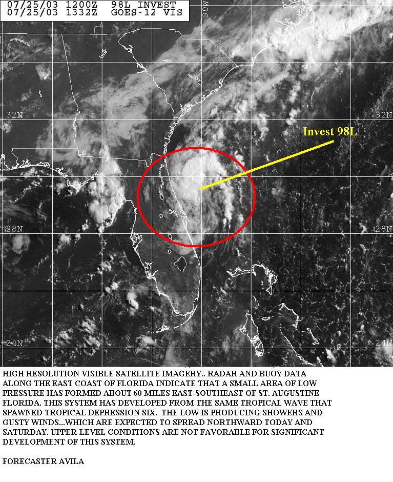
000
ABNT20 KNHC 251454
TWOAT
TROPICAL WEATHER OUTLOOK
NWS TPC/NATIONAL HURRICANE CENTER MIAMI FL
1130 AM EDT FRI JUL 25 2003
FOR THE NORTH ATLANTIC...CARIBBEAN SEA AND THE GULF OF MEXICO...
SATELLITE IMAGERY AND SURFACE OBSERVATIONS INDICATE THAT A TROPICAL
DEPRESSION MAY BE FORMING IN THE SMALL AREA OF LOW PRESSURE LOCATED
ABOUT 50 MILES EAST-SOUTHEAST OF ST. AUGUSTINE FLORIDA...AND
ADVISORIES MAY BE REQUIRED LATER TODAY. ALTHOUGH NO SIGNIFICANT
STRENGTHENING IS ANTICIPATED...THIS SYSTEM WILL BRING SHOWERS AND
GUSTY WINDS PRIMARILY TO PORTIONS OF THE SOUTHEAST GEORGIA AND
SOUTH CAROLINA LATER TODAY AS IT MOVES NORTHWARD. THE AIR FORCE
RESERVE UNIT IS PREPARING TO QUICKLY DISPATCH A RECONNAISSANCE
PLANE TO THE AREA THIS AFTERNOON.
ELSEWHERE...TROPICAL STORM FORMATION IS NOT EXPECTED THROUGH
SATURDAY.
FORECASTER AVILA/FRANKLIN
0 likes
-
cycloneye
- Admin
- Posts: 149744
- Age: 69
- Joined: Thu Oct 10, 2002 10:54 am
- Location: San Juan, Puerto Rico
That is very interesting language from them.
0 likes
Visit the Caribbean-Central America Weather Thread where you can find at first post web cams,radars
and observations from Caribbean basin members Click Here
and observations from Caribbean basin members Click Here


-
chadtm80
632
NOUS42 KNHC 251500
WEATHER RECONNAISSANCE FLIGHTS
CARCAH, TPC/NATIONAL HURRICANE CENTER, MIAMI,FL.
1100 AM EDT FRI 25 JULY 2003
SUBJECT: TROPICAL CYCLONE PLAN OF THE DAY (TCPOD)
VALID 26/1100Z TO 27/1100Z JUL 2003
TCPOD NUMBER.....03-055
I. ATLANTIC REQUIREMENTS
1. NEGATIVE RECONNAISSANCE REQUIREMENTS.
2. OUTLOOK FOR SUCCEEDING DAY....NEGATIVE.
3. NOTE:A RESOURCES PERMITTING INVEST MISSION WAS TASKED FOR
APPROX 25/1800Z ON SUSPECT AREA OFF THE EAST COAST OF FLORIDA
NEAR 30.8N AND 80.5W.
II. PACIFIC REQUIREMENTS
1. NEGATIVE RECONNAISSANCE REQUIREMENTS.
2. OUTLOOK.....NEGATIVE.
WVW
DATE/TIME LAT LON CLASSIFICATION STORM
25/1215 UTC 29.4N 80.1W T1.0/1.0 90 -- Atlantic Ocean
0 likes

Unless this system quicky exits NE now, it may get blocked and may be even forced west. Check position of Bermuda High on GFS at 18hrs!
http://www.nco.ncep.noaa.gov/pmb/nwprod ... 0_018s.gif
http://www.nco.ncep.noaa.gov/pmb/nwprod ... 0_018s.gif
0 likes
-
chadtm80

Here is a little more food for thought. Another trough will enter the east coast on Tuesday breaking down the ridge and allowing a more nort /nottheast turn if it hasn't dissipated inland some where.
http://www.nco.ncep.noaa.gov/pmb/nwprod ... 0_084s.gif
http://www.nco.ncep.noaa.gov/pmb/nwprod ... 0_084s.gif
0 likes

-
DROliver
-
Stephanie

- S2K Supporter

- Posts: 23843
- Age: 63
- Joined: Thu Feb 06, 2003 9:53 am
- Location: Glassboro, NJ
Tip wrote:Here is a little more food for thought. Another trough will enter the east coast on Tuesday breaking down the ridge and allowing a more nort /nottheast turn if it hasn't dissipated inland some where.
http://www.nco.ncep.noaa.gov/pmb/nwprod ... 0_084s.gif
I would think that since it's a long time between now and Tuesday that it would've made it onshore by then. It looks like it's headed due north. As Joe B. was saying, he thinks that it's going to be trapped...would that mean the storm would be trapped by the Bermuda High and the trough?
0 likes
Who is online
Users browsing this forum: No registered users and 125 guests