Southern Plains winter wx thread (2008-2009)

Winter Weather Discussion

Moderator: S2k Moderators

Forum rules

The posts in this forum are NOT official forecast and should not be used as such. They are just the opinion of the poster and may or may not be backed by sound meteorological data. They are NOT endorsed by any professional institution or STORM2K.

Help Support Storm2K
Message
Author
Ed Mahmoud

Re: Cold pattern on the way?

#261 Postby Ed Mahmoud » Wed Dec 03, 2008 8:47 pm

srainhoutx wrote:
zaqxsw75050 wrote:Actually, wxman57 is on another forum (non s2k) in winter time.


Yeah, wxman57 likes to keep it "local" during the winter. We know how much he hates the anything below 85 degrees. :lol:


Channel 11 forum can be awfully slow at times...
0 likes   

User avatar
Extremeweatherguy
Category 5
Category 5
Posts: 11095
Joined: Mon Oct 10, 2005 8:13 pm
Location: Florida

#262 Postby Extremeweatherguy » Wed Dec 03, 2008 9:38 pm

Speaking of wxman57, here is a very interesting statement he made tonight on that other
forum people have been mentioning...

wxman57 wrote:
Biggerbyte wrote:I'd shoot for middle December, through middle January for anything such as this for s.e. Texas. After that, probably much more seasonable. All of this is nothing more than speculation based on what we see now. I've never liked long-range forecasting. Hurricane season is no exception, and only goes toward showing how off they can be. Let's look at it again seven days out.


There are actually things that are happening right now that give clues, we don't have to wait for a few days. The cold air is building in Siberia and the pattern is developing that will transport it across the Pole in the next 10 days. The current flow pattern around the Polar region is quite similar to major Arctic outbreaks of the past, 1989 in particular. So there are strong signs of a major event, but it's impossible to tell the specifics as far as temps, precip, and timing so far out. It'll be before January, almost certainly. Probably the week before Christmas.
Last edited by Extremeweatherguy on Wed Dec 03, 2008 9:40 pm, edited 1 time in total.
0 likes   

User avatar
hriverajr
Professional-Met
Professional-Met
Posts: 786
Joined: Tue Jul 19, 2005 12:16 am

Re: Cold pattern on the way?

#263 Postby hriverajr » Wed Dec 03, 2008 9:40 pm

This is what weatherman is saying on the khou forum.. some of your ears will perk up, to quote-

"There are actually things that are happening right now that give clues, we don't have to wait for a few days. The cold air is building in Siberia and the pattern is developing that will transport it across the Pole in the next 10 days. The current flow pattern around the Polar region is quite similar to major Arctic outbreaks of the past, 1989 in particular. So there are strong signs of a major event, but it's impossible to tell the specifics as far as temps, precip, and timing so far out. It'll be before January, almost certainly. Probably the week before Christmas. -wxman 57"


and you know how he hates cold weather :)

I see someone beat me to it...
0 likes   

jinftl
Category 5
Category 5
Posts: 4312
Joined: Tue Aug 31, 2004 4:47 pm
Location: fort lauderdale, fl

Re: Cold pattern on the way?

#264 Postby jinftl » Wed Dec 03, 2008 10:03 pm

This looks like it could be one of the most hyped arctic invasions this board has seen in quite some time...this could end up as the 'call of the year' or a big 'oops'. In all fairness, it usually is kind of cold in siberia this time of year...and cold air does build up there during an event called 'winter'...but that said, I am more than open to the possibility. There will need to be more than a 2-week model run to really 'seal the deal'. Not to mention, some appreciable snowcover from the canadian border south would be needed...something we are well behind compared to the same dates in 2007 & 2006 (http://www.nohrsc.noaa.gov/nsa/).

More than anything, I really do hope folks get the winter weather they desire without that same weather resulting in economic losses to agriculture in areas like south texas and florida, without farmers losing their crops and, therefore, their livelihood, without causing heating and oil bills to skyrocket during these economic times when many can barely pay their bills as is, and without causing travel nightmares for those who are able to visit family and loved ones this holiday season. The arctic invasions some (not all) are salivating over, can be much more damaging in terms of dollars and hardship than hurricanes.

Other than all that, i say, bring it on!!! After all time is of the essence....winter enthusiasts don't get the long season hurricane trackers do...10 weeks or so and we will be speculating on when springtime weather will be returning!!!

hriverajr wrote:This is what weatherman is saying on the khou forum.. some of your ears will perk up, to quote-

"There are actually things that are happening right now that give clues, we don't have to wait for a few days. The cold air is building in Siberia and the pattern is developing that will transport it across the Pole in the next 10 days. The current flow pattern around the Polar region is quite similar to major Arctic outbreaks of the past, 1989 in particular. So there are strong signs of a major event, but it's impossible to tell the specifics as far as temps, precip, and timing so far out. It'll be before January, almost certainly. Probably the week before Christmas. -wxman 57"


and you know how he hates cold weather :)

I see someone beat me to it...
Last edited by jinftl on Wed Dec 03, 2008 10:04 pm, edited 1 time in total.
0 likes   

User avatar
srainhoutx
S2K Supporter
S2K Supporter
Posts: 6919
Age: 67
Joined: Sun Jan 14, 2007 11:34 am
Location: Haywood County, NC
Contact:

Re: Cold pattern on the way?

#265 Postby srainhoutx » Wed Dec 03, 2008 10:04 pm

hriverajr wrote:This is what weatherman is saying on the khou forum.. some of your ears will perk up, to quote-

"There are actually things that are happening right now that give clues, we don't have to wait for a few days. The cold air is building in Siberia and the pattern is developing that will transport it across the Pole in the next 10 days. The current flow pattern around the Polar region is quite similar to major Arctic outbreaks of the past, 1989 in particular. So there are strong signs of a major event, but it's impossible to tell the specifics as far as temps, precip, and timing so far out. It'll be before January, almost certainly. Probably the week before Christmas. -wxman 57"


and you know how he hates cold weather :)

I see someone beat me to it...


And do we know :ggreen:
0 likes   

User avatar
zaqxsw75050
Tropical Storm
Tropical Storm
Posts: 178
Joined: Thu Mar 06, 2008 4:21 pm
Location: Hong Kong

Re: Cold pattern on the way?

#266 Postby zaqxsw75050 » Wed Dec 03, 2008 10:26 pm

wow, that's something to keep an eye on if wxman said that.
0 likes   

User avatar
Extremeweatherguy
Category 5
Category 5
Posts: 11095
Joined: Mon Oct 10, 2005 8:13 pm
Location: Florida

#267 Postby Extremeweatherguy » Wed Dec 03, 2008 11:22 pm

00z GFS continues to show a little bit of winter weather in Oklahoma next Tuesday on the back side of a low...

132 hrs - Tues. morning
http://www.nco.ncep.noaa.gov/pmb/nwprod ... p_132l.gif


This makes 3 runs in a row that it has shown the possibility of winter precipitation early next week. Unfortunately, it looks to be a brief and fairly light occurrence, probably not amounting to anything more than a dusting of snow or sleet (if even).

----------------------------------------------------------------------------

Right behind this little event comes something even more interesting..

By hour 156, the GFS is driving a shot of canadian air down the plains with snow flying in Kansas and Nebraska on Wednesday morning: http://www.nco.ncep.noaa.gov/pmb/nwprod ... n_156l.gif

By hour 162 (Wednesday afternoon), this classic blue-norther is pushing into Oklahoma. Afternoon temperatures in OKC will likely fall below freezing as the front passes: http://www.nco.ncep.noaa.gov/pmb/nwprod ... n_162l.gif

The cold airmass then pushes into central/NE Texas by hour 174 before trying to stall out (which is a classic GFS error with this kind of airmass in the long range): http://www.nco.ncep.noaa.gov/pmb/nwprod ... n_174l.gif

For the most part, this model run takes most of the coldest air east of the plains, but it has started to gradually shift back westward with the cold in recent runs. Also, as we all know, the GFS doesn't always do too well with this kind of airmass in the long range. It is biased toward stalling cold in the southern plains, which typically doesn't happen. If we assume the same error is being made here, then it is safe to say that Oklahoma and Texas could be in for some of their coldest readings of the year come mid next week. Also, if you are in the east, then I would watch this one very closely as well. If this model run is right, then you guys could be in for bitter cold air, including the possibility of sub-zero readings in parts of the Ohio valley! :eek: Brrr...

-----------------------------------------------------------------------------------

And then behind the above event comes something even more interesting (lol!)...

This is now considered to be the long range, and not as accurate, but we will look at it anyway.

At hour 216, another arctic airmass is plunging southward and meeting up with moisture. Winter precipitation is the result across the plains: http://www.nco.ncep.noaa.gov/pmb/nwprod ... n_216l.gif

By hour 228, the winter precipitation reaches Texas: http://www.nco.ncep.noaa.gov/pmb/nwprod ... n_228l.gif

The winter precipitation then continues in the southern plains through hour 252. At the same time, the east coast is also getting slammed: http://www.nco.ncep.noaa.gov/pmb/nwprod ... n_252l.gif


-----------------------------------------------------------------------------------

Overall, this is one very exciting (and cold) GFS run! :) :cold:
Last edited by Extremeweatherguy on Wed Dec 03, 2008 11:59 pm, edited 6 times in total.
0 likes   

User avatar
iorange55
Category 5
Category 5
Posts: 2388
Joined: Thu Nov 13, 2008 9:47 pm
Location: Big D

Re: Cold pattern on the way?

#268 Postby iorange55 » Wed Dec 03, 2008 11:32 pm

Going by the new run of the GFS 00 it sure is looking pretty chilly next week.
0 likes   

Ed Mahmoud

Re: Cold pattern on the way?

#269 Postby Ed Mahmoud » Thu Dec 04, 2008 7:39 am

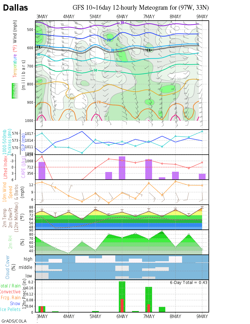
Maybe enough ice/snow to cancel school in Dallas, maybe not. (hot linked image will change about Noon)

Image
0 likes   

User avatar
iorange55
Category 5
Category 5
Posts: 2388
Joined: Thu Nov 13, 2008 9:47 pm
Location: Big D

Re: Cold pattern on the way?

#270 Postby iorange55 » Thu Dec 04, 2008 8:21 am

With all that's going on I hope we see some type of wintry precip in December.
0 likes   

User avatar
Extremeweatherguy
Category 5
Category 5
Posts: 11095
Joined: Mon Oct 10, 2005 8:13 pm
Location: Florida

#271 Postby Extremeweatherguy » Thu Dec 04, 2008 9:13 am

The 6z GFS continues to be quite cold. It still shows some winter weather in Oklahoma early next week, followed by the potential of our coldest high of the season (below freezing?) by next Thursday. According to wxman57 however, the cold for next week will not be the "big one". He thinks the coldest shot of arctic air is still at least 12-14 days away and that next week's events will just be typical wintertime canadian airmasses (a.k.a still cold, but not as brutal as what may follow the week after).
0 likes   

User avatar
srainhoutx
S2K Supporter
S2K Supporter
Posts: 6919
Age: 67
Joined: Sun Jan 14, 2007 11:34 am
Location: Haywood County, NC
Contact:

Re:

#272 Postby srainhoutx » Thu Dec 04, 2008 9:24 am

Extremeweatherguy wrote:The 6z GFS continues to be quite cold. It still shows some winter weather in Oklahoma early next week, followed by the potential of our coldest high of the season (below freezing?) by next Thursday. According to wxman57 however, the cold for next week will not be the "big one". He thinks the coldest shot of arctic air is still at least 12-14 days away and that next week's events will just be typical wintertime canadian airmasses (a.k.a still cold, but not as brutal as what may follow the week after).


Good thing about next week's system is the potential for some snow cover which will aid in a less "modified airmass" when the "big one" drops down into the Lower 48. Looks as if the stage is being set. We shall see.
0 likes   

User avatar
Extremeweatherguy
Category 5
Category 5
Posts: 11095
Joined: Mon Oct 10, 2005 8:13 pm
Location: Florida

#273 Postby Extremeweatherguy » Thu Dec 04, 2008 11:14 am

The 12z GFS continues to look pretty favorable for winter precipitation in Oklahoma early next week...

120 HRS
http://www.nco.ncep.noaa.gov/pmb/nwprod ... n_120l.gif
http://www.nco.ncep.noaa.gov/pmb/nwprod ... p_120l.gif

126 HRS
http://www.nco.ncep.noaa.gov/pmb/nwprod ... n_126l.gif
http://www.nco.ncep.noaa.gov/pmb/nwprod ... p_126l.gif

Surface temperatures will be just above freezing, but the upper levels will be cold enough to support a changeover to sleet and snow across most of the state. A quick dusting appears possible before the low scoots off to the east Tuesday afternoon.


This run is then more in line with the ECMWF in the longer range. It holds back on the arctic air dump next Wed/Thurs that earlier GFS runs were showing, and instead keeps most of the coldest air bottled up in southern Canada. This cold air is then released later on in the form of a series of fronts next weekend through the week before Christmas.
Last edited by Extremeweatherguy on Thu Dec 04, 2008 11:45 am, edited 1 time in total.
0 likes   

User avatar
gboudx
S2K Supporter
S2K Supporter
Posts: 4080
Joined: Thu Sep 04, 2003 1:39 pm
Location: Rockwall, Tx but from Harvey, La

#274 Postby gboudx » Thu Dec 04, 2008 11:26 am

In respects to wxman57's comments, what is the timeframe he's referring to?
0 likes   

Ed Mahmoud

Re:

#275 Postby Ed Mahmoud » Thu Dec 04, 2008 11:40 am

gboudx wrote:In respects to wxman57's comments, what is the timeframe he's referring to?


Ten to fifteen days per the KHOU forum, which has annoying and frequent pop-ups.
0 likes   

User avatar
vbhoutex
Storm2k Executive
Storm2k Executive
Posts: 29112
Age: 73
Joined: Wed Oct 09, 2002 11:31 pm
Location: Cypress, TX
Contact:

Re: Re:

#276 Postby vbhoutex » Thu Dec 04, 2008 11:44 am

srainhoutx wrote:
Extremeweatherguy wrote:The 6z GFS continues to be quite cold. It still shows some winter weather in Oklahoma early next week, followed by the potential of our coldest high of the season (below freezing?) by next Thursday. According to wxman57 however, the cold for next week will not be the "big one". He thinks the coldest shot of arctic air is still at least 12-14 days away and that next week's events will just be typical wintertime canadian airmasses (a.k.a still cold, but not as brutal as what may follow the week after).


Good thing about next week's system is the potential for some snow cover which will aid in a less "modified airmass" when the "big one" drops down into the Lower 48. Looks as if the stage is being set. We shall see.


This pattern that is setting up is becoming almost a deja-vu experience for me. What we are seeing is VERY similar to how the weather was in Winter 1989 here in Houston. Colder and colder shots coming down the pike every few days or so with milder in between and then HERE CAME THE ARCTIC along with overrunning from a GOM low(iirc) to produce our winter precip. As stated, we shall see.
0 likes   

Valkhorn
Category 1
Category 1
Posts: 492
Joined: Wed Sep 10, 2003 4:09 am
Contact:

#277 Postby Valkhorn » Thu Dec 04, 2008 11:52 am

1989 wasn't as cold for us in Knoxville as other blasts. We only got down to 0 for that one and we only had about an inch or two of snow on the ground.

I'd take January 1985 over December 1989 :)

On Jan 21, 1985 we had a low of -24 and a high of 6 with 7 inches on the ground.
0 likes   

User avatar
srainhoutx
S2K Supporter
S2K Supporter
Posts: 6919
Age: 67
Joined: Sun Jan 14, 2007 11:34 am
Location: Haywood County, NC
Contact:

Re: Re:

#278 Postby srainhoutx » Thu Dec 04, 2008 11:57 am

vbhoutex wrote:
srainhoutx wrote:
Extremeweatherguy wrote:The 6z GFS continues to be quite cold. It still shows some winter weather in Oklahoma early next week, followed by the potential of our coldest high of the season (below freezing?) by next Thursday. According to wxman57 however, the cold for next week will not be the "big one". He thinks the coldest shot of arctic air is still at least 12-14 days away and that next week's events will just be typical wintertime canadian airmasses (a.k.a still cold, but not as brutal as what may follow the week after).


Good thing about next week's system is the potential for some snow cover which will aid in a less "modified airmass" when the "big one" drops down into the Lower 48. Looks as if the stage is being set. We shall see.


This pattern that is setting up is becoming almost a deja-vu experience for me. What we are seeing is VERY similar to how the weather was in Winter 1989 here in Houston. Colder and colder shots coming down the pike every few days or so with milder in between and then HERE CAME THE ARCTIC along with overrunning from a GOM low(iirc) to produce our winter precip. As stated, we shall see.


I hear you vbhoutex. Frozen pipes at Christmas was no fun and a house full of sick "out of town" company that brought a nasty flu bug with them in 1989. I still remember the frozen fire hydrants we had to contend with that year and fires everywhere along with rolling black outs.
0 likes   

Ed Mahmoud

Re: Cold pattern on the way?

#279 Postby Ed Mahmoud » Thu Dec 04, 2008 12:03 pm

Just snow flurries in Austin, but IIRC it got down to something like 14ºF in 1989.


Double Post, but my techniques for amatuer guessing of winter precip. For long range cold predicition, I tend to defer to Joe Bastardi and medium range synoptic experts, and now that I have dragged WxMan57 back away from the site crawling with annoying pop-ups, him. I'm trying to apply what little I know about the polar vortex, the McFarland signature, and temps and pressures in Alaska and the Yukon. I haven't had much luck finding an abundance of temps/pressures in Siberia, so I just take someone's word for it when they say cold air is building there.

...........................................................................

My AccuWx PPV GFS machine output for specific cities gives 2 meter, 1000-500 thickness, 850 mb temps, and precip, but the precip is for the previous six hours, so I usually do a rough mental interpolation of how much precip occured in the prior six hours time frame and the 850 and surface temps and thickness to the one in question, and the subsequent six hour time frame, to guess whether precip is predicted after the magic temps/thicknesses are reached.

Inside 84 hours, the PSU e-Wall has 3 hour increments, and draws in magic 1000-500 and 1000-700 thicknesses, and 850 mb temps for the WRF and GFS models. The Northeast floater (it is Penn State, after all) even draws in surface temps, great for prediciting potential icing.

For the Plains/Texas, I have to guess at icing from the e-Wall by looking for spreads between the magic thicknesses, and the 850 mb freezing line, and then pick a city, (if it is an obscure city, use the weather.noaa.gov website to find the current conditions, and more importantly, the 3 letter airport code, and feed it to the AccuWx MOS generator, to see if it indeed seems to be predicting icing.


No fancy workstations for an amateur like me, just the World Wide Internet.
0 likes   

User avatar
Portastorm
Storm2k Moderator
Storm2k Moderator
Posts: 9914
Age: 63
Joined: Fri Jul 11, 2003 9:16 am
Location: Round Rock, TX
Contact:

Re: Cold pattern on the way?

#280 Postby Portastorm » Thu Dec 04, 2008 12:12 pm

I remember single digits in Austin during that 1989 December Arctic blast. As someone who grew up in northeastern Ohio and was so happy to get out of winter-land, I couldn't believe it would ever get that cold in Austin, Texas. My then girlfriend (now wife) was laughing at how much of a weenie I was when I complained about the cold those few days. That was amazing. And I really prefer a 30-degree, ice/snow event over single digit cold outbreak, thankyouverymuch. :wink:
0 likes   


Return to “Winter Weather”

Who is online

Users browsing this forum: No registered users and 11 guests