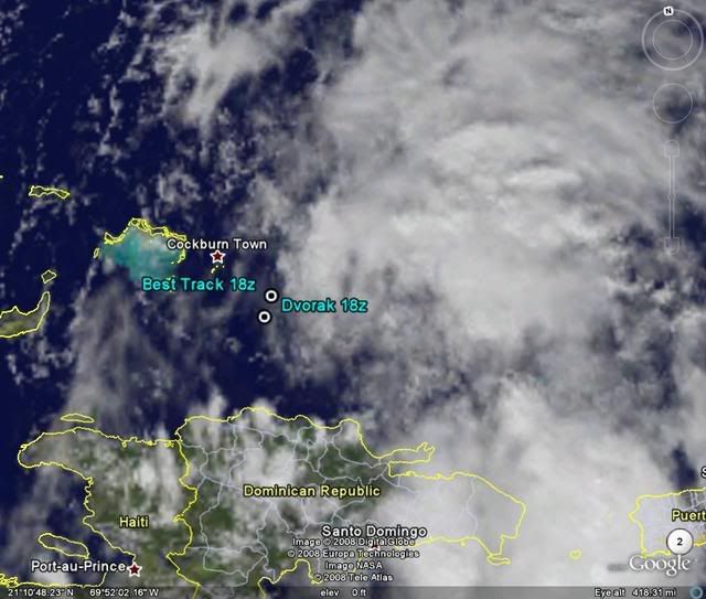
18:00 UTC Best Track.
AL, 93, 2008092418, , BEST, 0, 210N, 706W, 30, 1006, DB
ATL: Tropical Storm Kyle : Discussion
Moderator: S2k Moderators
-
cycloneye

- Admin

- Posts: 149283
- Age: 69
- Joined: Thu Oct 10, 2002 10:54 am
- Location: San Juan, Puerto Rico
Re: ATL INVEST 93L: Discussion
0 likes
-
Ed Mahmoud
Re: ATL INVEST 93L: Discussion
Matt-hurricanewatcher wrote:It is dead!!! At least it would appear so...
Running a high fever, breathing rapid and shallow, pulse thready and weak. But not dead, yet.
0 likes


-
Ed Mahmoud
Re: ATL INVEST 93L: Discussion
Ed Mahmoud wrote:Matt-hurricanewatcher wrote:It is dead!!! At least it would appear so...
Running a high fever, breathing rapid and shallow, pulse thready and weak. But not dead, yet.
Deeper thunderstorms well removed from unimpressive low cloud swirl. Getting sicker, into a coma...
0 likes
-
Lowpressure

- S2K Supporter

- Posts: 2032
- Age: 59
- Joined: Sun Sep 14, 2003 9:17 am
- Location: Charlotte, North Carolina
Re: ATL INVEST 93L: Discussion
Ed Mahmoud wrote:Ed Mahmoud wrote:Matt-hurricanewatcher wrote:It is dead!!! At least it would appear so...
Running a high fever, breathing rapid and shallow, pulse thready and weak. But not dead, yet.
Deeper thunderstorms well removed from unimpressive low cloud swirl. Getting sicker, into a coma...
Once again, JB flames.
0 likes

-
Ed Mahmoud

-
Lowpressure
- S2K Supporter
- Posts: 2032
- Age: 59
- Joined: Sun Sep 14, 2003 9:17 am
- Location: Charlotte, North Carolina
Re: ATL INVEST 93L: Discussion
Starting to look a little better. More of the deeper convection developing.
0 likes
-
wxman57

- Moderator-Pro Met

- Posts: 23172
- Age: 68
- Joined: Sat Jun 21, 2003 8:06 pm
- Location: Houston, TX (southwest)
Re: ATL INVEST 93L: Discussion
93L is moving into a jet stream of shear now. Look at a WV loop. Bones is walking to the microphone...
0 likes
-
Ed Mahmoud
Re: ATL INVEST 93L: Discussion
Once again, JB flames.
JB has been pushing 94L a lot harder, and, just yesterday, NHC had this as a 'code red' area.
But whatever, if one chooses to be willfully ignorant.
0 likes

-
Matt-hurricanewatcher
Re: ATL INVEST 93L: Discussion
I agree wxman57. This system will be dead soon!
I would keep a eye on that gulf convection...
I would keep a eye on that gulf convection...
0 likes
-
HURAKAN

- Professional-Met

- Posts: 46084
- Age: 39
- Joined: Thu May 20, 2004 4:34 pm
- Location: Key West, FL
- Contact:
Re: ATL INVEST 93L: Discussion
TROPICAL WEATHER OUTLOOK
NWS TPC/NATIONAL HURRICANE CENTER MIAMI FL
800 PM EDT WED SEP 24 2008
FOR THE NORTH ATLANTIC...CARIBBEAN SEA AND THE GULF OF MEXICO...
1. A RECENTLY COMPLETED AIR FORCE RECONNAISSANCE MISSION ALONG WITH
SATELLITE IMAGERY INDICATE THE LOW PRESSURE SYSTEM CENTERED ABOUT
250 MILES SOUTHEAST OF WILMINGTON NORTH CAROLINA HAS NOT ACQUIRED
TROPICAL CHARACTERISTICS. THE DATA FROM THE AIRCRAFT ALSO SHOW
THAT THE STRONGEST WINDS ARE WELL REMOVED TO NORTH AND WEST AND ARE
LARGELY UNRELATED TO THE SMALL CIRCULATION SAMPLED BY THE AIRCRAFT.
THIS STRUCTURE IS MORE CHARACTERISTIC OF AN EXTRATROPICAL WEATHER
SYSTEM. HOWEVER...THERE IS STILL THE POTENTIAL FOR THIS SYSTEM TO
BECOME A TROPICAL OR SUBTROPICAL CYCLONE TONIGHT OR THURSDAY AS IT
DRIFTS WESTWARD. REGARDLESS OF WHETHER OR NOT THIS SYSTEM BECOMES
A TROPICAL OR SUBTROPICAL CYCLONE...STRONG WINDS...COASTAL
FLOODING...HIGH SURF...AND DANGEROUS RIP CURRENTS WILL CONTINUE
ALONG PORTIONS OF THE U.S. EAST COAST DURING THE NEXT COUPLE
OF DAYS. SEE STATEMENTS FROM LOCAL NATIONAL WEATHER SERVICE
FORECAST OFFICES AND HIGH SEAS FORECASTS ISSUED BY THE OCEAN
PREDICTION CENTER IN WASHINGTON D.C. FOR ADDITIONAL INFORMATION AND
WARNINGS.
 2. SHOWERS AND THUNDERSTORMS ASSOCIATED WITH THE BROAD AREA OF LOW
PRESSURE JUST EAST OF THE TURKS AND CAICOS ISLANDS...REMAIN
DISORGANIZED AND THE SYSTEM STILL LACKS A WELL-DEFINED
SURFACE CIRCULATION. UPPER-LEVEL WINDS ARE ONLY MARGINALLY
FAVORABLE FOR DEVELOPMENT OF THIS SYSTEM AS IT MOVES NORTHWARD OVER
THE NEXT COUPLE OF DAYS. THERE IS STILL THE POTENTIAL FOR HEAVY
RAINFALL AND LIFE-THREATENING FLASH FLOODS AND MUD SLIDES OVER
HISPANIOLA...PUERTO RICO...AND THE VIRGIN ISLANDS TONIGHT.
ELSEWHERE...TROPICAL CYCLONE FORMATION IS NOT EXPECTED DURING THE
NEXT 48 HOURS.
$$
FORECASTER RHOME
NWS TPC/NATIONAL HURRICANE CENTER MIAMI FL
800 PM EDT WED SEP 24 2008
FOR THE NORTH ATLANTIC...CARIBBEAN SEA AND THE GULF OF MEXICO...
1. A RECENTLY COMPLETED AIR FORCE RECONNAISSANCE MISSION ALONG WITH
SATELLITE IMAGERY INDICATE THE LOW PRESSURE SYSTEM CENTERED ABOUT
250 MILES SOUTHEAST OF WILMINGTON NORTH CAROLINA HAS NOT ACQUIRED
TROPICAL CHARACTERISTICS. THE DATA FROM THE AIRCRAFT ALSO SHOW
THAT THE STRONGEST WINDS ARE WELL REMOVED TO NORTH AND WEST AND ARE
LARGELY UNRELATED TO THE SMALL CIRCULATION SAMPLED BY THE AIRCRAFT.
THIS STRUCTURE IS MORE CHARACTERISTIC OF AN EXTRATROPICAL WEATHER
SYSTEM. HOWEVER...THERE IS STILL THE POTENTIAL FOR THIS SYSTEM TO
BECOME A TROPICAL OR SUBTROPICAL CYCLONE TONIGHT OR THURSDAY AS IT
DRIFTS WESTWARD. REGARDLESS OF WHETHER OR NOT THIS SYSTEM BECOMES
A TROPICAL OR SUBTROPICAL CYCLONE...STRONG WINDS...COASTAL
FLOODING...HIGH SURF...AND DANGEROUS RIP CURRENTS WILL CONTINUE
ALONG PORTIONS OF THE U.S. EAST COAST DURING THE NEXT COUPLE
OF DAYS. SEE STATEMENTS FROM LOCAL NATIONAL WEATHER SERVICE
FORECAST OFFICES AND HIGH SEAS FORECASTS ISSUED BY THE OCEAN
PREDICTION CENTER IN WASHINGTON D.C. FOR ADDITIONAL INFORMATION AND
WARNINGS.
PRESSURE JUST EAST OF THE TURKS AND CAICOS ISLANDS...REMAIN
DISORGANIZED AND THE SYSTEM STILL LACKS A WELL-DEFINED
SURFACE CIRCULATION. UPPER-LEVEL WINDS ARE ONLY MARGINALLY
FAVORABLE FOR DEVELOPMENT OF THIS SYSTEM AS IT MOVES NORTHWARD OVER
THE NEXT COUPLE OF DAYS. THERE IS STILL THE POTENTIAL FOR HEAVY
RAINFALL AND LIFE-THREATENING FLASH FLOODS AND MUD SLIDES OVER
HISPANIOLA...PUERTO RICO...AND THE VIRGIN ISLANDS TONIGHT.
ELSEWHERE...TROPICAL CYCLONE FORMATION IS NOT EXPECTED DURING THE
NEXT 48 HOURS.
$$
FORECASTER RHOME
0 likes
-
HURAKAN
- Professional-Met
- Posts: 46084
- Age: 39
- Joined: Thu May 20, 2004 4:34 pm
- Location: Key West, FL
- Contact:
Re:
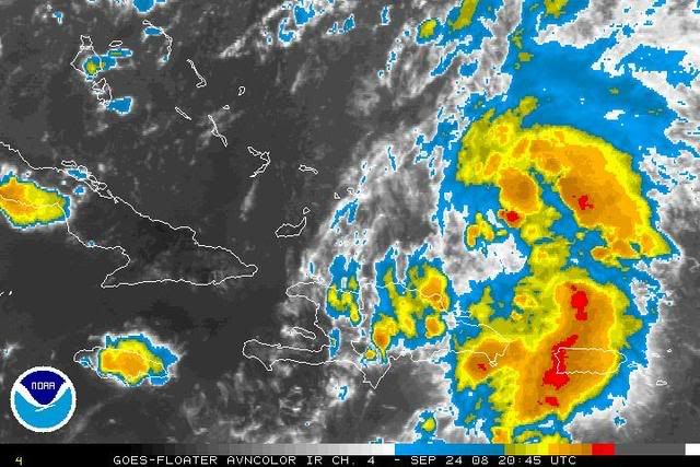
CrazyC83 wrote:Looking at the flight pattern graphic, it might just have an LLC, even if convection is lacking...
If it has a defined LLC, then it may be upgraded. I remember that Arlene was not very pretty when it was upgraded but it had a defined LLC.
0 likes
-
CrazyC83
- Professional-Met
- Posts: 34315
- Joined: Tue Mar 07, 2006 11:57 pm
- Location: Deep South, for the first time!
Re: Re:
HURAKAN wrote:CrazyC83 wrote:Looking at the flight pattern graphic, it might just have an LLC, even if convection is lacking...
If it has a defined LLC, then it may be upgraded. I remember that Arlene was not very pretty when it was upgraded but it had a defined LLC.
Even with so little deep convection?
0 likes

-
Matt-hurricanewatcher
Re: Re:
HURAKAN wrote:CrazyC83 wrote:Even with so little deep convection?
When Arlene became a TS:
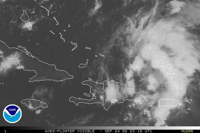
93L:
[img]
http://i40.photobucket.com/albums/e244/ ... LE/vis.jpg[/img]
Even if it has a well defined LLC, the nhc is going to went deep convection to form over it before they upgrade. So no upgrade tonight,,,then by tomarrow afternoon it will be sheared to death.
0 likes
Who is online
Users browsing this forum: No registered users and 39 guests