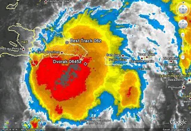
cycloneye wrote:Another big batch of rain enters Puerto Rico that doesnt need anymore.
ATL: Tropical Storm Kyle : Discussion
Moderator: S2k Moderators
-
canetracker

- S2K Supporter

- Posts: 751
- Age: 63
- Joined: Wed Jul 27, 2005 8:49 pm
- Location: Suburbia New Orleans...Harahan, LA
Re: ATL: INVEST 93L: Discussion

0 likes


-
cycloneye

- Admin

- Posts: 149291
- Age: 69
- Joined: Thu Oct 10, 2002 10:54 am
- Location: San Juan, Puerto Rico
Re: ATL: INVEST 93L: Discussion
canetracker wrote:cycloneye wrote:Another big batch of rain enters Puerto Rico that doesnt need anymore.. Do you know the highest rainfall totals so far? I heard 20+ inches.
A new record amount was set in the past 24 hours in the town of Patillas,in SE PR.24 inches in 24 hours.

0 likes
-
canetracker
- S2K Supporter
- Posts: 751
- Age: 63
- Joined: Wed Jul 27, 2005 8:49 pm
- Location: Suburbia New Orleans...Harahan, LA
Re: ATL: INVEST 93L: Discussion
2 feet of rain in 24 hrs! I'd hate to see 93L really develop into a TD or TS. As a strong wave it is bad enough.
http://www.cnn.com/2008/WORLD/americas/09/22/caribbean.storm.ap/index.html?section=cnn_latest
Gov. Anibal Acevedo Vila said more than 2 feet (0.61 meters) of water fell in 24 hours in Patillas county in southeastern Puerto Rico. He warned that 12 more inches of rain could fall in the next 24 hours.
http://www.cnn.com/2008/WORLD/americas/09/22/caribbean.storm.ap/index.html?section=cnn_latest
0 likes
-
canetracker
- S2K Supporter
- Posts: 751
- Age: 63
- Joined: Wed Jul 27, 2005 8:49 pm
- Location: Suburbia New Orleans...Harahan, LA
Re: ATL: INVEST 93L: Discussion

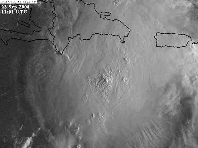
Convection looks to be consolidating over eastern DR?
Another view: http://www.ssd.noaa.gov/goes/flt/t1/loop-rb.html
0 likes

Re: ATL: INVEST 93L: Discussion
Year of the Hispaniola huggers.
The developing center is over Hispaniola which is why the well-developed convection isn't showing a clear center.
We'll see when it emerges north of Hispaniola how quickly it jumps into the expected N track.
The developing center is over Hispaniola which is why the well-developed convection isn't showing a clear center.
We'll see when it emerges north of Hispaniola how quickly it jumps into the expected N track.
0 likes

Re: ATL: INVEST 93L: Discussion
Defintely not a well trained eye here, but I do believe it's starting to wrap up -- or the convective banding is deceptive as far as a low center is concerned.
0 likes
-
cycloneye
- Admin
- Posts: 149291
- Age: 69
- Joined: Thu Oct 10, 2002 10:54 am
- Location: San Juan, Puerto Rico
Re: ATL: INVEST 93L: Discussion
000
WONT41 KNHC 230232
DSAAT
SPECIAL TROPICAL DISTURBANCE STATEMENT
NWS TPC/NATIONAL HURRICANE CENTER MIAMI FL
1030 PM EDT MON SEP 22 2008
THE BROAD LOW PRESSURE AREA LOCATED OVER THE EASTERN DOMINICAN
REPUBLIC IS CURRENTLY MOVING SLOWLY WEST-NORTHWESTWARD. THE SYSTEM
HAS CHANGED LITTLE IN ORGANIZATION DURING THE PAST SEVERAL HOURS.
HOWEVER...UPPER-LEVEL WINDS ARE BECOMING SOMEWHAT MORE FAVORABLE
FOR DEVELOPMENT...AND THE CENTER OF THE LOW IS EXPECTED TO MOVE
NORTHWESTWARD INTO THE ATLANTIC NORTH OF THE ISLAND OF HISPANIOLA
DURING THE NEXT 24 HOURS OR SO. THEREFORE...THIS SYSTEM COULD
BECOME A TROPICAL DEPRESSION AT ANY TIME DURING THE NEXT COUPLE OF
DAYS. REGARDLESS OF WHETHER OR NOT THIS SYSTEM BECOMES A
TROPICAL DEPRESSION...IT WILL CONTINUE TO PRODUCE VERY HEAVY
RAINFALL OVER PUERTO RICO...THE U.S. AND BRITISH VIRGIN ISLANDS...
AND THE DOMINICAN REPUBLIC THROUGH TUESDAY. THESE RAINS COULD
CAUSE LIFE-THREATENING FLASH FLOODS AND MUDSLIDES.
INTERESTS IN PUERTO RICO...THE U.S. AND BRITISH VIRGIN ISLANDS...THE
DOMINICAN REPUBLIC...HAITI...THE TURKS AND CAICOS ISLANDS...AND THE
SOUTHEASTERN BAHAMAS SHOULD CONTINUE TO MONITOR THE PROGRESS OF THIS
SYSTEM AND ANY PRODUCTS ISSUED BY THEIR RESPECTIVE WEATHER FORECAST
OFFICES.
$$
FORECASTER BEVEN
0 likes
Re: ATL: INVEST 93L: Discussion
Strange year for very good satellite presentation but no TD designation.
Hispaniola tracks.
Eyes while still a TS.
Hispaniola tracks.
Eyes while still a TS.
0 likes
Re: ATL: INVEST 93L: Discussion
I'll say one thing, anything developing in the Atlantic north of Hispaniola is definitely worth watching in Florida.
Not a forecast, prediction, wish or anything like it. I just know from years of tracking that the only clear shot at south florida is from that position. I haven't kept up with the developing features, but it's common sense that Sfla has to watch out for recurves from the Caribbean and westerly tracks through the Bahamas under a high. Climatologically, I doubt we're out of the woods as much as say, southern Texas might be at this point.
Correct me if I'm way off.
0 likes
-
canetracker
- S2K Supporter
- Posts: 751
- Age: 63
- Joined: Wed Jul 27, 2005 8:49 pm
- Location: Suburbia New Orleans...Harahan, LA
Re: ATL: INVEST 93L: Discussion
Recurve wrote:I'll say one thing, anything developing in the Atlantic north of Hispaniola is definitely worth watching in Florida.
Not a forecast, prediction, wish or anything like it. I just know from years of tracking that the only clear shot at south florida is from that position. I haven't kept up with the developing features, but it's common sense that Sfla has to watch out for recurves from the Caribbean and westerly tracks through the Bahamas under a high. Climatologically, I doubt we're out of the woods as much as say, southern Texas might be at this point.
Correct me if I'm way off.
....Not just Texas, but the GOM in general should be out the woods (based on current model projections). Looking past the devastation 93L is doing right now, do think this will be a east coast or out to sea storm. Hopefully, it will spare Haiti.
Not official and just my opinion.
0 likes
Re: ATL INVEST 93L: Discussion
If 93L does develop and moves north of NC/VA, the water temps drop off very quickly....any storm would have to be racing north to make landfall as a hurricane any where to the north....water temps are in the 60s for quite a distance south of even Long Island now....approaching the high 50s/low 60s off of Cape Cod....something Dr. Jeff Masters mentions in his latest blog update:
The intensity forecast
Wind shear is marginal for development, about 15-20 knots. Shear is forecast to drop to 5-10 knots Tuesday and Wednesday which should allow 93L to intensify into a 50-60 mph tropical storm. There is a window of opportunity for it to reach Category 1 hurricane strength before Friday, when it crosses north of Virginia (assuming it doesn't make landfall in North or South Carolina). Wind shear is forecast to increase to 15-20 knots and water temperatures will cool below 26°C on Friday, which should induce weakening.
0 likes
Re: ATL INVEST 93L: Discussion
So if 93L stays an open wave is there any chance that it misses the trough and continues to head west before developing?
0 likes
Re: ATL INVEST 93L: Discussion
Is 93L trying to organize se...or even south... of the dominican republic? Looks like Haiti unfortunately is going to get in on the rain unless convection wanes or a due north track commences. As an fyi, 36 hours ago, some of the best models showed 93L reaching 30N before getting as far west as 70W.

0 likes
-
AJC3

- Admin
- Posts: 4153
- Age: 62
- Joined: Tue Aug 31, 2004 7:04 pm
- Location: Ballston Spa, New York
- Contact:
Re: ATL INVEST 93L: Discussion
xironman wrote:So if 93L stays an open wave is there any chance that it misses the trough and continues to head west before developing?
Pretty soon whatever little westward progress 93L is now making will come to a grinding halt. If you look at watervapor imagery You can see the strong mid/upper level trough over the eastern CONUS dropping southward. All of the global model guidance shows the base of this trough cutting off into a closed low offshore the Carolinas by early Wednesday...then show the low retrograding southwestward into the SE CONUS between Wednesday and Friday. The steering currents north of
93L are already in the process of collapsing...and eventually 93L should turn north into increasing southerly flow between the cutoff and the ATLC ridge to the east. It's been reluctant to move northward thus far, owing to the fact that the model guidance has been too aggressive in spinning in up.
If it was to remain a weak disorganized mess instead of spinning up, I suppose it might be a bit slower to turn north, however the shallow layer BAM is not very far apart from the medium and deep layer BAM throughout the next five days. This means that the steering currents at all layers are eventually pointing toward a northward motion.
With the upper low in the process of cutting off, it's just a matter of time until a surface low begins to spin up offshore the southeast US coast...so there isn't even going to be a low level ridge north of 93L ...only deep layer southerly flow.
0 likes
-
HURAKAN

- Professional-Met

- Posts: 46084
- Age: 39
- Joined: Thu May 20, 2004 4:34 pm
- Location: Key West, FL
- Contact:
970
ABNT20 KNHC 230553
TWOAT
TROPICAL WEATHER OUTLOOK
NWS TPC/NATIONAL HURRICANE CENTER MIAMI FL
200 AM EDT TUE SEP 23 2008
FOR THE NORTH ATLANTIC...CARIBBEAN SEA AND THE GULF OF MEXICO...
A BROAD AREA OF LOW PRESSURE CENTERED OVER THE EASTERN DOMINICAN
REPUBLIC CONTINUES TO PRODUCE HEAVY RAINS OVER PORTIONS OF THE
EASTERN DOMINICAN REPUBLIC...PUERTO RICO...AND THE U.S. AND BRITISH
VIRGIN ISLANDS. THIS SYSTEM HAS CHANGED LITTLE IN ORGANIZATION
DURING THE PAST SEVERAL HOURS. HOWEVER...UPPER-LEVEL WINDS ARE
EXPECTED TO BECOME A LITTLE MORE CONDUCIVE FOR DEVELOPMENT AND THIS
SYSTEM HAS THE POTENTIAL TO BECOME A TROPICAL DEPRESSION AT ANY
TIME DURING THE NEXT DAY OR TWO AS IT MOVES NORTHWESTWARD AWAY
FROM HISPANIOLA. HEAVY RAINFALL WITH POTENTIALLY LIFE-THREATENING
FLASH FLOODING IS EXPECTED TO CONTINUE OVER THE AREA THROUGH EARLY
WEDNESDAY. INTERESTS IN PUERTO RICO...THE VIRGIN ISLANDS...
HISPANIOLA...THE TURKS AND CAICOS ISLANDS...AND THE SOUTHEASTERN
BAHAMAS SHOULD CONTINUE TO MONITOR THE PROGRESS OF THIS SYSTEM AND
PRODUCTS ISSUED BY THEIR LOCAL WEATHER FORECAST OFFICES.
ELSEWHERE...TROPICAL CYCLONE FORMATION IS NOT EXPECTED DURING THE
NEXT 48 HOURS.
$$
FORECASTER BROWN
0 likes
-
Lowpressure

- S2K Supporter
- Posts: 2032
- Age: 59
- Joined: Sun Sep 14, 2003 9:17 am
- Location: Charlotte, North Carolina
Re: ATL INVEST 93L: Discussion
Interesting location and higher Dvorak numbers. Recon might be flying around a large area later today to figure this out. For what it is worth, it looks better with center over water. Models are going to hate this more southerly location, but north movement still almost a must soon.
0 likes

Who is online
Users browsing this forum: No registered users and 8 guests