ATL: Tropical Storm Kyle : Discussion
Moderator: S2k Moderators
Re: ATL: INVEST 93L - Discussion
Thnk's for the correction,Luis and stay safe the next 24 hours or so.
0 likes
-
orion

- S2K Supporter

- Posts: 165
- Joined: Mon Aug 02, 2004 5:44 pm
- Location: Indian Harbour Beach, FL
- Contact:
Re: ATL: INVEST 93L - Discussion
I was just looking at some of the model runs from http://moe.met.fsu.edu/tcgengifs/ and it looks interesting when (if) 93L gets near the coast: UKMet shows a low forming near the Georgia coast as 93L fizzles, nogaps doesn't show any other low, but has 93L heading for the SC/NC border, mm5fsu-merge (I don't really know anything about this model- biases, etc.) shows 93L splitting and one part heading into Georgia and other toward Virginia coast, hwrf looks to be heading to NC/VA border but looks like it elongates southwestward down the coast, and gfs and cmc both show a low popping up in that area and heading west as 93L stays just off the coast.
Is this secondary low they are seeing the system wxman mentioned he believes 93L may merge with? And what effect (if 93L makes it that far) will this likely have on the track - if they merge, what is the likely outcome and if they do not merge, what is the likely outcome?
Is this secondary low they are seeing the system wxman mentioned he believes 93L may merge with? And what effect (if 93L makes it that far) will this likely have on the track - if they merge, what is the likely outcome and if they do not merge, what is the likely outcome?
0 likes


Re: ATL: INVEST 93L - Discussion
From Dr. Jeff Master's blog from this morning:
The intensity forecast
Wind shear is forecast to remain 10-20 knots over the next five days, and four of the six reliable forecast models predict that 93L will develop into a tropical depression by Tuesday. The GFDL and HWRF models predict 93L will strengthen into a hurricane by Friday. However, there will be high wind shear very close to 93L for the next five days, and the storm may struggle at times with this high shear. Water temperatures are a warm 29.5°C and ocean heat content will be moderate to high over the next five days. The NHC is giving 93L a high (>50% chance) of developing into a tropical depression by Tuesday. A Hurricane Hunter aircraft will investigate 93L this afternoon.
The track forecast
The models agree on a general north-northwesterly motion for 93L over the next 3-4 days, which would bring the storm just west of Bermuda. A major complicating factor in the long-range track forecast is the expected development of an extratropical Nor'easter storm off the coast of South Carolina on Thursday. The Nor'easter could bring hostile wind shear over 93L, weakening it into a subtropical storm. The Nor'easter might then recurve out to sea, drawing 93L behind it. This is the solution of the latest 06Z (2 am EDT) GFS model run. Alternatively, the two storms may rotate cyclonically around a common center (the Fujiwhara effect), sending the Nor'easter west-southwestward into the Southeast U.S., and 93L northwestwards towards North Carolina. This is the solution of the 00Z (8 pm EDT) GFDL model. The NOGAPS model predicts that the Nor'easter will not develop at all, and instead 93L will absorb the energy that would have gone into creating the Nor'easter. This would convert 93L into a hybrid subtropical storm that would affect the coast of North and South Carolina late this week with sustained winds in the 50-60 mph range. I don't have a good feel for what will happen in this complicated situation, but it currently appears that coastal North and South Carolina can expect tropical storm force winds from either an extratropical or tropical storm beginning on Friday. It is possible that 93L may impact the mid-Atlantic or New England regions early next week.
0 likes
-
cycloneye

- Admin

- Posts: 149841
- Age: 69
- Joined: Thu Oct 10, 2002 10:54 am
- Location: San Juan, Puerto Rico
Re: ATL: INVEST 93L - Discussion
A torrential thunderstorm here with winds that I went outside for a moment and I clocked in my anemometer 33 mph in gust.I dont know if I will have power for too long,so I you dont see me,you know why.

0 likes
-
HURAKAN

- Professional-Met

- Posts: 46084
- Age: 39
- Joined: Thu May 20, 2004 4:34 pm
- Location: Key West, FL
- Contact:
160
ABNT20 KNHC 212334
TWOAT
TROPICAL WEATHER OUTLOOK
NWS TPC/NATIONAL HURRICANE CENTER MIAMI FL
800 PM EDT SUN SEP 21 2008
FOR THE NORTH ATLANTIC...CARIBBEAN SEA AND THE GULF OF MEXICO...
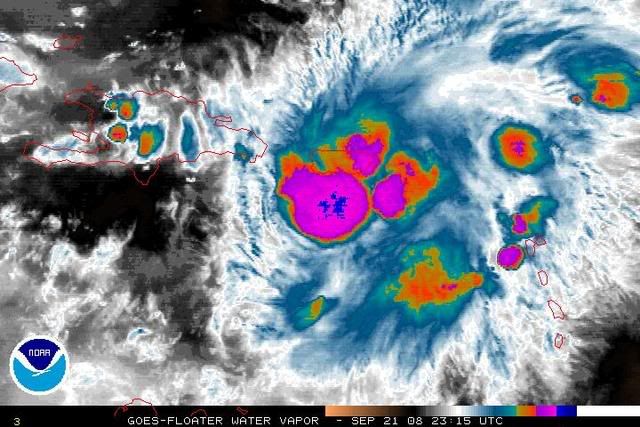
SATELLITE IMAGERY...RADAR DATA...AND SURFACE OBSERVATIONS INDICATE
THE LOW PRESSURE SYSTEM LOCATED NEAR WESTERN PUERTO RICO HAS NOT
BECOME ANY BETTER ORGANIZED THIS EVENING. HOWEVER...UPPER-LEVEL
WINDS ARE GRADUALLY BECOMING MORE FAVORABLE FOR DEVELOPMENT...AND
THE SYSTEM COULD BECOME A TROPICAL DEPRESSION AT ANY TIME AS IT
MOVES SLOWLY NORTH OR NORTH-NORTHWESTWARD DURING THE NEXT COUPLE OF
DAYS. REGARDLESS OF WHETHER OR NOT THIS SYSTEM BECOMES A TROPICAL
DEPRESSION...IT WILL CONTINUE TO PRODUCE LOCALLY HEAVY RAINFALL
OVER PORTIONS OF PUERTO RICO AND THE U.S. AND BRITISH VIRGIN
ISLANDS THROUGH MONDAY. THESE RAINS COULD CAUSE LIFE-THREATENING
FLASH FLOODS AND MUDSLIDES. INTEREST IN PUERTO RICO...THE U.S. AND
BRITISH VIRGIN ISLANDS...AND EASTERN HISPANIOLA SHOULD CONTINUE TO
MONITOR THE PROGRESS OF THIS SYSTEM AND ANY PRODUCTS ISSUED BY
THEIR RESPECTIVE WEATHER FORECAST OFFICES.
ELSEWHERE...TROPICAL CYCLONE FORMATION IS NOT EXPECTED DURING THE
NEXT 48 HOURS.
$$
FORECASTER RHOME/BEVEN
ABNT20 KNHC 212334
TWOAT
TROPICAL WEATHER OUTLOOK
NWS TPC/NATIONAL HURRICANE CENTER MIAMI FL
800 PM EDT SUN SEP 21 2008
FOR THE NORTH ATLANTIC...CARIBBEAN SEA AND THE GULF OF MEXICO...
SATELLITE IMAGERY...RADAR DATA...AND SURFACE OBSERVATIONS INDICATE
THE LOW PRESSURE SYSTEM LOCATED NEAR WESTERN PUERTO RICO HAS NOT
BECOME ANY BETTER ORGANIZED THIS EVENING. HOWEVER...UPPER-LEVEL
WINDS ARE GRADUALLY BECOMING MORE FAVORABLE FOR DEVELOPMENT...AND
THE SYSTEM COULD BECOME A TROPICAL DEPRESSION AT ANY TIME AS IT
MOVES SLOWLY NORTH OR NORTH-NORTHWESTWARD DURING THE NEXT COUPLE OF
DAYS. REGARDLESS OF WHETHER OR NOT THIS SYSTEM BECOMES A TROPICAL
DEPRESSION...IT WILL CONTINUE TO PRODUCE LOCALLY HEAVY RAINFALL
OVER PORTIONS OF PUERTO RICO AND THE U.S. AND BRITISH VIRGIN
ISLANDS THROUGH MONDAY. THESE RAINS COULD CAUSE LIFE-THREATENING
FLASH FLOODS AND MUDSLIDES. INTEREST IN PUERTO RICO...THE U.S. AND
BRITISH VIRGIN ISLANDS...AND EASTERN HISPANIOLA SHOULD CONTINUE TO
MONITOR THE PROGRESS OF THIS SYSTEM AND ANY PRODUCTS ISSUED BY
THEIR RESPECTIVE WEATHER FORECAST OFFICES.
ELSEWHERE...TROPICAL CYCLONE FORMATION IS NOT EXPECTED DURING THE
NEXT 48 HOURS.
$$
FORECASTER RHOME/BEVEN
0 likes
-
sfwx

- Category 1

- Posts: 371
- Age: 60
- Joined: Thu Sep 04, 2003 1:53 pm
- Location: Rural St. Lucie County, Fl
Re: ATL: INVEST 93L - Discussion
AREA FORECAST DISCUSSION
NATIONAL WEATHER SERVICE MELBOURNE FL
142 PM EDT SUN SEP 21 2008
.DISCUSSION...
CURRENTLY/TONIGHT...CONVECTION HAS BEEN RATHER SPARSE THUS FAR THIS
AFTERNOON WITH 15Z CAPE SOUNDING STILL SHOWING SOME MID LEVEL DRY
AIR AND H5 TEMPS AROUND -6 DEGS C WHICH IS NOT VERY CONDUCIVE FOR
TSTM DEVELOPMENT. STILL COULD SEE A FEW ISOLD STORMS ACROSS THE
INTERIOR IN THE LATE AFTERNOON BUT WILL KEEP JUST AN ISOLATED SHOWER
MENTION ACROSS THE INTERIOR FOR AN HOUR OR TWO PAST 00Z AND
REINTRODUCE A SLGT CSTL SHOWER CHC LATE TONIGHT. 12Z MODEL GUID
STILL WANTS TO BRING A CIRRUS CANOPY OVER THE NORTH LATE TONIGHT
WHICH MAY MITIGATE THE FOG POTENTIAL SOMEWHAT BUT STILL THINK THERE
COULD BE SOME LOW STRATUS AND FOG DEVELOPING ACROSS THE NRN INTERIOR
LATE. LOWS IN THE LWR-MID 70S.
MONDAY...GFS MOS CONTINUES TO INDICATE LIKELY POPS FOR MONDAY BUT
HAS BEEN OVERDOING PRECIP COVERAGE THE LAST THREE DAYS. BOTH THE NAM
AND ETA MOS INDICATES POPS IN THE SCATTERED RANGE...SO HAVE LOWERED
PRECIP CHCS TO 50 PCT AND EVEN THAT MAY BE GENEROUS. SHOULD SEE LOW
PRESSURE REDEVELOP ALONG THE STALLED BOUNDARY OFFSHORE FROM THE
CAROLINAS AS MID LVL HT FALLS TAKE HOLD OVER THE MID ATLC. GFS/NAM
INCREASE PWATS TO AROUND 2 INCHES BUT THINK THIS TOO MAY BE A BIT
OVERDONE WITH MAINLY LGT NE SFC FLOW INTO MON MORNING THEN
INCREASING SOME OVER THE NORTH MONDAY AFTERNOON. ONE THING THAT DOES
LOOK FAVORABLE IS THE MID LVL MOISTENING CURRENTLY OVER THE CENTRAL
GULF SHOULD MOVE TOWARD CENTRAL FL WITH UPR DIFFLUENT FLOW AROUND
18Z WITH UPR JET FROM N FL UP THE ERN SEABOARD. SHOULD SEE MORE
CLOUDINESS THAN RECENT DAYS (WITH POSSIBLE LOW STRATUS ACROSS THE
INTERIOR NORTH IN THE EARLY MORNING) WITH HIGHS IN THE MID-UPR 80S.
THE RIP CURRENT THREAT IS EXPECTED TO REMAIN AT LEAST MODERATE WITH
NE SWELLS AT THE BEACHES.
TUE-WED...GFS SPINS UP SURFACE LOW JUST OFF THE CAROLINAS EARLY
TUESDAY WITH FAIRLY STRONG HIGH PRESSURE CENTER OVER NEW ENGLAND
THEN MOVES THE LOW BACK TOWARD THE FLORIDA COAST TIGHTENING THE
PRESSURE GRADIENT AND SETTING UP THE POTENTIAL FOR A SIGNIFICANT
NORTHEAST WIND/WAVE SURGE ON WEDNESDAY. GENERALLY WENT WITH MODEL
POPS OF 40 TO 50 PCT ON TUE AND WED AS MOIST ONSHORE FLOW SHOULD
PRODUCE SCATTERED SHOWERS THROUGH THE PERIOD WITH ISOLATED TRW
POTENTIAL ESPECIALLY ON TUESDAY BUT A LITTLE DRIER AIR WORKS DOWN
THE BACKSIDE OF THE LOW ON WEDNESDAY AND EXPECT SCATTERED SHOWERS.
THERE REMAINS CONSIDERABLE UNCERTAINLY ABOUT DEVELOPMENT AND
MOVEMENT OF EXTRA TROPICAL LOW OFF THE SOUTHEAST COAST EARLY THIS
WEEK BUT IT SHOULD BE PRIMARILY A COASTAL AND MARINE EVENT FOR EAST
CENTRAL FLORIDA.
THU-SAT...MED RANGE FCST A BIT MORE MUDDLED FOR SEVERAL REASONS.
FIRST...BOTH THE ECM AND GFS ARE NOW DEPICTING THE H50 TROUGH
CONSOLIDATING INTO A MORE WELL DEFINED LOW FORMING JUST OFFSHORE
NE FL...WITH THE SFC AND H50 LOWS MAKING AN ATTEMPT AT BECOMING
VERTICALLY STACKED. SECOND...CYCLOGENESIS IS PROGGED TO OCCUR NEAR
OR SOUTH OF 30N FAIRLY CLOSE TO THE GULF STREAM...WHICH SUGGESTS SFC
LOW COULD BECOME AT LEAST PARTIALLY WARM CORE/HYBRID. FINALLY...SOME
OF THE ENERGY FROM A TROPICAL DISTURBANCE CURRENTLY SOUTH OF P.R.
COULD BE ENTRAINED INTO THIS SYSTEM.
NET RESULT IS THE POTENTIAL FOR A SIGNIFICANT SFC LOW TO SPINUP
THU-FRI NOT TOO FAR OFFSHORE...AND WHILE ECFL WOULD BE ON THE BACK
SIDE OF THE SYSTEM...THERE COULD BE SIGNIFICANT MARINE/COASTAL
IMPACTS IN THE FORM OF HIGH SEAS/SURF AND STRONG WINDS ALONG THE
EAST COAST.
SHORT TERM...VOLKMER
LONG TERM....HAGEMEYER
0 likes
-
HURAKAN
- Professional-Met
- Posts: 46084
- Age: 39
- Joined: Thu May 20, 2004 4:34 pm
- Location: Key West, FL
- Contact:
TROPICAL WEATHER DISCUSSION
NWS TPC/NATIONAL HURRICANE CENTER MIAMI FL
805 PM EDT SUN SEP 21 2008
...SPECIAL FEATURES...
WHAT REMAINS OF A SURFACE LOW PRESSURE CENTER THAT WAS OVER
THE NORTHEASTERN CARIBBEAN SEA SIX HOURS AGO NOW IS INLAND
IN CENTRAL AND WESTERN PUERTO RICO. THE DATA FROM THE AIR FORCE
RECONNAISSANCE FLIGHT DO NOT SHOW A WELL-DEFINED SURFACE
CIRCULATION CENTER YET. THE LOW CENTER IS EXPECTED TO MOVE
GENERALLY NORTHWARD DURING THE NEXT DAY OR TWO...AND IT MAY
BECOME A TROPICAL DEPRESSION AT ANY TIME. LOCALLY HEAVY RAINFALL
WILL CONTINUE OVER PUERTO RICO AND THE U. S. AND BRITISH VIRGIN
ISLANDS THROUGH MONDAY. THESE RAINS MAY CAUSE LIFE-THREATENING
FLASH FLOODS AND MUDSLIDES. EVERYONE IN PUERTO RICO...THE U.S.
AND BRITISH VIRGIN ISLANDS...AND EASTERN HISPANIOLA SHOULD
MONITOR THE PROGRESS OF THIS SYSTEM AND ANY WATCHES OR WARNINGS
ISSUED BY THE RESPECTIVE WEATHER FORECAST OFFICES.
NUMEROUS STRONG SHOWERS AND THUNDERSTORMS ARE FROM 17N TO 19N
BETWEEN 65W AND 67W AROUND AND ON TOP OF PUERTO RICO. OTHER
SHOWERS AND THUNDERSTORMS ARE WITHIN A 30 NM RADIUS OF 20N60W...
18N62W...AND 15N67W. ISOLATED AND DISORGANIZED SHOWERS AND
POSSIBLE THUNDERSTORMS ARE IN THE DOMINICAN REPUBLIC FROM 18N
TO 19N BETWEEN 70W AND 72W. ISOLATED MODERATE SHOWERS ARE IN
HAITI FROM THE NORTHEASTERN CORNER TO THE SOUTHWESTERN CORNER.
WARMING CLOUD TOP TEMPERATURES AND DISSIPATING BUT LINGERING
CONVECTIVE PRECIPITATION FROM 15N TO 16N BETWEEN 63W AND 65W.
0 likes

Re: ATL: INVEST 93L - Discussion
cycloneye wrote:I dont think this being a TD or even a minimal TS would change the fact that plenty of rain will continue to fall in the islands causing mudslides and flash floods and that is the BIG THREAT So regardless what this system is,that is what we are dealing now.

Be careful you guys!
0 likes
-
cycloneye
- Admin
- Posts: 149841
- Age: 69
- Joined: Thu Oct 10, 2002 10:54 am
- Location: San Juan, Puerto Rico
Re: ATL: INVEST 93L - Discussion
00:00 UTC Best track has position at the NW coast of Puerto Rico.
AL, 93, 2008092200, , BEST, 0, 185N, 675W, 30, 1010,
ftp://ftp.tpc.ncep.noaa.gov/atcf/tcweb/
However,ssd dvorak has a different position South of Puerto Rico.
21/2345 UTC 17.8N 65.7W T2.0/2.0 93L -- Atlantic Ocean
http://www.ssd.noaa.gov/PS/TROP/positions.html
The question is which of those positions is the right one?
0 likes
-
MHurricanes

- Tropical Storm

- Posts: 102
- Age: 74
- Joined: Thu Aug 14, 2008 2:05 pm
- Location: Altamonte Springs, FL
- Contact:
Re: ATL: INVEST 93L - Discussion
What no Texas storm or Fish or South Florida storm? But not to worry, it's going north.
This could just as easily turn West and be a big SOB, given our great predictions.
- MHurricanes
This could just as easily turn West and be a big SOB, given our great predictions.
- MHurricanes
0 likes
-
jlauderdal
- S2K Supporter
- Posts: 7240
- Joined: Wed May 19, 2004 5:46 am
- Location: NE Fort Lauderdale
- Contact:
-
El Nino

- Category 1
- Posts: 454
- Age: 48
- Joined: Sun Oct 16, 2005 3:18 pm
- Location: Lima - Miraflores (Peru)
- Contact:
Re: ATL: INVEST 93L - Discussion
Dvorak has 2.0 ? Wow ! This surely supports a TD. I hope RECON of tomorrow will find a LLC, because it's time to initialize warnings and watches.
0 likes

Re: ATL: INVEST 93L - Discussion
MHurricanes wrote:What no Texas storm or Fish or South Florida storm? But not to worry, it's going north.
This could just as easily turn West and be a big SOB, given our great predictions.
- MHurricanes
Don't worry, there will be some who will predict a South Florida hit
A potential GOM'er
A NC/SC hit
An invest would not be an invest without one or all of the above
0 likes
-
wxman57

- Moderator-Pro Met

- Posts: 23177
- Age: 68
- Joined: Sat Jun 21, 2003 8:06 pm
- Location: Houston, TX (southwest)
Re: ATL: INVEST 93L - Discussion
El Nino wrote:Dvorak has 2.0 ? Wow ! This surely supports a TD. I hope RECON of tomorrow will find a LLC, because it's time to initialize warnings and watches.
Dvorak assumes there's an LLC near the convection and centered in the area of good outflow. Since that's an incorrect assumption, there is no TD. Can't have a TD without a circulation.
0 likes
Re: ATL: INVEST 93L - Discussion
cycloneye wrote:18:00 UTC Best Track.
AL, 93, 2008092118, , BEST, 0, 178N, 665W, 30, 1009, DB,
AL, 93, 2008092118, , BEST, 0, 179N, 673W, 30, 1009, TD,
AL, 93, 2008092200, , BEST, 0, 185N, 675W, 30, 1010, DB,
Now look at the 18z.
0 likes
-
Just Joshing You

- Category 2

- Posts: 512
- Joined: Sat Nov 03, 2007 10:29 am
- Location: Nova Scotia
Who is online
Users browsing this forum: No registered users and 7 guests