COA wave
Moderator: S2k Moderators
Forum rules

The posts in this forum are NOT official forecasts and should not be used as such. They are just the opinion of the poster and may or may not be backed by sound meteorological data. They are NOT endorsed by any professional institution or STORM2K. For official information, please refer to products from the National Hurricane Center and National Weather Service.

-
Gustywind

- Category 5

- Posts: 12334
- Joined: Mon Sep 03, 2007 7:29 am
- Location: Baie-Mahault, GUADELOUPE
Re: COA wave
canes04 wrote:Is Kyle ready to emerge off the coast?
What is your reasoning?
0 likes
-
Isadora
Re: COA wave
i don't see anything on the COA and the models aren't developing anything for the next 2 weeks
0 likes
-
AtlanticWind

- S2K Supporter

- Posts: 1898
- Age: 67
- Joined: Sun Aug 08, 2004 9:57 pm
- Location: Plantation,Fla


-
Gustywind
- Category 5
- Posts: 12334
- Joined: Mon Sep 03, 2007 7:29 am
- Location: Baie-Mahault, GUADELOUPE
http://cimss.ssec.wisc.edu/tropic/real- ... g8sht.html
http://cimss.ssec.wisc.edu/tropic/real- ... 8split.jpg
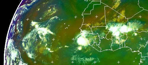
Winds are abatting a bit, maybe a window of opportunity as we're in the peak , (and should this area maintains its convection first) , afterwards Kyle is it you, déja vu?are you cooking something?
 . Time will tell but interresting wave exiting africa...
http://cimss.ssec.wisc.edu/tropic/real- ... 8split.jpg
Winds are abatting a bit, maybe a window of opportunity as we're in the peak , (and should this area maintains its convection first) , afterwards Kyle is it you, déja vu?are you cooking something?
0 likes
-
Gustywind
- Category 5
- Posts: 12334
- Joined: Mon Sep 03, 2007 7:29 am
- Location: Baie-Mahault, GUADELOUPE
000
AXNT20 KNHC 130601
TWDAT
TROPICAL WEATHER DISCUSSION
NWS TPC/NATIONAL HURRICANE CENTER MIAMI FL
205 AM EDT SAT SEP 13 2008
TROPICAL WEATHER DISCUSSION FOR NORTH AMERICA...CENTRAL
AMERICA...GULF OF MEXICO...CARIBBEAN SEA...NORTHERN SECTIONS
OF SOUTH AMERICA...AND ATLANTIC OCEAN TO THE AFRICAN COAST
FROM THE EQUATOR TO 32N. THE FOLLOWING INFORMATION IS BASED
ON SATELLITE IMAGERY...METEOROLOGICAL ANALYSIS...WEATHER
OBSERVATIONS...AND RADAR.
BASED ON 0000 UTC SURFACE ANALYSIS AND SATELLITE IMAGERY THROUGH
0345 UTC.
...TROPICAL WAVES...
TROPICAL WAVE IS ANALYZED ALONG 19W S OF 13N MOVING W NEAR 10
KT. LOW AMPLITUDE WAVE EMBEDDED WITHIN THE ITCZ WITH A SMALL
AREA OF DEEP LAYERED MOISTURE INDICATED BY MIMIC-TPW ANIMATION
AND NO ASSOCIATED SHOWERS/CONVECTION.
0 likes
-
bvigal

- S2K Supporter
- Posts: 2276
- Joined: Sun Jul 24, 2005 8:49 am
- Location: British Virgin Islands
- Contact:
Re: COA wave
canes04 wrote:Is Kyle ready to emerge off the coast?
Good eye!!! A new tropical wave. (I didn't notice it until yesterday.)
 Will it be Kyle? Right now, a low could form quickly almost anywhere, don't necessarily need a tropical wave. Will wait and see if this builds and holds some good convection before forming an opinion.
0 likes
-
Gustywind
- Category 5
- Posts: 12334
- Joined: Mon Sep 03, 2007 7:29 am
- Location: Baie-Mahault, GUADELOUPE
Re: COA wave
bvigal wrote:canes04 wrote:Is Kyle ready to emerge off the coast?
Good eye!!! A new tropical wave. (I didn't notice it until yesterday.)
Absolutely my bvigal
0 likes
-
Gustywind
- Category 5
- Posts: 12334
- Joined: Mon Sep 03, 2007 7:29 am
- Location: Baie-Mahault, GUADELOUPE
000
AXNT20 KNHC 131202
TWDAT
TROPICAL WEATHER DISCUSSION
NWS TPC/NATIONAL HURRICANE CENTER MIAMI FL
805 AM EDT SAT SEP 13 2008
TROPICAL WEATHER DISCUSSION FOR NORTH AMERICA...CENTRAL
AMERICA...GULF OF MEXICO...CARIBBEAN SEA...NORTHERN SECTIONS
OF SOUTH AMERICA...AND ATLANTIC OCEAN TO THE AFRICAN COAST
FROM THE EQUATOR TO 32N. THE FOLLOWING INFORMATION IS BASED
ON SATELLITE IMAGERY...METEOROLOGICAL ANALYSIS...WEATHER
OBSERVATIONS...AND RADAR.
BASED ON 0600 UTC SURFACE ANALYSIS AND SATELLITE IMAGERY THROUGH
1015 UTC.
...TROPICAL WAVES...
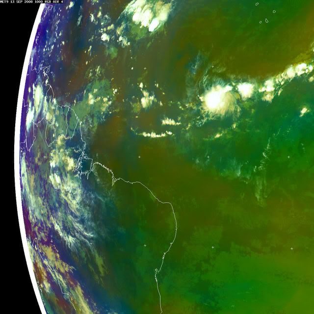
TROPICAL WAVE IS ANALYZED ALONG 20W S OF 13N MOVING W NEAR 10
KT. LOW AMPLITUDE WAVE EMBEDDED WITHIN THE ITCZ WITH A SMALL
AREA OF DEEP LAYERED MOISTURE INDICATED BY MIMIC-TPW ANIMATION.
ANY SHOWERS/CONVECTION ARE ASSOCIATED WITH THE ITCZ.
Here is our new guest ...
...
AXNT20 KNHC 131202
TWDAT
TROPICAL WEATHER DISCUSSION
NWS TPC/NATIONAL HURRICANE CENTER MIAMI FL
805 AM EDT SAT SEP 13 2008
TROPICAL WEATHER DISCUSSION FOR NORTH AMERICA...CENTRAL
AMERICA...GULF OF MEXICO...CARIBBEAN SEA...NORTHERN SECTIONS
OF SOUTH AMERICA...AND ATLANTIC OCEAN TO THE AFRICAN COAST
FROM THE EQUATOR TO 32N. THE FOLLOWING INFORMATION IS BASED
ON SATELLITE IMAGERY...METEOROLOGICAL ANALYSIS...WEATHER
OBSERVATIONS...AND RADAR.
BASED ON 0600 UTC SURFACE ANALYSIS AND SATELLITE IMAGERY THROUGH
1015 UTC.
...TROPICAL WAVES...
TROPICAL WAVE IS ANALYZED ALONG 20W S OF 13N MOVING W NEAR 10
KT. LOW AMPLITUDE WAVE EMBEDDED WITHIN THE ITCZ WITH A SMALL
AREA OF DEEP LAYERED MOISTURE INDICATED BY MIMIC-TPW ANIMATION.
ANY SHOWERS/CONVECTION ARE ASSOCIATED WITH THE ITCZ.
Here is our new guest
0 likes
Who is online
Users browsing this forum: No registered users and 80 guests