Storm2k 3:00PM EST Tropical Map

This is the general tropical discussion area. Anyone can take their shot at predicting a storms path.

Moderator: S2k Moderators

Forum rules

The posts in this forum are NOT official forecasts and should not be used as such. They are just the opinion of the poster and may or may not be backed by sound meteorological data. They are NOT endorsed by any professional institution or STORM2K. For official information, please refer to products from the National Hurricane Center and National Weather Service.

Help Support Storm2K
Message
Author
chadtm80

Storm2k 3:00PM EST Tropical Map

#1 Postby chadtm80 » Sat Jul 19, 2003 8:02 am

Image


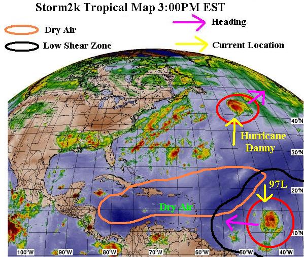
Hurricane Danny is still moving of to the NE at a good clip of 18mph.. He is expected to turn more due east later today or tommorow.. sustained winds are still estimated at 75MPH.. The big question is will he loop back around?? The even bigger question is will he survive enough through the cold waters to be able to regenerate after the loop???

97L is looking better this morning... It has split more from the ITZ and the convection seems to be forming over the low around 11.5n 41w.. She is moving w at 10- 15MPH... She has a definate chance at developement so interest along the Islands should be high


97L Track Map- http://www.wright-weather.com/data/wxp/ ... invest.gif

Danny Track Map- http://www.wunderground.com/tropical/tr ... model.html
Last edited by chadtm80 on Sat Jul 19, 2003 2:28 pm, edited 2 times in total.
0 likes   

User avatar
Scott_inVA
Storm2k Forecaster
Storm2k Forecaster
Posts: 1238
Joined: Sat Oct 12, 2002 5:44 pm
Location: Lexington, Virginia
Contact:

Invest 97 map

#2 Postby Scott_inVA » Sat Jul 19, 2003 8:09 am

I'm able to get a few of the globals to pick up Invest 97. ATTM, none of the models have I97 as a TC west of 65 degrees. But, they are interesting in that the track is exceptionally similar (even with the UKie which has been a wretched failure this year so far). TPC is not publishing tropicals on this, so I don't want to put it on our Model Map page. But, this is where we'll keep it until:
http://wrel.com/wx/modelmap2.jpg
If inclined, bookmark that addy until (?) something develops then I'll put it on the map page.

Also, anyone watching this enormous High in the North Atlantic? EC proggs 1031 on D6:
http://cyclone.plymouth.edu/cgi-bin/gen ... &cu=latest

Scott
0 likes   

chadtm80

#3 Postby chadtm80 » Sat Jul 19, 2003 8:19 am

There all showing now Scott.. :-)
0 likes   

User avatar
Scott_inVA
Storm2k Forecaster
Storm2k Forecaster
Posts: 1238
Joined: Sat Oct 12, 2002 5:44 pm
Location: Lexington, Virginia
Contact:

#4 Postby Scott_inVA » Sat Jul 19, 2003 8:21 am

chadtm80 wrote:There all showing now Scott.. :-)


Yep :x
Right after posting I checked and data was up. I've ingested and redone the map. Thanks.

Scott
0 likes   

chadtm80

#5 Postby chadtm80 » Sat Jul 19, 2003 8:24 am

Great!! Thanks as always! :-)
0 likes   

chadtm80

#6 Postby chadtm80 » Sat Jul 19, 2003 8:37 am

No eye evident on latest sat pic of danny.. Downgraded by this afternoon???

Image


Plus check out quickscat on 97L... Thoughts??? http://manati.wwb.noaa.gov/storm_at_ima ... _at_1.html
0 likes   

chadtm80

#7 Postby chadtm80 » Sat Jul 19, 2003 10:16 am

*97L future*


97L Will need to truck through all this dry air :darrow: out ahead of her... But other than that conditions are pretty good.... Any one know if we can expect the dry air to dissipate any??


Image


Here is the forecasted wind shear maps.. She sits in favorable conditions now, and with each passing day conditions shear wise improve out infront of her :darrow:

Image
0 likes   

User avatar
Stephanie
S2K Supporter
S2K Supporter
Posts: 23843
Age: 63
Joined: Thu Feb 06, 2003 9:53 am
Location: Glassboro, NJ

#8 Postby Stephanie » Sat Jul 19, 2003 10:23 am

Great maps & graphics guys! Keep them coming! :D
0 likes   

User avatar
Scott_inVA
Storm2k Forecaster
Storm2k Forecaster
Posts: 1238
Joined: Sat Oct 12, 2002 5:44 pm
Location: Lexington, Virginia
Contact:

#9 Postby Scott_inVA » Sat Jul 19, 2003 10:25 am

chadtm80 wrote:No eye evident on latest sat pic of danny.. Downgraded by this afternoon???


Plus check out quickscat on 97L... Thoughts??? http://manati.wwb.noaa.gov/storm_at_ima ... _at_1.html


Eye is present but cloud covered.

Also, orbit212 and manati sites appear down ATTM.

Scott
0 likes   

chadtm80

#10 Postby chadtm80 » Sat Jul 19, 2003 10:59 am

K scott.. Thanks!

Map above updated 11:15EST
0 likes   

User avatar
GulfBreezer
Category 5
Category 5
Posts: 2230
Joined: Wed Oct 09, 2002 8:58 pm
Location: Gulf Breeze Fl
Contact:

#11 Postby GulfBreezer » Sat Jul 19, 2003 11:21 am

Chad,
These maps are awesome and really help us to see what is being discussed! I, for one, really appreciate the graphics! It is like a learning experience that I just can't get on any other website! S2K ROCKS!!

Sandi
0 likes   

User avatar
southerngale
Retired Staff
Retired Staff
Posts: 27418
Joined: Thu Oct 10, 2002 1:27 am
Location: Southeast Texas (Beaumont area)

#12 Postby southerngale » Sat Jul 19, 2003 12:37 pm

I agree GB...Storm2k rocks!!

Thanks for the maps and graphics guys :D
0 likes   
Please support Storm2k by making a donation today. It is greatly appreciated! Click here: Image

Image my Cowboys Image my RocketsImage my Astros

chadtm80

#13 Postby chadtm80 » Sat Jul 19, 2003 2:33 pm

Map Updated at 3pm...

Convection deepening over what appears to be the "center" and


Anyone zoomed in on the vis loop??? I sees some spin?? anyone else?? or have I just been staring at these things to long that im see spins?? lol
0 likes   

User avatar
cycloneye
Admin
Admin
Posts: 145310
Age: 68
Joined: Thu Oct 10, 2002 10:54 am
Location: San Juan, Puerto Rico

#14 Postby cycloneye » Sat Jul 19, 2003 2:40 pm

Your are not alone looking at things spinning chad as I too see it spinning around 12.5n-44w.
0 likes   
Visit the Caribbean-Central America Weather Thread where you can find at first post web cams,radars
and observations from Caribbean basin members Click Here


Return to “Talkin' Tropics”

Who is online

Users browsing this forum: AtlanticWind, Hurricane2022, TampaWxLurker and 46 guests