This is my own, NON-OFFICIAL representation. Thought it was important to show it graphically for those who haven't seen the NRL plot, and may not read the discussion. THIS IS NOT A FORECAST.


Moderator: S2k Moderators


tolakram wrote:If that's true and the NHC does not expect landfall where the line depicts then they're in for a good deal of criticism. Can anyone confirm this? As a software engineer myself I would hope any map generating software they have would be able to change plot positions based on need.
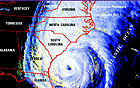

Recurve wrote:Graphic representation of the track based on the mention by the NHC that the straight track line could be misleading.
This is my own, NON-OFFICIAL representation. Thought it was important to show it graphically for those who haven't seen the NRL plot, and may not read the discussion. THIS IS NOT A FORECAST.
RL3AO wrote:tolakram wrote:If that's true and the NHC does not expect landfall where the line depicts then they're in for a good deal of criticism. Can anyone confirm this? As a software engineer myself I would hope any map generating software they have would be able to change plot positions based on need.
All they do is make the forecast points. The software just connects the dots and adds the cone based on 2/3 of the average forecast error.


Recurve wrote:Just a guess, that's how they do it. They use straight lines and draw the 2/3 average error as a perpendicular centered on the track. That gives the cone. Usually it works, and it's graphically logical and sound. I just used a Bezier curve.
Look at the NRL plot: http://www.nrlmry.navy.mil/TC.html
Select Hanna and click on the map to enlarge it.
webke wrote:Recurve wrote:Graphic representation of the track based on the mention by the NHC that the straight track line could be misleading.
This is my own, NON-OFFICIAL representation. Thought it was important to show it graphically for those who haven't seen the NRL plot, and may not read the discussion. THIS IS NOT A FORECAST.
Needlessto say because I am impacted by this. I know that previously it was asked for a pro-met to give a opinion on the track, I haven't seen a response to that and if there is a Met looking in what do you think the slight bend in the track would affect.
. 


Recurve wrote:Graphic representation of the track based on the mention by the NHC that the straight track line could be misleading.
This is my own, NON-OFFICIAL representation. Thought it was important to show it graphically for those who haven't seen the NRL plot, and may not read the discussion. THIS IS NOT A FORECAST.
Users browsing this forum: No registered users and 19 guests