
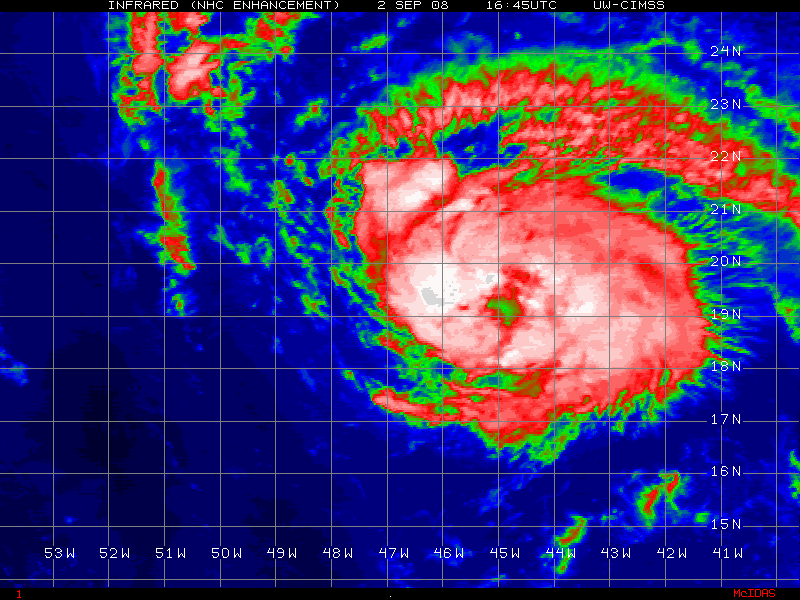
I'm a touch surprised they didn't raise the winds at all but there you go I suppose, I'd have gone higher then 55kts given the presentation and that clear as day eye.
Also note...its already 0.1N of the 12hr forecast point of the NHC and still got about 6hrs to go yet so could well be close to 20N by that point unless it bends back west.
ATL: IKE Discussion
Moderator: S2k Moderators
-
fasterdisaster
- Category 5

- Posts: 1868
- Joined: Mon Sep 19, 2005 4:41 pm
- Location: Miami, Florida
-
Matt-hurricanewatcher
Re:
KWT wrote:Well I think they are still using the data from Dvorak which was 3.5 and supported 55kts, though for what its worth it did show 3.5/4.5, not totally sure what that is about to be honest!
If I was using that I would of not went higher then 55-60 knots for Gustav for about 40% of its time over the gulf. No eye at all for a long time over the gulf...
I will stay with my 70 knots.
0 likes
-
superfly
Re: Re:
Matt-hurricanewatcher wrote:KWT wrote:Well I think they are still using the data from Dvorak which was 3.5 and supported 55kts, though for what its worth it did show 3.5/4.5, not totally sure what that is about to be honest!
If I was using that I would of not went higher then 55-60 knots for Gustav for about 40% of its time over the gulf. No eye at all for a long time over the gulf...
I will stay with my 70 knots.
Gustav never went below 4.5 on Dvorak in the GOM.
0 likes

-
Weatherfreak000
Gotta be kidding...THAT...is 55 Knots?
The structure clearly outlines a VERY, very well organized system...VERY much more organized then at the 5PM Advisory...but no wind increase? Insanity.
I'll eat my shoe if that storm isn't at least 60kts. I'll even pour some A1 on it when I do.
Edit: This storm is trending WAY more North then the NHC is seeing...I can't see this storm doing what the GFDL/GFS are saying. I'm gonna go out on a limb here and say that's not gonna happen.
Last edited by Weatherfreak000 on Tue Sep 02, 2008 8:25 pm, edited 1 time in total.
0 likes


-
wzrgirl1

- S2K Supporter

- Posts: 1360
- Joined: Sat Sep 04, 2004 6:44 am
- Location: Pembroke Pines, Florida
Re: ATL Tropical Storm IKE - Discussion
i think this will be an east coast storm....our only hope is that it isn't a very strong one
0 likes
Re:
gatorcane wrote:how is Ike going to plow through what looks to be a "trough" axis now created by that ULL shearing Hanna to bits?
Do you believe it will? Maybe that ULL will pick it up and send Ike fishing hopefully.
gator that is exactly what i said last nite
and i haven't given up the idea
in the hanna thread a pro-met earlier in the day hinted that the UL trough of NE coast was looking like it would hang on a little more than forecast, well
1. Ike is moving at a pretty brisk pace
2. that trough had better lift out "soon" or Ike will be turned 305 or so degrees NW (and this could also give him a at least brief period of southerly shear IMO) the longer the trough takes the higher latitude he will gain. I am not sure if a storm like Ike would slow as it makes the hypothetical turn more NW but at it's speed it could get up to 26 or more 28 or "so" should the trough be extra stubborn IMO .
3. at the very least i think the Ul trough may cause IKE to reach 62W at a higher latitude then he is progged and perhaps shift the highest chance for impact from the DR/ to the bahamas, OR allow him to feel the weakness created by hanna (assuming she makes it to SC latitude) possibly causing IKe to be a threat up the mid atlantic coast (as the ridge "should" be strong enough to keep him from recurving given a situation that i describe but the weakness could cause him to gain a bit of latitude again as he near the coast.
0 likes
-
tolakram
- Admin

- Posts: 20186
- Age: 62
- Joined: Sun Aug 27, 2006 8:23 pm
- Location: Florence, KY (name is Mark)
Re: ATL Tropical Storm IKE - Discussion
Ike on the move, will run into Hanna if he doesn't slow down. 

0 likes
-
crazycajuncane

- S2K Supporter
- Posts: 1097
- Joined: Sun Aug 15, 2004 2:51 pm
- Location: Lafayette, Louisiana
- Contact:
Re: ATL Tropical Storm IKE - Discussion
This is definitely a Texas Storm! Right?  Right?
  Hmmmm ?
West is the best. West all the way? I'd prefer Ike to
How crazy would this be to have to whole gulf coast heading back home for a few days and another mandatory evacuation take place? I know NO ONE wants to even think about this, but it's possible. So close between storms... we've got to believe Louisiana won't be impacted.
0 likes

Re: ATL Tropical Storm IKE - Discussion
Yep he is looking like a little speed demon on the IF2
http://www.ssd.noaa.gov/goes/flt/t4/loop-ir2.html
http://www.ssd.noaa.gov/goes/flt/t4/loop-ir2.html
0 likes
-
HurricaneRobert
- Category 3

- Posts: 812
- Joined: Fri May 18, 2007 9:31 pm
Re: ATL Tropical Storm IKE - Discussion
Are the rainbands disappearing? How strong does a storm have to be before it becomes annular? We know that it's not too uncommon in the Atlantic.
0 likes
Re: ATL Tropical Storm IKE - Discussion
What is it this year with tropical storms having eyes?
0 likes

Re: ATL Tropical Storm IKE - Discussion
HurricaneRobert wrote:Are the rainbands disappearing? How strong does a storm have to be before it becomes annular? We know that it's not too uncommon in the Atlantic.
If I remember correctly it's a windspeed >85kts, I don't know if it can be 85, but I know it is >85kts. To me this looks nothing annular at all though due to lack of eye and other characteristics.
Last edited by Hockey007 on Tue Sep 02, 2008 9:38 pm, edited 1 time in total.
0 likes
Who is online
Users browsing this forum: No registered users and 37 guests