ATL GUSTAV: Tropical Depression - Discussion

Moderator: S2k Moderators

Message
Author
User avatar
Stephanie
S2K Supporter
S2K Supporter
Posts: 23843
Age: 63
Joined: Thu Feb 06, 2003 9:53 am
Location: Glassboro, NJ

Re: Cat 2 Hurricane Gustav makes landfall-Cocodrie, LA

#10061 Postby Stephanie » Mon Sep 01, 2008 11:45 am

SoupBone wrote:Still trying to get info out of Houma and lower Terrebonne Parish. They are taking the brunt of this thing. Anyone seen or heard anything new? They are about the get the surge from the south so I'm getting a little anxious.


http://www.houmatoday.com/apps/pbcs.dll/frontpage

This is talking about damage and power being out. Houma is getting the brunt of the storm.
0 likes   

User avatar
stormy1970al
Tropical Storm
Tropical Storm
Posts: 158
Age: 55
Joined: Sat May 31, 2008 12:54 pm
Location: Fairhope AL

Re: Cat 2 Hurricane Gustav makes landfall-Cocodrie, LA

#10062 Postby stormy1970al » Mon Sep 01, 2008 11:47 am

Update from the Baldwin County Area in Alabama
Well we just had a nasty feeder band come through here. The winds are gusting pretty good here and it rained a good bit. There is a tornado warning in North Baldwin near hurricane and Bay Minette. I am off to work in a few minutes. I know I am nuts for going into work but they are open and we get paid time and half today. Hopefully the feeder bands will die down this afternoon.
0 likes   

User avatar
Enzo Aquarius
Tropical Storm
Tropical Storm
Posts: 160
Joined: Wed Jul 23, 2008 12:53 pm
Location: Canada

Re: Cat 2 Hurricane Gustav makes landfall-Cocodrie, LA

#10063 Postby Enzo Aquarius » Mon Sep 01, 2008 11:48 am

Stephanie wrote:
SoupBone wrote:Still trying to get info out of Houma and lower Terrebonne Parish. They are taking the brunt of this thing. Anyone seen or heard anything new? They are about the get the surge from the south so I'm getting a little anxious.


http://www.houmatoday.com/apps/pbcs.dll/frontpage

This is talking about damage and power being out. Houma is getting the brunt of the storm.


http://www.houmatoday.com/article/20080 ... ads_inland

Tons of reports of damage. Thanks for the site!
0 likes   

tolakram
Admin
Admin
Posts: 20009
Age: 62
Joined: Sun Aug 27, 2006 8:23 pm
Location: Florence, KY (name is Mark)

Re: Cat 2 Hurricane Gustav makes landfall-Cocodrie, LA

#10064 Postby tolakram » Mon Sep 01, 2008 11:49 am

Report on CNN indicated that while the waves were over topping the levees the water level is a couple of feet below the top. This was a CNN reporter reading a press release from the Army Core of Engineers. As far as I know nothing is confirmed.
0 likes   

User avatar
Enzo Aquarius
Tropical Storm
Tropical Storm
Posts: 160
Joined: Wed Jul 23, 2008 12:53 pm
Location: Canada

Re: Cat 2 Hurricane Gustav makes landfall-Cocodrie, LA

#10065 Postby Enzo Aquarius » Mon Sep 01, 2008 11:54 am

Part of the tornado warning in the Hattiesburg area has been cancelled, the warning area south of the city is still in effect.
0 likes   

Sanibel
Category 5
Category 5
Posts: 10375
Joined: Mon Aug 30, 2004 11:06 pm
Location: Offshore SW Florida

Re: Cat 2 Hurricane Gustav makes landfall-Cocodrie, LA

#10066 Postby Sanibel » Mon Sep 01, 2008 11:55 am

Let the pumps hold and let them have power.

Maybe they can get patches on the leaking levees.
0 likes   

User avatar
Chacor
Category 5
Category 5
Posts: 10229
Joined: Mon Oct 02, 2006 10:43 pm
Location: Singapore

#10067 Postby Chacor » Mon Sep 01, 2008 11:56 am

...CENTER OF GUSTAV APPROACHING MORGAN CITY LOUISIANA...

AT 1200 PM CDT...1700Z...THE CENTER OF HURRICANE GUSTAV WAS LOCATED
NEAR LATITUDE 29.6 NORTH...LONGITUDE 91.1 WEST OR ABOUT 10 MILES
SOUTHEAST OF MORGAN CITY LOUISIANA. THIS POSITION IS ALSO ABOUT
ABOUT 65 MILES...105 KM...SOUTHEAST OF LAFAYETTE LOUISIANA AND
ABOUT 65 MILES...105 KM...NEW ORLEANS OF LOUISIANA.

GUSTAV IS MOVING TOWARD THE NORTHWEST NEAR 15 MPH...24 KM/HR...AND
THIS GENERAL MOTION IS EXPECTED TO CONTINUE WITH A DECREASE IN THE
FORWARD SPEED DURING THE NEXT COUPLE OF DAYS. ON THE FORECAST
TRACK...THE CENTER OF GUSTAV WILL TRACK ALONG THE SOUTH CENTRAL
LOUISIANA COAST THIS AFTERNOON...THEN MOVE INTO WESTERN LOUISIANA
TONIGHT AND EASTERN TEXAS ON TUESDAY.

MAXIMUM SUSTAINED WINDS HAVE DECREASED TO NEAR 105 MPH...
170 KM/HR...WITH HIGHER GUSTS. GUSTAV IS A CATEGORY TWO HURRICANE
ON THE SAFFIR-SIMPSON SCALE. ADDITIONAL WEAKENING IS FORECAST AS
THE CENTER OF GUSTAV MOVES INLAND OVER LOUISIANA.
0 likes   

User avatar
Enzo Aquarius
Tropical Storm
Tropical Storm
Posts: 160
Joined: Wed Jul 23, 2008 12:53 pm
Location: Canada

Re: Cat 2 Hurricane Gustav makes landfall-Cocodrie, LA

#10068 Postby Enzo Aquarius » Mon Sep 01, 2008 11:59 am

The tornado warning in the Florida panhandle has been cancelled.
0 likes   

User avatar
SoupBone
Category 5
Category 5
Posts: 3111
Joined: Tue Sep 20, 2005 5:24 pm

Re: Cat 2 Hurricane Gustav makes landfall-Cocodrie, LA

#10069 Postby SoupBone » Mon Sep 01, 2008 12:01 pm

Getting some nasty gusts here in BR. On GRlvl3 it looks like we might be getting the eyewall pretty soon unless it turns west.
0 likes   

User avatar
Innotech
Category 5
Category 5
Posts: 1031
Joined: Mon Aug 30, 2004 5:32 pm
Location: Lafayette, Louisiana
Contact:

Re: Cat 2 Hurricane Gustav makes landfall-Cocodrie, LA

#10070 Postby Innotech » Mon Sep 01, 2008 12:06 pm

got a pretty good gust just now. Maybe 50-60 mph. Starting to get hairy.
0 likes   

User avatar
Enzo Aquarius
Tropical Storm
Tropical Storm
Posts: 160
Joined: Wed Jul 23, 2008 12:53 pm
Location: Canada

Re: Cat 2 Hurricane Gustav makes landfall-Cocodrie, LA

#10071 Postby Enzo Aquarius » Mon Sep 01, 2008 12:07 pm

Tornado warnings in Harrison County, Mississippi and southwest of Hattiesburg have been cancelled as well.

Correction, tornado warning in Harrison County has been reissued.

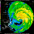
1202 PM CDT MON SEP 1 2008

THE NATIONAL WEATHER SERVICE IN NEW ORLEANS HAS ISSUED A

* TORNADO WARNING FOR...
HARRISON COUNTY IN SOUTHERN MISSISSIPPI...
THIS INCLUDES THE CITY OF BILOXI...
SOUTHWESTERN JACKSON COUNTY IN SOUTHERN MISSISSIPPI...
THIS INCLUDES THE CITIES OF...ST. MARTIN...OCEAN SPRINGS...

* UNTIL 100 PM CDT

* AT 1157 AM CDT...NATIONAL WEATHER SERVICE DOPPLER RADAR INDICATED A
TROPICAL BAND OF THUNDERSTORMS CAPABLE OF PRODUCING A TORNADO
EXTENDING FROM SAUCIER THROUGH OCEAN SPRINGS TO ABOUT 20 MILES
SOUTH OF PASCAGOULA...MOVING NORTHWEST AT 53 MPH.


and yet, ANOTHER tornado warning in Florida:

1205 PM CDT MON SEP 1 2008

THE NATIONAL WEATHER SERVICE IN MOBILE HAS ISSUED A

* TORNADO WARNING FOR...
SOUTHERN OKALOOSA COUNTY IN NORTHWEST FLORIDA...
THIS INCLUDES THE CITIES OF...FORT WALTON BEACH...DESTIN...

* UNTIL 1245 PM CDT

* AT 1202 PM CDT...THE NATIONAL WEATHER SERVICE INDICATED A SEVERE
THUNDERSTORM CAPABLE OF PRODUCING A TORNADO 9 MILES SOUTHEAST OF
DESTIN...MOVING NORTHWEST AT 41 MPH.

* THE TORNADO WILL BE NEAR...
DESTIN BY 1215 PM CDT...
EGLIN AFB BY 1220 PM CDT...


EDIT: And ANOTHER northwest of Hattiesburg:

1207 PM CDT MON SEP 1 2008

THE NATIONAL WEATHER SERVICE IN JACKSON HAS ISSUED A

* TORNADO WARNING FOR...
SOUTHERN SMITH COUNTY IN CENTRAL MISSISSIPPI...

* UNTIL 1245 PM CDT

* AT 1207 PM CDT...NATIONAL WEATHER SERVICE METEOROLOGISTS DETECTED A
SEVERE THUNDERSTORM CAPABLE OF PRODUCING A TORNADO 11 MILES EAST OF
TAYLORSVILLE...OR NEAR STRINGER...MOVING NORTHWEST AT 40 MPH.

* THE TORNADO WILL BE NEAR...
TAYLORSVILLE BY 1220 PM CDT...
6 MILES SOUTHWEST OF RALEIGH BY 1235 PM CDT...
0 likes   

soonertwister
Category 5
Category 5
Posts: 1091
Joined: Mon Jun 16, 2003 2:52 pm

#10072 Postby soonertwister » Mon Sep 01, 2008 12:14 pm

The COE has put in place concrete splash pans designed to prevent the scouring at the base of the levee walls outside the canal, and that works well with splashover.

But if the levee is overtopped by the water level, that's a whole different story. Waterfalling water coming over the levee will start to erode the soil at th edge of the splash pans, and the longer the situation is like that, the more erosion takes place. Once the splash pan has shifted, the levee wall is directly exposed, and will eventually fail.

A couple of hours ago they adjusted the surge level for NOLA from 10-12 to 10-14 feet. That's not much, but a foot or more of water pouring over a large portion of that levee is going to be pretty bad any way you slice it. 14 feet is definitely a lot more than a foot higher than the east levee on Industrial Canal in the Upper 9th Ward.
0 likes   

User avatar
jasons2k
Storm2k Executive
Storm2k Executive
Posts: 8245
Age: 51
Joined: Wed Jul 06, 2005 12:32 pm
Location: The Woodlands, TX

#10073 Postby jasons2k » Mon Sep 01, 2008 12:14 pm

Markedly more breezy here in Houston than it was this morning.

Been switching between CNN, FOX, and the local feed from WDSU. WDSU seems to be the most 'on the ball' by far, and all I can say about CNN is leave it to them to sensationalize it best they can - par for the course with them.

We're still not out of the woods yet by any means though, time will tell. The whole levee system is under a lot of stress right now.
0 likes   

User avatar
Enzo Aquarius
Tropical Storm
Tropical Storm
Posts: 160
Joined: Wed Jul 23, 2008 12:53 pm
Location: Canada

Re:

#10074 Postby Enzo Aquarius » Mon Sep 01, 2008 12:17 pm

jasons wrote:Been switching between CNN, FOX, and the local feed from WDSU. WDSU seems to be the most 'on the ball' by far, and all I can say about CNN is leave it to them to sensationalize it best they can - par for the course with them.


It's the only media outlet I have that gives me continuous Gustav coverage (other than this forum and NOAA of course :wink: ), so I guess I have to make due. :P

The tornado warning north of Hattiesburg has been cancelled, but a new one south of it has been issued:

1214 PM CDT MON SEP 1 2008

THE NATIONAL WEATHER SERVICE IN NEW ORLEANS HAS ISSUED A

* TORNADO WARNING FOR...
NORTHERN PEARL RIVER COUNTY IN SOUTHERN MISSISSIPPI...
THIS INCLUDES THE CITY OF POPLARVILLE...

* UNTIL 1245 PM CDT

* AT 1210 PM CDT...NATIONAL WEATHER SERVICE DOPPLER RADAR INDICATED A
SEVERE THUNDERSTORM CAPABLE OF PRODUCING A TORNADO 9 MILES EAST OF
POPLARVILLE...MOVING NORTHWEST AT 49 MPH.

* THE TORNADO WILL BE NEAR...
POPLARVILLE BY 1220 PM CDT..
0 likes   

User avatar
Tireman4
S2K Supporter
S2K Supporter
Posts: 5853
Age: 59
Joined: Fri Jun 30, 2006 1:08 pm
Location: Humble, Texas
Contact:

Re: Cat 2 Hurricane Gustav makes landfall-Cocodrie, LA

#10075 Postby Tireman4 » Mon Sep 01, 2008 12:18 pm

I agree Jason. We still need (Houston Area) to watch this. The winds in Humble have increased, but still partly cloudy.
0 likes   

User avatar
Innotech
Category 5
Category 5
Posts: 1031
Joined: Mon Aug 30, 2004 5:32 pm
Location: Lafayette, Louisiana
Contact:

Re: Cat 2 Hurricane Gustav makes landfall-Cocodrie, LA

#10076 Postby Innotech » Mon Sep 01, 2008 12:19 pm

the more I think about the levee design in New Orleans, the angrier I get. It is so half assed its not even funny. They need to consult with engineers from the Netherlands, who have the finest dike and levee systems in the world. It is highly important that these levees have thresholds far above even the strongest hurricane. It would cost a lot but so does search and rescue and extensive flood damage. Personally Id rarther spend a hundred million on getting the levees right than dealing with the social and political repercussions of a disasterl ike Katrina. but then again, Im not a Louisiana politician.
0 likes   

User avatar
jasons2k
Storm2k Executive
Storm2k Executive
Posts: 8245
Age: 51
Joined: Wed Jul 06, 2005 12:32 pm
Location: The Woodlands, TX

Re: Re:

#10077 Postby jasons2k » Mon Sep 01, 2008 12:19 pm

Enzo Aquarius wrote:
jasons wrote:Been switching between CNN, FOX, and the local feed from WDSU. WDSU seems to be the most 'on the ball' by far, and all I can say about CNN is leave it to them to sensationalize it best they can - par for the course with them.


It's the only media outlet I have that gives me continuous Gustav coverage (other than this forum and NOAA of course :wink: ), so I guess I have to make due. :P


You can stream here: http://www.wdsu.com/index.html

But the feed on DirecTV is pretty darn cool.
0 likes   

User avatar
Enzo Aquarius
Tropical Storm
Tropical Storm
Posts: 160
Joined: Wed Jul 23, 2008 12:53 pm
Location: Canada

Re: Cat 2 Hurricane Gustav makes landfall-Cocodrie, LA

#10078 Postby Enzo Aquarius » Mon Sep 01, 2008 12:19 pm

A tornado 5 miles south of Baton Rouge has been reported by CNN, yet there's no tornado warning for it?

Also, thanks for the stream!
0 likes   

User avatar
Windy
S2K Supporter
S2K Supporter
Posts: 1628
Joined: Mon Sep 13, 2004 10:13 pm

Re: Cat 2 Hurricane Gustav makes landfall-Cocodrie, LA

#10079 Postby Windy » Mon Sep 01, 2008 12:25 pm

Innotech wrote:the more I think about the levee design in New Orleans, the angrier I get. It is so half assed its not even funny. They need to consult with engineers from the Netherlands, who have the finest dike and levee systems in the world. It is highly important that these levees have thresholds far above even the strongest hurricane. It would cost a lot but so does search and rescue and extensive flood damage. Personally Id rarther spend a hundred million on getting the levees right than dealing with the social and political repercussions of a disasterl ike Katrina. but then again, Im not a Louisiana politician.


Oh, it's way more expensive than that -- it'd be billions up on billions. But I agree; if you're going to have a major metropolitan city below sea level that is very prone to getting hurricanes, you should fortify it so you don't have to drain the place every 20 years. It's not like we live in Haiti and can't afford it that kind of protection.
0 likes   

User avatar
Enzo Aquarius
Tropical Storm
Tropical Storm
Posts: 160
Joined: Wed Jul 23, 2008 12:53 pm
Location: Canada

Re: Cat 2 Hurricane Gustav makes landfall-Cocodrie, LA

#10080 Postby Enzo Aquarius » Mon Sep 01, 2008 12:26 pm

1706 5 SE BATON ROUGE EAST BATON ROUGE LA 3040 9107 POSSIBLE TORNADO SNAPPED 4 LARGE TREES NEAR BLUE BAYOU WATER PARK. (LIX)


1221 PM CDT MON SEP 1 2008

THE NATIONAL WEATHER SERVICE IN MOBILE HAS ISSUED A

* TORNADO WARNING FOR...
CENTRAL BALDWIN COUNTY IN SOUTHWEST ALABAMA...
THIS INCLUDES THE CITY OF BAY MINETTE...

* UNTIL 1245 PM CDT

* AT 1216 PM CDT...THE NATIONAL WEATHER SERVICE INDICATED A SEVERE
THUNDERSTORM CAPABLE OF PRODUCING A TORNADO NEAR ROSINTON...OR
ABOUT 19 MILES SOUTH OF BAY MINETTE...MOVING NORTHWEST AT 42 MPH.

* THE TORNADO WILL BE NEAR...
STEELWOOD AND STAPLETON BY 1230 PM CDT...
CROSSROADS BY 1240 PM CDT...
HURRICANE BY 1245 PM CDT...
Last edited by Enzo Aquarius on Mon Sep 01, 2008 12:26 pm, edited 1 time in total.
0 likes   


Return to “2008”

Who is online

Users browsing this forum: No registered users and 5 guests