ATL GUSTAV: Tropical Depression - Discussion

Moderator: S2k Moderators

Message
Author
jlauderdal
S2K Supporter
S2K Supporter
Posts: 7183
Joined: Wed May 19, 2004 5:46 am
Location: NE Fort Lauderdale
Contact:

Re: Re:

#781 Postby jlauderdal » Sun Aug 24, 2008 9:02 am

Aquawind wrote:
Gustywind wrote:24/1145 UTC 12.0N 64.8W T1.0/1.0 94L -- Atlantic Ocean
http://www.ssd.noaa.gov/PS/TROP/positions.html


Wow whimpy T Numbers yet. Impressive looking visible this morning for those numbers imo.


remember fay around PR, looked like a 1 at least and was an invest
0 likes   

User avatar
Emmett_Brown
Category 5
Category 5
Posts: 1432
Joined: Wed Aug 24, 2005 9:10 pm
Location: Sarasota FL

Re: ATL: Invest 94L in Eastern Caribbean Sea

#782 Postby Emmett_Brown » Sun Aug 24, 2008 9:03 am

Sanibel wrote:Reconvected near the center last night in D-Max.

Center not obvious -which means it is closer to the convection and therefore stronger. Somewhere near 13N-64W

Obvious player here. Should get a good hurricane from this one.

Fast forward movement shows new conditions are in Caribbean.

GOM?


I am thinking the same thing Sanibel... has that look. Regarding the fast movement currently being observed, I think the models that are showing an immediate NW turn into Hispaniola are underestimating the ridge to the N. At this rate, I would think E Cuba would be more likely. This looks to me like another land lover... SW Bahamas/Straits seems possible IMO.
0 likes   

rockyman
Category 5
Category 5
Posts: 1967
Joined: Thu Jun 26, 2003 12:24 pm
Location: Dauphin Island, AL

#783 Postby rockyman » Sun Aug 24, 2008 9:07 am

has recon been canceled for today?
0 likes   

User avatar
deltadog03
Professional-Met
Professional-Met
Posts: 3580
Joined: Tue Jul 05, 2005 6:16 pm
Location: Macon, GA

Re: ATL: Invest 94L in Eastern Caribbean Sea

#784 Postby deltadog03 » Sun Aug 24, 2008 9:07 am

Something is spinning for sure.
0 likes   

User avatar
cheezyWXguy
Category 5
Category 5
Posts: 6108
Joined: Mon Feb 13, 2006 12:29 am
Location: Dallas, TX

Re: Re:

#785 Postby cheezyWXguy » Sun Aug 24, 2008 9:09 am

jlauderdal wrote:
Aquawind wrote:
Gustywind wrote:24/1145 UTC 12.0N 64.8W T1.0/1.0 94L -- Atlantic Ocean
http://www.ssd.noaa.gov/PS/TROP/positions.html


Wow whimpy T Numbers yet. Impressive looking visible this morning for those numbers imo.


remember fay around PR, looked like a 1 at least and was an invest

Yes but that is because it didnt have a surface circulation, but this one does. Note that T-numbers were pretty wimpy on that one at the time as well. Only about a 1.5 or 2, despite the having the mlc of a strong tropical storm.
0 likes   

User avatar
alan1961
Category 2
Category 2
Posts: 771
Joined: Mon Mar 20, 2006 11:58 am
Location: Derby, Derbyshire, England
Contact:

Re: ATL: Invest 94L in Eastern Caribbean Sea

#786 Postby alan1961 » Sun Aug 24, 2008 9:11 am

yes looks like rotation on this one and its dragging in some convection on its southern side.
0 likes   

meteorologyman
Category 2
Category 2
Posts: 541
Joined: Wed Mar 15, 2006 6:48 pm
Location: Florida, Kissimmee/St.CLoud

Re: ATL: Invest 94L in Eastern Caribbean Sea

#787 Postby meteorologyman » Sun Aug 24, 2008 9:25 am

I'm curious if the sun has any involvement in intensifying tropical cyclones, I don't mean by providing heat for the sea or increasing humidity but more in providing energy.

I'm looking at the motion satellite picture and I seen the refelection of the sun but dissapears after 1 or 2 frames but it's about to head over 94 L in 2 hours
Last edited by meteorologyman on Sun Aug 24, 2008 9:27 am, edited 1 time in total.
0 likes   

User avatar
cycloneye
Admin
Admin
Posts: 145350
Age: 68
Joined: Thu Oct 10, 2002 10:54 am
Location: San Juan, Puerto Rico

Re:

#788 Postby cycloneye » Sun Aug 24, 2008 9:26 am

rockyman wrote:has recon been canceled for today?


No recon today.The plan of the day for Monday is not out yet.
0 likes   

jlauderdal
S2K Supporter
S2K Supporter
Posts: 7183
Joined: Wed May 19, 2004 5:46 am
Location: NE Fort Lauderdale
Contact:

Re: Re:

#789 Postby jlauderdal » Sun Aug 24, 2008 9:34 am

remember fay around PR, looked like a 1 at least and was an invest[/quote]
Yes but that is because it didnt have a surface circulation, but this one does. Note that T-numbers were pretty wimpy on that one at the time as well. Only about a 1.5 or 2, despite the having the mlc of a strong tropical storm.[/quote]
where is the center of the surface circulation and what is your source?
0 likes   

User avatar
StormTracker
S2K Supporter
S2K Supporter
Posts: 2903
Age: 59
Joined: Thu Jun 29, 2006 6:06 am
Location: Quail Heights(Redlands), FL.

Re: ATL: Invest 94L in Eastern Caribbean Sea

#790 Postby StormTracker » Sun Aug 24, 2008 9:36 am

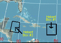
Anyone think the Herbert Box theory may come into play with this one?

Image

Hebert says that a Hurricane does not have to pass through these boxes to hit, but if they do "you better pay attention". The 1935 Labor day Hurricane that devastated the Florida Keys developed west of this box and Hurricane Andrew passed NE of this box, so there are exceptions to the rule.
0 likes   

User avatar
cycloneye
Admin
Admin
Posts: 145350
Age: 68
Joined: Thu Oct 10, 2002 10:54 am
Location: San Juan, Puerto Rico

Re: ATL: Invest 94L in Eastern Caribbean Sea

#791 Postby cycloneye » Sun Aug 24, 2008 9:41 am

I think this was not posted earlier this morning so here it is:

Image
0 likes   

User avatar
GeneratorPower
S2K Supporter
S2K Supporter
Posts: 1648
Age: 45
Joined: Sun Dec 18, 2005 11:48 pm
Location: Huntsville, AL

#792 Postby GeneratorPower » Sun Aug 24, 2008 10:12 am

Good grief looking at the amount of turning on IR this morning I would have thought a lot more people would be posting/interested in this thing. Looks fantastic to me, and you usually can't tell much from IR.

http://www.ssd.noaa.gov/goes/east/tatl/loop-avn.html
0 likes   

User avatar
cycloneye
Admin
Admin
Posts: 145350
Age: 68
Joined: Thu Oct 10, 2002 10:54 am
Location: San Juan, Puerto Rico

Re: ATL: Invest 94L in Eastern Caribbean Sea

#793 Postby cycloneye » Sun Aug 24, 2008 10:17 am

NHC plans recon missions starting on Monday afternoon (If Necessary)

Code: Select all

NOUS42 KNHC 241515
WEATHER RECONNAISSANCE FLIGHTS
CARCAH, NATIONAL HURRICANE CENTER, MIAMI, FL.
1100 AM EDT SUN 24 AUGUST 2008
SUBJECT: TROPICAL CYCLONE PLAN OF THE DAY (TCPOD)
         VALID 25/1100Z TO 26/1100Z AUGUST 2008
         TCPOD NUMBER.....08-085

I. ATLANTIC REQUIREMENTS
   1. CARIBBEAN SUSPECT AREA
      FLIGHT ONE - TEAL 70
      A. 25/1800Z
      B. AFXXX 01EEA INVEST
      C. 25/1430Z
      D. 15.5N 70.0W
      E. 25/1700Z TO 25/2200Z
      F. SFC TO 10,000 FT

      FLIGHT TWO ? TEAL 71
      A. 26/0600Z
      B. AFXXX 0207A CYCLONE
      C. 26/0300Z
      D. 16.5N 72.0W
      E. 26/0500Z TO 26/1200Z
      F. SFC TO 10,000 FT

   2. SUCCEEDING DAY OUTLOOK: CONTINUE 6-HRLY FIXES
      IF SYSTEM DEVELOPS.

http://www.nhc.noaa.gov/text/MIAREPRPD.shtml?
0 likes   

User avatar
gatorcane
S2K Supporter
S2K Supporter
Posts: 23691
Age: 47
Joined: Sun Mar 13, 2005 3:54 pm
Location: Boca Raton, FL

#794 Postby gatorcane » Sun Aug 24, 2008 10:20 am

I had a feeling 94L was a go when I saw it a couple of days ago and took a look at the synoptics setup (look back a couple of days ago at my posts on this system). Code red by NHC is imminent probably within the next couple of advisories.

I haven't had alot of time to analyze current and future synoptics so have been checking in from time-to-time on this one and browsing member posts for updates -- will probably get some more time in about 24 hours.
0 likes   

Clipper96

Re: ATL: Invest 94L in Eastern Caribbean Sea

#795 Postby Clipper96 » Sun Aug 24, 2008 10:25 am

StormTracker wrote:Anyone think the Herbert Box theory may come into play with this one?

Image

Hebert says that a Hurricane does not have to pass through these boxes to hit, but if they do "you better pay attention". The 1935 Labor day Hurricane that devastated the Florida Keys developed west of this box and Hurricane Andrew passed NE of this box, so there are exceptions to the rule.
So are Katrina, Rita, Allen, Isabel, Frederick....it's not much of a rule when there are so many cat4/5 "violators".
0 likes   

cpdaman
Category 5
Category 5
Posts: 3131
Joined: Sat Jun 10, 2006 11:44 am
Location: SPB county (gulf stream)

Re: ATL: Invest 94L in Eastern Caribbean Sea

#796 Postby cpdaman » Sun Aug 24, 2008 10:29 am

Clipper96 wrote:
StormTracker wrote:Anyone think the Herbert Box theory may come into play with this one?

Image

Hebert says that a Hurricane does not have to pass through these boxes to hit, but if they do "you better pay attention". The 1935 Labor day Hurricane that devastated the Florida Keys developed west of this box and Hurricane Andrew passed NE of this box, so there are exceptions to the rule.
So are Katrina, Rita, Allen, Isabel, Frederick....it's not much of a rule when there are so many cat4/5 "violators".


also what's the deal w/ herbert box 2, i would guess these would effect florida a higher % of the time in october (but probably still lower than 50%)
0 likes   

Clipper96

#797 Postby Clipper96 » Sun Aug 24, 2008 10:30 am

Speaking of broken rules, 94 appears ready to put the nail in the coffin of the "Hope Rule" proscribing eastern Caribbean storms.
0 likes   

cpdaman
Category 5
Category 5
Posts: 3131
Joined: Sat Jun 10, 2006 11:44 am
Location: SPB county (gulf stream)

Re: ATL: Invest 94L in Eastern Caribbean Sea

#798 Postby cpdaman » Sun Aug 24, 2008 10:32 am

Clipper96 wrote:
StormTracker wrote:Anyone think the Herbert Box theory may come into play with this one?

Image

Hebert says that a Hurricane does not have to pass through these boxes to hit, but if they do "you better pay attention". The 1935 Labor day Hurricane that devastated the Florida Keys developed west of this box and Hurricane Andrew passed NE of this box, so there are exceptions to the rule.
So are Katrina, Rita, Allen, Isabel, Frederick....it's not much of a rule when there are so many cat4/5 "violators".


also what's the deal w/ herbert box 2, i would guess these would effect florida a higher % of the time in october (but probably still lower than 50%), but i think the herbert box 1 has some amount of validity concerning "if it misses" the box, S.FL has usually a low chance of a direct hit
0 likes   

User avatar
cycloneye
Admin
Admin
Posts: 145350
Age: 68
Joined: Thu Oct 10, 2002 10:54 am
Location: San Juan, Puerto Rico

Re: ATL: Invest 94L in Eastern Caribbean Sea=Recon on Monday

#799 Postby cycloneye » Sun Aug 24, 2008 10:33 am

The latest visible pic.You can also see on the top 95L.

Image
0 likes   

Clipper96

#800 Postby Clipper96 » Sun Aug 24, 2008 10:37 am

Uh-oh...

94 has both northeast and southwest outflow channels.

...you're all in trouble now.
0 likes   


Return to “2008”

Who is online

Users browsing this forum: No registered users and 4 guests