ATL: Tropical Depression Fay

Moderator: S2k Moderators

Message
Author
jhamps10

Re: ATL: Invest 92L - Central Atlantic

#701 Postby jhamps10 » Mon Aug 11, 2008 5:03 pm

wxman57 wrote:Oh, I plotted a 12Z Friday streamline forecast of 700-400mb winds (10,000-20,000ft). I identified the projected location of 92L on there. Pink lines are streamlines. Yellow lines are a 1MB surface pressure field forecast. As you can see, it may have a hard time getting to Florida with westerly winds across the state behind that upper trof. The only two choices appear to be recurve (if it develops) or head west to Mexico (if it doesn't develop).

Image


umm you might realize that you are in a total minority there, this won't recurve or if it does then it would be the biggest shock of the week. and it would destroy every single model for it's track. no way it recurves into a huge high up north which has been posted several times on here, so there is little need to bring it up again.
0 likes   

User avatar
KWT
Category 5
Category 5
Posts: 31415
Joined: Tue Aug 17, 2004 11:02 am
Location: UK!!!

#702 Postby KWT » Mon Aug 11, 2008 5:03 pm

wxman57, not a single model has this recruving and equally none have it into Mexico...hard to ignore every single model pretty much having exactly the same general path towards the Bahamas/Caribbean Islands.

however I do agree I think the LLC is not with us any more, either that or its tucked under the convection and we just can't see it anymore.... :double:
Last edited by KWT on Mon Aug 11, 2008 5:05 pm, edited 1 time in total.
0 likes   

Scorpion

#703 Postby Scorpion » Mon Aug 11, 2008 5:04 pm

Well there's some pretty cold cloud tops developing over 92L, so thats a good sign of development.
0 likes   

MiamiensisWx

Re: ATL: Invest 92L - Central Atlantic

#704 Postby MiamiensisWx » Mon Aug 11, 2008 5:04 pm

wxman57 wrote:Oh, I plotted a 12Z Friday streamline forecast of 700-400mb winds (10,000-20,000ft). I identified the projected location of 92L on there. Pink lines are streamlines. Yellow lines are a 1MB surface pressure field forecast. As you can see, it may have a hard time getting to Florida with westerly winds across the state behind that upper trof. The only two choices appear to be recurve (if it develops) or head west to Mexico (if it doesn't develop).

Image

The Chinese invasion in southern Mississippi is disconcerting...

I apologize for the brief OT tangent, but I noticed that apparition on the grid.
Last edited by MiamiensisWx on Mon Aug 11, 2008 5:07 pm, edited 1 time in total.
0 likes   

User avatar
HURAKAN
Professional-Met
Professional-Met
Posts: 46086
Age: 38
Joined: Thu May 20, 2004 4:34 pm
Location: Key West, FL
Contact:

#705 Postby HURAKAN » Mon Aug 11, 2008 5:04 pm

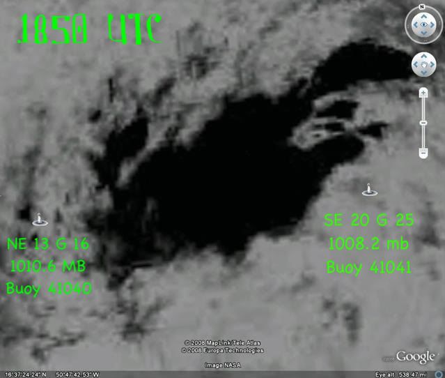
Image

Very low pressure being reported by buoy 41041
0 likes   

User avatar
cycloneye
Admin
Admin
Posts: 145337
Age: 68
Joined: Thu Oct 10, 2002 10:54 am
Location: San Juan, Puerto Rico

Re: ATL: Invest 92L - Central Atlantic

#706 Postby cycloneye » Mon Aug 11, 2008 5:05 pm

We need a quickscat or Recon to confirm a llc or not:I know that recon is slated for tuesday afternoon,but maybe a Q pass tonight can resolve the debate,of course if the pass gets the center and not misses.
0 likes   

User avatar
x-y-no
Category 5
Category 5
Posts: 8359
Age: 65
Joined: Wed Aug 11, 2004 12:14 pm
Location: Fort Lauderdale, FL

Re: ATL: Invest 92L - Central Atlantic

#707 Postby x-y-no » Mon Aug 11, 2008 5:06 pm

wxman57 wrote: As you can see, it may have a hard time getting to Florida with westerly winds across the state behind that upper trof. The only two choices appear to be recurve (if it develops) or head west to Mexico (if it doesn't develop).


It's all in te timing ... it could avoid the recurve if it's slow enough (the 12Z GFS moves an open wave quite slowly past PR and Hispaniola). 'm not invested in any particular solution - just raising a third possibility.
0 likes   

User avatar
KWT
Category 5
Category 5
Posts: 31415
Joined: Tue Aug 17, 2004 11:02 am
Location: UK!!!

#708 Postby KWT » Mon Aug 11, 2008 5:08 pm

The other thing that should be noted about wxman57 chart is it does suggest there would be a more northerly movement...but the models after that time period strongly build the high back westwards, esp at higher levels...

would there be anyway of putting up a chart for say next Sunday like that?
0 likes   

User avatar
wxman57
Moderator-Pro Met
Moderator-Pro Met
Posts: 22979
Age: 67
Joined: Sat Jun 21, 2003 8:06 pm
Location: Houston, TX (southwest)

Re: ATL: Invest 92L - Central Atlantic

#709 Postby wxman57 » Mon Aug 11, 2008 5:08 pm

x-y-no wrote:I'm hesitant to disagree with you, but in this case I think I do somewhat. Yeas, it doesn't have as well defined a surface circulation as it did yesterday afternoon, but It does appears to still have a closed circulation. And the big difference is that today it has convection over that center which has been gradually improving all day long, whilst yesterday it had significantly displaced convection that declined as the day went on.

Of course that has to persist overnight, but I'd say the probability of that is fairly good.


To me, it appears the "center" is a broad elliptical area perhaps 200-250 miles across today and oriented NE-SW. The convection appears to be forming on the NW side of this broad circulation. Now it's possible that if the convection persists that a tight LLC could form beneath it, and we could have development. Persistence of the convection is the key. Is the mechanism that's causing the present convective burst going to be present tomorrow?
0 likes   

User avatar
wxman57
Moderator-Pro Met
Moderator-Pro Met
Posts: 22979
Age: 67
Joined: Sat Jun 21, 2003 8:06 pm
Location: Houston, TX (southwest)

Re: ATL: Invest 92L - Central Atlantic

#710 Postby wxman57 » Mon Aug 11, 2008 5:10 pm

MiamiensisWx wrote:http://myweb.cableone.net/nolasue/92Lb.gif
The Chinese invasion in southern Mississippi is disconcerting...

I apologize for the brief OT tangent, but I noticed that apparition on the grid.


What you see there is Mississippi Power's service area plotted on the map background.

Ok, enough looking at the tropics for tonight. Time for dinner & Olympics.
0 likes   

User avatar
Aquawind
Category 5
Category 5
Posts: 6714
Age: 62
Joined: Mon Jun 16, 2003 10:41 pm
Location: Salisbury, NC
Contact:

Re: ATL: Invest 92L - Central Atlantic

#711 Postby Aquawind » Mon Aug 11, 2008 5:10 pm

The Chinese invasion in southern Mississippi is disconcerting...


:lol: :lol:

Tomorrow morning's visable should be intersting if the convection is still going.
0 likes   

Honeyko

#712 Postby Honeyko » Mon Aug 11, 2008 5:11 pm

Prediction: Great Red Spot on IR over LLC by midnight. Declared TD by 2am or 5am; declared TS by 11am.

Personal Forecast Disclaimer:
The posts in this forum are NOT official forecast and should not be used as such. They are just the opinion of the poster and may or may not be backed by sound meteorological data. They are NOT endorsed by any professional institution or storm2k.org. For official information, please refer to the NHC and NWS products.
0 likes   

RL3AO
Moderator-Pro Met
Moderator-Pro Met
Posts: 16308
Joined: Thu Jun 14, 2007 10:03 pm
Location: NC

Re:

#713 Postby RL3AO » Mon Aug 11, 2008 5:17 pm

Honeyko wrote:Prediction: Great Red Spot on IR over LLC by midnight. Declared TD by 2am or 5am; declared TS by 11am.

Personal Forecast Disclaimer:
The posts in this forum are NOT official forecast and should not be used as such. They are just the opinion of the poster and may or may not be backed by sound meteorological data. They are NOT endorsed by any professional institution or storm2k.org. For official information, please refer to the NHC and NWS products.


I haven't been following this much today, but didn't you call this dead last night?
0 likes   

User avatar
Aquawind
Category 5
Category 5
Posts: 6714
Age: 62
Joined: Mon Jun 16, 2003 10:41 pm
Location: Salisbury, NC
Contact:

#714 Postby Aquawind » Mon Aug 11, 2008 5:19 pm

I just don't see enough data or visual evidence at this point to support any LLC until we get persitant convection and visable at least. Recon at best. Same ole story looking for persitance as mentioned.
0 likes   

User avatar
cycloneye
Admin
Admin
Posts: 145337
Age: 68
Joined: Thu Oct 10, 2002 10:54 am
Location: San Juan, Puerto Rico

Re: ATL: Invest 92L - Central Atlantic

#715 Postby cycloneye » Mon Aug 11, 2008 5:21 pm

More symetrical:

Image
0 likes   

User avatar
HURAKAN
Professional-Met
Professional-Met
Posts: 46086
Age: 38
Joined: Thu May 20, 2004 4:34 pm
Location: Key West, FL
Contact:

Re: ATL: Invest 92L - Central Atlantic

#716 Postby HURAKAN » Mon Aug 11, 2008 5:21 pm

081008 2145:

Image

081108 2145:

Image
0 likes   

User avatar
KWT
Category 5
Category 5
Posts: 31415
Joined: Tue Aug 17, 2004 11:02 am
Location: UK!!!

#717 Postby KWT » Mon Aug 11, 2008 5:23 pm

Clearly it looks better then it did yesterday Hurakan from a convective standpoint though I do agree I'm having a real hard time finding any LLC.
0 likes   

Stratosphere747
Category 5
Category 5
Posts: 3772
Joined: Thu Sep 11, 2003 8:34 pm
Location: Surfside Beach/Freeport Tx
Contact:

Re: ATL: Invest 92L - Central Atlantic

#718 Postby Stratosphere747 » Mon Aug 11, 2008 5:23 pm

The problem is the images that are continually posted don't specifically show a huge amount of improvement.

It's the reverse of yesterday.

Convection vs. Circulation.
0 likes   

User avatar
HURAKAN
Professional-Met
Professional-Met
Posts: 46086
Age: 38
Joined: Thu May 20, 2004 4:34 pm
Location: Key West, FL
Contact:

#719 Postby HURAKAN » Mon Aug 11, 2008 5:26 pm

It's always the same question. Does it have a well-defined LLC? Only QuickSCAT and RECON can confirm that if it's present under the convection.
0 likes   

User avatar
cycloneye
Admin
Admin
Posts: 145337
Age: 68
Joined: Thu Oct 10, 2002 10:54 am
Location: San Juan, Puerto Rico

Re: ATL: Invest 92L - Central Atlantic

#720 Postby cycloneye » Mon Aug 11, 2008 5:28 pm

Image
0 likes   


Return to “2008”

Who is online

Users browsing this forum: Google Adsense [Bot] and 6 guests