ATL: Tropical Depression Fay

Moderator: S2k Moderators

Message
Author
Honeyko

Re: ATL: Invest 92L - Central Atlantic

#621 Postby Honeyko » Mon Aug 11, 2008 3:32 pm

Honeyko wrote:It was this >< close to being snuffed last evening, but the subsidence relaxed just enough to enable 92 to keep sputtering through the overnight and morning. As the SE trough (and ULL and sw-shear) slacken, 92 should go ahead and develop.
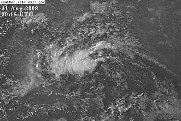
In fact, judging from near-sunset visibles, I'll go out on a limb and say 92 will develop quickly now. It has a really good look to it: Blob with a big rat-tail.

In a subsiding environment, a storm either dies, or it intensifies quickly (after establishing a stronger anticyclone aloft) due to a more favorable pressure gradient than normal. With 92L, we get to watch both.
Last edited by Honeyko on Mon Aug 11, 2008 3:34 pm, edited 2 times in total.
0 likes   

User avatar
boca
Category 5
Category 5
Posts: 6367
Age: 60
Joined: Mon Dec 15, 2003 8:49 am
Location: Boca Raton,FL

Re: ATL: Invest 92L - Central Atlantic

#622 Postby boca » Mon Aug 11, 2008 3:32 pm

I smell a recurve with 92L, I'm not convinced it will even affect the NE Leeward Islands. Its already moving NW and unless the bermuda high builds in it won't turn back west.
0 likes   

User avatar
HURAKAN
Professional-Met
Professional-Met
Posts: 46086
Age: 38
Joined: Thu May 20, 2004 4:34 pm
Location: Key West, FL
Contact:

Re: ATL: Invest 92L - Central Atlantic

#623 Postby HURAKAN » Mon Aug 11, 2008 3:33 pm

boca wrote:I smell a recurve with 92L, I'm not convinced it will even affect the NE Leeward Islands. Its already moving NW and unless the bermuda high builds in it won't turn back west.


That's what the computer models are thinking.
0 likes   

User avatar
deltadog03
Professional-Met
Professional-Met
Posts: 3580
Joined: Tue Jul 05, 2005 6:16 pm
Location: Macon, GA

Re: ATL: Invest 92L - Central Atlantic

#624 Postby deltadog03 » Mon Aug 11, 2008 3:34 pm

:uarrow: Boca, it is suppose to build back..That forecasted from all the models anyway.
0 likes   

User avatar
Weatherboy1
Category 5
Category 5
Posts: 1189
Age: 49
Joined: Mon Jul 05, 2004 1:50 pm
Location: Jupiter/Sarasota, FL

#625 Postby Weatherboy1 » Mon Aug 11, 2008 3:36 pm

looks to me this thing is trying to get its act together with a center possibly consolidating in the 14N 48W area. Now that the possible center appears to be pulling together under or near the main area of convection, I wouldn't be surprised to see this thing start to pop.
0 likes   

User avatar
gatorcane
S2K Supporter
S2K Supporter
Posts: 23691
Age: 47
Joined: Sun Mar 13, 2005 3:54 pm
Location: Boca Raton, FL

#626 Postby gatorcane » Mon Aug 11, 2008 3:36 pm

I think he meant 93L
Last edited by gatorcane on Mon Aug 11, 2008 3:36 pm, edited 2 times in total.
0 likes   

User avatar
deltadog03
Professional-Met
Professional-Met
Posts: 3580
Joined: Tue Jul 05, 2005 6:16 pm
Location: Macon, GA

#627 Postby deltadog03 » Mon Aug 11, 2008 3:36 pm

He might have though of 93l..... maybe a mistake..
0 likes   

User avatar
KWT
Category 5
Category 5
Posts: 31415
Joined: Tue Aug 17, 2004 11:02 am
Location: UK!!!

#628 Postby KWT » Mon Aug 11, 2008 3:36 pm

Yeah as everyone else is saying models show the Bermuda high really building back again and shunting the system westward again.

Track may be similar to Frances...strength-wise though clearly not, at least in the early part of the track anyway :roll:
0 likes   

Honeyko

Re: ATL: Invest 92L - Central Atlantic

#629 Postby Honeyko » Mon Aug 11, 2008 3:36 pm

deltadog03 wrote::uarrow: Boca, it is suppose to build back..That forecasted from all the models anyway.
She me a rat-tail, and I'll show you westbound. Once a new LLC is established, expect forward speed to pick up.

92K may have already moved about as far right as it's going to.
0 likes   

User avatar
x-y-no
Category 5
Category 5
Posts: 8359
Age: 65
Joined: Wed Aug 11, 2004 12:14 pm
Location: Fort Lauderdale, FL

Re: ATL: Invest 92L - Central Atlantic

#630 Postby x-y-no » Mon Aug 11, 2008 3:38 pm

boca wrote:I smell a recurve with 92L, I'm not convinced it will even affect the NE Leeward Islands. Its already moving NW and unless the bermuda high builds in it won't turn back west.


Well, yeah, but that's the issue. The high will build in again. Only question is timing relative to the movement of the storm. I think the Leeward Islands may well avoid this, but there should be a bend back westward.
0 likes   

User avatar
boca
Category 5
Category 5
Posts: 6367
Age: 60
Joined: Mon Dec 15, 2003 8:49 am
Location: Boca Raton,FL

Re: ATL: Invest 92L - Central Atlantic

#631 Postby boca » Mon Aug 11, 2008 3:38 pm

jhamps10 wrote:
boca wrote:I smell a recurve with 92L, I'm not convinced it will even affect the NE Leeward Islands. Its already moving NW and unless the bermuda high builds in it won't turn back west.


wow that borders on dumbest post of the day IMO... sorry but this one won't recurve. take a look at steering currents for a minute won't ya...


Sorry haven't seen the models or been on the computer so scratch that last post.
0 likes   

User avatar
gatorcane
S2K Supporter
S2K Supporter
Posts: 23691
Age: 47
Joined: Sun Mar 13, 2005 3:54 pm
Location: Boca Raton, FL

Re: ATL: Invest 92L - Central Atlantic

#632 Postby gatorcane » Mon Aug 11, 2008 3:39 pm

x-y-no wrote:
boca wrote:I smell a recurve with 92L, I'm not convinced it will even affect the NE Leeward Islands. Its already moving NW and unless the bermuda high builds in it won't turn back west.


Well, yeah, but that's the issue. The high will build in again. Only question is timing relative to the movement of the storm. I think the Leeward Islands may well avoid this, but there should be a bend back westward.


Yeah but at what lattitude do you think it will bend back W??? That is the key question I guess.
0 likes   

xironman
S2K Supporter
S2K Supporter
Posts: 2522
Joined: Sun Jun 10, 2007 4:53 pm
Location: NoVA

Re: ATL: Invest 92L - Central Atlantic

#633 Postby xironman » Mon Aug 11, 2008 3:40 pm

There is convergence back in the general area http://cimss.ssec.wisc.edu/tropic/real- ... 8conv.html, no more Dolly pains for this one.
0 likes   

jhamps10

Re: ATL: Invest 92L - Central Atlantic

#634 Postby jhamps10 » Mon Aug 11, 2008 3:41 pm

gatorcane wrote:
x-y-no wrote:
boca wrote:I smell a recurve with 92L, I'm not convinced it will even affect the NE Leeward Islands. Its already moving NW and unless the bermuda high builds in it won't turn back west.


Well, yeah, but that's the issue. The high will build in again. Only question is timing relative to the movement of the storm. I think the Leeward Islands may well avoid this, but there should be a bend back westward.


Yeah but at what lattitude do you think it will bend back W??? That is the key question I guess.


yes that is the million dollar question. or I guess in the case of damage estimates, possible billion dollar question and that could make a big difference for places like Miami or the space coast.
0 likes   

User avatar
x-y-no
Category 5
Category 5
Posts: 8359
Age: 65
Joined: Wed Aug 11, 2004 12:14 pm
Location: Fort Lauderdale, FL

Re: ATL: Invest 92L - Central Atlantic

#635 Postby x-y-no » Mon Aug 11, 2008 3:43 pm

gatorcane wrote:Yeah but at what lattitude do you think it will bend back W??? That is the key question I guess.


That's the question, and unfortunately not one that has a solid answer at this point. Also unanswerable is how much of a storm we have when it happens.
0 likes   

User avatar
HURAKAN
Professional-Met
Professional-Met
Posts: 46086
Age: 38
Joined: Thu May 20, 2004 4:34 pm
Location: Key West, FL
Contact:

#636 Postby HURAKAN » Mon Aug 11, 2008 3:45 pm

Image

I still have Fay in this system.
0 likes   

Honeyko

#637 Postby Honeyko » Mon Aug 11, 2008 3:46 pm

Grab 'em while the sun is still up:

http://www.ssd.noaa.gov/goes/flt/t1/loop-vis.html
http://www.ssd.noaa.gov/goes/east/catl/loop-vis.html
http://www.ssd.noaa.gov/goes/east/carb/loop-vis.html

The shifting/redeveloping LLC is under the SE convection. Note, from the floater, the increasingly healthy state of outflow aloft. From second loop, observe an easterly SAL surge beginning and the rapid development of a rat-tail on 92L.

-- These are classic signs, in my experience, of a storm about to turn left, pick up speed, and intensify rapidly.

Even odds this doesn't miss Puerto Rico.
Last edited by Honeyko on Mon Aug 11, 2008 3:48 pm, edited 2 times in total.
0 likes   

User avatar
KWT
Category 5
Category 5
Posts: 31415
Joined: Tue Aug 17, 2004 11:02 am
Location: UK!!!

#638 Postby KWT » Mon Aug 11, 2008 3:46 pm

Yep convergence has come back and thats not surprising given the convective flare up we've seen recently.

I want to see this last at least another 12-24hrs but if it does it should be well on its way by that time, I reckon recon may find a low level circulation but not tight enough for an upgrade...that would be my punt.

Any circulation is probably north of 14N, still moving WNW even without that jog to the east.
0 likes   

User avatar
Weatherboy1
Category 5
Category 5
Posts: 1189
Age: 49
Joined: Mon Jul 05, 2004 1:50 pm
Location: Jupiter/Sarasota, FL

#639 Postby Weatherboy1 » Mon Aug 11, 2008 3:49 pm

HPC maps for day 3-7 available below track 92 over PR and then skirting both the DR and Cuba before ending up somewhere near the FL straits, just FYI ...

http://www.hpc.ncep.noaa.gov/medr/medr.shtml
0 likes   

User avatar
HURAKAN
Professional-Met
Professional-Met
Posts: 46086
Age: 38
Joined: Thu May 20, 2004 4:34 pm
Location: Key West, FL
Contact:

Re:

#640 Postby HURAKAN » Mon Aug 11, 2008 3:51 pm

Weatherboy1 wrote:HPC maps for day 3-7 available below track 92 over PR and then skirting both the DR and Cuba before ending up somewhere near the FL straits, just FYI ...

http://www.hpc.ncep.noaa.gov/medr/medr.shtml


Image

What a week ahead if that's true.
0 likes   


Return to “2008”

Who is online

Users browsing this forum: No registered users and 8 guests