Why do you say that? Shear has relaxed, it's over the warmest long stretch of water in the ocean, retains a circular-looking organization, and it's far enough away from the Greater Antilles not to have its inflow disrupted. Two days to Florida....go Team Venture!HURAKAN wrote:This system has had many chances but time is running out.
Ex Invest 99L in Western Atlantic
Moderator: S2k Moderators
-
Honeyko
Re:
0 likes
-
BensonTCwatcher

- Category 5

- Posts: 1050
- Joined: Sat Aug 28, 2004 10:11 pm
- Location: Southport NC
Re: Ex Invest 99L in Western Atlantic
There just is not much SW inflow on this to even call it a LLC. So, this is the last gasp of convective activity. I would look for a boundary layer rushing out soon from the collapse of the cells over the "almost" LLC. If that does not happen and convective activity continues and increases, then I think this will end up as a real system threatening the Gulf or EC. Looks like 10% or less chance of this surviving since the circulation is so small and could easily de-couple from the mid-level circulation.
0 likes
-
alienstorm

- Category 1

- Posts: 496
- Joined: Tue Jul 31, 2007 1:29 pm
- Location: Miami Fla western suburb
Re: Ex Invest 99L in Western Atlantic
No way this makes it to FLorida or the Gulf of Medxico
FROM NWS MIAMI
.EXTENDED FORECAST...
THE HIGH WILL CONTINUE TO MOVE SOUTH INTO THE FLORIDA KEYS THIS
WEEKEND INTO EARLY NEXT WEEK...AS THE DEEP TROUGH OF LOW PRESSURE
CONTINUE TO DEEPEN OVER THE EASTERN UNITED STATES PUSHING A
SURFACE FRONTAL TROUGH INTO NORTH CENTRAL FLORIDA. THIS WILL KEEP
SOUTH FLORIDA IN A SOUTHWEST STEERING FLOW THIS WEEKEND INTO EARLY
NEXT WEEK ALLOWING FOR THE HIGHEST POPS TO BE OVER THE EASTERN
METRO AREAS THIS WEEKEND INTO EARLY NEXT WEEK.
THIS WILL ALSO ALLOW FOR ABOVE NORMAL HIGH TEMPERATURES IN THE MID
90S TO AFFECT THE EAST COAST METRO AREAS THIS WEEKEND INTO EARLY
NEXT WEEK.
&
0 likes
Re: Ex Invest 99L in Western Atlantic
that is a good point (esp for anywhere west of the NE gom) but that is 4 days away, disturbance is about 2
0 likes

-
Honeyko
Re: Ex Invest 99L in Western Atlantic
There's SW inflow if you look at the relative frame of reference.BensonTCwatcher wrote:There just is not much SW inflow on this to even call it a LLC.
Famous last-words of yesterday and they day before and the day before. But the leading edge of a SAL surge ubiquitously features a naturally persistant whorl.So, this is the last gasp of convective activity. I would look for a boundary layer rushing out soon from the collapse of the cells over the "almost" LLC.
It is precisely because the low and mid-levels constantly decouple that 99L has managed to survive its trip across the Atlantic.If that does not happen and convective activity continues and increases, then I think this will end up as a real system threatening the Gulf or EC. Looks like 10% or less chance of this surviving since the circulation is so small and could easily de-couple from the mid-level circulation.
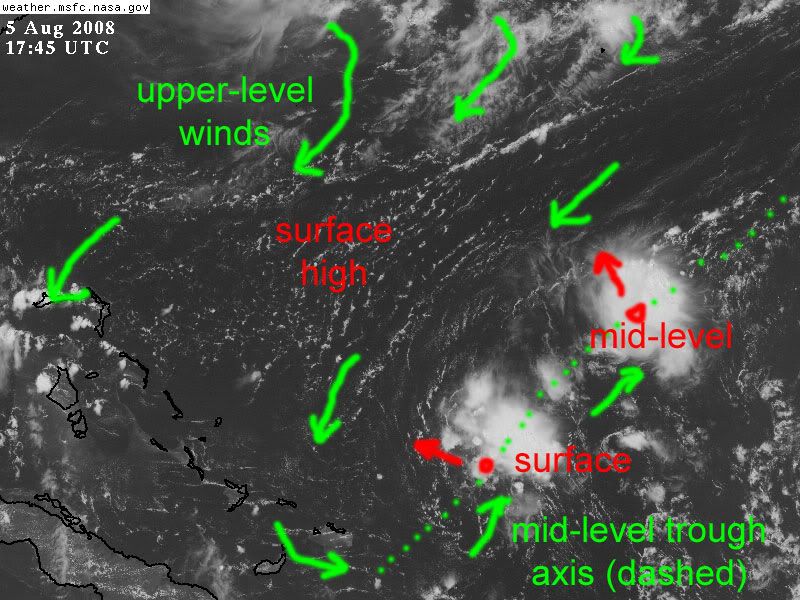
99L is now vertically stacked with a mid-level low trough-axis. A mid-level circulation has developed to the northeast of 99L's surface center, and is moving to the northwest (and should eventually recurve). 99L's surface center will continue in a WNW direction. If Florida is dominated by high-pressure, then 99L should jog westward or even west-southwestward (as low-angle-approaching systems often do in August) around it.
==//==
See also: http://www.nlmoc.navy.mil/cgi-bin/movie ... c+hiresvis
Speed fast, rock-mode (like usual)
Salient feature: Get a load of that jet-streak racing across the northern plains. Upper-level high-pressure is building off the coast, and that streak is only going to reinforce it. In order for 99L to recurve is would have to move into, and then against, southwestward upper-level flow. If 99L develops a persistent vertical presence, that would not be possible.
0 likes
-
Honeyko
Re: Ex Invest 99L in Western Atlantic
That is the extended forecast; it's only Tuesday. By "this weekend", 99L, in whatever state, will have passed Florida.alienstorm wrote:No way this makes it to FLorida or the Gulf of Medxico....
FROM NWS MIAMI
.EXTENDED FORECAST...
THE HIGH WILL CONTINUE TO MOVE SOUTH INTO THE FLORIDA KEYS THIS
WEEKEND INTO EARLY NEXT WEEK[b]...
==//==
http://hadar.cira.colostate.edu/ramsdis ... _ls_0.html
....this does not paint a picture conducive to recurving a storm in the Bahamas (where 99L should be tomorrow). In order to recurve, 99L would have to start moving due north right now.
0 likes
-
SouthFloridawx

- S2K Supporter

- Posts: 8346
- Age: 47
- Joined: Tue Jul 26, 2005 1:16 am
- Location: Sarasota, FL
- Contact:
Re: Ex Invest 99L in Western Atlantic
You can also see what he's talking about on this loop here. You can see the feature moving westward fairly quickly, just ahead of the Sal Outbreak.
http://hadar.cira.colostate.edu/ramsdis/online/trop_ge_vis_float1_0.html

http://hadar.cira.colostate.edu/ramsdis/online/trop_ge_vis_float1_0.html
Last edited by SouthFloridawx on Tue Aug 05, 2008 2:53 pm, edited 1 time in total.
0 likes
-
Honeyko
Re: Ex Invest 99L in Western Atlantic
Pop! There goes the first tropopause overshooter with a symmetrical canopy.
While it was going up, low elements just darted into it from the southeast.
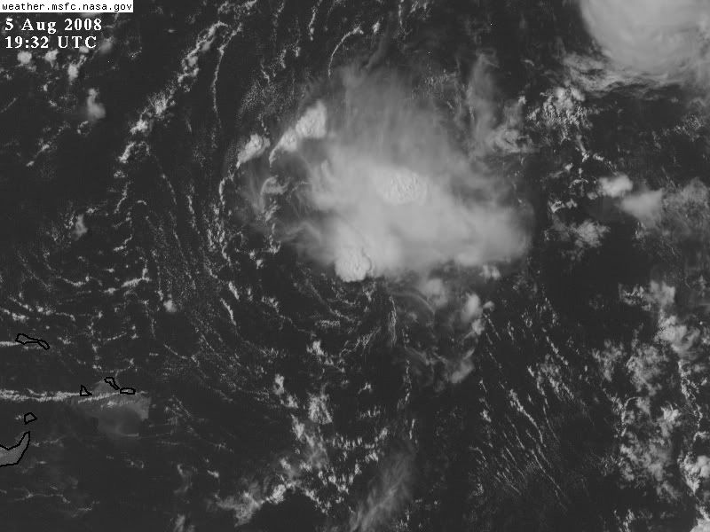
While it was going up, low elements just darted into it from the southeast.
0 likes
-
jhamps10
-
kpost

- Tropical Storm

- Posts: 101
- Age: 48
- Joined: Sun Jul 06, 2008 10:52 am
- Location: Indialantic, Florida (Ohio 4now)
Re: Ex Invest 99L in Western Atlantic
http://euler.atmos.colostate.edu/~vigh/guidance/northatlantic/track_early5.png
if that was the position at 0000UTC then this wave has been well south of the southernmost model line even the XTRP. I have been going on the lat/lon that i have seen on here mostly and eyeballing it. What is wrong here and what is right? I am getting very confused.
I also found this if this is what some models are running why is it not an invest
http://euler.atmos.colostate.edu/~vigh/guidance/northatlantic/intensity_early5.png
0 likes
-
Honeyko
Re: Ex Invest 99L in Western Atlantic
The models are wrong because they do not know how to handle a SAL-driven surface feature decoupled from mid-level steering.
I also expect this be Invested again shortly.
I also expect this be Invested again shortly.
0 likes
-
kpost
- Tropical Storm
- Posts: 101
- Age: 48
- Joined: Sun Jul 06, 2008 10:52 am
- Location: Indialantic, Florida (Ohio 4now)
Re: Ex Invest 99L in Western Atlantic
What about the intensity one, with a possible cat 1 i would think that warrants invest. especially so close to land.
and with the first model what is wrong with it location wise, i would like a grip on where it is.
and with the first model what is wrong with it location wise, i would like a grip on where it is.
0 likes

Re: Ex Invest 99L in Western Atlantic
Yes there is still rotation out there, but the low level pressure gradient must be flat as a frying pan by now? Isn't the lack of any meaningful pressure gradient going to be an important factor that will delay development?
0 likes
-
kpost
- Tropical Storm
- Posts: 101
- Age: 48
- Joined: Sun Jul 06, 2008 10:52 am
- Location: Indialantic, Florida (Ohio 4now)
Re: Ex Invest 99L in Western Atlantic
this is interesting, on the local weather they are say we will have great south-east sea breeze (basically blowing in from where this wave is) and for wend./thurs we will have abnormally low chances of rain 20/30% very low for central florida.
EDIT: they just said high chance of rain it late week to weekend.
EDIT: they just said high chance of rain it late week to weekend.
0 likes
-
alienstorm
- Category 1
- Posts: 496
- Joined: Tue Jul 31, 2007 1:29 pm
- Location: Miami Fla western suburb
Re: Ex Invest 99L in Western Atlantic
This is not going anywhere it's getting shred to pieces, and it is moving NW and then should move off to the north (whatever is left). The NHC knows best and they do not even mentioned this, so I think we should enjoy the lull before the real meat begins in 2 - 3 weeks....
0 likes
-
jhamps10
Re: Ex Invest 99L in Western Atlantic
alienstorm wrote:This is not going anywhere it's getting shred to pieces, and it is moving NW and then should move off to the north (whatever is left). The NHC knows best and they do not even mentioned this, so I think we should enjoy the lull before the real meat begins in 2 - 3 weeks....
ah, I don't think so, looks WNW not NW.
0 likes
-
kpost
- Tropical Storm
- Posts: 101
- Age: 48
- Joined: Sun Jul 06, 2008 10:52 am
- Location: Indialantic, Florida (Ohio 4now)
Re: Ex Invest 99L in Western Atlantic
i wasn't trying to say any thing will be i just thought due to the breeze for us coming from the area of this wave. i would think our chance of rain would be normal or higher not below normal. plus the wave is larger with more convection that it has had in the last while so i would assume since it is not much it would come on the seabreeze and bring some of the rain it keeps producing against all odds and people pronouncing it dead.
Also quick question if it is not a invest why are some models still being ran (marked as L99) as of this morning?
Well i could use some rain, for some reason it comes ashore and skips me and goes inland or crosses the whole state and stops at the river.(i am on the barrier islands)
Also quick question if it is not a invest why are some models still being ran (marked as L99) as of this morning?
Well i could use some rain, for some reason it comes ashore and skips me and goes inland or crosses the whole state and stops at the river.(i am on the barrier islands)
0 likes


Who is online
Users browsing this forum: No registered users and 11 guests