Ex Invest 99L in Western Atlantic

Moderator: S2k Moderators

Message
Author
User avatar
HURAKAN
Professional-Met
Professional-Met
Posts: 46086
Age: 38
Joined: Thu May 20, 2004 4:34 pm
Location: Key West, FL
Contact:

#801 Postby HURAKAN » Tue Aug 05, 2008 7:46 am

Image

No RIP, not yet.
0 likes   

User avatar
HURAKAN
Professional-Met
Professional-Met
Posts: 46086
Age: 38
Joined: Thu May 20, 2004 4:34 pm
Location: Key West, FL
Contact:

#802 Postby HURAKAN » Tue Aug 05, 2008 7:51 am

Image
0 likes   

User avatar
boca
Category 5
Category 5
Posts: 6367
Age: 60
Joined: Mon Dec 15, 2003 8:49 am
Location: Boca Raton,FL

Re: ATL: Ex. 99L in Western Atlantic

#803 Postby boca » Tue Aug 05, 2008 7:56 am

It has better conditions today than it had the last couple of days.It also has an s shaped signature to it and its still moving WNW,but they said it would turn north and break off.
0 likes   

User avatar
boca
Category 5
Category 5
Posts: 6367
Age: 60
Joined: Mon Dec 15, 2003 8:49 am
Location: Boca Raton,FL

Re: ATL: Ex. 99L in Western Atlantic

#804 Postby boca » Tue Aug 05, 2008 8:05 am

Hey Sandy our ex99L is still alive. I'm not sure if it will continue moving WNW or turn north.

http://metofis.rsmas.miami.edu/~dortt/s ... 1_loop.gif
0 likes   

User avatar
kpost
Tropical Storm
Tropical Storm
Posts: 101
Age: 48
Joined: Sun Jul 06, 2008 10:52 am
Location: Indialantic, Florida (Ohio 4now)

Re: Ex Invest 99L in Western Atlantic

#805 Postby kpost » Tue Aug 05, 2008 8:07 am

Its DEAD, Its ALIVE. this thing needs to make up its mind.
0 likes   

User avatar
HURAKAN
Professional-Met
Professional-Met
Posts: 46086
Age: 38
Joined: Thu May 20, 2004 4:34 pm
Location: Key West, FL
Contact:

#806 Postby HURAKAN » Tue Aug 05, 2008 8:08 am

Lower levels:

Image

Upper levels:

Image

Don't know why it should move northward if it stays weak.
0 likes   

User avatar
HURAKAN
Professional-Met
Professional-Met
Posts: 46086
Age: 38
Joined: Thu May 20, 2004 4:34 pm
Location: Key West, FL
Contact:

Re: Ex Invest 99L in Western Atlantic

#807 Postby HURAKAN » Tue Aug 05, 2008 8:09 am

kpost wrote:Its DEAD, Its ALIVE. this thing needs to make up its mind.


Since it left Africa it has been alive. Sometimes it was in hibernation, but alive!!!
0 likes   

User avatar
storms in NC
S2K Supporter
S2K Supporter
Posts: 2338
Joined: Thu Jul 28, 2005 2:58 pm
Location: Wallace,NC 40 miles NE of Wilm
Contact:

Re: Ex Invest 99L in Western Atlantic

#808 Postby storms in NC » Tue Aug 05, 2008 8:10 am

kpost wrote:Its DEAD, Its ALIVE. this thing needs to make up its mind.


I think it is Dead.There is not any kind of blow up going on at all. just a wave.
0 likes   

User avatar
boca
Category 5
Category 5
Posts: 6367
Age: 60
Joined: Mon Dec 15, 2003 8:49 am
Location: Boca Raton,FL

Re:

#809 Postby boca » Tue Aug 05, 2008 8:13 am

HURAKAN wrote:Lower levels:

Image

Upper levels:

Image

Don't know why it should move northward if it stays weak.


They said it in the two discussion. It looks like convection is increasing and I think we have to watch this more carefully.
0 likes   

User avatar
kpost
Tropical Storm
Tropical Storm
Posts: 101
Age: 48
Joined: Sun Jul 06, 2008 10:52 am
Location: Indialantic, Florida (Ohio 4now)

Re: Ex Invest 99L in Western Atlantic

#810 Postby kpost » Tue Aug 05, 2008 8:14 am

This one has been fun to watch, it seems very emotional. I have been watching this one from the beginning, for no apparent reason (i have little knowledge on the subject) other then a gut feeling. so once again here is the screen that has been up on my computer http://www.atmos.washington.edu/~ovens/loops/wxloop.cgi?wv_east_enhanced+12 it updates every hour so other then you guys it has been most of my info regarding her (l99) fits.
0 likes   

User avatar
kpost
Tropical Storm
Tropical Storm
Posts: 101
Age: 48
Joined: Sun Jul 06, 2008 10:52 am
Location: Indialantic, Florida (Ohio 4now)

Re: Ex Invest 99L in Western Atlantic

#811 Postby kpost » Tue Aug 05, 2008 8:20 am

HURAKAN-

Quick question. On your site you have a Invest 93L listed and on Derek Ortt's site he has L06. i posted about his and was told to ignore it. But what are they? they both seem to be about EX l99.

PS
You have a nice site.
0 likes   

User avatar
BensonTCwatcher
Category 5
Category 5
Posts: 1046
Joined: Sat Aug 28, 2004 10:11 pm
Location: Southport NC

Re: Ex Invest 99L in Western Atlantic

#812 Postby BensonTCwatcher » Tue Aug 05, 2008 8:27 am

Boy looking at this drama queen early today, I'd say it was dead, but on MSFC sat shots I still see a LLC. It looks more like a sharp wave ( and a weak) and Quickscat pass missed it. I was actually hoping it went poof, now I be drawn into checking on the bride of frankenstein today. Keep the good doctor away from the switch please... :roll:
0 likes   

cpdaman
Category 5
Category 5
Posts: 3131
Joined: Sat Jun 10, 2006 11:44 am
Location: SPB county (gulf stream)

Re: Ex Invest 99L in Western Atlantic

#813 Postby cpdaman » Tue Aug 05, 2008 8:35 am

it has had two near death experiences

now on to some legitimate questions

What is the real shear this thing is enduring, i honestly think those CIMSS shear charts can be off sometimes, so in situations where a TUTT is near by i don't trust the shear forecasts, and i don't really know enough yet from just looking at the WV, IR,VIS wether there is decreasing shear yet or not. appeared last nite the ULL was moving in tandem and just prolonging the shearing/torture process. latest WV shows me that perhaps this little bugger has made it west enough of the SW shear around the base of the ull/tutt (which also appears to be weakening) however on second look i don't think it has although completely (although prob less sw shear now) and the flow just NW of the storm appears to be ENE (and that flow appears to be collapsing toward ex99, so i don't think the ULL sw shear will recatch it (should that rambling make sense) , yesterday it fired some convection for a couple hours that was blown to the north. let's see what today brings
0 likes   
User avatar
HURAKAN
Professional-Met
Professional-Met
Posts: 46086
Age: 38
Joined: Thu May 20, 2004 4:34 pm
Location: Key West, FL
Contact:

#814 Postby HURAKAN » Tue Aug 05, 2008 8:45 am

Image
0 likes   

Frank2
Category 5
Category 5
Posts: 4061
Joined: Mon Jul 25, 2005 12:47 pm

Re: Ex Invest 99L in Western Atlantic

#815 Postby Frank2 » Tue Aug 05, 2008 8:49 am

Nice photo of two thunderstorms...

The SAL is very widespread at this time, covering most of the Tropical Atlantic, so...
0 likes   

cpdaman
Category 5
Category 5
Posts: 3131
Joined: Sat Jun 10, 2006 11:44 am
Location: SPB county (gulf stream)

Re: Ex Invest 99L in Western Atlantic

#816 Postby cpdaman » Tue Aug 05, 2008 8:56 am

the scary Sal monster.....crikey

where a good sal link the one i'm on at CIMSS seems to only get to 60w
0 likes   

Steve H.
Category 5
Category 5
Posts: 2146
Joined: Sat Oct 19, 2002 9:06 am
Location: Palm Bay, Florida

Re: Ex Invest 99L in Western Atlantic

#817 Postby Steve H. » Tue Aug 05, 2008 9:02 am

I don't know. It seems like the ULL is ventilating 99L, which now appears to be developing some decent convection. I think the portion that was going to get sucked north with the NE/SW oriented TUTT has been taken, and the LLC is going to continue on a WNW track. Might be an interesting day for the EX. Seems I can sense an overall spark in the tropics again today across the Atlantic basin. Hopefully that spark will get dimmed - but we're entering the active part of the season in the next few weeks. :cry:
0 likes   

shortwave
S2K Supporter
S2K Supporter
Posts: 156
Age: 53
Joined: Mon May 24, 2004 5:56 pm
Location: palm bay, fl.

#818 Postby shortwave » Tue Aug 05, 2008 9:07 am

This one has at best been able to produce some short bursts of spotted convection.
At the same time while upper level winds and some dry air are not favorable it does seem like it could POSSIBLY, hold on to and produce more convection.
What I've been looking at is at the top portion of the wave where there seems to be maybe a piece of the energy seperating from the low level swirl that we have been following.
http://www.atmos.washington.edu/~ovens/ ... st_full+12
Hard to say what will exactly happen, but a lot of fun to watch.
0 likes   

User avatar
cycloneye
Admin
Admin
Posts: 145303
Age: 68
Joined: Thu Oct 10, 2002 10:54 am
Location: San Juan, Puerto Rico

Re: Ex Invest 99L in Western Atlantic

#819 Postby cycloneye » Tue Aug 05, 2008 9:09 am

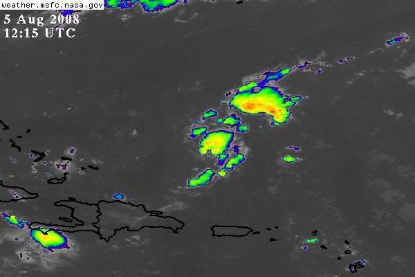
Does not look bad at all.

Image
0 likes   

User avatar
Tampa Bay Hurricane
Category 5
Category 5
Posts: 5597
Age: 37
Joined: Fri Jul 22, 2005 7:54 pm
Location: St. Petersburg, FL

Re: Ex Invest 99L in Western Atlantic

#820 Postby Tampa Bay Hurricane » Tue Aug 05, 2008 9:20 am

Assuming this disturbance stays weak and continues WNW, when would
the moisture from it reach Florida?

I DO NOT want any tropical system, but some tropical moisture and rain
without severe weather would be nice.
0 likes   


Return to “2008”

Who is online

Users browsing this forum: No registered users and 4 guests