Ex Invest 99L in Western Atlantic
Moderator: S2k Moderators
-
cycloneye

- Admin

- Posts: 149298
- Age: 69
- Joined: Thu Oct 10, 2002 10:54 am
- Location: San Juan, Puerto Rico
Re: ATL: Invest 99L in Western Atlantic
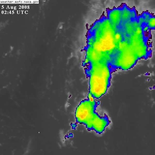
It has been a fighter against all the hostile enviroment possible that you can imagine,cool waters as it moved off Africa,sal entrainment,dry air,prohibitive shear,but against all that its still there.
0 likes
-
Honeyko
Re: ATL: Invest 99L in Western Atlantic
The convection at the north end of the system, where a mid-level circulation might have developed, is dying away.Honeyko wrote:http://www.nlmoc.navy.mil/cgi-bin/movie.pl?satellite+jpg+10tttt+1200+1600+north_atlantic+hiresir
Assuming convection persists now, one of three things happens:
1) A mid-level circulation develops and is shoved north by shear. Result: Developing, recurving system.
2) The low center continues WNW and the upper-low retrogrades west quickly and remains strong: Result: 99L remains sheared....status quo.
3) The low center continues WNW and the upper-low retrogrades slowly or drops southwest. Result: 99L's surface center stacks with a 300mb upper trough. Explosive development as tropopause-overshooting CBs exhaust into excellent divergence.
2 and 3 remain....
==//==
Things that make you go, "Hmm....":

0 likes
Re: ATL: Invest 99L in Western Atlantic
the rita reference was good for a laugh
of note it appears 99L is having another near death experience, not sure if she'll have a LLC by morning (or even still now)
http://www.ssd.noaa.gov/goes/flt/t1/loop-ir2.html
me thinks this is the end of the road
of note it appears 99L is having another near death experience, not sure if she'll have a LLC by morning (or even still now)
http://www.ssd.noaa.gov/goes/flt/t1/loop-ir2.html
me thinks this is the end of the road
Last edited by cpdaman on Tue Aug 05, 2008 1:01 am, edited 1 time in total.
0 likes
-
fasterdisaster
- Category 5

- Posts: 1868
- Joined: Mon Sep 19, 2005 4:41 pm
- Location: Miami, Florida
-
Honeyko
Re: ATL: Invest 99L in Western Atlantic
Rita developed out of a "it'll never amount to anything" system just like this one.cpdaman wrote:the rita reference was good for a laugh
That floater is busted. Try this one instead: http://www.ssd.noaa.gov/goes/east/watl/loop-ir2.html ....zot the bad frames, fast rock mode, then click the Zoom button and hit a spot north of the system.http://www.ssd.noaa.gov/goes/flt/t1/loop-ir2.html
0 likes
-
jhamps10
-
Honeyko
Re: ATL: Invest 99L in Central Atlantic
Eyeball-projected (from IR2) 0805 0845Z center-fix: 22.5N/66W. W/WNW heading continues.Honeyko wrote:Eyeball-projected 0804 1930Z center-fix: just a sliver southeast of 22N/62W. WNW heading. SAL still to the east, barging it forward.
0 likes
Re: ATL: Invest 99L in Western Atlantic
The Puerto Rico imagery gives a closer look at this feature http://www.ssd.noaa.gov/goes/east/pr/loop-ir2.html. Looking at the upper air charts I don't see the shear backing off for at least 48 hrs.
0 likes
-
storms in NC

- S2K Supporter

- Posts: 2338
- Joined: Thu Jul 28, 2005 2:58 pm
- Location: Wallace,NC 40 miles NE of Wilm
- Contact:
-
Gustywind

- Category 5
- Posts: 12334
- Joined: Mon Sep 03, 2007 7:29 am
- Location: Baie-Mahault, GUADELOUPE
000
AXNT20 KNHC 050604
TWDAT
TROPICAL WEATHER DISCUSSION
NWS TPC/NATIONAL HURRICANE CENTER MIAMI FL
205 AM EDT TUE AUG 05 2008
TROPICAL WEATHER DISCUSSION FOR NORTH AMERICA...CENTRAL
AMERICA...GULF OF MEXICO...CARIBBEAN SEA...NORTHERN SECTIONS
OF SOUTH AMERICA...AND ATLANTIC OCEAN TO THE AFRICAN COAST
FROM THE EQUATOR TO 32N. THE FOLLOWING INFORMATION IS BASED
ON SATELLITE IMAGERY...METEOROLOGICAL ANALYSIS...WEATHER
OBSERVATIONS...AND RADAR.
BASED ON 0000 UTC SURFACE ANALYSIS AND SATELLITE IMAGERY THROUGH
0515 UTC.
A HIGH AMPLITUDE TROPICAL WAVE HAS ENTERED THE E CARIBBEAN. ITS
AXIS EXTENDS ALONG 63W S OF 26N MOVING W 20-25 KT. A WEAK 1014
MB LOW IS ALONG THE WAVE AXIS NEAR 22N. SCATTERED MODERATE
CONVECTION IS ON THE NORTHERN END OF THE WAVE FROM 21N-26N
BETWEEN 62W-66W. THE WAVE IS ALSO GENERATING SOME SHOWER
ACTIVITY OVER THE WINDWARD ISLANDS AND NE VENEZUELA. WHILE THE N
PART OF THE WAVE IS FORECAST TO BREAK AWAY AND MOVE NWD...THE
REMAINDER OF THE WAVE WILL CONTINUE TO MOVE WWD ACROSS THE E
CARIBBEAN SPREADING ITS MOISTURE OVER THE UK/US VIRGIN ISLANDS
AND PUERTO RICO.
0 likes


-
HURAKAN

- Professional-Met

- Posts: 46084
- Age: 39
- Joined: Thu May 20, 2004 4:34 pm
- Location: Key West, FL
- Contact:
Adios:
BEGIN
NHC
invest_DEACTIVATE_al992008.ren
FSTDA
R
U
040
010
0000
200808051107
NONE
NOTIFY=ATRP
END
INVEST, AL, L, , , , , 99, 2008, DB, O, 2008080112, 9999999999, , , , , , METWATCH, , AL992008
AL, 99, 2008072918, , BEST, 0, 137N, 172W, 20, 1008, DB, 0, , 0, 0, 0, 0,
AL, 99, 2008073000, , BEST, 0, 144N, 179W, 20, 1008, DB, 0, , 0, 0, 0, 0,
AL, 99, 2008073006, , BEST, 0, 146N, 189W, 20, 1007, DB, 0, , 0, 0, 0, 0,
AL, 99, 2008073012, , BEST, 0, 154N, 198W, 25, 1008, DB, 0, , 0, 0, 0, 0,
AL, 99, 2008073018, , BEST, 0, 165N, 215W, 25, 1008, DB, 0, , 0, 0, 0, 0,
AL, 99, 2008073100, , BEST, 0, 169N, 232W, 25, 1007, DB, 0, , 0, 0, 0, 0,
AL, 99, 2008073106, , BEST, 0, 176N, 250W, 25, 1007, DB, 0, , 0, 0, 0, 0,
AL, 99, 2008073112, , BEST, 0, 178N, 269W, 25, 1008, DB, 0, , 0, 0, 0, 0,
AL, 99, 2008073118, , BEST, 0, 180N, 290W, 25, 1008, DB, 0, , 0, 0, 0, 0,
AL, 99, 2008080100, , BEST, 0, 184N, 314W, 25, 1008, DB, 0, , 0, 0, 0, 0,
AL, 99, 2008080106, , BEST, 0, 185N, 334W, 25, 1008, DB, 0, , 0, 0, 0, 0,
AL, 99, 2008080112, , BEST, 0, 184N, 354W, 25, 1008, DB, 0, , 0, 0, 0, 0, 1010, 150, 45, 0, 0, L, 0, , 0, 0, INVEST, S,
AL, 99, 2008080118, , BEST, 0, 184N, 375W, 25, 1008, DB, 0, , 0, 0, 0, 0,
AL, 99, 2008080200, , BEST, 0, 183N, 389W, 25, 1008, DB, 0, , 0, 0, 0, 0, 1010, 150, 45, 0, 0, L, 0, , 0, 0, INVEST, S,
AL, 99, 2008080206, , BEST, 0, 187N, 414W, 25, 1008, DB, 0, , 0, 0, 0, 0,
AL, 99, 2008080212, , BEST, 0, 187N, 430W, 30, 1008, DB, 0, , 0, 0, 0, 0, 1012, 150, 45, 0, 0, L, 0, , 0, 0, INVEST, M,
AL, 99, 2008080218, , BEST, 0, 186N, 445W, 30, 1010, DB, 0, , 0, 0, 0, 0, 1012, 150, 45, 0, 0, L, 0, , 0, 0, INVEST, M,
AL, 99, 2008080300, , BEST, 0, 185N, 465W, 30, 1010, DB, 0, , 0, 0, 0, 0, 1012, 150, 45, 0, 0, L, 0, , 0, 0, INVEST, M,
AL, 99, 2008080306, , BEST, 0, 184N, 483W, 30, 1010, DB, 0, , 0, 0, 0, 0, 1012, 150, 45, 0, 0, L, 0, , 0, 0, INVEST, M,
AL, 99, 2008080312, , BEST, 0, 188N, 504W, 30, 1010, DB, 0, , 0, 0, 0, 0, 1012, 150, 45, 0, 0, L, 0, , 0, 0, INVEST, M,
AL, 99, 2008080318, , BEST, 0, 193N, 524W, 25, 1010, DB, 0, , 0, 0, 0, 0, 1012, 150, 45, 0, 0, L, 0, , 0, 0, INVEST, M,
AL, 99, 2008080400, , BEST, 0, 195N, 543W, 25, 1012, DB, 0, , 0, 0, 0, 0, 1013, 150, 45, 0, 0, L, 0, , 0, 0, INVEST, M,
AL, 99, 2008080406, , BEST, 0, 197N, 562W, 25, 1012, DB, 0, , 0, 0, 0, 0,
AL, 99, 2008080412, , BEST, 0, 203N, 588W, 25, 1012, DB, 0, , 0, 0, 0, 0,
AL, 99, 2008080418, , BEST, 0, 215N, 615W, 25, 1013, DB, 0, , 0, 0, 0, 0, 1013, 150, 45, 0, 0, L, 0, , 0, 0, INVEST, M,
AL, 99, 2008080500, , BEST, 0, 218N, 628W, 25, 1013, DB, 34, NEQ, 0, 0, 0, 0, 1014, 150, 45, 0, 0, L, 0, , 0, 0, INVEST, M,
0 likes
-
bvigal

- S2K Supporter
- Posts: 2276
- Joined: Sun Jul 24, 2005 8:49 am
- Location: British Virgin Islands
- Contact:
Re: ATL: Invest 99L in Western Atlantic
FINALLY, officially put to rest! "Low, meet TUTT"
from http://www.srh.noaa.gov/productview.php?pil=SJUAFDSJU&version=0
...."THE TROPICAL WAVE ACROSS THE EASTERN (CARIBBEAN) THIS MORNING...WILL
CONTINUE TO MOVE WESTWARD ACROSS THE LOCAL REGION TODAY AND TONIGHT.
LATEST SATELLITE IMAGES THIS MORNING INDICATED MODERATE CONVECTION
ON THE NORTHERN AND SOUTHERN END OF THE WAVE WITH LIMITED CONVECTION
ELSEWHERE. MODEL GUIDANCES...AS INDICATED IN THE PREVIOUS
DISCUSSION...SUGGESTS THAT THE EFFECTS OF THIS SYSTEM ACROSS THE
REGION WILL BE MINIMAL. MOST OF THE WEATHER TODAY AND TONIGHT WILL
BE DICTATED BY AN UPPER LEVEL TROUGH (TUTT) ORIENTED NORTH TO SOUTH
AND EXTENDING FROM THE COAST OF SOUTH AMERICA NORTHWARD ACROSS
HISPANIOLA AND CONTINUING NORTHWARD ACROSS THE ATLANTIC FOR
SEVERAL HUNDREDS MILES."
0 likes
Re: ATL: Ex. 99L in Western Atlantic
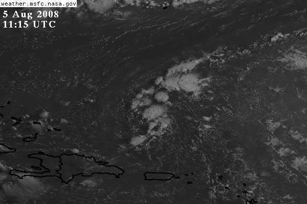
If you look on that map there is one small area of 20kt near Puerto Rico, I think that is what was getting it overnight. You could definitely see the cirrus flying in IR2. It is easier to see in a loop than a still.If this is correct, windshear is not a problem for 99L. I think the visible image above shows that the convective areas are not being sheared.
0 likes
-
storms in NC
- S2K Supporter
- Posts: 2338
- Joined: Thu Jul 28, 2005 2:58 pm
- Location: Wallace,NC 40 miles NE of Wilm
- Contact:
-
HURAKAN
- Professional-Met
- Posts: 46084
- Age: 39
- Joined: Thu May 20, 2004 4:34 pm
- Location: Key West, FL
- Contact:
TROPICAL WEATHER DISCUSSION
NWS TPC/NATIONAL HURRICANE CENTER MIAMI FL
805 AM EDT TUE AUG 05 2008
A HIGH AMPLITUDE TROPICAL WAVE IS OVER THE E CARIBBEAN WITH AXIS
ALONG 65W S OF 25N MOVING W 20-25 KT. WIDELY SCATTERED MODERATE
CONVECTION IS ON THE NORTHERN END OF THE WAVE FROM 22N-27N
BETWEEN 63W-68W. SIMILAR CONVECTION IS OVER THE WINDWARD ISLANDS
FROM 10N-15N BETWEEN 60W-67W. THE N PART OF THE WAVE IS FORECAST
TO BREAK AWAY AND MOVE NWD...THE REMAINDER OF THE WAVE WILL
CONTINUE TO MOVE WWD ACROSS THE E CARIBBEAN.
0 likes
Who is online
Users browsing this forum: No registered users and 57 guests