Ex Invest 99L in Western Atlantic

Moderator: S2k Moderators

Message
Author
User avatar
boca
Category 5
Category 5
Posts: 6367
Age: 60
Joined: Mon Dec 15, 2003 8:49 am
Location: Boca Raton,FL

Re: Re:

#681 Postby boca » Sun Aug 03, 2008 11:33 pm

Blown_away wrote:
fasterdisaster wrote:I think it's possible but not likely. I also think a recurve is all but certain now.


Based on what?


I think its based on how fast 99L is moving and how fast the trough will move into the SE US to change the steering flow around 99L. Also if 99L stays weak then decides to develop in the Bahamas it will be a problem because if its weak the low levels are easterly.If it develops say tomorrow the better chance of a recurve like the models have been trying to say even though it hasn't happened.
0 likes   

User avatar
Blown Away
S2K Supporter
S2K Supporter
Posts: 10145
Joined: Wed May 26, 2004 6:17 am

Re: Re:

#682 Postby Blown Away » Sun Aug 03, 2008 11:50 pm

boca wrote:
Blown_away wrote:
fasterdisaster wrote:I think it's possible but not likely. I also think a recurve is all but certain now.


Based on what?


I think its based on how fast 99L is moving and how fast the trough will move into the SE US to change the steering flow around 99L. Also if 99L stays weak then decides to develop in the Bahamas it will be a problem because if its weak the low levels are easterly.If it develops say tomorrow the better chance of a recurve like the models have been trying to say even though it hasn't happened.


With dry air to the W and the TUTT to the NW, development within the next 30 hours seems unlikely. After that the system will be just E of the SE Bahamas and conditions should improve. It has to survive the trip.
0 likes   

User avatar
boca
Category 5
Category 5
Posts: 6367
Age: 60
Joined: Mon Dec 15, 2003 8:49 am
Location: Boca Raton,FL

Re: ATL: Invest 99L in Central Atlantic

#683 Postby boca » Sun Aug 03, 2008 11:52 pm

It looks like the cloud tops are starting to warm again on the last frames.
0 likes   

User avatar
boca
Category 5
Category 5
Posts: 6367
Age: 60
Joined: Mon Dec 15, 2003 8:49 am
Location: Boca Raton,FL

Re: ATL: Invest 99L in Central Atlantic

#684 Postby boca » Mon Aug 04, 2008 12:01 am

In the water vapor image the ULL is moving NNW and the dry air is getting smaller so 99L might have more moisture to work with and its still moving due west.

http://metofis.rsmas.miami.edu/~dortt/s ... 1_loop.gif
0 likes   

SapphireSea
Category 1
Category 1
Posts: 430
Joined: Wed Aug 24, 2005 12:13 pm
Location: Miami, FL

Re: ATL: Invest 99L in Central Atlantic

#685 Postby SapphireSea » Mon Aug 04, 2008 2:32 am

I don't see anything anymore in terms of circulation associated with 99L, this could be dropped or go to TOO WEAK in estimates by morning. This may be the end, unless something is more evident on visible.
0 likes   

User avatar
HURAKAN
Professional-Met
Professional-Met
Posts: 46086
Age: 38
Joined: Thu May 20, 2004 4:34 pm
Location: Key West, FL
Contact:

#686 Postby HURAKAN » Mon Aug 04, 2008 3:03 am

TROPICAL WEATHER OUTLOOK
NWS TPC/NATIONAL HURRICANE CENTER MIAMI FL
200 AM EDT MON AUG 4 2008

FOR THE NORTH ATLANTIC...CARIBBEAN SEA AND THE GULF OF MEXICO...

THE NATIONAL HURRICANE CENTER IS ISSUING ADVISORIES ON TROPICAL
STORM EDOUARD...LOCATED ABOUT 325 MILES EAST-SOUTHEAST OF GALVESTON
TEXAS.

SHOWER ACTIVITY ASSOCIATED WITH A LOW PRESSURE AREA CENTERED ABOUT
450 MILES EAST-NORTHEAST OF THE NORTHERN LEEWARD ISLANDS REMAINS
POORLY ORGANIZED. UPPER-LEVEL WINDS ARE BECOMING LESS FAVORABLE
AND SIGNIFICANT DEVELOPMENT OF THIS SYSTEM IS NOT EXPECTED AS IT
MOVES TOWARD THE WEST-NORTHWEST AT 15 TO 20 MPH.

ELSEWHERE...TROPICAL CYCLONE FORMATION IS NOT EXPECTED DURING THE
NEXT 48 HOURS.
0 likes   

User avatar
KWT
Category 5
Category 5
Posts: 31415
Joined: Tue Aug 17, 2004 11:02 am
Location: UK!!!

#687 Postby KWT » Mon Aug 04, 2008 4:12 am

Looks like it should be getting hit by shear now which is probably why the TWO is mentioning a less favorable upper set-up.
0 likes   

User avatar
HURAKAN
Professional-Met
Professional-Met
Posts: 46086
Age: 38
Joined: Thu May 20, 2004 4:34 pm
Location: Key West, FL
Contact:

#688 Postby HURAKAN » Mon Aug 04, 2008 5:12 am

Image
0 likes   

User avatar
HURAKAN
Professional-Met
Professional-Met
Posts: 46086
Age: 38
Joined: Thu May 20, 2004 4:34 pm
Location: Key West, FL
Contact:

#689 Postby HURAKAN » Mon Aug 04, 2008 5:17 am

Image
0 likes   

User avatar
KWT
Category 5
Category 5
Posts: 31415
Joined: Tue Aug 17, 2004 11:02 am
Location: UK!!!

#690 Postby KWT » Mon Aug 04, 2008 5:18 am

It look too bad right now as it happens, i'm guessing any center is under that deeper convection?
0 likes   

User avatar
HURAKAN
Professional-Met
Professional-Met
Posts: 46086
Age: 38
Joined: Thu May 20, 2004 4:34 pm
Location: Key West, FL
Contact:

#691 Postby HURAKAN » Mon Aug 04, 2008 5:33 am

AL, 99, 2008080406, , BEST, 0, 197N, 562W, 25, 1012,
0 likes   

User avatar
HURAKAN
Professional-Met
Professional-Met
Posts: 46086
Age: 38
Joined: Thu May 20, 2004 4:34 pm
Location: Key West, FL
Contact:

#692 Postby HURAKAN » Mon Aug 04, 2008 5:36 am

Image

Image

First real visible.
0 likes   

User avatar
HURAKAN
Professional-Met
Professional-Met
Posts: 46086
Age: 38
Joined: Thu May 20, 2004 4:34 pm
Location: Key West, FL
Contact:

#693 Postby HURAKAN » Mon Aug 04, 2008 6:04 am

Image

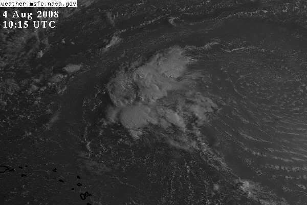
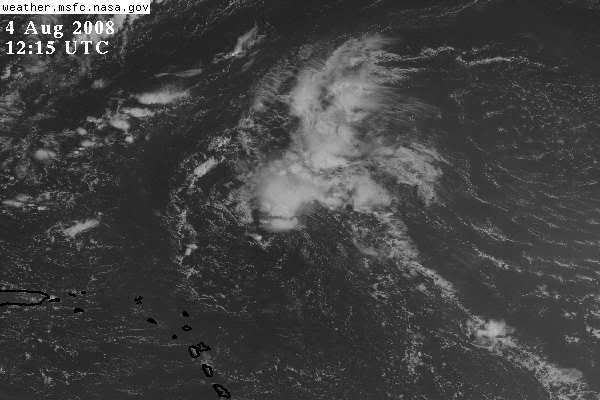
If the circulation is at 19.7ºN 56.2ºW, then the convection is hundreds of miles to the north.
0 likes   

Matt-hurricanewatcher

Re: ATL: Invest 99L in Central Atlantic

#694 Postby Matt-hurricanewatcher » Mon Aug 04, 2008 6:08 am

I believe the LLC is under that small blow up on the southern side of the convection. You can see inflow nicely.
0 likes   

User avatar
HURAKAN
Professional-Met
Professional-Met
Posts: 46086
Age: 38
Joined: Thu May 20, 2004 4:34 pm
Location: Key West, FL
Contact:

Re: ATL: Invest 99L in Central Atlantic

#695 Postby HURAKAN » Mon Aug 04, 2008 6:10 am

Matt-hurricanewatcher wrote:I believe the LLC is under that small blow up on the southern side of the convection. You can see inflow nicely.


I agree. Closer look:

Image
0 likes   

User avatar
KWT
Category 5
Category 5
Posts: 31415
Joined: Tue Aug 17, 2004 11:02 am
Location: UK!!!

#696 Postby KWT » Mon Aug 04, 2008 6:13 am

Yep i agree with that, wonder if it will hold the convection in place this time round. The thying is with this thing staying weak if it does decide to eventually do something it could be a real threat to the USA, though it has lifted up a little recently.
0 likes   

User avatar
boca
Category 5
Category 5
Posts: 6367
Age: 60
Joined: Mon Dec 15, 2003 8:49 am
Location: Boca Raton,FL

Re: ATL: Invest 99L in Central Atlantic

#697 Postby boca » Mon Aug 04, 2008 6:59 am

99L has recurve wriiten on its forehead due to the ULL to its NW pulling it that way.Also another trough will be along the east coast by late this week. As long as we have this trough along the east coast nothing will threaten the US from the SE.
0 likes   

User avatar
HURAKAN
Professional-Met
Professional-Met
Posts: 46086
Age: 38
Joined: Thu May 20, 2004 4:34 pm
Location: Key West, FL
Contact:

#698 Postby HURAKAN » Mon Aug 04, 2008 7:40 am

Image

Image
0 likes   

User avatar
HURAKAN
Professional-Met
Professional-Met
Posts: 46086
Age: 38
Joined: Thu May 20, 2004 4:34 pm
Location: Key West, FL
Contact:

#699 Postby HURAKAN » Mon Aug 04, 2008 7:42 am

TROPICAL WEATHER OUTLOOK
NWS TPC/NATIONAL HURRICANE CENTER MIAMI FL
800 AM EDT MON AUG 4 2008

FOR THE NORTH ATLANTIC...CARIBBEAN SEA AND THE GULF OF MEXICO...

THE NATIONAL HURRICANE CENTER IS ISSUING ADVISORIES ON TROPICAL
STORM EDOUARD...LOCATED ABOUT 295 MILES EAST-SOUTHEAST OF GALVESTON
TEXAS.

SHOWER ACTIVITY ASSOCIATED WITH A TROUGH OF LOW PRESSURE A FEW
HUNDRED MILES NORTHEAST OF THE NORTHERN LEEWARD ISLANDS REMAINS
POORLY ORGANIZED. UPPER-LEVEL WINDS ARE BECOMING LESS FAVORABLE
FOR DEVELOPMENT...AND TROPICAL CYCLONE FORMATION IS NOT EXPECTED
HERE OR ELSEWHERE DURING THE NEXT 48 HOURS.

$$
FORECASTER FRANKLIN
0 likes   

Ed Mahmoud

Re: ATL: Invest 99L in Central Atlantic

#700 Postby Ed Mahmoud » Mon Aug 04, 2008 8:01 am

boca wrote:99L has recurve wriiten on its forehead due to the ULL to its NW pulling it that way.Also another trough will be along the east coast by late this week. As long as we have this trough along the east coast nothing will threaten the US from the SE.


I don't think Bermuda can let their guard down yet.
0 likes   


Return to “2008”

Who is online

Users browsing this forum: No registered users and 1 guest