Invest not official yet, but here is the recon for GOM
NOUS42 KNHC 021530
WEATHER RECONNAISSANCE FLIGHTS
CARCAH, NATIONAL HURRICANE CENTER, MIAMI, FL.
1130 AM EDT SAT 02 AUGUST 2008
SUBJECT: TROPICAL CYCLONE PLAN OF THE DAY (TCPOD)
VALID 03/1100Z TO 04/1100Z AUGUST 2008
TCPOD NUMBER.....08-063
I. ATLANTIC REQUIREMENTS
1. SUSPECT AREA --GULF OF MEXICO
FLIGHT ONE TEAL 70 FLIGHT TWO --TEAL 71
A. 03/1800Z A. 04/0600Z-1200Z
B. AFXXX 01BBA INVEST B. AFXXX 0205A CYCLONE
C. 03/1600Z C. 04/0400Z
D. 28.5N 86.5W D. 28.2N 88.0W
E. 03/1700 TO 04/0000Z E. 04/0500 TO 1200Z
F. SFC TO 10,000FT F. SFC TO 10,000FT
2. SUCCEEDING DAY OUTLOOK: CONTINUE 6 HRLY FIXES IF SYSTEM
DEVELOPS.
11. PACIFIC REQUIREMENTS
1. NEGATIVE RECONNAISSANCE REQUIREMENTS.
2. SUCCEEDING DAY OUTLOOK.....NEGATIVE.
WVW
Ex Invest 99L in Western Atlantic
Moderator: S2k Moderators
-
dixiebreeze

- S2K Supporter

- Posts: 5140
- Joined: Wed Sep 03, 2003 5:07 pm
- Location: crystal river, fla.


-
fasterdisaster
- Category 5

- Posts: 1868
- Joined: Mon Sep 19, 2005 4:41 pm
- Location: Miami, Florida
-
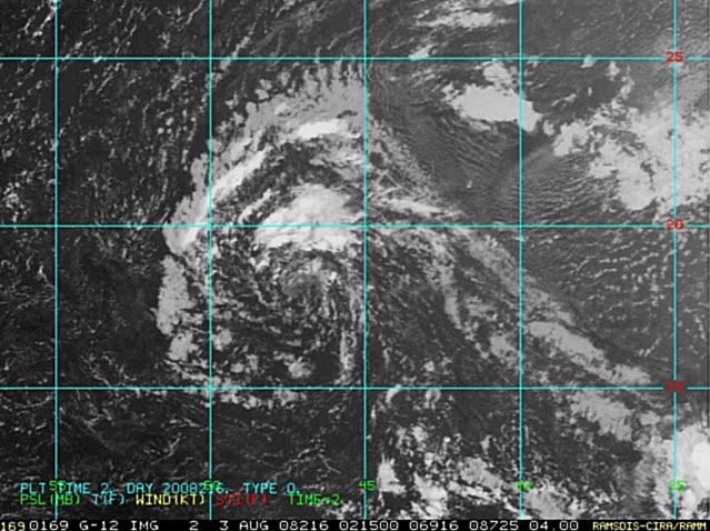
Matt-hurricanewatcher
Re: ATL: Invest 99L in Central Atlantic
http://www.cira.colostate.edu/cira/RAMM ... pical.html
It is clear to me that a westly flow is close to the surface. Needs a little more convection in then it should be a depression.
18.4/45.5
It is clear to me that a westly flow is close to the surface. Needs a little more convection in then it should be a depression.
18.4/45.5
0 likes
-
cycloneye
- Admin

- Posts: 149306
- Age: 69
- Joined: Thu Oct 10, 2002 10:54 am
- Location: San Juan, Puerto Rico
Re: ATL: Invest 99L in Central Atlantic
ABNT20 KNHC 022352
TWOAT
TROPICAL WEATHER OUTLOOK
NWS TPC/NATIONAL HURRICANE CENTER MIAMI FL
800 PM EDT SAT AUG 2 2008
FOR THE NORTH ATLANTIC...CARIBBEAN SEA AND THE GULF OF MEXICO...
A SURFACE TROUGH OF LOW PRESSURE ACCOMPANIED BY CLOUDINESS AND
SHOWERS IS LOCATED IN THE NORTH-CENTRAL GULF OF MEXICO. SURFACE
PRESSURES ARE FALLING IN THE AREA...AND ENVIRONMENTAL CONDITIONS
APPEAR TO BE FAVORABLE FOR SLOW DEVELOPMENT. THIS SYSTEM COULD
BECOME A TROPICAL DEPRESSION DURING THE NEXT COUPLE OF DAYS AS IT
MOVES SLOWLY TO THE WEST OR WEST-SOUTHWEST. A RECONNAISSANCE PLANE
WILL INVESTIGATE THE AREA ON SUNDAY...IF NECESSARY.
SHOWERS AND THUNDERSTORMS ASSOCIATED WITH AN AREA OF LOW PRESSURE
LOCATED ABOUT 1025 MILES EAST OF THE NORTHERN LEEWARD ISLANDS HAVE
BECOME LESS ORGANIZED. HOWEVER...THIS SYSTEM STILL HAS THE
POTENTIAL TO BECOME A TROPICAL DEPRESSION DURING THE NEXT DAY OR
TWO BEFORE IT ENCOUNTERS STRONG UPPER-LEVEL WINDS. THE LOW IS
FORECAST TO MOVE TOWARDS THE WEST OR WEST-NORTHWEST AT ABOUT 15 TO
20 MPH.
A SMALL AREA OF DISTURBED WEATHER ASSOCIATED WITH A TROPICAL WAVE
CENTERED ABOUT 500 MILES SOUTHWEST OF THE CAPE VERDE ISLANDS HAS
BECOME LESS ORGANIZED. DEVELOPMENT...IF ANY...OF THIS SYSTEM IS
EXPECTED TO BE SLOW TO OCCUR AS THE WAVE MOVES WESTWARD AT 15 TO 20
MPH.
ELSEWHERE...TROPICAL CYCLONE FORMATION IS NOT EXPECTED DURING THE
NEXT 48 HOURS.
$$
FORECASTER BLAKE
0 likes

Re: ATL: Invest 99L in Central Atlantic
we haven't had the croix button pushed yet.... however, we are all keeping our eyes on this system
0 likes
-
Just Joshing You

- Category 2

- Posts: 512
- Joined: Sat Nov 03, 2007 10:29 am
- Location: Nova Scotia

Re: ATL: Invest 99L in Central Atlantic
extradited wrote:What is the "Croix Button"?
I think they mean flying a recon out of St. Croix.
0 likes
Re: ATL: Invest 99L in Central Atlantic
extradited wrote:What is the "Croix Button"?
our st. croix deployment
0 likes
-
cycloneye
- Admin
- Posts: 149306
- Age: 69
- Joined: Thu Oct 10, 2002 10:54 am
- Location: San Juan, Puerto Rico
Re: ATL: Invest 99L in Central Atlantic
The 00:00 UTC ATCF best track for 99L:
AL, 99, 2008080300, , BEST, 0, 185N, 465W, 30, 1010, DB, 34, NEQ, 0, 0, 0, 0, 1012, 150, 45, 0, 0, L, 0, , 0, 0, INVEST, M,
ftp://ftp.tpc.ncep.noaa.gov/atcf/tcweb/
AL, 99, 2008080300, , BEST, 0, 185N, 465W, 30, 1010, DB, 34, NEQ, 0, 0, 0, 0, 1012, 150, 45, 0, 0, L, 0, , 0, 0, INVEST, M,
ftp://ftp.tpc.ncep.noaa.gov/atcf/tcweb/
0 likes
-
cycloneye
- Admin
- Posts: 149306
- Age: 69
- Joined: Thu Oct 10, 2002 10:54 am
- Location: San Juan, Puerto Rico
Re: ATL: Invest 99L in Central Atlantic
Is this the end for 99L?
02/2345 UTC 18.5N 46.2W TOO WEAK 99L -- Atlantic Ocean
http://www.ssd.noaa.gov/PS/TROP/positions.html
02/2345 UTC 18.5N 46.2W TOO WEAK 99L -- Atlantic Ocean
http://www.ssd.noaa.gov/PS/TROP/positions.html
0 likes


Re: ATL: Invest 99L in Central Atlantic
cycloneye wrote:Is this the end for 99L?
02/2345 UTC 18.5N 46.2W TOO WEAK 99L -- Atlantic Ocean
http://www.ssd.noaa.gov/PS/TROP/positions.html
That doesn't really say anything. There have been disturbances which were analysed by SSD as TOO WEAK but still were upgraded to depressions.
0 likes

Re: ATL: Invest 99L in Central Atlantic
If this one develops it will tell us a lot about conditions.
0 likes
-
fasterdisaster
- Category 5
- Posts: 1868
- Joined: Mon Sep 19, 2005 4:41 pm
- Location: Miami, Florida

Who is online
Users browsing this forum: No registered users and 25 guests